Location: Sinai Peninsula Map
Ras Mohammed (Arabic رأس محمد [ɾɑːs mæˈħæmmæd] - “Cape
Mohammed”) (in ancient and Byzantine eras it was called Cape
Poseidon - Greek ἄκρον Ποσειδήϊον) - the first national park of
Egypt , which opened in 1989.
Ras Mohammed National Park is
the pride of Egypt. Located in the very south of the Sinai
Peninsula, 25 km southwest of Sharm el-Sheikh (along the coast),
between the Gulf of Suez in the west and the Gulf of Aqaba in the
east. It is considered one of the most picturesque places in the
entire Red Sea, and its southernmost part is one of the ten best
beaches in the world for scuba diving. The total area of the park is
480 km², of which 345 km² is on the water surface. The information
center is located opposite Marsa Gozlani. The park territory
includes two islands: Tiran and Sanafir.
Various types of
geological rocks are located here and are available for inspection
by visitors. The reserve is home to more than a thousand different
species of fish, and about 150 species of coral grow. In addition,
Ras Mohammed is rich in representatives of land fauna: foxes,
gazelles, reptiles, migratory birds (white storks). Mangrove trees
provide birds with valuable nesting opportunities.
On the
territory of the national park you can see coral reefs rising above
sea level in natural conditions, dating back up to 2 billion years.
There are also geological faults in the earth - the result of
earthquakes.
Another miracle of Ras Mohammed deserves special
attention - the Salt Lake. The water in it is twice as salty as sea
water due to unique salty springs. The water of the bay is similar
in composition to the water of the Dead Sea (Israel), and has a
beneficial effect on the human body.
Another unique place in
the reserve is Lake Zhelaniy, the composition of the water is
partially desalinated thanks to springs that come out of the ground.
Ras Mohammed can be visited either as part of an organized excursion from Sharm el-Sheikh (by bus or sea), or privately, for example, in a rented car. Since June 2014, visiting the park is possible both with an Egyptian visa and with a “Sinai stamp” due to the transfer of the location of the Egyptian checkpoint to the west of the turn to Ras Mohammed.
The Egyptian government established the national park through a law in 1983, which is officially called the Ras Mohammed Marine Protected Area.
Seen from the sea, the highest rock at the southern end of the cape bears a resemblance to a male head. The local fishermen then gave the rock the name Ras Mohammed, which means “Head of Mohammed”. In ancient times, the headland was called Poseidon by Roman sailors.
Ras Mohammed is the southernmost point of the Sinai Peninsula. Ras Mohammed is a small peninsula connected to Sinai by a headland. This is approximately 800 m wide and approximately 3.5 km long. The small peninsula itself has a length of approximately 5.1 km and a maximum width of approximately 3.5 km. The area is a single block of fossil coral that has been uplifted. The highest point is 73 m high. Ras Mohammed divides the Gulf of Aqaba from the Gulf of Suez, thus splitting the Red Sea. By land, the distance from the southernmost point, Shark Reef, to the tourist hotspot of Naama Bay is 37 km.
Due to the low amounts of precipitation and the high air temperatures all year round, the vegetation is extremely sparse. Nevertheless, there are 80 plant species in the national park. The dominant plants are acacias and doum palms. Mangroves grow in the Mangrove Channel at the southwestern tip of Ras Mohammed. These are the second most northerly on earth. The mangrove is an ecosystem that has adapted to life in the intertidal zone of tropical coastal landscapes. Only near Nabq, a little north of Sharm El Sheikh, are there more northern deposits. The national park is inhabited by 220 bird and 14 mammal species. The red fox (Vulpes vulpes) can often be seen at the southern end of the park in the evenings. The osprey (Pandion haliaetus) is a bird species that is also common in the national park. In late summer, thousands of white storks make a stopover on their way to East Africa.
Ras Mohammed has the greatest diversity of marine life in Sinai. Large schools of fish can be observed, especially at the southern tip of the headland. Parrotfish are constantly found on the reefs. One of the most common representatives are the rusty parrotfish (Scarus ferrugineus) and the longnose parrotfish (Hipposcarus harid). Other common reef inhabitants are surgeonfish (Acanthurus sohal, Zebrasoma veliferum and Naso hexacanthus) as well as anthias (Anthias scuamipinnis) and soldier fish, the largest representative of which is the large-thorned hussarfish (Sargocentron spiniferum). It can reach a length of approx. 50 cm. The large fish among the reef inhabitants are the giant moray eel (Gymnothrax javanicus), which can reach a length of 3 m and a weight of 30 kg, and the Napoleon fish (Cheilinus undulatus), which can weigh a total of almost 200 kg. Particularly graceful reef inhabitants are the lionfish (Pterois volitans) and the radiant lionfish (Pterois radiata). Both move slowly and elegantly through the reef in search of food. The lionfish show little escape behavior because they are armed with poisonous spines on their dorsal fins. The poison is said to be extremely painful. The giant triggerfish (Balistoides viridescens) is feared by divers because of its aggressiveness. During the breeding season, the fish attacks anything that comes near its clutch. The bite of the powerful jaw can cause serious injuries. Blue spotted rays (Taeniura lymma) and sea turtles (Cheloniidae) are often encountered on the western side in the Gulf of Suez and Marsa Bareika. Among the pelagic fish there are barracudas, eagle rays, tuna (Thunnus). Sharks (Selachii) are rarely seen in the national park.
Despite its protected status, the Ras Mohammed National Park is relatively heavily polluted. The underwater flora and fauna in particular are suffering significantly from the ever-increasing diving tourism. In the past, mooring buoys were installed to protect the reefs so that submersibles would not anchor on the reef. However, the sheer number of divers and the sometimes inappropriate behavior are damaging the reefs. To offset this burden, the administration has introduced exclusion zones. The Mangrove Channel and the small island facing the sea is one such, two others are further north in the bay Marsa Bareika. Furthermore, anchor buoys have not been installed at several diving sites - but these can be dived from land. However, this has become increasingly unpopular in times of package tourism in the region, which means that these areas are automatically protected. In addition, in May 2011 the government representative for South Sinai allowed local fishing in the national park again. This constitutes a violation of the legal regulations of the protected area. The reason for this measure is the frequent occurrence of a species of snapper (Lethrinus nebulosus), which is highly valued by fishermen. In 2010, the region around Sharm El Sheikh and Ras Mohammed was a frequent target of shark attacks on humans. These attacks have already resulted in serious injuries and one death among holidaymakers. According to experts, the attackers are oceanic whitetip sharks (Carcharhinus longimanus), which usually avoid coastal waters. The trigger for this unusual behavior is probably the illegal dumping of sheep carcasses in Ras Mohammed National Park.
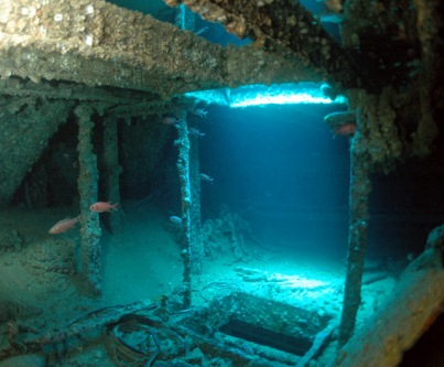
The national park's reefs have made it a popular diving destination
for divers from Sharm El Sheikh and surrounding resort towns.
Well-known diving sites are:
Shark Reef (shore and boat dive)
Shark Observatory (shore and boat dive)
Jolanda Reef (shore and boat
dive)
Old Quay (shore dive)
Aqaba Beaches (shore dive)
Camping
Area (shore dive)
Jack Fish Alley (boat dive)
Ras Zatar (boat
dive)
The Shark Reef and Jolanda Reef are located directly on
steep reef walls that drop down to 800 m. Due to the particularly strong
current at this point, you can encounter numerous species of fish and a
unique coral world. Jolanda Reef was named after a cargo ship that sank
here in 1980 and whose cargo - mostly toilet bowls - is still scattered
across the reef.