Location: Map
Height: 19,334 ft (5,893 metres)
Kilimanjaro is a mountain located in the
North-East of Tanzania and composed of three volcanoes: the Shira in
the west, culminating at 3,962 meters above sea level, the Mawenzi
in the east, rising to 5,149 meters above sea level. altitude, and
Kibo, the most recent geologically, located between the other two
and whose Uhuru peak at 5,891.8 meters is the highest point in
Africa. In addition to this characteristic, Kilimanjaro is known for
its summit ice cap, which has been in an accelerated retreat phase
since the beginning of the 20th century and which is expected to
disappear completely by 2030 to 2050. The reduction in snowfall
which is responsible for this is often attributed to global warming.
climate but deforestation is also a major factor. Thus, despite the
creation of the national park in 1973 and even though it plays an
essential role in the bioclimatic regulation of the water cycle, the
forest belt continues to tighten. Indeed, the mountain is notably
the cradle of the Maasai pastoralists to the north and west, who
need high altitude grasslands to graze their herds, and of the
wachagga farmers to the south and east, who cultivate plots ever
more extensive in the foothills, despite growing awareness since the
beginning of the 21st century.
After the surprise generated
in the scientific community with its discovery for Europeans by
Johannes Rebmann in 1848, Kilimanjaro aroused the interest of
explorers such as Hans Meyer and Ludwig Purtscheller who reached the
summit in 1889 accompanied by their guide Yohanas Kinyala Lauwo.
Subsequently, it constituted a land of evangelization which
Catholics and Protestants disputed. Finally, after several years of
German and then British colonization, it saw the emergence of a
Chagga elite which was a pillar in the birth of a national identity,
culminating in the independence of Tanganyika in 1961.
Since
then, Kilimanjaro has become an emblematic mountain, evoked or
represented in the arts and symbolized on many commercial products.
It is very popular with the thousands of hikers who climb it while
enjoying the great diversity of its fauna and flora.
geography
Around 350 km south of the equator is the
Kilimanjaro massif in north-eastern Tanzania, around 500 km north-west
of the city of Dar es Salaam and close to the Kenyan border (Kenya's
capital Nairobi is 200 km north-west). It is almost 560 km to the
northwest to the middle of Lake Victoria.
While the 750 to 1000 m
high terrain around the Kilimanjaro massif to the east gradually slopes
down to the Indian Ocean after the 2463 m high Pare Mountains, it goes
west and north into the mountains and highlands of Tanzania and Kenya
and to the south in the Maasai steppe. About 70 km southwest of the
mountain range rises the 4562 meter high Mount Meru.
The highest
peak of the massif and thus the highest point in Africa is the Kibo with
5895 meters. Kibo is 325 km south of Batian, the second highest mountain
on the continent in the Mount Kenya massif. Margherita Peak in the
Rwenzori Mountains is 900 km to the northwest.
The massif covers
an area of around 80 km × 60 km.
geology
The Kilimanjaro
massif is of volcanic origin. It is located on the eastern rift shoulder
of the East African Rift System. In connection with continental rifts,
there is usually volcanic activity, which can be explained by the rise
of asthenosphere material (often also mantle diapirs) and the resulting
thinning of the lithosphere. Unlike the Red Sea and the Gulf of Aden,
which are traversed by a mid-oceanic ridge, the East African Rift Valley
is not a plate boundary. However, a continental rift represents the
initial stage of the breakup of continental lithospheric plates. It does
not necessarily have to result in complete breakup and the associated
formation of mid-oceanic ridges. An example of a rift valley that did
not lead to the complete rupture of two continental lithospheric plates
is the Upper Rhine Plain.
On the Kilimanjaro massif, which is
around two to three million years old, what is believed to be the
largest eruption took place around 360,000 years ago. The Kibo is said
to have last erupted around 1700, since then the volcanic activity has
remained at a low level (fumaroles and solfatars), but has by no means
died out.
It remains unclear why no significant ash deposits from
past eruptions were found in the ice layers of the Kilimanjaro glacier.
The 1700 eruption is not considered scientifically proven, but comes
from oral traditions of the Chagga who settle on the mountain.
Mountaineers are currently reporting a strong smell of sulfur compounds
at the Reusch crater. The smell of sulfur compounds from the still
active fumaroles of the "Ash Pit" can also occasionally be detected at
Uhuru Peak, depending on the wind direction.
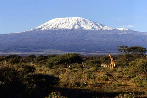
landscape
In
addition to glaciers, the rocky mountains are home to firn and snow
fields, frost debris deserts, numerous mountain streams and lush
vegetation, which merges into the jungle-like rainforest in the lower
mountain regions.
highest peaks
The Kilimanjaro massif
essentially consists of three extinct volcanoes, the highest of which is
the already mentioned Kibo ("the bright"). The summit of Kibo at 5895 m
is called Uhuru Peak. The summit plateau includes the 1.9 km by 2.4 km
Kibo Crater. In this lies the Reusch crater (about 800 meters in
diameter; up to 200 meters deep), at the edge of which there is a small
crater, the Inner Cone (5835 m).
About ten kilometers east of
Mount Kibo and connected to it by a wide saddle averaging about 4300 m
high, rises the rocky Mawenzi ("the Dark One"), which has no glacier, at
5148 m. About 15 kilometers west of the Kibo, the Shira (3962 m) can be
reached via an approximately 3700 m high saddle. The Shira is a flat
peak and also without a glacier.
glacier
Although the
Kilimanjaro massif is located in the tropically hot regions of the
world, it is the third glaciated high mountain range on the continent,
alongside the Rwenzori Mountains and the barely glaciated Mount Kenya
massif, which are also in equatorial East Africa.
The more recent
glaciation on Kilimanjaro is limited to Kibo. Between 1912 and 2009, the
ice cap shrank from 12 km² to 1.85 km², a loss of 85% of the area. The
main reason for this decline is a regionally drier climate since the end
of the 19th century. On the summit plateau, the Northern and Southern
Ice Fields formed the largest units, while the Eastern Ice Field with
the Rebmann Glacier and the Furtwangler Glacier were significantly
smaller. The slope glaciers were primarily on the southern slope of
Kibo, and remnants of the once mighty glaciation could still be seen on
the western flank.
The satellite photos[10] from the years 1993 and 2000,
which are often quoted by various media and are intended to illustrate
the decline, are only of limited significance with regard to the retreat
of the glacier. The 1993 photo shows the situation immediately after a
fresh snowfall, while the 2000 photo shows hardly any fresh snow. The
striking difference between the two images is thus based on the spatial
extent of the seasonal snow cover.
climate
The typical climate
in the region around the Kilimanjaro massif follows a pronounced annual
cycle of precipitation with two rainy seasons (March to May, October to
December) and two dry seasons, whereby the small dry season (January and
February) can also be rainy in some years. The average monthly
temperature at the base of the mountain reaches more than 20 °C all year
round. On the massif itself, the climate changes significantly,
especially in the vertical direction, which is reflected in the
succession of different vegetation zones. The lower areas (up to about
3000 m) are humid, often shrouded in cloud and covered with lush
rainforest vegetation. With increasing altitude, the vegetation becomes
sparser, temperature and precipitation decrease. Although the two rainy
seasons are still pronounced on the summit plateau of Kibo, the annual
amount of precipitation is only a tenth of that in the rainforest belt.
Even in the afternoon, the temperature rarely rises above freezing. This
makes the summit area a dry, icy environment.
bodies of water
Numerous mountain streams have their source on the Kilimanjaro massif,
which arise, for example, on the glaciated peak of Mount Kibo and rush
down the mountain slopes through the dense forests. They strive away
from the massif in all directions. The Pangani and the Galana later
arise from the union of such torrential streams and small rivers.
Because of the steep mountain slopes, there are only small lakes on
the Kilimanjaro massif. However, Lake Chala (also called Lake Jala; 877
m; 4 km²) is located at its southeastern foot, and Lake Jipe (707 m; 46
km²) is a little further south. Both bodies of water are on the border
of Tanzania and Kenya. At the southwest foot of the massif, already in
the Arusha National Park, are the Momella Lakes.
flora
Below
the glaciers, snowfields and frost debris deserts, there is sometimes
lush sprouting grassland that turns into shrubland. In the south, the
tree line reaches a maximum of 3500 m, with an average of 2700 to 3000 m
above sea level.
Due to the hot and humid climate, a unique flora
has developed in the hot and humid jungle, not only in the lower regions
of the mountains, in which countless plant species thrive with
magnificent growth - they are usually larger than elsewhere. The
rainforest is between 1400 and 3000 m altitude, it reaches a maximum of
3300 m altitude. In the vicinity of the mountain giant there are grass
and tree savannas and swamps.
story
pre-colonial period
The
Chagga people who live at the foot of the mountain worshiped the
mountain for centuries before converting to Christianity. After the
missionary work, altars were still aligned with the mountain. According
to local legend, Kibo and Mawensi represent petrified wives of the god
Ruwa. The story tells how Mawensi repeatedly abused Kibo's hospitality,
who then beat her. This explains the jagged rim of Mawensi's summit
(crater) and the fog that frequently lingers on Mawensi's summit is an
attempt to cover up this disgrace.
Around AD 100, the Greek
astronomer and geographer Ptolemy reported a high, snow-covered mountain
in the middle of Africa. About 1,000 years later, more reports of such a
mountain followed, this time from Chinese traveling traders.
A
detailed Spanish account from 1519 was not taken seriously in Europe and
fell into oblivion again.
It was not until May 11, 1848, when a
European, the German missionary, geographer and linguist Johannes
Rebmann from Gerlingen, stood in front of Kilimanjaro and reported to
Europe about the overwhelming sight of the snow mountain, that the
mountain came into the awareness of a broader public. However, Rebmann
did not describe himself as its discoverer, as he had previously had
reliable knowledge of the mountain from stories by Africans. Rebmann,
who worked without interruption in East Africa from 1846 to 1875, stayed
three times in 1848/1849 at the foot of Kilimanjaro. While the English
geographers did not believe his account of the Schneeberg for decades
due to its proximity to the equator, he received a medal of honor from
the Geographical Society in Paris. However, Rebmann greatly misjudged
the height, which he stated at around 3800 m without having measured it.
He gave the mountain range its name and most of the peaks that his
African companion gave him.
colonial era
During the colonial
occupation by the German Reich from 1885 to 1918, this massif formed the
highest mountain range in the Reich. The first climber Hans Meyer
renamed the Kibo as the highest German mountain in
Kaiser-Wilhelm-Spitze. The mountain huts built at that time were given
German names such as Bismarck or Peters Hut. At the beginning of the
20th century, the Hanover section of the German and Austrian Alpine Club
planned to build an Alpine Club hut between the Mawenzi and the Kibo at
an altitude of 4900 m. The necessary building material had already been
transported to the construction site. The start of the First World War
prevented the construction of the Alpine Club's highest hut. Only after
independence did the government of the Republic of Tanganyika become
aware that the peak of the Kibo was still called the Kaiser Wilhelm
Peak. In 1964 it was renamed Uhuru, which means freedom in Swahili.
first ascent
As early as 1861 and 1862, the German explorer Karl
Klaus von der Decken had dared to climb the mountain and only reached a
height of 4280 meters. The next documented attempts were made by the
missionary Charles New on August 14 and 26, 1871, who on the second
attempt on August 28, accompanied by a servant and a Chagga guide,
reached the snow line before having to turn back. In 1872 the
unsuccessful venture was reported in a publication of the Royal
Geographical Society.
The first climbers were the Leipzig
mountaineer, geographer and explorer Hans Meyer and the Austrian
alpinist Ludwig Purtscheller, who scaled the summit on October 6, 1889
after two failed first ascent attempts in 1887 and 1888 (Muini Amani
served as local mountain guide).
Meyer took a rock sample of
black lava rock from the central peak of Kibo and shipped it to Germany
to present it to Wilhelm II as a symbol of Germany's seizure of the
massif. Another he kept privately. In 1890, the emperor had the boulder
processed with other stones into a decorative piece, before which he is
said to have kept it as a simple paperweight. There are sources that
state that this work of art can still be viewed in the shell hall of the
New Palace in Potsdam. However, the stone seems to have been stolen some
time ago and replaced by a simple lump of lava - whether the original
got lost during the National Socialist era or later in the GDR can no
longer be traced. In 1980 an investigation was carried out in which the
lava stone made of biotite slate was exposed. This shale is found
nowhere on Mount Kilimanjaro. A piece of lava rock from the first
expedition from Meyer's collection now sticks in place. The second stone
is privately owned by one of Meyer's descendants.
More pioneering
acts
First descent on skis: In 1912, after their third summit ascent,
Walter Furtwängler and Siegfried König were the first to ski down from
the Kibo summit.
On the fourth summit ascent on February 13, 1914,
Clara von Ruckteschell-Truëb reached the crater rim at today's Gilman's
Point and was the first woman to successfully climb Kilimanjaro.
First overflight: On January 8, 1930, Walter Mittelholzer was the first
(motorized) to overfly Kilimanjaro. Among other things, he took aerial
photographs of the Kibo crater from an altitude of around 6,200 meters,
which were published in magazines and caused a great stir.
First live
television broadcast: On July 21, 2008, a team of reporters from ARD set
off from the Marangu Gate together with German mountaineers. Four days
later they reached Gilman's Point and Uhuru Peak. The world's first live
broadcast from Kilimanjaro was successful. The control and transmission
system was stationed around 2000 meters below at the Horombo Hut.
population and cities
The Chagga live in the settlements and
places on and around the Kilimanjaro massif, who mainly live from
agriculture, but also partly from tourism.
Cities in the region
are:
Arusha – major city 80 km southwest of the massif; There is
an international airport 50 km east of the city.
Marangu - city on
the massif, about 25 km from Moshi; optimal starting point for mountain
tours on the Marangu route
Moshi - Big city on the massif with
regional airport
Business
agriculture
The economy on the
Kilimanjaro massif is still characterized by agriculture, so that the
local Chagga live from agriculture, plantations and animal husbandry.
Bananas, coffee, corn, wheat and sisal are among the crops grown.
tourism
The region around the Kilimanjaro massif and the
Kilimanjaro National Park is very popular with tourists and nature
lovers. Many tourists also come to climb Kilimanjaro.
Moshi, just
south of the massif, offers a wide range of tourist facilities.
Southwest of the massif and about 30 km west of the city in the
direction of the neighboring city of Arusha is Kilimanjaro International
Airport, from which tourists can travel to Kilimanjaro and Serengeti
National Parks.
Rockclimbing
Climbing Kibo or Uhuru Peak
offers mountaineers minor technical difficulties, which is why more and
more people are trying to climb it despite the great physical exertion.
In the mid-1990s it was still around 15,000 a year, but around ten years
later this number had risen to 25,000. Among them are many who have
never undertaken a multi-day trek before. However, as a result of the
decrease in the partial pressure of oxygen associated with the high
altitude, altitude sickness often occurs, so that only about half of all
summit aspirants reach the highest point due to the physical exertion.
At the summit, the partial pressure of oxygen is half that at sea level.
In addition, there are sudden weather changes and significant
temperature differences between the base of the mountain, where the
thermometer regularly shows more than 30 °C, and its summit, where the
temperature can drop below -20 °C. Due to the wind chill factor, the
perceived temperature can appear even lower.
Five to seven days
should be planned for the ascent because of the adaptation to the high
altitude climate. In the NZZ, however, the high-altitude doctor Oswald
Oelz described the five days that are normally reserved for ascent and
descent on most routes as “physiologically attempted murder”. Anyone who
does not acclimate properly beforehand runs the risk of developing
pulmonary or cerebral edema. "It is not without reason that dozens of
people die every year on Africa's highest mountain," explained Oelz.
The ascent is subject to a fee, and the appointment of a Chagga
guide and the employment of local porters is required. The total fee in
2008 was 650 US dollars per person and is payable at the gates at the
entrance to the national park. An additional $170-$250 is added for the
guide and porters. The national park administration has announced
non-binding recommended prices for tips. Depending on the organization,
there are two to five porters for every tourist, including guides and a
cook (“Regulations and Fees”, on the Tanzania National Parks website).
Marangu Route
While the five routes Mweka, Umbwe, Lemosho, Shira
and Rongai are rarely used, the Marangu and Machame routes are much more
popular. The Marangu Route ("Coca-Cola Route"), which is the most
frequented according to park statistics and runs in the southeast of the
Kilimanjaro massif, is the only route that offers overnight stays in
huts instead of tents and has a maximum contingent of 70 guests per day.
The Marangu Trail begins on the southern slope of the massif and
initially heads north via Marangu (Marangu Gate; 1879 m), which is often
used as a starting point for mountain tours, and through the tropical
rainforest to the Bismarck Hut (Mandara Hut; 2720 m). Then - above the
tree line - through the initially luxuriantly sprouting grass and
shrubland ascending in a northwesterly direction, you reach the
Petershütte (Horombo Hut; 3719 m), which is located around five
kilometers south of the Mawenzi. From there it goes in ever thinning air
to the 4300 m high saddle, further west through the frost debris desert
running to the 1932 (first) built Kibohütte (Kibo Hut; 4720 m) on the
east flank of the Kibo. From there, after 987 m and a maximum of six
hours steeply uphill through numerous switchbacks and through a scree
landscape, Gilman's Point is only a few kilometers away (according to
the inscription on a sign posted there 5681 m) on the edge of the Kibo
crater. On the southern rim of the crater, another 214 m up, you reach
the Uhuru Peak (5895 m) called Kibo summit.
After a total of
around 34 km of walking you are on the rim of the Kibo crater, from
which large parts of Tanzania and Kenya can be seen – if the sometimes
unpredictable weather cooperates. For example, Mount Meru (4562 m) can
be seen, often rising above cloud cover and some 70 km away.
More
routes
In addition to the Marangu route, there are other paths that
lead to the Kilimanjaro massif, which belong to the difficult routes.
Among others these are:
Barafu Route - steep partial route from or
via Barafu Hut (4600 m) to Kibo
Lemosho route - starting point
Londorossi (2250 m)
Machame Route - Starting point Machame (1800 m)
Mweka route - starting point Mweka (1700 m)
Rongai or Kikelewa route
- starting point Nalemoru (2020 m)
Shira Route - Starting point
Londorossi (2250 m)
Umbwe route - starting point Umbwe (1700 m)
Western Breach Route – steep partial route from or past the Lava Tower
(4600 m) to Kibo
Thomas-Glacier-Route - route leads over the glacier
of the northern ice field - first ascent 28./29. October 2009
Oldest and youngest climbers of the mountain
At the beginning of July
2018, the American Montannah Kenney from Texas became the youngest
climber of the mountain at the age of 7.
The oldest woman to reach
Uhuru Peak was Angela Vorobeva at the age of 86 years and 267 days.
The oldest man on the mountain was American Robert Wheeler, who was 85
years and 201 days old when he summited on October 2, 2014.
Current research
Among other things, the University of Bayreuth has
been operating a scientific research station on the Kilimanjaro massif
for many years. It is primarily dedicated to researching the flora and
the distribution of precipitation in the rainforest belt. In recent
years, unique data on the climate history of the last millennia has been
collected through glacial cores (ice boreholes). The Universities of
Innsbruck and Massachusetts have been conducting a climate research
project since 2002 with the aim of understanding the climatological
reasons for glacier retreat. The body of scientific studies suggests
that the shrinking of Kilimanjaro's glaciers is a direct result of a
regionally drier climate since the late 19th century. A lack of snowfall
reduces the inflow to the mass of glaciers, and lighter fresh snow,
which reflects the sunlight well, protects against solar radiation. It
is not yet entirely clear to what extent and since when the regionally
dry climate will benefit from global warming. The less frequent
occurrence of strong positive events of the Indian ocean dipole plays a
probably decisive role, thereby reducing the supply of humid air masses
to East Africa. While climate change does not have a major impact on the
mass balance of glaciers via a direct increase in air temperatures on
Mount Kilimanjaro, it is considered likely to affect Indian Ocean
dynamics, thereby altering rainfall patterns on Mount Kilimanjaro.
Reception in literature and art
Carl Falkenhorst wrote in the
story about Adler's war and hunting adventures in East Africa, in the
non-fiction book Auf Bergeshöhen Deutsch-Afrikas (1890) and in the 1896
novel Zum Schneedom des Kilimanjaro about Kilimanjaro.
Ernst
Platz painted his picture of Kilimanjaro while accompanying Hans Meyer
on his fourth Kilimanjaro expedition in 1898. The painter Rudolf
Hellgrewe made some gouache paintings with the motif of Mount
Kilimanjaro. The painter and sculptor Walter von Ruckteschell climbed
the Kibo in 1914 with his wife Clara and Carl von Salis. He also painted
the Kibo as a colored watercolor. It is now in the German Historical
Museum in Berlin.
At the foot of the mountain, Ernest Hemingway
wrote his short novel The Snows of Kilimanjaro, which was filmed by
Henry King in 1952 as Snow on Kilimanjaro. Starring Gregory Peck, Susan
Hayward, Ava Gardner and Hildegard Knef, the film became a Hollywood
classic.
Pascal Danel had a number one success in 1966 with the
chanson Kilimandjaro (also called Les Neiges du Kilimandjaro).
The Dutch jazz formation The Kilimanjaro Darkjazz Ensemble was founded
in 2000 in Utrecht.
Mount Kilimanjaro is featured on a 2000
Tanzanian shilling banknote.
The name of the Linux distribution
Manjaro is derived from the mountain massif.