Location: Karimunjawa Islands Map
Area: 110,117 ha
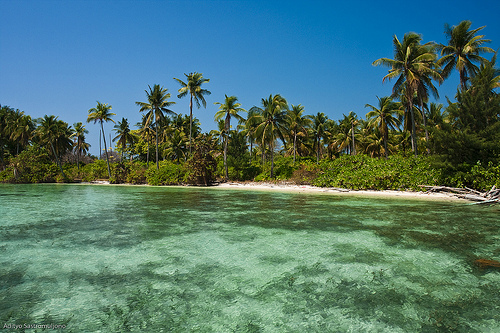
Karimunjawa National Park is a biosphere reserve protecting
jungles and coral reefs of Karimunjawa Islands in Indonesia.
Karimunjawa National Park covers a total area of 110,117 ha. The
Karimunjawa National Park is a national park marine located in
Karimunjawa Islands , located in the region of Central Java 80
kilometers from Jepara in the Java Sea . It was created in 2001.
The park is also a tourist attraction for its white sand
beaches, coral reefs, mountain hiking trails, Sunan Nyamplungan
Cemetery pilgrimage and the culture and traditions of the
Karimunjawa community.
Many researchers have been drawn to biodiversity and primary
forests of the Karimunjawa Islands. During the period of the
Dutch East Indies , many Dutch botanists went there to study
among which Teijsmann (in 1854), Koorders (in 1886), Schlechter
(in 1910) and Dammerman (in 1926).
Karimunjawa hosts five types of ecosystems: coral reef ,
seagrass and kelp , mangrove forest, coastal forest and
rainforest. Fresh water is found in small wells and forest
streams.
Karimunjawa National Park is one of six marine parks in
Indonesia .
It is divided into four areas:
sanctuary area ( 1,299 hectares): this is an area on the islands
of Burung and Geleang where sampling is prohibited; research
activities are allowed;
wilderness area ( 7,801 hectares): research is permitted and
tourist activity within certain limits; it includes Krakal
Besar, Kecil Kecil, Menyawakan, Cemara Besar, Cemara Kecil,
Bengkoang and part of Karimunjawa and Kemujan Islands;
area of use ( 4,431 hectares): includes Menjangan Besar,
Menjangan Kecil, Kembang, Kembar, Karang Katang, Karang Kapal,
Parang, Karimunjawa and Kemujan;
buffer zone ( 98,093.5 hectares): includes Karimunjawa, Kemujan,
Parang and Nyamuk; these islands are uninhabited.