Hours: 8am- 6pm
Winter: 8am- 4pm
Kerak, known for its mighty crusader castle
complex, is located in Jordan and is the capital of the province of
the same name. The city of Al Kerak has about 20,000 inhabitants and
is located on the King's Highway, which crosses Jordan from north to
south. From here a wadi runs west towards the Jordan.
In
biblical times the capital of the kingdom of Moab was here, in the
Bible, Mark 4:35-41 EU, the city is referred to as Qer Harreseth or
Kir of Moab. Later the place was ruled by the Nabataeans, after that
it was 105 AD. conquered by the Romans. Under the Byzantines, the
place was important as a bishopric, but then it fell into disrepair.
In 1142, under Paganus ("Payen le Bouteiller"), a mighty
crusader castle was built on a rocky outcrop, Crac des Moabites. Due
to its strategically favorable location on the caravan route between
Damascus and Mecca, it replaced the crusader castle of Montreal in
importance and for some time remained the capital of the rule of
Oultrejourdain, which belonged to the crusader kingdom of Jerusalem.
From 1183, Saladin repeatedly besieged the castle, and thanks to the
enormous stocks, the occupiers were able to hold out for a long
time. After the Battle of Hattin, in which he crushed the crusader
army near Tiberias, Saladin besieged the castle again for eight
months until the starving defenders had to surrender.
Under
the Ayubids and Mamluks, the now remodeled castle of Al-Karak
remained of great importance on the trade route from Damascus to
Egypt and the pilgrimage route to Mecca. Under the Ottomans at the
end of the 19th century. a garrison of 1,200 soldiers in Al-Karak,
the surrounding town had about 10,000 inhabitants. After the Arab
revolt, the city was added to the British Mandate under the San Remo
Agreement, and was the third largest city in the early days of the
Emirate of Transjordan.
By plane
The nearest international airport is
Amman's Queen Alia International Airport wikipediacommons (IATA: AMM).
By train / by bus
The one in the Jordanian mountains is not
connected to the railway network, there are bus connections to various
Jordanian cities.
Karak has three bus stations or stations, the
bus stations for regional connections are in the city, the national bus
station, however, outside on the King's Highway.
From the bus station
on Route 50, buses run to Amman (approx. 2 JOD) and south to Aqaba,
Tafilah and Ma'an (from there on to Petra).
Regional buses run
from the regional bus station near the town center to the Jordan Valley
and the surrounding towns.
On site, it is best to ask the locals,
who increasingly speak English, about the correct departure point for
the various bus connections. If there is no bus, there is always the
option of taking a taxi or a minibus (service taxi). Here you should
make sure that you don't pay too much. A taxi ride to nearby towns costs
3-5 dinars, to more distant towns 15-30 dinars.
In the street
The town of Kerak is bypassed by King's Highway 35, the highway
intersects here with Al Karak Street 50, which ensures a cross
connection between the Jordan Valley and the desert areas in the east.
For a short stretch, the desert highway and the main road run together.
It is about 125 km from Amman via the King's Highway and about 140
km from Petra.
In the village one moves on foot, from the bus station for the long-distance connections to the Crusader Castle the distance is almost 6 km, which is why it is worth using a taxi or service taxi.
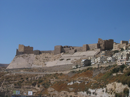
The old town of Karak is built on a triangular - wedge-shaped rock
hill, the ruins of the crusader castle are on its southern tip.
Karak Castle (قلعة الكرك). Tel.: +962 6 567 8444. Open: 08.00 - 16.00.
Price: 2 JOD (locals 0.25 JOD).
The main attraction in Kerak is
the Crusader Castle built in 1140/2 and named Crac des Moabites. At the
end of the 12th century Kerak was the capital of the rule of
Oultrejourdain, which belonged to the Crusader Kingdom of Jerusalem.
Kerak Castle's strategic location on a hill, which allowed the occupiers
to control the trade route between Damascus and Egypt, and its size
dwarfed Montreal Crusader Castle at Shawbak to the south. The castle,
built for a permanent garrison of several hundred Crusaders, was built
relatively quickly from rough blocks of basalt.
From here tolls were
levied and under Rainald of Châtillon trade caravans were attacked again
and again and even advances were made towards Mecca, which prompted
Saladin to besiege the castle several times. After a siege of 8 months,
during which the trapped people had to feed themselves on supplies from
the huge vaults, Saladin succeeded in taking the fortress in 1187;
according to a vow he took after attacking an unarmed caravan, Saladin
is said to have cut off Rainald's head himself.
After the conquest,
the fortress was expanded by the Mamluks, but now without time pressure
with much finer material and limestone.
Over the centuries, part of
the castle probably served as a quarry for the city of Al-Kerak, which
is also located on the hill, so that today only 3-4 of the 7 floors are
preserved.
In the castle, in addition to the Karak Castle Museum, you
can see service rooms such as a bakery and dining rooms, rooms in the
basement that served as a prison until the Ottoman era, and the remains
of a chapel and remains of a Mamluk palace. Most of the time, however,
only raw masonry can be seen, which conveys a feeling of power through
its thickness and size. The castle is only partially electrically lit
and there are few window openings, so it's a good idea to carry a small
torch when exploring the subterranean passages and vaults.
In the
evening, the castle is the scene of a light and sound show, in which the
walls are illuminated in a picturesque way.
Shrine of the tomb of the
prophet Noah
It is definitely worth making a small detour to the social center of Karak, old town with the souq. Here you will find shops of all kinds (fruit/vegetables, bakers, butchers, jewellers, etc.) as well as fast food stands and small snack bars.
There are many medium-priced restaurants with local and sometimes
international cuisine near the castle. It gets cheaper further towards
the souq. A secret tip is the Syrian restaurant with the green door at
the top of King Hussein Street.
When dining in Karak, one should
definitely try the Jordanian national dish, mansaf, which consists of
rice and lamb or chicken served with a sauce made from a special yoghurt
called jameed. There is a consensus among Jordanians that the best
jameed, and therefore the best mansaf, comes from Karak.
Moabite period
The territory of modern El-Karak was inhabited as
early as the Iron Age, around 2400 BC. e., and inhabited it by the
tribes of the Moabites. According to the Bible, the Moabites occurred
when Lot had incest (incest) with his daughters, who had previously
given him wine to drink. Soon both daughters gave birth to a son - Moab
(from whom the Moabites descended) and Ben-Ammi (respectively, the
progenitor of the Ammonites). Both the Moabites and the Ammonites were
enemies of the Jews.
In 850 BC. e. the great king of the
Moabites, Mesha, united the scattered tribes into the so-called Kingdom
of Moab, which also included modern El-Karak, called Kir Moab in those
days (literally, “the capital of the Moabites”) and performing mainly
agricultural functions. The capital of the kingdom was the city of
Dibon, which subsequently lost its capital functions, transferring them
to the ancient El-Karak. The advantage of Kir Moab was that it was
located on the main caravan route linking Egypt with Syria.
In
the ninth century BC. e. El-Karak is also mentioned in the Bible under
the names of Kir, Kirkhare, Kirhareshet and Kir Heres (Kir, Kir Haresh,
Kir Hareseth and Kir Heres). The Bible tells how the king of the kingdom
of Israel and his allies from the kingdom of Judah and Edom (Idumea)
destroyed the Moabites, and also laid siege to the king of Mesh in his
fortress of Kirkhare.
Further, El-Karak becomes dependent on
Assyria, whose ruler was then Tiglath-Pileser III (Tiglath-Pileser), who
exiled captives here from Damascus he conquered. Just the same, during
his reign, the policy of extermination of the conquered peoples, pursued
by the previous rulers of Assyria, was replaced by a policy of their
mass resettlement from one region to another. Further, El-Karak becomes
an important part of the Nabatean kingdom.
Greco-Roman period
During the entire heyday of Ancient Greece and since the conquests of
Alexander the Great, El-Karak did not lose its important strategic
functions and was known as Kharkha.
In 105 (according to other
sources in 205) AD. e. Kirkhare was conquered by the Romans, who renamed
it Karakmoba - "the fortress guarding the Kingdom of Moab". In 295 a.d.
e. The Roman Empire, which then owned Palestine (Eretz Israel), divided
it into three parts: Palestine Prima (Palestina Prima), which included
Judea and Samaria, with its capital in Caesarea; Palestina Secunda, with
its capital in Scythopolis, is the region of the upper Jordan and Lake
of Gennesaret; Palestine Tertia (Palestina Tertia), which included
Idumea and Moab with its capital in Petra. It was precisely in the
composition of Tertia that El-Karak was then located.
Byzantine
period
In the 4th century A.D. e. El-Karak went to Byzantium. During
the Byzantine Empire, it was a diocese. Archaeological excavations in
El-Karak did not give any finds that could testify to the features of
the architecture of that time. Traces of the Byzantine period in
El-Karak were found only in excavations in the Greek church of St.
George.
It is possible to judge the features of El-Karak of this
time by analyzing two mosaic maps located in the churches of Jordan: in
the city of Madaba (dated to the 6th century) and in the city of Um
Al-Rasas (created around 718).
On both maps, modern El-Karak (on
the map it is designated as Karakmoba) is depicted as a city surrounded
by a defensive wall; although the fortress was built by the crusaders
only in the XII century. In the southern part, the gates protected by
two towers are clearly visible. On the left side is a small church with
a red roof. In the picture, three rows of streets stretched from south
to north, the central one leading to a large church, most likely a
cathedral. A large church may correspond to the modern church of Jami'
al-'Umar, while a small church has two correspondences: either the
Church of St. George or the Church of Al-Qadir (al -Khadir). Such an
abundance of churches gave historians a reason to believe that El-Karak
was a diocese in the Byzantine period. The year 629 dates back to the
first reliably known confrontation between Muslims and the Byzantine
Empire. And already in 636, El-Karak was first conquered by Muslims, and
local Christians began to live in accordance with Sharia law.
Crusader period
The beginning of the formation of El-Karak, as an
impregnable fortress, fell on the XII century, when the crusaders
appeared in the Middle East. The construction of the Crusader fortress
began in 1142 under the control of Payen de Milla - in another
transcription Pagan or Paganus (French Payen le Bouteiller) - who was at
the same time the lord of Transjordan or the Land beyond the Jordan
(Oultrejordain) and the butler of King Fulk V of Jerusalem (French
Foulque V) , better known as Fulk the Young. The Crusaders called this
fort Krak Moab or Krak de Moab (Crac des Moabites or Kerak in Moab),
which means "fortress in the Land of Moab". Its construction took about
twenty years and it ended in 1161. Then El-Karak became the capital and
residence of the king of Transjordan (or Transjordan), taking over the
functions of the capital from the weakened fortress of Crac de Montreal,
built back in 1115-1116 in Idumea (slightly south of El-Karak), by order
of King Baldwin I. El-Karak had significant strategic advantages, being
located east of the Jordan River, since from its positions it was
possible to control the actions of nomadic Bedouin shepherds and monitor
trade routes from Damascus and Cairo, as well as hajj routes to Mecca .
Payen de Milla's successors - and his nephews Maurice (1147) and
Philippe de Milly (1161) (the latter was the seventh Grand Master of the
Templars) added towers and defenses on the north and south sides,
supplementing them with two deep moats (the southern ditch was filled
with water and served as a reservoir for its storage).
Krak de
Moab also entered the chain of fortifications stretching from the
Egyptian border (near the Gulf of Aqaba) to Turkey. El-Karak, like all
other points in this chain of fortifications, had to ensure the
transmission of messages throughout its entire length, through the night
use of an analogue of a heliograph or a light transmitter. Thus, a
message sent from a point located near the Gulf of Aqaba arrived at a
fortress located a little to the north. In turn, this fortress
transmitted the same message to another point, also located to the north
of it. And so one message in less than 12 hours could reach the Egyptian
border to the Turkish one, or in the opposite direction.
In the
early 1170s, Krak de Moab managed to successfully repel several sieges.
In 1176, he passed under the control of the notorious Renaud de
Châtillon, famous for his reckless and barbaric antics, and
distinguished by excessive cruelty. There are facts that Renaud de
Chatillon threw Muslim captives from the fortress wall, on their heads
they were wearing wooden boxes and with shackles around their necks.
They were thrown from a height of 450 meters alive and in full
consciousness, and death came only with a blow to the ground. Another
form of manifestation of the cruelty of Renaud de Châtillon was that he
ordered the captives to be put in very tight pits. For such barbaric
behavior, historians have nicknamed him the "Frankish Bedouin."
Renaud de Chatillon succeeded in gaining control of El Carak after
marrying Stephanie de Milly, daughter of Philippe de Milly, widow of
Humphrey III de Toron and daughter-in-law of Humphrey II. Violating all
previously reached agreements, he began to rob trade caravans and
pilgrims heading to Mecca, attacked the abode of Islam - Hijaz and
attacked Arab ports on the Red Sea, and even threatened the Muslim
shrine - Mecca. In particular, in the autumn of 1182, Renaud de
Chatillon organized a daring sea raid on ships that were built and
tested on the Dead Sea, and then dismantled and transferred to the Red
Sea coast with the help of camels. Renaud de Chatillon even managed to
capture Aqaba, thus creating a springboard for attacks on Muslim
shrines. Three of the five large ships for about six months inspired
fear and horror in the inhabitants of Muslim possessions.
Salah
ad-Din, the ruler of Syria and Egypt, who declared war on the state of
the crusaders, immediately reacted to these actions. He vowed to take
revenge and personally kill Renaud de Châtillon. In the spring of 1183,
Salah ad-Din's deputies in Egypt built ships and launched them into the
Red Sea. Soon the fleet (no more than 900 people) of Renaud de Châtillon
was forced to land and take the fight. In a three-day battle, the
crusaders were defeated, each of them ceremonially beheaded in different
cities of Salah ad-Din's empire.
In the autumn of 1183 and at the
end of the summer of 1184, Salah ad-Din tried to capture the fortress of
Renaud de Châtillon, but both attempts were unsuccessful. So, in 1184,
Salah ad-Din surrounded the city and began a siege. Just at that time,
the wedding of Humphrey IV de Toron and Isabella of Jerusalem took
place, and after a series of negotiations held with Salah ad-Din, he
graciously agreed not to attack the part of the castle where the
marriage ceremony took place, but focused on destroying the rest of the
fortress. But soon Salah ad-Din was forced to stop the siege due to the
fact that the army of his ally, King Baldwin IV, arrived in time to help
Renaud de Chatillon.
Either at the end of 1186, or at the
beginning of 1187, Renaud de Chatillon again robbed a rich Muslim
caravan, the proceeds from which amounted to 200,000 gold. There is an
assumption that the sister of Salah ad-Din, who may have been raped by
the 61-year-old Renault, could follow the caravan.
Salah ad-Din,
for his part, staged a raid on Christian territories in Galilee on May
1, 1187. Everything went to the decisive battle, which took place at
Hattin, where the crusader army suffered a crushing defeat. Salah ad-Din
generously allowed all the prisoners who had previously participated in
the battle to leave, except for Renaud de Châtillon, whom he personally
beheaded. And his head was used for propaganda purposes for a long time:
it was taken to Muslim cities in order to show the people that "the
ruler keeps his word, and their worst enemy, Prince Arnaut, is dead and
will not return." After this battle, Salah ad-Din again surrounded Krak
de Moab and, after an eight-month siege, took it by storm in 1188.
There are facts indicating that during this siege, the soldiers
defending the city gave their wives and children into slavery in
exchange for food. But after the capitulation, they received their loved
ones back from the generous conqueror, who even allowed them to freely
enter the territory of the Christians. It is impossible, however, to
assert with certainty that the case of the sale of wives and children
really took place during the siege of El-Karak; it is quite possible
that something similar happened during the siege of Krak de Montreal,
which held out for several months longer and capitulated only in 1189.
It is also quite possible that this happened during the sieges of both
fortresses. With these events, the process of gradual displacement of
the crusaders from the Middle East by Muslims began.
Muslim
period
Since 1188, Krak Castle, or al-Kerak, never again belonged to
the crusaders, unlike many other fortresses in the Middle East, which
changed owners throughout the 13th century (some fortresses repeatedly
passed from one hand to another).
During the reign of the
Ayyubids (until 1263) and the Mamluks (since 1263), the city became the
capital of the territory covering most of modern Jordan, while playing,
for two centuries, one of the central roles in the internal politics of
the Middle East. It is known from medieval sources that the Ayyubids
somewhat changed and reconstructed the castle and the city. El-Karak
later became the capital of an entire Mamluk kingdom when the
then-ruling Sultan an-Nasir Ahmad moved the capital from Cairo. But soon
he was forced to surrender his powers. Eight major attacks were carried
out on El-Karak, followed by sieges, before his brother and successor
as-Salih Ismail captured the fortress and regained the royal title.
During these sieges, El-Karak had the dubious distinction of being the
first city in the Middle East to be bombarded by Mamluk gunpowder guns.
In 1263, the Mamluk ruler Baibars I expanded the castle and built
new impressive towers, the largest of which stood on the northwestern
corner of the fortress. The entrance to the city was also rebuilt and
changed. At first glance, there was no entrance at all, since the gates
were removed. But it turned out that it was possible to enter the city
only through an underground passage, which can be seen even now. There
is a legend that the death of Baybars, which occurred in 1277, is
associated with another ruler of El-Karak, al-Qahir. According to it,
Baybars allegedly gave al-Kahir to drink poisoned koumiss from a bowl
with his own hands, from which he then drank himself by mistake. In 1293
three fortress towers were destroyed by an earthquake.
Throughout
its history, El-Karak was besieged a huge number of times, and never
until the 19th century could it be taken by attack. In 1840, Ibrahim
Pasha of Egypt captured the fortress of El Karak and destroyed most of
its defenses. In 1868, Mohammed al-Majali ruled in El-Karak, who
participated in the destruction of the Moabite stone.
In the
1880s, bloody battles between Muslims and Christians took place in the
El-Karak region. Calmness in the area was restored only after the
introduction of thousands of Turkish army. In this regard, in 1879,
ninety Catholic and Orthodox families were forced to leave El-Karak and
settle in Madaba and Maine.
The presence of deep moats at the
northern and southern extremities of the castle provided her with
greater security, but the appearance of sophisticated devices - throwing
weapons known as ballistas and trebuchets, meant that the defenders
could no longer feel completely safe during sieges. In the 19th century,
with the development of military technology, the use of cannons and
explosives, the defensive fortifications of El-Karak become unnecessary.
In the later period, El-Karak increasingly became a refuge for
rebels, and the castle was used as a venue for tribal councils. Since
1894, after the establishment of Turkish power over this territory, the
Mamluk palace inside the fortress was used as a prison. The Great Arab
Revolt ended Turkish rule over the city, which officially ended in 1918.
The twentieth century
After the First World War, El-Karak was
part of the southern province of the short-lived Kingdom of Syria. After
his fall, El-Karak went to the French, and in July 1920, local tribes
declared it an independent region of the Arab State of Moab (Arab
Government of Moab), with Rufayfan al-Majali at the head. In 1921, this
territory becomes the emirate of Transjordan. El-Karak loses its
defensive functions and for the next 60-65 years it becomes an
agricultural center. In the 90s of the 20th century, interest in
El-Karak began to show again: in the 90s, El-Karak began to position
itself as an important tourist center in Jordan; and in 1999, with the
help of the United States, a free economic zone was formed around the
city. These two events served as an impetus for the further development
of the city.
The Arabic name El-Karak comes from the Aramaic language, in which
karka means "walled city". But the root krk, meaning "surround,
enclose," was not characteristic of the Aramaic language. During the
times of Ancient Rome, Ancient Greece and the heyday of Byzantium, the
city was called Karakmoba (Karakmoba) - “fortress (castle) of the
Moabites”, which has several sounds (Charach-, Charak-), mentioned in
the writings of Claudius Ptolemy (mid-2nd century AD) .). It is likely
that the name Karakmoba was formed in the Persian period, when Aramaic
was the official language of government bodies.
In the Bible, the
territory of modern El-Karak is mentioned as the city of Moabites, under
the names: Kir (Kir) (by the prophet Isaiah), Kir-Heres (Kir-heres) (by
the prophet Jeremiah and the prophet Isaiah) and Kirkhareshet
(Kir-hareseth ) (in the Second Book of Kings and the prophet Isaiah).
Cyrus is mentioned only once in the book of the prophet Isaiah,
where he is described in parallel with the name Ar. According to some
researchers, the Moabites designated the area between Wadi Mujib and
Wadi Hasa by the name Ar. If Ar was the designation for a landscape area
or region, rather than a city, then Cyrus is most likely the capital of
that region. Also, in the language of the Moabites, Cyrus meant "city."
According to another version, the capital of this region could be the
city of Er-Rabbah - er-Rabbah (the ancient name of Rabbathmoba is
Rabbathmoba).
Kirkhare and Kirkhareshet were used in conjunction
with the concept of Moab, which is mentioned in the books of Isaiah and
Jeremiah. Thus, Kirkhare or Kirkhareshet was the capital of the Kingdom
of Moab. The books say very little about the location of the city, so
the records of King Mesh told scientists more about the history of the
area. According to them, Dibon was the capital of the Kingdom of Moab
during his reign. The future capital of the Kingdom of Moab (Kirkhare or
Kirkharesh) was located south of Wadi Mujib, and both El-Karak and
Er-Rabba had a similar position, so both of them could be called
Kirkhare or Kirkharesh and subsequently be the capital of the Moabites.
Only excavations around both settlements made it possible to
establish that Kirkhare or Kirkhareshet could mean "a city in a wooded
area" (from Arabic khir - "forest"). El-Karak is located in close
proximity to the wadi of the same name, and it is possible that the
slopes of the wadi at that time could be covered with trees. This is an
additional argument in favor of the fact that El-Karak was the capital
of the Kingdom of Moab. But this argument is not enough for a peremptory
assertion about the capital of the Moabites, therefore, an additional
argument in favor of El-Karak is its location on the main trade routes
of the Iron Age and the Roman-Byzantine period, while Er-Rabbah was at a
distance from them.
Fortress El-Karak more than once struck the imagination of
travelers who had the opportunity to admire it. There are many short
descriptions, notes, geographical sketches of travelers from Arab
countries and Europe. One of the visitors to El-Karak was the famous
Arab traveler and itinerant merchant of the 14th century, Ibn
Battuta. During his unusual journey from North Africa to China, he
decided to make a pilgrimage to the holy places for Muslims - Mecca
and Medina. Ibn Battuta began his journey in Damascus, and his
journey went south through the territory of modern Jordan, along the
Royal Road - King's Highway (from Arabic Darb al-Malik). In his
notes from 1326, he notes that the pilgrims made a stop at the
village of al-Taniya (al-Thāniyya), located on a hill to the east of
El-Karak, to purchase food to continue the campaign. From this place
one could see El-Karak in all its glory.
...Then the pilgrims
went to the El-Karak fortress, which is one of the most famous
majestic and impregnable fortresses. It is also called "Crow's
Fortress"... One gets the feeling that the city is surrounded on all
sides by deep moats...
Ibn Battuta, 1326
The origin of the
name "Crow's Fortress" (Arabic hisn al-ghurāb) - "Castle of the
Raven" is still not known for certain, but there are suggestions
that the name displays a raven depicted on the official seal of the
ruler of the crusaders and the head of the Reno fortress de
Chatillon. On his seal was an inscription that said that Renault was
the sovereign of the city of Petra, and an image of the castle in El
Karak. The bird on the obverse of the seal is thought to be the
fairy griffon.
The city is located in the west of Jordan, some distance from the
Dead Sea and the Israeli border. The city is located in a landscape
area, which is limited by Wadi al-Mujib from the north, Wadi al-Khasa
from the south, and the Dead Sea from the west. This area is quite
rugged terrain, cut by dry valleys. Soils are brown and grey-brown,
typical for shrub steppes. One of the names of this landscape area is
Ar.
El-Karak is located on a triangular plateau, which rises more
than 300-400 m above the surrounding area. The plateau is of natural
origin and is part of the eponymous wadi or dry valley (arab. wādīs -
"valley"). The city lies in the southern part of the plateau, the shape
of which narrows towards the south. Thus, on three sides the city is
surrounded by steep slopes of wadis.
The climate of El Karak is
typical Mediterranean - most of the precipitation occurs in winter. The
climate is arid, there is little precipitation - about 200-300 mm per
year. Since the city is located at an altitude of about 1000 m above sea
level, winters are quite cool and windy, with occasional snow. The
average temperature in January is about 10°C, in July - 28°C.
To the south of Al-Karak are two small towns: Al-Safiya, which specializes in chemical production (primarily potash fertilizers) and Al-Tafilah, where cement is produced. To the east of the city are important transport hubs of Jordan, and to the north (140-160 km) is the main industrial zone of the country - Amman and Ez-Zarqa. An important element in the economic and geographical position of El-Karak is its proximity to Israel, through the seaports of which the export and import of products to the city is carried out. El-Karak is located in the zone of irrigated agriculture.
El-Karak was once located on the so-called Via Regia (Latin for
"royal road"), which was an important trade route of the Middle East,
originating in Syria and ending in Egypt.
Now the city is located
to the west of the country's main highway - the Desert Highway, which
stretches across the country from north to south and unites all major
settlements into a single transport system. In the same place and in the
same direction, the Jordanian railway also stretches. The connection
between El-Karak and the main transport arteries of the country is
carried out through a network of smaller roads (through the following
transport hubs: El-Katrana, Maan, Jurf-er-Darawish and Amman). Buses
from Al-Karak regularly leave for Amman, Tafilah, Maan, Aqaba. El-Karak
is also connected by a network of roads to the country's only port,
Aqaba, through which most of the trade is carried out. In addition to
Aqaba, El-Karak uses Israeli ports to transport its products.
The
advantages of the transport and geographical position of El-Karak is
that it is located on the tourist route Amman - El-Karak - as Shubak
(aka Krak de Montreal) - Petra - Aqaba, which combines all the main
tourist sites of Jordan into a single complex . Thus, tourists who
travel from Amman to Petra often stop at Al-Karak.
In 1994, 18.6 thousand inhabitants lived in the city, in 1997 already
19 thousand people, and in 2004 the number of inhabitants exceeded 20
thousand. Now the city has about 22.5 thousand inhabitants, and in the
El-Karaka agglomeration lives about 68.8 thousand inhabitants (2003) -
this is 31.5% of the population of the Al-Karak governorate.
Most
of the inhabitants of the city are Muslims, but there are also
representatives of the Christian religion. Al-Karak has the highest
proportion of the Christian population in Jordan. Many of the Christian
families living in El-Karak today trace their origins to the Byzantines.
According to some data, the population concentrated in El-Karak and
around it is about 170 thousand people.
Industry
Al-Karak, along with nine other cities, is a special
industrial zone of Jordan (Karak Industrial Estate). In 1985, the
Jordanian government allocated Industrial Estates to create favorable
conditions for the development of infrastructure, industry and attract
private (including foreign) capital. Somewhat later, Jordan and the
United States signed an agreement under which goods produced in the
industrial zone (including in El-Karak), subject to a number of
conditions, have the opportunity to be supplied to the US market without
paying taxes and excises.
The Al-Hussein Bin Abdullah II
Industrial Estate (centered at Al-Karak) was established in October 1999
with the help of Jordan Industrial Estates Corporation (JIEC). In 2003,
there was a significant increase in exports from the El-Karak Industrial
Zone (in 2003, exports amounted to $100 million compared to $75 million
in 2002). During the first quarter of 2008, the number of newly
registered companies in this area increased by 400%.
The largest
enterprises located directly in El Karak are Camel Textile International
Corp. (Taiwan) and Honorway Apparel Ltd., which are engaged in the
tailoring and production of knitwear and clothing. The main market is
the USA. For export, the port of Aqaba (Jordan) and the port of Haifa
(Israel) are used. Both firms cooperate with well-known American
companies, such as Camel Textile International Corp. supplies its
products to the Fred Meyer Inc. super and hypermarket chain, and
Honorway Apparel Ltd. cooperates with Jacques Moret Inc. Handicraft
production of various consumer goods, souvenirs and other household
items is also widespread in the city.
Al-Karak has a small power
plant with a capacity of 24.5 MW. It has one gas turbine and three
diesel ones. The station mainly runs on diesel fuel. The staff of the
station has only 10 people.
Agriculture
On the territory
adjacent to El-Karak, irrigated agriculture is developing quite
intensively. Wheat and barley are predominantly grown here, and the
cultivation of olive and grapes is also locally widespread. El-Karak
governorate has 150,000-160,000 dunams of grain crops, of which 90,000
dunams are wheat. In 2007, Al-Karak Governorate produced 7,388 tons of
wheat. About 70% of the population is employed in agriculture. In
El-Karak itself, processing, processing and storage of grain, the
production of flour and bakery products, their redistribution and sale
are carried out. To provide sustainable water supply to agriculture,
cisterns are built, or water is withdrawn in the spring from wadi
al-Karak.
Tourism
All production in the city and surrounding
areas is aimed at providing everything necessary for the main sector of
the economy of El Karak - the tourism sector. At present, the tourist
business is actively developing in the city and, first of all, tourists
are attracted here by the well-preserved fortress of El-Karak. Tourists
visit the city mainly on the way from Amman to Petra.