Location: Gilgit–Baltistan region Map
Elevation: 8,000 ft (2,438 m)
The Hunza (Urdu: ہنزہ) is a valley traced by the river of the
same name near those of Gilgit and Nagar, located in the
Gilgit-Baltistan region, Pakistan.
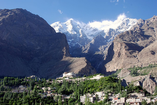
The Hunza valley
extends for approximately 7,900 km². The main city is Karimabad
(formerly called Baltit), also known as a tourist attraction for
the spectacular landscape given by majestic reliefs, such as the
Rakaposhi 7,788 m, the Ultar Sar (7,388 m) and the Bojahagur
Duanasir II (7329 m), and also Ghenta, Hunza, Diran and Bubli
Motin, peaks that all exceed 6000 m.
This region is also
known as the place where Shangri-La is located, the land where
youth is eternal. The American writer James Hilton was inspired
in the valley for his novel Lost Horizon (1933), staged in two
films: the first in 1937 and a remake in 1973.
Hunza was formerly a princely state bordering China to the
north-east and the Pamirs to the north-west, surviving until
1974, when it was finally dissolved by Zulfikar Ali Bhutto. It
was bordered by Gilgit Agency to the south and the erstwhile
princely state of Nagar to the east. The capital was the town of
Baltit (also known as Karimabad).
Hunza was an
independent principality for more than 900 years. The British
gained control of Hunza and the nearby Nagar valley between 1889
and 1892, following bloody clashes. The then thom (prince) Mir
Safdar Ali Khan of Hunza fled to Kashghar in China, seeking what
today may be called political asylum.
First Muslim thum
«The ruling family of Hunza is called Ayeshe (divine), from the
following circumstance. The two states Hunza and Nager were
previously united into one, governed by a branch of the
shahreis, the ruling family of Gilgit, whose seat of government
was Nager. Tradition reports that Mayroo Khan, apparently the
first Muslim thum of Nager almost 200 years after the
introduction of the Islamic religion to Gilgit, married a
daughter of the trakhan of Gilgit, who gave birth to twins
called Moghlot and Girkis. From the first descended the current
ruling family of Nager. Legend has it that the twins had shown
hostility towards each other since birth. Their father seeing
this and unable to solve the problem of succession, to satisfy
them both, divided his state into two parts (whose border was
marked by the river), giving Girkis the north and Moghlot the
south. »
Thum
The traditional name given to the ruler
of Hunza was thum, being also a name of respect used both by the
Hunza people and by the Nager people belonging to the Boorish
tribe. Shin use the term yeshkun for boorish.
«Both thums
are still referred to with the revered title soori. This appears
to have the same meaning as sri, a prefix commonly given to the
names of Hindu princes in India, to denote their honor and
prosperity. The wives of the thum are called ghenish, a word
almost identical to the original Sanskrit word for mother, and
their children are called gushpoor."
The Hunza valley is located at an altitude of approximately 2500
m. and, for many centuries, it provided the quickest access to
the kingdoms of Swat and Gandhara for a person traveling on
foot. The communication route was impassable for pack animals;
only human carriers could have crossed it, and in any case only
with the permission of the locals.
This region was easy
to defend as the paths were just under half a meter wide. The
mountain paths often climbed along desolate precipices, crossing
crevasses, with stones poised above, and thus constantly exposed
to the carelessness of the weather and the falling of rocky
blocks. These constituted the very scary "hanging passages"
reported in accounts of Chinese stories that terrified everyone,
including famous Chinese Buddhist monks such as Xuánzàng.
The temperature in May reaches a maximum of 27 °C and a minimum of 14 °C; while in October the maximum temperature is 10 °C and the minimum -10 °C. The tourist season generally runs from May to October, as the Karakoram Road is often blocked by snow in winter.
Today, the famous Karakorum Road runs through the Hunza region,
linking Pakistan to China via the Khunjerab Pass. Traveling from
the south to the valley, the Hunza region is on the left, and
the previous state of Nagar to the right of the Hunza river.
Regular bus and trucking services generally operate between
Gilgit and central Hunza (Aliabad and Karimabad) and also
between Gilgit and Sost Gojal. The PTDC office in Gilgit, Sost
and Islamabad organizes travel and transportation for visitors.
Spectacular scenery
The Hunza is one of the most impressive places in the world.
Many peaks rise above 6000 m surrounding the Hunza valley and
providing spectacular views of some of the most beautiful and
magnificent mountains in the world, including Rakaposhi (7788),
Ultar Sar (7388 m), Bojahagur Duanasir II (7329 m) , Ghenta
(7090 m), Hunza (6270 m), Darmyani (6090 m), and Bublimotin
(6000 m). The Hunza valley is also home to the ancient watch
towers, Baltit and Altit. The Rock of Baltit is located above
Karimabad, while the Rock of Altit lies low in the valley.
It is popularly believed that the valley provided the
inspiration for James Hilton for his 1933 Lost Horizon tale
where he talks about the mythical Shangri-La valley. While
traveling along the Karakorum road, beautiful scenery is
revealed to the visitor, who can observe the 65 km long glacier
'Batura', the second largest in Pakistan, surrounded by the
Shishper, Batura and Kumpirdior peaks. Coming to Sost, you can
continue your journey to Khunzhrav or turn west to witness the
mystical beauty of the Chipursan valley (also called Chapursan),
which has some of the most exotic tourist spots in the area.
From Yarzerech (or Yarzirich) you can see the majestic Kundahill
(6000 m), or hike along the Rishepzhurav to Kundahill to
experience the soothing scenery. After Yarzerech you can travel
past Lupghar, Raminj, Reshit, Yishkuk to Bobo Ghundi (Oston),
the shrine of Baba-e-Ghund, a saint of Afghanistan near the
border between Pakistan and the Wakhan region of Afghanistan.
Just as the valley is famous for its beauty, the Hunza people
are renowned for their friendliness and hospitality. Local
languages spoken are Burushaski, Wakhi and Shina, many people
understand Urdu. The Hunza Valley's literacy rate is believed to
be 90%. Virtually every child of the new generation studies up
to high school level. Many continue their studies in prestigious
schools and universities in Pakistan or abroad.
Most
Hunzas are Ismaelite Shiite Muslims, followers of His Highness
Prince Karim Aga Khan IV.
The Hunza region is home to
three ethnic groups:
The Lower Hunza region - (from
Khizerabad to Nasirabad is mainly inhabited by Shinaki who speak
the Shina language;
The Central Hunza region - (from
Murtazaabad to Ahmedabad) is mainly inhabited by burushaski
palanti.
The Upper Hunza region, known as Gojal - (from
Shiskat to Khunjerab is mainly populated by speakers of the
Wakhi language;
The majority of people are Ismaili Shia
Muslims, followers of the Aga Khan. The current Aga Khan IV has
provided much funding for the region to support agriculture and
the local economy through the Aga Khan Development Network.
In 2015, Hunza became a new district of Gilgit-Baltistan. A Gilgit-Baltistan Legislative Council Assembly (GBLA) venue has already been planned for Hunza.