Location: East Thrace Map
Open: 8am- 5pm daily winter
9am- 6pm daily summer
Kabatepe Information Centre
Tel. (0286) 814 11 28
Open: 8:30am-
6pm daily
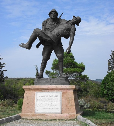
Mehmetcik Memorial
Open: 9am- 6pm daily
Çanakkale Wars Gallipoli Historical Area is a large area within the borders of Çanakkale province, at the southern end of the Gallipoli peninsula, covering almost the entire Eceabat district and covering an area of 33,000 hectares on the European side of the Dardanelles. It was established as a national park in 1973 and was removed from national park status in 2014 in order to be opened for development and was classified as a historical area.
With the proposal of the Ministry of Forestry, the Gallipoli
Peninsula, which has an area of 33,000 hectares, was first included in
the "forest regime" on 25 May 1973 with the decision of the Council of
Ministers numbered 7/6477. Then, due to its historical and natural
qualities, it was declared a national park on 22 November 1973, together
with the Martyrs' Monument as a masterpiece. Gallipoli Peninsula
Historical National Park Law No. 4533 was enacted.
In the said
law, the long-term development plan, which sets out the principles
regarding the protection, development, management and promotion of the
national park, was prepared by METU and approved on December 23, 2003.
The projects foreseen in the plan have started to be implemented under
the responsibility of the General Directorate of Nature Conservation and
National Parks, under its new name. The implementation of the long-term
development plan in the national park was determined by international
tender for the first time in the world. A Norwegian company won the
tender with its project that aims to ensure that visitors benefit from
the national park to the maximum extent without damaging the natural and
historical texture. Then the project was implemented.
Within the
scope of these projects, a competition for the logo that could best
represent the Gallipoli Peninsula Historical National Park area was
opened. 416 logo works participated in the competition. The jury, which
met on 28.11.2004, gave the first prize among the six logo works to be
awarded to the logo prepared by Ayşen Tuğba Doruk. In 2004 and 2005, the
martyrs' cemeteries and other monuments located in the national park
where the Gallipoli Peninsula is located were subjected to radical
maintenance or renovation and were reopened to visitors on March 18,
2005.
With the Law No. 6546 on the Establishment of the Çanakkale
Wars Gallipoli Historical Area Directorate, which was published and came
into force on 28 June 2014, the national park status was abolished and
reclassified as a historical area.
You can reach the Park from Edirne and Istanbul via Tekirdağ and Gelibolu; It can be reached from Ankara, Bursa and Izmir by ferry service from Çanakkale to Kilitbahir and Eceabat. The nearest airport is in Çanakkale. It is possible to reach Çanakkale Airport from Ankara and Istanbul with THY's scheduled flights.
The places where the World War I Çanakkale Sea and Land Battles took
place are within the Gallipoli Peninsula. In addition, a wide range of
sunken ships, cannons, trenches, castles and bastions and hundreds of
other war-related remains are located here, as well as war graves and
monuments of more than 60,000 Turkish martyrs and more than 250,000
Australian, New Zealand, British and French soldiers.
Battlefields, war graves, monuments and war-related ruins are registered
as "historical sites" and "cultural assets". It also has many
"Archaeological sites and monuments" dating back to 4000 BC. Among the
wide variety of "natural protected areas and monuments" are beaches,
ravines, groves mixed with Mediterranean shrubs (maquis), striking
geological and geomorphological formations, a salt lake (which was a
coastal lake until recently) and the unique 15th century military
architecture. There is an interesting "cultural heritage" collection
containing examples of
The Gallipoli Battles are a defense epic that the Turkish nation put
up against the world's most powerful states in their most difficult
period. In these battles, some of the fronts and redoubts where the
battle took place are mentioned in the archives as follows, and all the
martyrs' cemeteries are named according to the fronts in the list given:
"Ağıldere, Anafartalar, Arıburnu, Bahrısefid Boğazı, Cesarettepe,
Conk Bayırı, Conk Tepe, Çatlaktepe, Çanakkkale, Erenköy, Ertuğrul,
Esnay-ı Harp, Gelibolu, Horhortepe, İntepe, Kabatepe, Kanlısırt,
Kanlıtepe, Karakaş hills, Keçidere, Kerevizdere, Kılıçbayırı, Kireçtepe,
Kirte, Kocaçimen, Kumkale, Lapseki, Eceabat (Mydos), Merkeztepe,
Mestantepe, Orhaniye, Ovacık, Seddülbahir, Seddülbahir Jerusalem
Beytepe, Sandıklıtepe, Sarıbayır, Sığadere, Sığadere-Eski Hisarlık,
Soğandere, Soğanlıdere, Suvla, Tengertepe , "buluphisar, Yassıtepe,
Yeşilsırt, Yusufcuktepe, Zebnebarın Geiyorum, Zığındere (given as
Sığadere in some sources)."
The west, south and east of the area are surrounded by the Aegean
Sea and the Dardanelles, respectively. However, there is a
territorial border in the north of the area. 8 of the 12 settlements
in Çanakkale's Eceabat district are within the historical area.
These; They are the villages of Alçıtepe, Behramlı, Bigalı,
Büyükanafarta, Kilitbahir, Kocadere, Küçükanafarta and Seddülbahir.
There are four settlements outside the historical area: Beşyol,
Kumköy, Yalova and Yolağzı. These settlements are marked in red on
the map. Even though they are outside the historical area
boundaries, there are war cemeteries or martyrs' cemeteries in these
villages and they are very close to the historical area boundaries.
Services and accommodation
Of course, apart from the rich
beauties of the environment and the battlefields, you can benefit
from the museum, picnic and camping areas in Kabatepe. It is also
possible to benefit from the Eceabat Administration and Visitor
Center and the daily tour area and countryside casino there.
Accommodation in tents and caravans is available.