Location: Saare county Map
Area: 2,673 km2 (1,032 sq mi)
Ferry: from Virtsu to Kuicastu (Muhu Island)
Info: Tallinna 2, Kuressaare 453 3120
Open: mid- May- mid- Sep: 9am- 7pm daily
mid- Sep- mid- May: 9am- 5pm daily
Official site
Saaremaa Island is situated in the Baltic Sea as part of
Saare County of Estonia. Saaremaa Island covers an area of total
of 2,673 km2 (1,032 sq mi). The easiest way to get to the island
is to take a ferry from from Virtsu to Kuicastu on a Muhu Island
that is connected to the Saaremaa Island via a road. The name of
Saaremaa Island translated as "the land of an island". First
human settlement on Saaremaa Island date back to 5000 years BC.
During early medieval period Scandinavian sagas claim that
Vikings waged several battles with the residents of Saaremaa
island. In 1206 Danish king Valdemar II constructed a fortress
here, but it didn't last long. The garrison itself burned down
their stronghold and left these lands.
These lands were
some of the last in Europe to accept Christianity as their
official religion. During the Northern Crusades Livonian
Brothers of the Sword captured Saaremaa along with surrounding
lands in 1227. However at the Battle of Saule in 1236 Lithuanian
army defeated this Catholic Order and the residents of the
island rebelled against the invaders. After the war ended with a
treaty Saaremaa Island became part of Bishopric of Ösel-Wiek. In
1559 the Danish took control over the island until they ceded
these lands to the growing Swedish Empire by the Treaty of
Bromsebro.
Saaremaa Island along with surrounding lands
was transferred again in 1721 at the completion of the Great
Northern War. Russian Empire defeated the Swedes and captured
lands along a Baltic Sea. The island was occupied by the German
forces during World War II in 1941. Three years later it was
liberated by the Soviet Army during counterattack. Although
remains of the war are still visible in some part of the
islands. Bullets, human remains as well as other artifacts have
been discovered here.
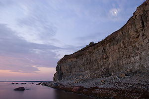
Baltic states were some of the last places in Europe to accept Christianity. It happened only in the late Medieval history. The tradition beliefs were polytheistic. A common modern misunderstanding about pagan beliefs is that it was in harmony in nature. In reality it was less attractive. Panga Cliff that is pictured on the right was an important religious site for the native population of the Saaremaa Island. It reaches a height of 21.3 meters with a total length of 2.5 km. Ritual site here was a site for animal sacrifices. Some historians claimed that the site was occasionally used for human sacrifices as well as it was common in the basin of the Baltic Sea. This barbaric rituals were largely driven out by arrival of Christianity, but some peasants kept their traditional pagan beliefs. Some of them secretly met on the cliffs during difficult times to perform ancient rituals. The last pagan sacrifice was recorded in 1960's.
Location: Kaali küla, Pihtla vald, Saare maakond
Tel. (+372) 459 1184
Kaali Meteor Craters is a cluster of perfect round holes found on the island located 18 km from Kuressaare towards Kuivastu. There time of the meteor impact is somewhat a subject of debate. Some date it back to the 4000 years BC, while other date it in 600 BC. Scientists believe that the energy of impact measured at 80 TJ or 20 kilotons of TNT, which comparable with the Hiroshima bomb. The explosion also burned forest in the radius of 6 km. Pieces of rock howled down to the ground and hit the earth with the velocity of 10- 20 km/s. These parts measured from 20 tons to 80 tons. The largest crater left by the impact measured 110 meters in diameter. Other smaller impact impressions measure from 1 meter to 40 meters at the radius of 1 kilometer within the main central crater.
Mihkli Farm Museum is a small ethnographic museum situated in the Viki village. Traditional houses have been preserved as a museum of a traditional way of life on the island.
Bishop's Castle is located in the town of Kuressaare. It measures 42 by 42 meters with guard towers that reach height of 40 meters. The first castle was constructed on this site in 1222 by the invading Danes. They constructed a watchtower that is known today as the Long Hermann Tower. In case the citadel fell this was the last resort for its defenders. Bishops castle gets its name due to a fact that it was used by the bishops of the Bishopric of Ösel-Wiek. The central castle dates back to 1345- 65. Further military fortifications were strengthened by a new wall that was added in the 1430's. In 1559 the castle was sold by Kuressaare Bishop Johann von Munchausen to Danish king Frederik II. During the Northern War in the 18th century the castle along with surroundings lands were captured by the Russian troops.
Bishop Castle is surrounded by many legends. The most famous legend states that in 1785 Russian engineers were reconstructing the bastions and defenses of the Kuressaare Castle. In the eastern corner of the courtyard they discovered an immured basement. Remains of the old table and a chair stood in the center. Male skeleton was scattered at the old table and a chair. Locals claimed that these were remains that belonged to a medieval knight who was immured in the basement on the orders of the bishop in the early 16th century. Reformation shook the Catholic Church and some actions had to be taken. Baltic bishops asked for an Inquisitor. Young Spaniard came to Kuressaare Castle with intent to catch anyone who sympathized the new religious movement. The bishop decided to test the new Inquisitor with a beautiful girl who was supposedly in a threat from a Church. He fell for it and tried to save her. He wrote a letter and hid it in the bread crust, warning his love of his plan. The letter quickly made it to the table of the bishop and the young knight paid with his life. He was imprisoned in the castle basement and then it was walled it.
Another legend claims that Long Hermann Tower once served as a courtroom for the bishop's trials. Anyone who was accused was thrown down the shaft in the floor of the room. It was known as a Lions' Shaft since hungry lions were kept on its bottom. They carried out death sentence for the bishop. Some believe that bishop Henrik III became a victim of this execution during the argument with the members of the chapter of the castle in 1381.
Today Kuressaare Castle is open to the public and serves as a museum. Additionally several shops show local artisans at work. You can join and create glass, pottery, weapons and other artifacts that were useful in the medieval times.
Location: Map
Constructed: 13th century
Poide Church situated on Saaremaa Island is a medieval Catholic church that was constructed in the 13th century. It was one of the earliest churches in the region after Livonian Order captured the island in 1227. Catholic warrior monks constructed a fortress on this site. However in 1343 Saint George's Night Uprising was started by the native population of the Saaremaa Island. They destroyed the stronghold of the Order, but they kept the chapel that once stood in the Southern part of the castle. Miraculously the structure survived despite centuries of neglect. In 1940 a lighting struck the bell tower of the church. A large crevice is still visible on side of the tower. During World War II the interior of the church was looted. We only have few pictures of its original interior.
Saaremaa is the main island of Saare (Saare Maakond) County, which
includes the surrounding islands of Muhu (Mohn), Abruka (Abro), Vilsandi
(Filsand), Ruhnu (Runö) and various smaller islands.
The second
largest Estonian island Hiiumaa (Dagö) is located about six kilometers
from the northernmost point of the Pammana Peninsula. The north-south
extent of the island is about 88 kilometers, the distance between the
westernmost and easternmost point is 90 kilometers. Saaremaa is
connected to neighboring Muhu by a navigable causeway, and there are
ferry services from Kuivastu (Kuiwast) on the east coast of Muhu to the
mainland port of Virtsu (Werder). The main town on the island and
district is Kuressaare (Arensburg) with around 16,000 inhabitants on the
bay of the same name in the south of Saaremaa. The second largest town
is Orissaare (Orrisaar) in the northeast.
About 36,000 people
(13.5 per km²) live in Saaremaa, which is about three percent of the
Estonian population. The isolated location west of the mainland left the
island relatively untouched by the Russification policy of the Soviet
occupation period, 98% are Estonians, about 1.2% are of Russian descent,
0.2% each are Ukrainians and Finns.
The road network on the
island is very well developed. In total, the road length is about 3100
km, with only part of the route being paved. In the sparsely populated
areas in the south-west and north-east as well as in the interior of the
island, there are mainly roads with a gravel surface. There are several
daily bus connections from Kuressaare to the capital Tallinn as well as
to Pärnu and Tartu via the main road 10, which are maintained by the
transport of coaches and regular buses on the ferry between Kuivastu and
Virtsu. Boat connections to surrounding islands and the mainland are
available via the ports of Roomassaare (to Abruka and Ruhnu) and Triigi
(to Sõru on Hiiumaa). Roomassaare is home to the island's only airport.
The ferry service from Mõntu to Ventspils in Latvia was discontinued in
2009.
The 1300 km long coast of Saaremaa is largely characterized
by large peninsulas and offshore smaller islands (about 600), the
peninsula Sõrve (German Sworbe) even extends up to 30 km in the Gulf of
Riga and ends in the southernmost point of the archipelago in the
village of Sääre, marked by a 52 meter high lighthouse built in 1960
(originally from 1646).
Despite the predominantly rocky and flat
coastal strip that merges into the sea, there are cliffs such as the 22
m vertical Panga Pank on Küdema Bay or the Undva Pank cliff on the
Tagamõisa peninsula in the north-west of the island. The northwestern
adjacent peninsula Harilaid is a former island (estn. laid = small
island), the lighthouse at Cape Kiipsaare dates from 1933 and threatens
to fall into the sea due to its tilt caused by strong wave erosion.
Saaremaa is largely characterized by a strikingly flat topography,
the highest peak, the Viidu Raunamägi, is located at Kihelkonna
(Kielkond) in the west of the island in the Viidumäe Nature Reserve
established in 1957 and only reaches about 54 m. Like large parts of the
mainland, Saaremaa is densely forested, approx 40% of the island is
covered by forests. Larger lakes are the Suur Laht (Eng. Big Bay), the
Mullutu Laht at Kuressaare, the Karujärv (Eng. Bear Lake) at Kärla
(Kergel) and the Ristissoo. Of geological interest is the dolomite mined
in quarries near Kaarma (Kermel) and processed into handicrafts.
The average height of the island is about 15 m above sea level. Since
the last ice age, Saaremaa has been gaining around two millimeters in
height every year due to post-glacial land uplift.
Due to its location on the eastern edge of the Baltic Sea,
Saaremaa is in a cool, moderate climate zone with mild sea weather.
Consequently, the island has long, warm summers and mild winters; strong
winds lead to frequent weather changes with precipitation (> 50 mm)
mainly in the autumn and winter months.
In July and August, the
temperatures reach an average of 16-20 °C, sometimes up to 25 °C.
February is the coldest month in Saaremaa with an average temperature of
around −4 °C.
Flora and fauna
Saaremaa has a rich flora and
fauna, due to the mild, maritime climate conditions. Around 80% of the
plant species native to Estonia are found on the islands. About 120 of
the species found here are considered protected. The most well-known
rare plant species on the island is the Saaremaa rattlepot (Rhinanthus
osiliensis, estn.: Saaremaa robirohu), which usually blooms in swampy
lowlands. In addition, 35 out of 36 species of orchids found in Estonia
grow here.
Saaremaa has a diverse animal world, many of the
native seal species live in the coastal waters, such as e.g. B. the gray
seal. In addition, the islands are in the migratory range of numerous
bird species that use Saaremaa as a stopover on their journey in spring
and autumn, e.g. B. Brent geese and eider ducks. Nevertheless, the fauna
of the mainland is far more species-rich than that of the islands in the
west of the country. Bears, lynx and moose, for example, are rarely
found on these.
Archaeological finds indicate a settlement since at least 3000 BC. In
the Scandinavian sagas, Saaremaa is mentioned as Eysysla (German island
district), in older German and Swedish records Oesel is also mentioned.
The Salme Viking Ship Graves were discovered in 2008 at the Salme
Isthmus. The clinker-built ships (a rowing boat, probably a sailing
ship) contained the remains of seven and 33 males, respectively. The
first protohistoric find of ships in the eastern Baltic Sea is dated to
700-900 AD. Swedish rune stones indicate Viking activity that lasted
until about 1050 AD.
With the beginning of the expansionist
policy of the Teutonic Order in the 13th century, Saaremaa came under
foreign rule, and it was not until 1227 that the island population was
subdued. However, the German order soon had to cede parts of the island
to the Ösel-Wiek diocese, which provoked constant armed conflicts. The
order's consolidation of power served above all to erect large castles
in Kuressaare and Maasi in the north-east of the island, although only
the remains of the wall bear witness to the latter. In 1343, rebels
managed to temporarily expel the order from the island by destroying the
knight's castle in Pöide (Peude). Despite numerous uprisings against the
occupying power, the order managed to maintain sovereignty over the
island until 1559.
The economic opening up and development of
Saaremaa was promoted above all in 1858 with the opening of ship
connections to Riga and Saint Petersburg and in 1888 with the inclusion
of ferry connections to Muhu and the Estonian mainland. In 1894 the port
of Roomassaare was built and, two years later, Saaremaa was connected to
Muhu with the construction of a land bridge over the Väike Väin (Little
Sound). In 1912, independent energy supply was made possible with the
construction of an electricity plant.
During the First World War,
the island was an important base for the Russian fleet. At the end of
1917 it was captured by the Germans in Operation Albion; after the
armistice of 1918 they withdrew again. When the newly formed Estonian
state gained independence on February 24, 1918, the island became part
of Estonia.
The German-Soviet non-aggression pact of 1939 forced
the Baltic states to station Soviet military forces on their territory
and led to a renewed occupation of Estonia. Numerous residents of the
island were deported. Two Soviet air bases were built on Saaremaa, from
which Soviet air forces flew some attacks on the suburbs of Berlin after
the invasion of Germany between August 7 and September 5, 1941, e.g. B.
on the night of August 8, 1941 under the command of Colonel Yevgeny
Preobrazhensky.
During World War II 1941-1944, the island was
occupied by the Germans, and many residents of the Sõrve (Sworbe)
peninsula were evacuated in 1944. On October 8, 1944, one of the
fiercest battles of the war in Estonia took place on Sõrve between the
retreating Germans from Saaremaa and the Soviets (Operation Aster)
advancing from the east. Today, near Tehumardi, a 21 m high memorial in
the form of a broken sword commemorates this nightly conflict, which
cost thousands. During the defense until the end of November 1944,
almost the entire peninsula was razed to the ground, old gun
emplacements and dilapidated fortifications can still be found on the
southern tip of Sõrve. The ravages of war and the deportations and
evacuations reduced the island's population by more than 30%.
In
the post-war period, Saaremaa was almost isolated from the mainland due
to its strategically important location on the western border of the
USSR and the massive presence of the Soviet military stationed there
(around 4000 hectares of restricted area) - even Estonians needed a
permit to enter the island .
With the renewed Estonian
declaration of independence in 1991, Saaremaa gained the right to
self-determination and self-development.
Side roads on the island are often unpaved, as is the case throughout
Estonia.
Local and long-distance public transport is carried out
exclusively by buses. Bicycles can only be taken along in exceptional
cases.
Ferries connect the island with mainland Estonia
(Virtsu-Kuivastu ferry route), Hiiumaa Island and Ventspils (Latvia),
although the latter was discontinued in 2009. For several years, the
Estonian Road Administration has been considering building a bridge to
the Estonian mainland, the so-called "Saaremaa fixed link".
In
winter, when the sound between Virtsu and Kuivastu is sufficiently
frozen, the island can be reached by land vehicles via a route marked on
the ice.
Flights to the capital Tallinn are possible from the
airport.
David Johann Rahr (1677–1753), Protestant Lutheran Pastor in Kielkond
(Est. Kihelkonna) and Mustel (Est. Mustjala)
Eberhard Gutsleff the
Younger (around 1700–1749), Evangelical Lutheran Superintendent of Osel
Fabian Gottlieb von Bellingshausen (1778–1852), Baltic German seafarer,
Russian officer and Antarctic pioneer, discoverer of the Antarctic
mainland and Peter I Island, born in Lahhetagge (estn. Lahetaguse) in
the southwest of the island
Johann Christian Bechler (1784–1857),
bishop of the Moravian Church and composer, born in Korupe
Eugen
Gustav Dücker (1841–1916), professor at the Düsseldorf Art Academy, born
in Arensburg (estn. Kuressaare)
Carl Oswald Bulla (1855–1929), German
photographer
Heinrich Oswald von Saß (1856–1913), painter of the
Düsseldorf and Munich schools
Johannes Aavik (1880–1973), Estonian
linguist and writer, reformer of the Estonian language, born in Randvere
Erwin Rahr (1880–1919), Russian officer, born in Arensburg (estn.
Kuressaare)
Walter Flex (1887–1917), German poet, fell in 1917 near
Peude (estn. Pöide) in the east of the island
Viktor Kingisepp
(1888–1922), founder and leader of the Estonian Communist Party, born in
Karmel (estn. Kaarma)
Louis I. Kahn (1901–1974), American architect
and urban planner, born in Arensburg (estn. Kuressaare)
Voldemar Väli
(1903-1997), Estonian wrestler and Olympic champion, born in Arensburg
(estn. Kuressaare)
Dorothea Kreß (1924–2018), German athlete
Arnold Rüütel (born 1928), Estonian politician and former President of
the Republic of Estonia, born in Pahavalla
Kurt Treu (1928–1991),
German papyrologist and classical philologist, born in Karja
Ivar
Karl Ugi (1930–2005), German-Estonian chemist who made important
contributions to organic chemistry, born in Arensburg (estn. Kuressaare)
Tarmo Kõuts (1953), Estonian vice admiral and politician, born in Pihtla
Ain Anger (born 1971), Estonian opera singer, born in Kuressaare
Ott
Tänak (born 1987), Estonian World Rally Champion, born in Kärla