Location: Provence-Alpes-Côte d'Azur Map
Area: 226,837 acres
Highest mountain: Barre des Écrins 13,458 ft (4,102 m)
The Écrins National Park is a French national park created in
1973, having been prefigured since 1913. It is located in the
Alps, extending over a large part of the Écrins massif. It is
located in municipalities of two departments: Isère
(Auvergne-Rhône-Alpes region) and Hautes-Alpes
(Provence-Alpes-Côte d'Azur region) and straddles the boundary
between the Northern Alps and the Southern Alps in France,
formed by the watershed line between the hydrographic basin of
the Isère and that of the Durance.
Its heart is
classified as a category II protected area by the World
Commission on Protected Areas of the International Union for
Conservation of Nature (IUCN, the world's leading
non-governmental organization devoted to nature conservation),
while its optimal area Membership is classified as category V.
The history of the park begins on December 31, 1913, when the
French State acquires 4,000 hectares of mountain on the heights
of Saint-Christophe-en-Oisans (municipality of Isère located in
the Écrins massif). Thus was created the “Parc de la Bérarde”
(hamlet of Saint-Christophe-en-Oisans), modeled on the Swiss
reserve in the Engadine founded four years earlier. It was a
question of defending the mountain against the invasion of the
pastures, which involved erosion, deforestation and torrential
disorder; but quickly, the scientific and educational aspects of
the project emerged. The call for subscriptions had barely been
launched when the First World War broke out and the process of
giving national parks official status was interrupted.
The Water and Forests Administration did not, however, renounce
the protection measures already implemented and, without a
regulatory basis, continued to administer the state land
acquired and leased with the idea of leaving it to evolve
freely. The Bérarde park then changed its name several times,
being unofficially assimilated to a national park during the
interwar period: "National Park of Oisans", then in 1923
"National Park of Pelvoux" enlarged to 13,000 ha. . The park
nevertheless lost this qualification of "national park" in 1962
and became a state park, "private domain of the State subject to
the forest regime", before being reborn as the Ecrins National
Park in 1973.
In 1960, in fact, the status of national
park was created. The first four parks were then born, the
Vanoise national park and that of the island of Port-Cros in
1963, that of the Pyrenees in 1967, and that of the Cévennes in
1970. That same year, a creation mission was formed for a Écrins
national park, based on the former Bérarde park, which since
1962 has become a simple national forest. And it was finally on
March 27, 1973 that the Ecrins National Park was created, by
decree of the Prime Minister.
The first agents of the
park were recruited by competition from 1974, and from 1976 the
park acquired a reception area: the Maison du Parc, in
Vallouise; this house was visited by President Valéry Giscard
d'Estaing on August 27, 1977. It was this year that the first
actions of the Park began: an unsuccessful attempt to
reintroduce ibexes, and the creation of the first scientific
databases on August 25 June 1977. The following year, in 1978,
the first action plan for the reception of tourists in the
peripheral zone was set up.
The 1980s were marked by
major works: the Haute-Romanche hydroelectric development
project caused much ink to flow in 1980, then the securing of
Lake Arsine (Briançonnais) at an altitude of more than 2,000
meters from the spring of 1986. Finally, in 1989, sixteen ibexes
were successfully reintroduced in the Valbonnais; the animals
came from the Vanoise and Vercors parks.
In 1990, a new
graphic charter was introduced for all national parks. It
includes in particular the famous spiral composed of a multitude
of elements (animal, vegetable and mineral silhouettes)
organized according to a spiral structure. It is a metaphorical
representation of the movement, richness and complexity of life.
In 1991, the headquarters of the park was moved to the Domaine
de Charance, in Gap, where it is still located.
The 1990s
were marked by conventions: the first climbing convention was
signed in 1992, and many mountain pasture management contracts
were signed with the shepherds in 1993. In 1995, in addition to
the reintroduction of thirty-one ibexes, the park innovates by
creating the first integral nature reserve in France, in the
Lauvitel valley. On July 11, 1996, the park signed the
Sustainable Development Partnership Charter with the Minister of
the Environment, Corinne Lepage; this charter will then be
rolled out with local authorities, the National Forestry Office
and the chambers of agriculture of the Hautes-Alpes and Isère.
In 2006, a new law laid down the principle of a "heart of
the park" protected zone (former central zone) and a "membership
area" (former peripheral zone): the reform of 14 April 2006
provides for the writing of a new charter, signed by the
municipalities of the peripheral zone and the public
establishment that is the park. The draft charter was adopted
unanimously in May 2011, and in 2013, for the fortieth
anniversary of the park, 46 municipalities signed this charter.
The Economic, Social and Cultural Council of the Écrins National
Park was set up in 2008, in Monêtier-les-Bains.
2010 saw the structuring of the “Sentinel Alpine Pastures”
program, allowing a study of alpine pastures and the
repercussions of climate change on them, with a dialogue
established between shepherds, breeders, scientists, pastoral
technicians and Park agents.
The park charter was voted
unanimously by the Board of Directors of the Ecrins National
Park in 2011. On December 28, 2012, a decree from the Council of
State approved the charter of the Ecrins National Park.
In October 2012, international recognition for the scientific
work carried out in the Lauvitel Integral Reserve came with an
IUCN classification (International Union for the Conservation of
Nature).
The 2010s saw the creation of several elements
and services intended for the general public: the new Maison du
Parc in Vallouise and the Rando-Écrins website were inaugurated
in 2014, and the following year the Esprit Parc national brand
was born in the Écrins. In the same decade, several additional
municipalities joined the Écrins National Park charter, bringing
their total number to 53 in 2015, which corresponds to a
membership rate of 90%. At the same time, scientific studies are
continuing, with, for example, the study of the evolution of the
geographical distribution of flora species and the geolocation
of ibexes in the park in 2013. An online atlas of the fauna and
flora of the park, Biodiv'Écrins, was launched in 2016.
In April 2019, the park was included in the IUCN Green List, a
certification that recognizes protected areas whose management
is effective and whose governance follows the standards
established by said organization.
At the end of December
2019, the core zone of the park was extended by 705 ha with the
integration of two contiguous reserves in the heart of the park:
the national nature reserve of the upper valley of Saint-Pierre
and the national nature reserve of the peaks of Combeynot, in
order to simplify the management of these spaces.
The
park has been distinguished by the Council of Europe as a
European High Mountain Park. In 1996, the Council of Europe
renewed the label obtained 5 years earlier.
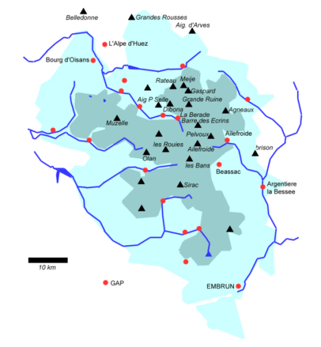
The territory of the Ecrins National Park (91,800 ha), created in
1973, extends in an area located between the cities of Gap (12
kilometers as the crow flies), Briançon (13 kilometers) and Grenoble (23
kilometers) . It is bounded by the valleys of Romanche, Guisane, Durance
and Drac.
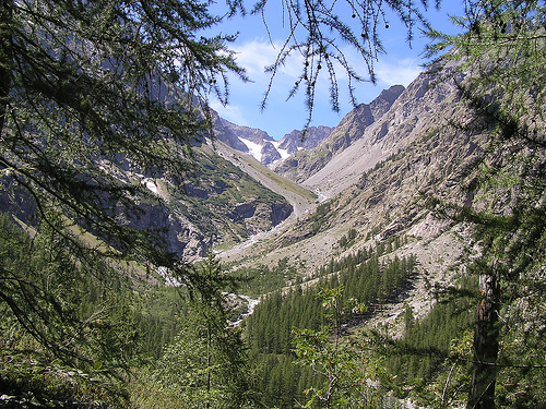
The park is located between an altitude of about 800 m
and 4,102 m, and it has about a hundred peaks located at more than 3,000
meters and about forty glaciers (covering about 17,000 hectares).
It has 740 km of maintained and marked trails, including the GR 54
(Tour de l'Oisans), and around thirty mountain refuges. It contains many
peaks including that of La Meije, rising to an altitude of 3,983 m above
the village of La Grave, Mount Pelvoux (3,946 m above sea level) and
that of the barre des Écrins, a point highest point in the Park at an
altitude of 4,102 m.
The Parc des Écrins is watered by a dozen main torrents, which then
flow into two distinct rivers: the Drac to the west and north and the
Durance to the east and south.
Drac tributaries
From
easternmost to westernmost:
the Romanche has its source in the Plate
des Agneaux glacier, at an altitude of 2,143 m. It flows into the Drac
after 78.3 km.
the Vénéon rises from the Pilatte glacier, at an
altitude of 2,577 m. It flows into the Romanche after 33.5 km.
La
Bonne has its source at Lac des Pissoux, near the refuge of Font Turbat,
at an altitude of 2,632 m. It flows into the Drac after 40.1 km.
the
Malsanne has its source at Lac du Vallon, at an altitude of 2,493 m. It
flows into the Bonne after 15.4 km.
the Séveraisse takes its source
from the Chabournéou glacier, at an altitude of 2,336 m. After watering
the Valgaudemar valley, it flows into the Drac after 32.9 km.
the
Drac Blanc has its source in the Rougnoux valley, at an altitude of
2,419 m. Also called Drac de Champoléon, he joined the Drac Noir in the
commune of Champoléon.
the Drac Noir is considered the parent branch
of the Drac. It therefore has its source in the Mourre-Froid massif, at
an altitude of 2,423 m, and flows into the Isère after 130.2 km.
Durance tributaries
From easternmost to westernmost:
the Guisane
has its source at the Col du Lautaret, at an altitude of 2,552 m. It
flows into the Durance at Briançon, after 27.7 km.
the Gyr and the
Onde form the Gyronde, which flows into the Durance after 23.6 km.
the Fournel has its source at the Pic de la Cavale, at an altitude of
2,908 m. It flows into the Durance at Argentière-la-Bessée after 19.2
km21.
the Biaysse has its source at the Col d'Orcières, at an
altitude of 2,611 m. It flows into the Durance after 17.4 km.
the
Rabioux has its source in the Vallon du Tissap, at an altitude of 2,251
m. It flows into the Durance after 15.5 km.
the Réallon torrent has
its source in the Montagne de Charges, at an altitude of 2,350 m. It
flows into the Lac de Serre-Ponçon after 19.8 km.
Lakes
The
park also has a large number of spectacular lakes.
The Lauvitel is
the deepest and largest in the Park: it is between 25 and 35 ha in area
and between 40 and 65 m deep. It is located at the foot of the Aiguille
de Vénosc, near the resort of Les Deux Alpes.
Very close to it are
the Lac du Plan Vianney which is home to many salmon and the Lac de la
Muzelle.
Lac du Lauzon is located below Les Rouies, above the
Gioberney torrent.
Lac des Pisses is located near the winter sports
resort of Orcières.
The Crupillouse lakes, in Champoléon, are
accessible by a hike offering viewpoints and passages near the
waterfalls.
The Pétarel lakes are a tourist attraction in the
Valgaudemar valley.
Lac du Pavé is the highest and coldest in the
park: at an altitude of 2,820 m, the water is 4°C on the surface.
Many polar lakes, such as the lakes of Eychauda, Rouies or the Arsine
glacier, remain frozen over for most of the year.
The climate of Les Écrins tends to be very harsh, despite its position relatively close to the South. Indeed, its many glaciers condition the climate of the massif, and make the Ecrins one of the coldest parts of the Alps. In winter, at an altitude of 4,000 m, the temperature can locally drop to −45°C. Lower down, in La Grave for example, the conditions are still very harsh. In summer, the conditions are quite mild during the day and cold at night. Be careful however, above 2500 to 3000 m, the cold persists, whatever the season.
The landscapes of the park come from a rifting creating half-graben basins of ten-kilometre dimension separated by large crustal normal faults and then subsiding passive margins.
In the Ecrins National Park, at least 4,149 species of plants and animals have been observed. They are distributed differently according to the existing environments, in connection with the geological conditions, the altitude, the climate, the exposure, etc.
The fauna of the park covers more than 350 species of vertebrates
(mammals, birds, reptiles and amphibians) and an as yet unknown number
of invertebrates (insects, snails, centipedes, spiders, beetles,
crayfish, etc.). Most of the first are known by observers, while the
second category still has many discoveries to be made.
Many
species of mammals are present in the park, such as:
chamois (around
12,000)
the Alpine ibex (about 600 individuals divided into 3
populations)
the alpine marmot
the mountain hare
the ermine
the red squirrel
the red fox
certain bats, including mouse-eared
bats
The gray wolf and the Eurasian lynx sometimes pass through
the Park.
Birds are also very present, with in particular the
golden eagle (37 pairs recorded), the rock ptarmigan (one of the 10
species of birds to be preserved as a priority in the heart of the
national park), the black grouse, the griffon vulture , the echelette
tichodrome, the alpine snow vetch, the Tengmalm's owl and European pygmy
owl, the bearded vulture (which does not nest there), the peregrine
falcon and the eagle owl.
Among the insects, the Rosalie of the
Alps is very present, and among the reptiles, we find the asp viper.
There are more than 2,000 species of plants on the territory of the park. These are distributed according to the environment, but also according to altitudes, exposures, etc. Pines and larches are very common on the slopes, as for flowering plants, we can mention in particular the emblematic species such as the blue thistle of the Alps, the Venus slipper, the edelweiss, the genepi, but also the leaf saxifrage opposite (Saxifraga oppositifolia) which has been found up to 4,070 m altitude in the park, which makes it the tallest plant in France. But there are many other species, including fungi, lichens, etc. The presence and maintenance of certain species in environments such as hay meadows is sometimes linked to ancestral agricultural practices.
The main missions of the national park are the preservation of
species and environments, the knowledge and transmission of knowledge
and good accessibility of the massif to the public.
Knowledge of
species and environments, reception of scientific research
Through
studies and regular monitoring of environments and species, the park
provides a better understanding of them, their functioning and their
evolution. The impact of climate change is also an important point of
these studies and monitoring. The park is also part of a naturalist data
collection network (including the Observatory of mountain galliforms,
the Observatory of large fauna and its habitats, the Large carnivores
network of the National Office for Hunting and wildlife for monitoring
the two large predators, wolf and lynx). The public can also participate
in observations and data collection using certain park-related websites.
It also allows the implementation of measures for the protection and
management of species and spaces, in order to protect and perpetuate all
of this natural heritage. The park also works in conjunction with local
actors and professionals such as farmers, in order to preserve these
environments; concerning agriculture, the mowing of certain meadows, in
continuity with the agro-pastoral practices of past centuries, is, for
example, beneficial to the preservation of certain environments and
certain species: this preserves their biodiversity, prevents the
establishment of bushes or shrubs which, in time, would close these hay
meadows if they were no longer maintained. In addition, the park offers
financial sponsorship actions concerning certain rare animals and
fragile populations, in order to finance research on them and facilitate
their protection.
Reception, public awareness and environmental
education
For many years, the Ecrins National Park has been carrying
out environmental awareness and education actions, with the general
public (more than 200,000 visitors per year in its reception areas), as
well as in schools. of the municipalities that make it up (with visits,
discovery activities and thematic interventions in the classes).
The park and its agents maintain more than 700 km of trails allowing
hiking on its territory, promoting the discovery of it. A large part of
the paths that make up the long-distance footpath 54 (GR 54 or "Tour des
Écrins"), one of the three main long-distance footpaths in the French
Alps, are part of it.
Support and development of the territory
The park is in contact with many actors of the territory in order to
better know, preserve and develop in the respect of the natural and
cultural heritage, the territory and the activities in the communes.
The Ecrins National Park has for many years published guides and
works concerning the territories where it is located, both on the
subject of landscapes, environments, fauna and flora, as well as the
built heritage and the activities of the inhabitants of the valleys.
In 2011, the Geotrek application was created by the park in order to
manage the trails and enhance the hiking routes; it is published under a
free license and has been taken over and improved by other structures in
France (national parks, regional natural parks, communities of
municipalities and departmental councils).
Since 2013, the data
collected by the Ecrins National Park has been fed into the National
Inventory of Natural Heritage.
Since 2016, Biodiv'Écrins, an
online atlas of the fauna and flora of the Ecrins National Park, has
promoted the dissemination and sharing of knowledge around these themes.
This tool was inaugurated by the Secretary of State for Biodiversity at
the National Museum of Natural History in Paris. It allows access by
Internet to all the observations of the agents of the park for more than
40 years; it is built with the GeoNature-Atlas tool, published under a
free license, developed by the Ecrins National Park.
The Écrins National Park is a public administrative establishment
placed under the supervision of the Ministry of Ecology, Sustainable
Development and Energy.
Nowadays, the administrative headquarters
of the Ecrins National Park is located in Gap. It includes: the
management, the general secretariat and the three thematic services:
local planning/development, scientific, and reception/communication
(thematic services ensuring the follow-up of transversal missions).
The Park is divided into 4 geographical sectors
(Champsaur-Valgaudemar, Embrunais, Vallouise-Briançonnais,
Oisans-Valbonnais), where the Maisons du Parc are located, and includes
a total of 7 locations at a territorial level . The latter each have a
field team, with a decentralized operation in relation to the whole of
the Park, whose missions are the management and animation of their
sector on a daily basis. The Maisons du Parc have a role of welcoming
visitors and are also meeting places with local actors.
There is
a contract of objectives between the French State and the public
establishment of the Ecrins National Park. The most recent is that of
2015-2017.