Location: Northeast of Nîmes
Height: 49 m (160 ft)
Constructed: 1 AD
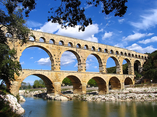
The Pont du Gard is a three-level bridge intended for the
passage of a Roman aqueduct. It is located in Vers-Pont-du-Gard
between Uzès and Remoulins, not far from Nîmes, in the French
department of Gard. It spans the Gardon. Probably built in the
first half of the 1st century, it ensured the continuity of the
Roman aqueduct which carried water from Uzès to Nîmes. According
to the latest research, it would have ceased to be used at the
beginning of the sixth century.
In the Middle Ages, the
piles of the second floor were indented so that the structure
could be used as a road bridge. From the sixteenth century, the
exceptional architecture of the Pont du Gard having attracted
attention, the work benefited from regular restorations intended
to preserve its integrity. A road bridge was attached to it in
1743-1747. The highest known aqueduct bridge in the Roman world,
it is classified as a historic monument by the 1840 list and was
included on the UNESCO World Heritage List in December 1985.
Lower
level: 6 arches, 142 m long, 6 m wide, 22 m high
Middle level: 11
arches, 242 m long, 4 m wide, 20 m high
Upper level: 35 arches, 275 m
long, 3 m wide, 7 m high
On the upper level runs the rectangular
channel of the water pipe, which is 1.80 m high and 1.20 m wide and has
a gradient of 0.34 ‰.
On the lower and middle floors of the
bridge there are arcades made of 61 wedge stones weighing up to six
tons. The middle level piers are precisely supported on the lower level
piers to minimize stress on the lower arches. Starting from the middle,
the span of the arch becomes smaller and smaller towards the bank.
The Pont du Gard is the monumental part of an aqueduct more than 52
km long (52,702 m), which brought water from the Fontaine d'Eure,
located at the foot of Uzès, to the Roman city. of Nemausus, today
Nîmes, then at its peak. The waters of the source come partly from the
Alzon river, which passes through the surroundings of Uzès, and from the
waters collected from Mont Bouquet, located closer to Alès. The aqueduct
itself is a masterpiece of engineering, testimony to the extraordinary
mastery of the ancient builders: the drop between the starting and
finishing points is only 12.6 m, the average slope general being 24.8 cm
per km. Because of the relief, the aqueduct meanders through the small
mountains and valleys of the scrubland of Uzès and Nîmes.
The
aqueduct of Nîmes was probably built in the 1st century AD, as the
ceramics attest. Tunnels dating from the time of Augustus had to be
circumvented, which shows that the construction of the aqueduct is
later, and the coins found in the reservoirs of the city of Nîmes, where
the waters of the aqueduct were collected , are not prior to the reign
of Emperor Claudius (41-54). It is therefore believed that the
construction of the aqueduct, of which the Pont du Gard is a part, must
have taken place between the 1940s and 1950s. It is estimated that a
thousand workers were needed for its construction, working over five
intense years.
Its average flow has been estimated at 40,000
cubic meters of water per day, or about 460 liters of water per second.
The running water took a whole day to reach its catchment point by
gravity to the distribution structure, a sort of water tower called a
castellum divisorium, still visible on rue de la Lampèze in Nîmes.
Nemausus had a number of wells, as well as a nearby source: the
construction of the aqueduct was therefore not a vital necessity, but
rather a prestigious work, intended to supply the thermal baths, baths,
gardens and other fountains in the city. In fact, the bridge symbolizes
Roman scientific genius. The challenge was all the greater as the bridge
had to withstand the formidable floods of the Gardon.
From the
4th century, however, maintenance began to fail, while limestone
deposits occupied two-thirds, sometimes three-quarters, of the pipe. It
is now estimated that it had ceased to function at the beginning of the
sixth century, at the time when, following the battle of Vouillé, the
Franks took control of the region of Uzès, while the Visigoths
maintained in Nîmes: contemporary ceramics have been found in the layers
of abandonment, and the aqueduct was then used as a stone quarry:
concretions detached from the walls of the canal were used by local
residents for their own constructions and to cover sarcophagi of the
Saint-Baudile cemetery in Nîmes.
Built on three floors with stones extracted from the very nearby
Roman quarries, the top of the bridge culminates at 48.77 m in height
above the Gard at low water. Over its greatest length, the structure
currently measures 275 m, whereas it measured 360 m during its
construction.
Lower floor: 6 arches, 142.35 m long, 6.36 m wide,
21.87 m high.
Middle floor: 11 arches, 242.55 m long, 4.56 m wide,
19.50 m high.
Upper floor: 35 arches, 275 m long, 3.06 m wide, 7.40 m
high. This floor lost 12 arches, and initially measured 360 m; it was
preceded by a 130 m long abutment; At the origin of this abutment was
discovered in 1988 a control structure. The arches were 16 Roman feet
(4.75 m) across, while the piers were about 10 by 10 feet (3 m).
Canal: 1.80 m high and 1.20 m wide, slope of 0.4%.
The
observation of the internal face of the pillars of the second floor of
the bridge, built in large apparatus, reveals the work of the Roman
builders: block cutting techniques (traces of squad) and construction
techniques (blocks placed in squares and header and protruding blocks
for setting up scaffolding). As you approach, you can see the precision
of the assemblies: each block was linked to the others by chiselling the
joints on site.
Numerous traces and engravings dot the surface of
the bridge. These are assembly marks indicating the position of the
keystones of the vaults, for example, "FRS II" (frons sinistra II, i.e.
"left face 2") or symbols such as the "phallus", symbol apotropaic (that
is to say "used to deflect malefic influences"), or else various marks
left by builders of all eras for whom the Pont du Gard was an obligatory
stage.
The bridge has a convex curvature of its upper floors on
the upstream side. This deformation has long been attributed to the
desire of the builders to ensure the resistance of the structure, as one
would do for an arch dam. Following microtopography measurements carried
out in 1989, it is now interpreted as the result of diurnal expansion
under the effect of sunlight, which causes a displacement of
approximately 5 mm; the stones find their place during the night. The
repetition of this phenomenon over the centuries would have led to the
present form of the bridge.
The bridge was almost entirely built in the dry, that is to say
without using mortar, the stones – some of which weigh six tonnes –
being held together by oak tenons. Only the highest part, at the height
of the canal, is made of mortar-bound rubble. The shell limestone comes
from the Estel quarry located about 700 m downstream from the monument,
on the banks of the Gardon. This material, known locally as "worm
stone", has a fairly coarse texture, lending itself very well to
carving.
The heart of the pipe (where the water circulated) is
distinguished by its sealing system: a Roman concrete based on lime,
painted with a reddish paint, based on ferric oxide, which avoids
degradation due to limestone. . The pipes are about 1.80 m high.
On site, the blocks were mounted using a squirrel cage in which the
workers sat, providing the necessary power to the winch. A complex
scaffolding was erected to support the bridge during construction, the
faces of which still bear the marks: one can make out everywhere the
scaffolding supports and, on the piers, the projecting edges which
supported the semi-circular wooden assemblies intended maintaining the
vaults. It is assumed that the construction lasted from three to five
years (about fifteen years for the whole of the aqueduct of Nîmes), with
800 to 1,000 workers on the site. The number of stone blocks used and
50,400 tons the weight of the whole has been estimated at 11 million.
Each of the large vaults is made up of independent adjoining vaults
(four on the lower floor, three on the second floor), which gives the
whole the ability to resist the slight movements and settlements that
are inevitable over time. This partition of the vault into independent
rings is only found in Narbonnaise, for example at the Roman bridges of
Sommières, Boisseron, Ambrussum, Nages-et-Solorgues.
The aqueduct
located on the third level has a floor made of mortar and pebbles and
rubble walls. Its size allowed a man to easily maintain it.
Analyzes have proven that the constituent of the "red bowl", found on
the Pont du Gard responsible for ensuring the watertightness of the
structure, and what Émile Espérandieu will assume to be maltha, is in
fact a milk of lime mixed with red quartz sand of a precise grain size
and heavily loaded with ferric oxide. Many Roman hydraulic structures,
such as the aqueduct of Nîmes, are sealed by a tile cement casing.
From the Middle Ages to the 18th century, the bridge suffered significant damage. At some unknown time, but probably around the twelfth century, twelve arches on the third floor were destroyed and the stones recovered as building material. Subsequently, it was used as a passage to cross the river: the piles of the second level were notched in order to leave more room for the increasing traffic, but this dangerously destabilized the whole structure.
The Renaissance, which raised Antiquity to the rank of absolute
model, did not fail to take an interest in the Pont du Gard, one of the
most spectacular Roman monuments remaining in France.
Charles IX
passed in front of the bridge in December 1564 during his royal tour of
France (1564-1566), accompanied by the Court and by those who were the
Great of the kingdom, his brother the Duke of Anjou, Henri de Navarre,
the cardinals of Bourbon and Lorraine.
As early as 1647, the
Bishop of Nîmes alerted the States of Languedoc to the danger of ruin
presented by the bridge. He specifies, in his address to the deputies,
that a fund of 1,500 pounds had already been set up for the repairs to
be made, but that it was blocked "in the hands […] of the bourgeois of
the city of the Holy Spirit". .
On January 10, 1660, Louis XIV
and the Court, then in the South of France on the occasion of the
negotiation of the peace of the Pyrenees, went to see the Pont du Gard.
In 1696, Nicolas de Lamoignon de Basville, intendant of Languedoc,
worried about the stability of the building, had an estimate drawn up
for the repair by Abbé Henri de Laurens and Augustin-Charles d'Aviler,
architect of the Province. The work, supported by the States of
Languedoc, lasted until 1704: the indentations in the piers were partly
filled in and, bypassing each pier, corbelled passages were built to
widen the way.
In 1730, in the first volume of the General
History of Languedoc, Dom Claude Devic and Dom Joseph Vaissète reviewed
current knowledge of the Pont du Gard. In the absence of ancient texts
and at a time when archeology was only in its infancy, the dating was
very uncertain: they recalled that Nicolas Bergier in his Histoire des
grands chemins de l'Empire romain (1622 )19 attributed the construction
of the aqueduct to Agrippa (around -63 - around -12); they were rather
of the opinion that it was Hadrian (76-138) who had it built. But the
course of the canal was known, and they pointed out that it was intended
to bring water from the Fontaine d'Eure to Nîmes near "the Tour Magne,
where was the overflow of water and the large reservoir which supplied
them to the city”, to which they added with less discernment “& to the
amphitheater for the representation of the naumachiae”.
In
1743-1747, the engineer Henri Pitot attached to the arches of the lower
floor a solid road bridge. The indentations were then permanently
sealed. On this occasion, the States of Languedoc had a marble plaque
placed on a pile on the second floor of the bridge with the following
inscription:
“Aquæductum struxerant Romani pontem addidit
Occitania anno MDCCXLV. Cura d. Hen. Pitot e. regia scientiarum
academia. »
It was destroyed in 1793 by the revolutionaries.
In the 19th century, the monument was again the subject of major
restorations, first in 1842-1846 by Charles-Auguste Questel where, among
other things, a staircase was created inside the last pile of the top
floor to access on the canal, then from 1855 to 1859, the most important
in the history of the bridge, under the direction of Jean-Charles
Laisné, on the orders of Napoleon III.
In 1988 and especially in
September 2002, the Gardon experienced violent floods which caused
catastrophic flooding but caused no damage to the building. However,
during the flood of 2002, the water rose to three quarters of the arches
of the lower level.
In 2000, the French State financed, within
the framework of a Grand site national operation, with the help of local
authorities, UNESCO and the European Union, a development project for
the site, entrusted to the architect Jean-Paul Viguier, in order to
ensure the preservation of this exceptional monument, threatened by the
influx of tourists. It was decided to make it accessible only to
pedestrians and to improve the infrastructure for visitors with, among
other things, a museum. The new buildings are embedded in the rock and
are invisible from the monument, whose color they imitate. Particular
attention has been paid to the landscape which, degraded by mass
tourism, has been restored and enhanced by a route. Finally, driving
access to the top of the aqueduct has been limited to guided tours.
It is one of the most visited French monuments, with 1,400,000
tourists in 2011. The site is now managed by an Establishment for
Cultural Cooperation (EPCC).
The site has a museum.
The GR6 and GR63 long-distance hiking
trails pass over the bridge.
In Pantagruel (1532) by François Rabelais, the Pont du Gard is
reported as being the work of the eponymous hero during his stay in
Montpellier.
In the Count of Monte-Cristo by Alexandre Dumas, Gaspard
Caderousse holds near the construction an establishment, "the inn of the
Pont du Gard", which Edmond Dantès, in the guise of Abbé Busoni, comes
to visit in order to know the details of the plot that sent him to the
Chateau d'If.
In the film Mr. Bean's Vacation, he tries to reach the father of a young boy by telephone. He comes across the cell phone of a suicidal man who assumes this is the woman he loves. Mr Bean hangs up on him and the man throws himself off the Pont du Gard.
In 1930, the French Post issued a stamp of 20 francs cauldron which
is sought after because of its many varieties. In 2003, the French Post
issued a sheet of 10 stamps, including a 0.50 euro stamp representing
the Pont du Gard in the series Portraits of regions. France to see. In
2012, the French Post issued a 0.77 euro stamp entitled "Visit France",
where the Pont du Gard appears alongside the Cirque de Mafate, the
Eiffel Tower, Mont-Saint-Michel and Place Stanislas. from Nancy.
Architecture
The designers of the Roquefavour aqueduct bridge, in the
Bouches-du-Rhône, commissioned in 1847, were inspired by its
architecture to create the highest stone aqueduct in the world.