Location: Provence- Alpes- Cote- D’Azur Map
Length: 12 mi (30 km)
Age of the gorge: 25 million years
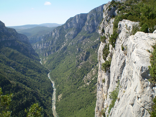
Verge Gorge is the deepest gorge in Europe located in a province
Provence- Alpes- Cote- D’Azur of France. Limestone cliffs of Verge Gorge
reach a height of 700 meters and it is about 12 mi (30 km) long. It is
locally known as Grand Canyon du Verdon. You can access the gorge from
the West from Lac de Ste Croix or Moistiers- Ste- Marie (see map on the
left). Road D952 will take you along the North Rim of the canyon, while
D71 road will take along the South Rim.
First humans settled the
region about 400,000 years ago. Many artifacts were found in the Grotte
de la Baume Bonne near a village of Quinson (West of Lac de Ste Croix).
The gorge is open to fishing, climbing, kayaking and rafting. A net
work of well marked trails of various lengths will allow you to explore
this beautiful geologic formation. Although at times you will need great
deal of stamina and attention to walk along narrow paths that are cut in
the walls of the canyon. If you want to cycle around the valley and
enjoy its splendid views you can take a road.
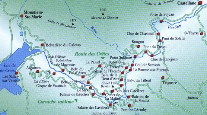
The Verdon rises near the Col d'Allos in the Trois Évêchés mountain
region and flows into the Durance after about 175 km near
Vinon-sur-Verdon. The most interesting stretch of its course is between
Castellane and the Galetas Bridge, just before the Lac de Sainte-Croix.
The Verdon Gorge largely defines the border between the departments of
Var to the south and Alpes-de-Haute-Provence to the north. The area is
divided into three sections:
The "Prégorges" between Castellane and
the bridge at Soleils
The gorge between the bridge and l'Imbut
The
canyon between l'Imbut and the bridge of Galetas
The gorge is between
6 and 100 m wide at the bottom, the opposite sides are between 200 and
1500 m apart and the depth varies between 250 and 700 m.
In the Triassic period, Provence sank and was covered by the sea. As
a result, various layers of lime (dead shells, etc.) were deposited on
the bottom. In the Jura, Provence was again flooded by a warm, shallow
sea, favoring the formation of powerful coral reefs.
In the
Cretaceous period, Provence rose and the sea retreated to what is now
the Alps. Only in the Tertiary were the Alps folded up. The resulting
limestone massifs from the Jurassic period determined the relief and the
valleys. During this time, the Verdon was also looking for a bed.
In the Quaternary, the Ice Age glaciers shaped the landscape. At the
end of the glaciation, the rivers resume their erosive activity. Due to
the melting of the ice, the amount of water was enormous: up to 3000
m³/s. These quantities made possible the deep cuts in the soft rock.
Before 1973, the village of Les Salles-sur-Verdon was located on the
site of today's reservoir, created by the construction of the
Sainte-Croix dam. It was completely destroyed just before the valley was
flooded and rebuilt elsewhere. Today it is one of the youngest communes
in France.
The gorge has been an official nature reserve since
May 7, 1990.
On July 10, 2006, the Conseil d'État decided that
the planned 400,000-volt high-voltage line of the Électricité de France
should not be built through the canyon. This ended a 23-year struggle
between various environmental and nature conservation organizations
committed to preserving the original gorge.
1905: First complete
crossing of the gorge by speleologist Martel
1929: Laying of the
foundation stone of the Castillon dam
1932: Suspension of
construction work
1936: A fire damages the dam
1948: Completion of
the Castillon Dam
1951: Completion of the Chaudanne Dam
1960:
Completion of the Esparron-Gréoux dam
1973: Flooding of the
Sainte-Croix reservoir
1973: Reconstruction of the flooded village of
Les Salles-sur-Verdon about 400 m away
1974: Start of electricity
production at the hydroelectric power station in Sainte-Croix
1975:
Quinson Reservoir flooded
On the water
Some of the Verdon Gorge can be navigated with
whitewater kayaks, in the lower reaches of the Lac de Sainte-Croix even
with normal rowing boats. The water discharge of the upper reservoirs is
uniformly fixed, at least during the peak tourist season of July and
August. In order to support water sports, such as white water swimming,
rafting etc., more water is released on two days a week (mostly Tuesdays
and Fridays). The outflow is then 10-16 cubic meters of water per
second, on the other days about 0.5 cubic meters of water per second.
There is a hotline for information about current water levels. In the
pre-season and post-season, on the other hand, water is discharged much
more irregularly, in some years up to 40 cubic meters per second for
weeks, in others only 0.5 cubic meters per second for weeks. With water
volumes of more than 2 to 3 cubic meters, inexperienced whitewater
swimming is advised against bathing in the current. Life is then at risk
due to unpredictable obstacles such as siphons, undermining and blocking
of wood.
Hike
Hiking in the more inaccessible regions of the
gorge is very popular and considered safe. The most famous hiking route
through the Verdon Canyon begins and ends in the middle of the canyon at
a vantage point from which it descends relatively steeply over
serpentines. It leads along the Sentier Martel (named after the first
traverseer Martel). The descent starts from the Route de Crête, at the
club house "La Maline". When you get to the bottom of the river, you
should head north at the fork in the road there and quickly follow the
path upstream. In the course of the almost six-hour hike - without the
possibility of a stop in between - the hiking trail leads constantly
uphill and downhill and down over some artificial ladders and stairs.
One of them (Brèche Imbert) is quite steep, descending 252 steps from a
viewpoint. Shortly before the end of the route, the path leads through
two consecutive tunnels, which are the only way to continue. The river
was originally supposed to be completely diverted here, but the project
was abandoned after the Second World War. The length of the first tunnel
is 110 m, that of the second 657 m.
Overall, this mountain hike
takes about five to six hours of walking time. There is another parking
lot at the end or starting point Point Sublime in the north. For the
return trip to the starting point, there is the option of taking a gorge
taxi or a public bus, which runs very rarely.
Climb
The Verdon
Gorge was one of the most important climbing areas in the 1970s and
1980s. In the 1970s, numerous exposed technical lines were climbed for
the first time, and in the 1980s climbers such as Patrick Berhault and
Patrick Edlinger were able to freely climb many of these routes. Even
today, there is still intensive climbing in the area.
further
activities
On the ring road around the Verdon Canyon there are always
vantage points towards the gorge, but also towards the lavender fields
for which the region is famous. Paragliders, hang-gliders and gliders
often circle over the gorge, weather permitting. The Pont de l'Artuby is
very popular with bungee jumpers. The gorge with its passes is also the
destination of many motorcyclists.