Location: Lozère and Gard départements Map
Area: 913 km²
Official site
The Cévennes National Park is a French national park created
on September 2, 1970, covering the natural region of the
Cévennes and located mainly in the departments of Lozère, Gard
and Ardèche. It therefore extends over two regions: Occitanie
and Auvergne-Rhône-Alpes. Its headquarters are at the Château de
Florac.
The Cévennes national park has several
particularities that set it apart from other French national
parks: it is the only one to be located in the middle of the
mountains and, with the national park of forests, one of only
two in mainland France whose heart is inhabited and exploited by
permanent residents (agriculture and hunting).
Its heart
is classified as a category II protected area by the World
Commission on Protected Areas of the International Union for
Conservation of Nature.
The park has also been recognized
as a UNESCO biosphere reserve since 1985.
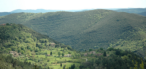
Location and general description
The only French mid-mountain
national park, the Cévennes national park is divided into two main
areas: the heart and the optimal adhesion area. There is also a
transition zone.
The national park covers 93,500 hectares and
includes 152 municipalities. It is therefore home to a significant
permanent population: 71,000 inhabitants live on this territory,
including some 600 in the heart. The inhabitants are mainly farmers.
The national park extends to the west over the Grands Causses, vast
limestone plateaus, to the east over the schistous Cévennes valleys, to
the north over the granite Mount Lozère. The levels of vegetation extend
from the Meso-Mediterranean level over all the south-west gorges, to the
subalpine level at Mount Lozère.
The Cévennes National Park is a mid-mountain territory made up of
four distinct geographical entities: the Aigoual massif, the Causse
Méjean with the Tarn and Jonte Gorges, Mount Lozère and the Cévennes
valleys.
The altitude of the park varies from 117 m in Anduze up
to 1,699 m at the Pic de Finiels, the highest point of the Park within
the granite bar of Mont Lozère. The granitic and schistose Montagne du
Bougès culminates at 1,421 m at the Signal du Bougès.
Mount
Aigoual has at its summit the signal of the Hort de Dieu or Tourette de
Cassini (1,565 m) which carries the meteorological observatory whose
summit of the tower culminates at 1,571 m.
The Pic de la Fageolle
or Pic Ferrège (1,555 m) dominates the south-eastern slope.
The
Aigoual massif also includes the summits of Lingas (1,445 m) and St
Guiral (1,366 m), the Espérou plateau (1,415 m) and the Col de Prat
Peyrot (1,380 m). The Sereyrède pass (1,300 m) is located on the
watershed line. Between the village of Valleraugue (elevation 300-350 m)
at the bottom of the valley and the summit, the drop of 1,250 m is one
of the highest in the Massif Central.
The gorges of the Tarn in
the north and the Jonte in the south are bordered by so-called
"serrated" cliffs plunging into subvertical walls to a depth of 500 to
600 m.
The south-eastern edge of the Massif Central has high
limestone plateaus, the Causses which rise between 700 and more than
1,200 m in altitude. These flattened expanses are cut by the deep gorges
of the rivers. The Causse Méjean is the highest, with an altitude of 800
m to 1,247 m at Mont Gargo.
The schistose slopes of the Cévennes,
steep and deeply shaped by a succession of greenhouses and narrow
valleys run over more than 1,000 m of drop from the Lozère heights
towards the Languedoc scrubland.
Above 900 m altitude is the
upper part of the Cevennes slopes along a line separating Gard and
Lozère in the Monts de la Lozère massif with a peak at 1506 m near the
Plateau de la Croix de l'Hermite and in the Aigoual massif at Mont
Aigoual at 1565 m. Less than 900 m above sea level, below the limit of
the chestnut zone, we find the landscapes of the lower Cévennes.