Location: 46 Rue du Ramstein, Baerenthal, Moselle department, Lorraine Map
The Ramstein Castle is a 13th century ruin located in the Moselle department in the town of Bærenthal, on a rocky ridge at a place called Schlossberg.
This castle is mentioned under the spellings Ramenstein and Ramestein in 1318.
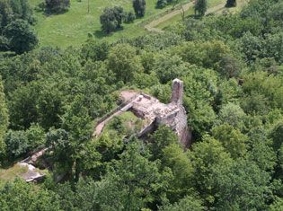
Château de Ramstein is a ruined medieval castle in Lorraine province of France. It was used to control strategic hill overlooking Zinselbach Valley below. Parts of the castle is cut in the rock cliff. Parts of the castle that stood above ground is largely destroyed. Nevertheless Château de Ramstein offers a great view of the hills around the citadel. To get to the upper platform you would need to climb several staircases and make your way through rooms and halls cut into natural rock. Château de Ramstein was constructed in the late 13th century (1292- 93) by the lords of Falkenstein by the orders of the bishop of Strasbourg. It stood on the border between the bishopric of Metz and Strasbourg and protected borders of Strasbourg.
During the 14th century owners of Ramstein Castle became looters knights. Wernher Nettew Ramstein who came into possession of the citadel in 1317 became particularly famous with his brutal and aggressive actions. He turned his citadel into a base for bandits and thieves that spread fear and havoc among the locals. Lord of Lichtenberg summoned Lord of Ramstein to answer for his misdeeds, but he didn't show up. Troops of the bishop of Strasbourg and their allies from Berne launched a surprise punitive attack against these bandits. They besieged and captured Château de Ramstein in 1355. Castle was abandoned and left in disrepair. In the 15th century castle ruins were divided between Count Louis V of Lichtenberg and Lords of Bootsheim.
Between World Wars French government extended Maginot Line defenses to the region of the fortress. French military engineers dug two underground passages underneath its ruins in 1936. Château de Ramstein itself was acclaimed as a protected site in 1938 by the French Ministry of Culture. Local population used these tunnels during military hostilities in the early 40's and again in winter 1944- 45. Today these historic structures are closed as a means of protection of local colonies of bats. Ramstein Castle itself is owned by a commune of Baerenthal (since March 4, 2008) that signed a lease for a term of 18 years.
Historical controversies and untruths
The
construction of the castle, in the thirteenth century, is sometimes
attributed to the Lord of Falkenstein.
The castle would have been
built in 1292, it is indeed from this date that the embossed stones
- absent on the site - were abandoned.
The stately home is often
confused with a dungeon of which there is no trace.
Special
features still visible
Ramstein castle is built on a rocky
platform of variegated sandstone (or Buntsandstein) 270 m long and 6
m wide on average. The rocky ridge provides the support and
constitutes the main element of defense of the fortification by its
height and verticality.
We can still distinguish the remains
of the stately home, the verticality of which is visible from afar,
as well as doors, stairs, galleries and two troglodyte chambers
carved into the rock.
There is no vestige of a possible
dungeon.
A mushroom-shaped sandstone rock is located in front
of the ruins of the old castle.
Maginot Line
Below, we can
see two underground entrances that communicate with each other. They
were dug in 1936 by the military engineers to make a supply depot
for the Maginot line. These facilities were used as shelter by the
population during the fighting in the winter of 1944-1945. This site
is currently closed by gates because it hosts protected bats.
Status
Ramstein castle is listed in the topographic inventory
of the Lorraine region.
The site has been classified since
1938 under the legislation on historic monuments.
Access
Located at the exit of Bærenthal towards Mouterhouse, you have to
follow the rue de Ramstein to access the ruins. Continue straight
ahead towards the forest house. A car park has been set up by the
National Forestry Office on the left at the entrance to the forest.
A path leads to the ruins in ten minutes. There is a remarkable
viewpoint over the village of Bærenthal and the Zinsel valley.