Location: d'Ivry-la-Bataille, Eure département Map
Constructed: 10th- 13th century
Château d'Ivry-la-Bataille is situated in d'Ivry-la-Bataille,
Eure département of France. This medieval citadel was constructed in
the end of the 10th century by Alberede, wife of Raoul d'Ivry.
Military fortress of Château d'Ivry-la-Bataille was designed to
protect this strategic region of Normandy that was a site of many
battles between the French and the invading armies from England. It
became a valuable possession during the Hundred Years War. In 1418
it was captured by the English after a siege that lasted for 40
days. In 1424 the French managed to retake the fort, but only
briefly. The English soldiers took the castle again, but instead of
defending they destroyed upper stories of the buildings so it
couldn't be used by the enemy. Nothing but ruins were left on this
site as it was became a quarry site for local people. Despite its
ruined condition historians believe that d'Ivry- la- Bataille was an
expiration for construction of the Tower of London.
Originally the castle was called Ivry- la- Chaussee. It changed on
March 14, 1590 when a famous battle was fought in its vicinity
between French king Henry IV and forces of the Catholic League. By
the time of the battle the castle was reduced to ruins, but its was
still a prominent local feature.
The castle occupies a promontory, north of Dreux, on the edge of the
plateau in strong projection which dominates from 70 m the valley of the
Eure and the town of Ivry-la-Bataille, constituting a visual control
point of the surrounding country. The town, formerly Ivry-la-Chaussée,
whose name Ibriacum appears in documentation in the eleventh century, is
related to the famous battle of Ivry which opposed the future Henry IV
to the troops of the Catholic League, the March 14, 1590.
Due to
its location, this fortress defended the south-eastern borders of the
Duchy of Normandy, a strategic stake between the crown of France and
that of England, on the borders of Normandy and Île-de-France, facing
the Pays Chartrain . He watched in particular the bridge which spans the
Eure at this place. This lock on the Eure valley, is part of the line of
defense where we find the castle of Saint-Clair-sur-Epte, that of
Gisors, etc.
Researchers believe that the site could have been occupied since
ancient times, in correlation with an ancient road linking Évreux to
Paris. Archeology has not yet confirmed this hypothesis.
At the
end of the 10th century, Richard I of Normandy, given the strategic
importance of this important frontier place, entrusted it to his
half-brother Raoul d'Ivry. The latter undertook the construction of a
large masonry castle structure around the year one thousand (around
960), on the site of a Carolingian aula, with the supposed help of the
architect Lanfroy. Orderic Vital in the twelfth century, says that
Aubrée had a “famous, enormous and very fortified tower” erected (turris
famosa, ingens et munitissima). The fortification would have been
ordered by Aubrée (Alberède), wife of Raoul, to a certain Lanfred,
architect who had built the castle of Pithiviers. The keep built around
the year one thousand is, with the towers of Rouen and Avranches, among
the first stone fortifications to appear in Normandy.
Around
1029, Hugues d'Ivry, Bishop of Bayeux, who succeeded his father Raoul on
his death around 1015 as Count of Ivry, revolted against Robert I the
Magnificent and armed the castle with a French garrison. But the Duke of
Normandy recovers the castle and installs a ducal garrison there. Hugues
will have to go into exile for a while before being able to return to
grace. In 1040, Alberède, natural daughter of Hugues d'Ivry, undertook a
new campaign of works on the castle (that of the second third of the
11th century). This character quoted by Guillaume de Jumièges is very
real, as opposed to the semi-legendary one of Orderic Vital. Around
1050, a new ducal takeover with William the Conqueror, the title of
Count of Ivry disappeared. The castle was then controlled directly by
the Dukes of Normandy. Robert II Courteheuse cedes it, around 1089, to
Guillaume de Breteuil, great-grandson of Raoul.
In 1119, Louis VI
the Fat set fire to the castle. In 1177, the tower was handed over to
Henry II Plantagenet. In 1194, Philippe Auguste seized the fortress,
during a military campaign in the region. In 1195 following the Treaty
of Issoudun, the Château d'Ivry was attached to the royal domain.
During the Hundred Years War, in 1419, commanded by Pierre
Dorgessin, the fortress capitulated in May9 to the English after a siege
of 40 days. The French, headed by Géraud de la Pallière, a Gascon
gentleman in the service of Charles VII, retook it during the summer of
1423 and kept it for a year, using it as a base for raids and worrying
Évreux. The English, believing that the recovery of Ivry was becoming a
priority, besieged the castle again in June 1424, led by the Duke of
Bedford. The place capitulated on July 5, and was returned to them on
August 15. Unable to maintain a garrison there, the English undertook
the destruction of the upper parts, preferring to destroy the fortress
rather than see it fall back into French hands. In 1449, the Constable
Jean de Dunois definitively made himself master of the town of Ivry. In
1456, in a confession, mention is made of the state of ruins of the
castle “by the occasion of the war […] knocked down and demoulded and
put in total destruction. ".
The castle, ruined by the English
and having lost all strategic interest, is only mentioned in the
estimation of the domain. In 1547, Diane de Poitiers bought the barony
of Ivry. In 1567, the castle "which is said to have been demolished by
the English during the reign of King Charles VII" was assessed with the
warren that surrounds it. In 1740, in an estimate drawn up by an expert
by the name of Mouchet, the castle was “drawn to nothing […] it consists
only of a few remains of building debris which cannot be used. ".
After its destruction and leveling, the remains, which became a
stone quarry and filled with earth, gradually fell into oblivion. Around
1960, only a wooded hill from which a few sections of walls emerge still
marks the location of the fortress. It was in 1968 that Robert Baudet, a
cabinetmaker in Ivry, undertook, with the archaeological club he had
just created, the clearing of the substructures. After twenty years of
work, the original ground reappears and the ruins of the castle come out
of the ground and will allow in 1990 its classification as historical
monuments. The castellologist Jean Mesqui, the English archaeologist,
Edward Impey, or the historian of Normandy, Lucien Musset, recognize the
interest of the work and publish the first analyzes of the remains,
focusing on its oldest parts dating of the year one thousand. From 2007
to 2010, new archaeological excavations, and the re-examination of the
ruins, made it possible to clarify the history of the castle.
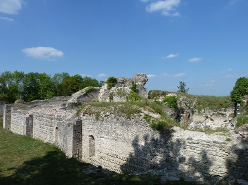
Three parallel ditches, as well as a fourth deeply cut into the rock
on the western flank, isolated the castle from the rest of the plateau;
the whole constituting a defensive position in barred spur. A flanked
enclosure later doubled the defense. On its eastern flank, the site
dominates the village from a height of about fifty meters, which is
located at the foot of the hill, along the Eure, around the bridge
controlled by the castle.
Begun around 960, the primitive
construction is an aula (Carolingian princely hall), a large rectangular
construction measuring 32 × 25 meters on each side. At the base of the
3-metre-thick walls, there is a herringbone structure characteristic of
Carolingian constructions, as well as the use of brickwork on a few
elements, including a buttress. At the end of the 10th century, work
turned it into a dwelling-keep, with buttresses, which a priori rose on
two levels and included a so-called chapel of Saint-Ursin and a turret.
This imposing ensemble is due, according to legend, to the architect
Lanfred (or Lanfroi), who was then beheaded by order of Alberède, wife
of Count Raoul.
In the course of the 11th century, the first
level of the original castle was rendered blind by the addition of a
considerable mass of embankments. Ivry then presents a rectangular plan
with in the northeast corner, the apse of the chapel. Such work was
probably not undertaken without the approval of the Duke of Normandy,
and one could see there the work of William the Conqueror, knowing that
there is a clear resemblance between the tower of Ivry and that of
London (around 1070), the first would then have served as a model for
the second. After the capture of Ivry in 1194 by Philippe Auguste, he
razed the western half of the tower and raised the preserved part,
transforming it into a kind of "dungeon" which thus lost its residential
function, transferred to the barnyard. located further south. The castle
will be further refurbished before its capture in 1429 by the troops of
Henry V with the addition of a châtelet in front of the main access to
the fortress, and probably in the 14th century, reinforced in its
northeast corner by a large tower .
Today, all that remains of
the square keep, planted at the end of the 11th century opposite the
royal domain1, is only the first level.
The visible parts, as well as the ground of the parcels on which they
are located, likely to contain vestiges are classified as historical
monuments by decree of February 8, 1990.
Visit
Property of the
municipality, the site has been the subject of major excavations and is
freely accessible all year round.