Area: 406 km²
Kellerwald-Edersee National Park (Naturpark Kellerwald-Edersee) is a nature reserve in the Hesse region of the central Germany. Kellerwald-Edersee National Park covers an area of 406 km² protecting the area around the Edersee lake. The park contains many hiking trails including Kellerwaldsteig that is a loop trail that is 167 km long and Urwaldsteig Edersee ("Virgin Forest Trail") that reaches 68 km. The terrain of Kellerwald-Edersee National Park area is uneven and hilly although it is not very high. The highest point is Wüstegarten that reaches 675 meters.
The best way is by car or by bike and train.
Kurhessenbahn
trains run to the Kellerwald on the RB39 / (KBS 621)
(Wabern-Fritzlar-Bad Wildungen) and RB42 / (KBS 622) (Marburg
(Lahn)-Frankenberg (Eder)-Herzhausen (National Park
station)-Korbach-Willingen railway lines). (Upland) Brilon)
Of
course there are also buses. Information on public transport in the
region can be found on the NVV website.
The best way to discover the varied nature of the region is on foot.
But the mountains can also be explored by bike. However, there is no
comprehensive regional cycle route network for the entire region. In the
Edersee area, however, there are some well-signposted circular routes.
The Edersee cycle path, which leads around the lake, is also located
here.
Rental stations for e-bikes can be found: in the
Reinhardshausen foyer, on Lake Edersee, in Frankenau and Bad Zwesten and
at the national park facilities.
Kellerwald-Edersee National Park and others with the National Park
Center in Herzhausen, the Peterskopf vantage point and the Quernst
chapel (also with a view).
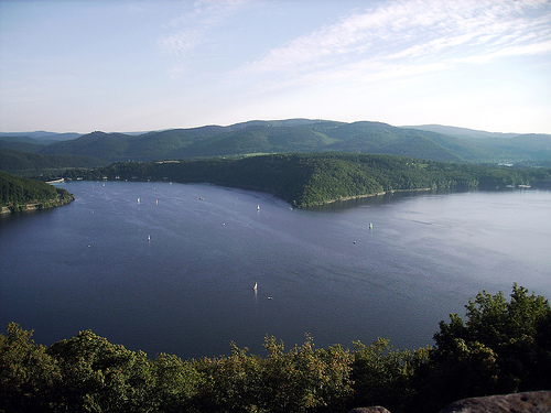
Edersee with dam wall, Waldeck Castle and
wildlife park with griffin watchtower
Princess garden near Jesberg.
There is almost nothing left of the former pleasure garden, which was
laid out between 1723 and 1753 in today's Jesberg state forest. The
forest has already largely reclaimed the gardens. However, the imposing
Princess Garden oak, which was part of the garden, is worth seeing.
Location: At 50° 58′ 59″ N 9° 10′ 9″ E about 2km south of Jesberg. The
long-distance hiking trail X 16 (Lulluspfad) leads past the remains of
the facility.
Altenburg mountain with observation tower and
archaeological circular hiking trail to the Celtic Wall. The mountain to
the east of Bad Zwesten no longer belongs geographically to the
Kellerwald, but it still belongs to the region in terms of tourism.
Peterkopf viewing platform with cable car with E-On hydroelectric power
information center at the Waldeck pumped storage power plant near
Hemfurth
Old Hutewald "Paradise" and "Halloh" near Albertshausen
monasteries, castles and palaces
Haina Monastery - The monastery
church and cloister can be visited. Haina(Monastery) official site
Jesberg Castle The facility is located on a hill in the middle of the
town. The keep with the viewing platform of the restored ruins can be
climbed (according to Wikipedia: in the summer months between April and
October daily from 9 a.m. to 8 p.m.; no admission).
Hiking: The national Kellerwaldsteig opens up the entire mountain
range in large loops.
Mountain biking: The Kellerwald Bikemarathon
takes place every spring in Gilserberg.
The Kellerwald-Edersee
Nature Park is located in the northern Hessian districts of
Waldeck-Frankenberg and Schwalm-Eder between Waldeck and Vöhl in the
north and Gilserberg in the south. Its westernmost point is to the
west of Frankenau, the easternmost near Bad Zwesten. The communities
Bad Wildungen and Edertal lie on its northeastern edge, Jesberg in
the southeast and Haina and the Gemündener district of Herbelhausen
in the southwest.
The nature park to the southwest of Kassel
(mean distance approx. 40 km as the crow flies) roughly corresponds
to the size of the Kellerwald. Within its boundaries lie - in
addition to some districts of the aforementioned cities and
communities, with the core cities of Bad Wildungen and Frankenau
belonging entirely to the park - the Edersee and the Affolderner
See. In the north it extends over the Edersee, in the south into the
Upper Hessian threshold with the Hemberg ridge bordering the
Kellerwald to the south.
The 57.24 km² Kellerwald-Edersee
National Park extends south of the Edersee in the northern part of
the nature park. North-northeast of the national park on the south
bank of the reservoir is the Edersee wildlife park with the Edersee
wildlife park Greifenwarte and the Fagutop cellar forest information
center.
The lowest point of the
Kellerwald-Edersee Nature Park is in Affoldern in the Edertal below
the barrage of the Affolderner See at 194 m above sea level. NHN,
the highest point on the desert garden (675.3 m), which, together
with the Hunsrück and Sauklippe, forms the Keller mountain ridge
(also known as the Hoher Keller) in the southeast of the Kellerwald.
The best-known, but not necessarily the highest mountains in the
Kellerwald-Edersee Nature Park include all of the “six hundred” -
sorted by height in meters (m) above sea level.
Desert garden
(675.3 m) - with Kellerwald Tower - the highest mountain in the
Kellerwald-Edersee Nature Park and in the Kellerwald
Hohes Lohr
(656.6 m) - with the Hohes Lohr telecommunications tower
Great
Aschkoppe (639.8 m)
Hunsrück (635.9 m)
Traddelkopf (626.4 m) -
highest mountain in the Kellerwald-Edersee National Park
Winterberg (616.6 m) - southern foothills of the Great Aschkoppe
Auenberg (610.7 m)
Kleine Aschkoppe (606.8 m) - western foothills
of the Great Aschkoppe
Ahornkopf (604.1 m) - southwest foothills
of the Traddelkopf
Big head (603.7 m)
Jeust (585.0 m)
Valley passage (566.1 m)
Quernst (approx. 545 m) - northern
foothills of the valley with the ruins of the Quernstkirche (at 535
m) and Quernst chapel
Ermerod / Peterskopf (approx. 539.2 m /
506.6 m) - with two upper basins of the Waldeck pumped storage plant
Homberg (518.5 m) - with a lookout tower on the Homberg
Hundskopf
(470.6 m) - the highest point on the Upper Hessian threshold
Schlossberg Waldeck (see here for the height) - with Waldeck Castle
Rabenstein (439.3 m) - southern flank of the Rabensteinpforte
Uhrenkopf (approx. 405 m) - good view of the Edertalsperre
Pulpit
(399.3 m) - good view of the Waldecker Bay of the Edersee
The rivers that frame the Kellerwald-Edersee
Nature Park, or that arise and run in it, include (Eder and Wohra
tributaries viewed downstream; their tributaries with their estuary
location / area).
Large-scale nature conservation project in
the Kellerwald region
The large-scale nature conservation project
Kellerwald Region has been running in the nature park since 2005. It
was extended from 2015 to 2018. The project carried out by the
Federal Agency for Nature Conservation deals with the "establishment
and safeguarding of parts of nature and landscape that are worthy of
protection and that are of national significance". In the “Funding
program for the establishment and safeguarding of parts of nature
and landscape worthy of protection with national representative
importance”, the federal government participates in nature
conservation projects which, in an international comparison,
exemplify the commitment of nature conservation in Germany. The
major nature conservation project was approved at the end of 2005.
Six million euros were available for implementation by 2015. In the
planning phase or phase I from 2005 to 2008 the first task was to
draw up a maintenance and development plan for the nature park and a
socio-economic study. This was followed by the approval process for
this plan. In the following implementation phase or phase II from
2009 to 2015, the focus was on implementing the plan. The extension
phase from 2016 to 2018 focuses on the forest and the protection of
the nature park. A system of protected areas should ensure that the
project goals are sustainably secured. In the large-scale nature
conservation project, land was purchased, red spruce forests were
converted into deciduous forests, forest areas were made a total
reserve, water renaturation and maintenance measures on special
grassland areas. In the grassland areas, protective measures were
carried out in heathland and poor grassland. Special species
protection measures were implemented for the whitefly. In addition,
extensive public relations work was carried out in the area,
including information paths, stationary and mobile exhibitions.
The nature conservation project in the Kellerwald region has been running in the nature park since 2005. It was extended from 2015 to 2018. The project carried out by the Federal Agency for Nature Conservation deals with the "establishment and safeguarding of parts of nature and landscape that are worthy of protection and are of national representative importance". In the "funding program for the establishment and safeguarding of parts of nature and landscape that are worthy of protection and are of nationally representative importance", the federal government is involved in nature conservation projects which, in an international comparison, demonstrate the commitment of nature conservation in Germany in an exemplary manner. At the end of 2005, the major nature conservation project was approved. Six million euros were available for implementation by 2015. In the planning phase or phase I from 2005 to 2008, it was initially about the creation of a care and development plan for the nature park and a socio-economic study. This was followed by the approval process for this plan. The following implementation phase or phase II from 2009 to 2015 was about the implementation of the plan. The extension phase from 2016 to 2018 focuses on the forest and the protection of the nature park. A sustainable safeguarding of the project goals is to be achieved by a protected area system. In the large-scale nature conservation project, land was purchased, forest conversion from red spruce forests to deciduous forests, ceding of forest areas to a total reserve, water body renaturation and maintenance measures on special grassland areas. In the grassland areas, protective measures were carried out in heathland and nutrient-poor grassland. Special species protection measures have been implemented for the Penny Carnation. Extensive public relations work was also carried out in the area, during which information paths, stationary and mobile exhibitions were created.
Many hiking trails lead through the Kellerwald and Kellerwald-Edersee Nature Park, including the Kellerwaldsteig, a 156 km long circular hiking trail that connects the mountains, villages and valleys of the Kellerwald-Edersee Nature and National Park. Around the Edersee leads the approximately 68 km long Urwaldsteig Edersee, which essentially runs through the national park with its beech forests and the dry oak forests on the northern slopes. There are also several educational and adventure trails on various themes in the Kellerwald-Edersee Nature Park.