Area: 4410 km ²
The Schleswig-Holstein Wadden Sea National Park is a national park
in the Schleswig-Holstein part of the Wadden Sea of the North Sea.
The state parliament established it with the National Park Act of
July 22, 1985 effective October 1, 1985 and expanded it
significantly in 1999. Together with the Lower Saxony Wadden Sea
National Park, the Hamburg Wadden Sea National Park and the parts of
the Elbe estuary that are not subject to nature conservation, it
forms the German part of the Wadden Sea.
The national park
stretches from the German-Danish sea border in the north to the
mouth of the Elbe in the south. In the North Frisian part it
includes the mud flats around the Geestkern and Marschen islands and
Halligen. There the mudflats are sometimes 40 kilometers wide.
Further south are mud flats, where there are mainly larger
sandbanks. In addition to the plants and animals that are typical
for the entire Wadden Sea of the North Sea, there are particularly
many porpoises, shelducks and seaweeds in the Schleswig-Holstein
part.
With an area of 4410 km², it is by far the largest
national park in Germany and the largest national park between the
North Cape and Sicily. 68% are submerged and 30% periodically dry
out. The land part consists mostly of salt marshes. Since 1990, the
national park, together with the North Frisian Halligen, has formed
the UNESCO-recognized Schleswig-Holstein Wadden Sea and Halligen
Biosphere Reserve. Together with the Lower Saxony and Dutch Wadden
Sea areas, the Schleswig-Holstein Wadden Sea was registered as a
UNESCO World Heritage Site in 2009. The Hamburg Wadden Sea has
belonged to this network since 2011 and the Danish National Park
Vadehavet since 2014.
The national park covers the
Schleswig-Holstein coastal area of the North Sea from the Danish border
in the north to the mouth of the Elbe in the south. In the northern area
(up to around Amrum) the national park border runs along the twelve-mile
line, south of it around the three-mile line. On the land side, it runs
150 meters off the coast in the Wadden Sea. Sea dikes and the immediate
forelands of the dikes are not part of the national park, and bathing
beaches are also largely excluded from the protected area. The inhabited
areas in the sea are also excluded from the national park, including the
five German North Frisian islands and the large Halligen islands:
Langeneß, Hooge, Gröde, Oland and Nordstrandischmoor. Part of the
national park are uninhabited islands, Halligen and sandbanks such as
Trien, Blauort or the North Frisian outer sands. According to the
classification of Germany's main natural spatial units, the area of the
national park belongs to the "Schleswig-Holstein Wadden Sea, Islands and
Halligen" unit in the Schleswig-Holstein Marshes group and to the main
unit German Bight.
The national park can be divided into two
areas. In the north between the Danish border and the Eiderstedt
peninsula is the North Frisian part, on the south coast of Eiderstedt up
to the mouth of the Elbe is the Dithmarscher part. The North Frisian
Wadden Sea belongs together with the Danish Wadden Sea to the northern
Wadden Sea of the North Sea. It is shielded from the open sea by the
North Frisian islands and Halligen. The islands were mainly formed from
mainland areas that were separated from the land due to catastrophic
floods. The Wadden area is more sheltered, the transition between the
Wadden Sea and the sea is often clearer, since the first is on the east
side of the large islands, the second on the west side. There are no
large estuaries, and the tide difference is relatively small at less
than two meters. Geest cliffs from the Ice Age can only be found in the
northern Wadden Sea, so that the greatest differences in height also
occur here on the coasts in what is actually a very flat area. The
Dithmarscher part and the south coast of Eiderstedt between the Elbe and
Eider estuaries form part of the central Wadden Sea. A tidal range of
more than three meters largely prevents the formation of islands. A few
sandbanks rise out of the sea, only Trien is high enough, and thus safe
from storm surges, to allow vegetation that is sensitive to salt water.
In comparison to the geologically similar East Frisian Islands of the
southern Wadden Sea, however, Trisch is much smaller and younger. All
attempts by human residents to fortify the island have failed. Due to
several large estuaries, the salinity in the central Wadden Sea is lower
than in the rest of the Wadden Sea and is subject to greater
fluctuations.
The
national park is divided into two zones that correspond to different
levels of protection. Zone 1 forms the core of the protected area. The
162,000 ha zone covers a good third of the national park. It consists of
twelve larger spatial units, each of which has salt marshes, silt, mixed
and sandy tidal flats, flat and deep areas that are permanently under
water (sublitoral) and tidal creeks. In addition, there are smaller
units around particularly sensitive areas such as seal banks or the
breeding colonies of seabird species, places where many migratory birds
moult, as well as geomorphologically significant areas with almost
natural surface structures. Zone 1 is basically closed to the public,
the only exceptions are mudflat areas directly adjacent to the coast for
mudflat hikers, routes for guided mudflat hikes and fishing. To the
south of the Hindenburgdamm on the land side of Sylt, human use is
completely excluded within protection zone 1 ("zero use zone"). This
occupies 12,500 ha, of which about 3,500 ha are permanently covered by
water.
Zone 2 forms a so-called "buffer zone" around zone 1, in
which sustainable use is made possible. In protection zone 2 is the
small whale protection area west of the Sylt coast, which has a size of
124,000 hectares. This area is an important breeding area for harbor
porpoises, whose population in the North Sea has declined by 90% in the
20th century. While uses such as bathing, sailing or traditional shrimp
fishing are still possible in the area, it is intended to prevent
international industrial and gillnet fishing, jet skis, ship speeds
exceeding twelve knots, military activities and resource exploitation
(sand, gravel, gas or oil).
The North Sea coast is flat; the sea
floor drops only a few centimeters per kilometer. Twice a day the tide
carries sand, clay and silt into the Wadden Sea area. The tidal range in
the Schleswig-Holstein Wadden Sea is between 1.5 and 3.7 meters,
increasing from north to south: the lowest tidal differences are on the
north coast of Sylt, the highest in southern Dithmarschen. Everywhere in
the Wadden Sea, the time it takes for the water to flow is only about
85% of the time it takes for the water to run off again. The current is
therefore stronger when the water rises, and the ebb does not have the
strength to carry away the sediments washed up by the tide.
More
than two thirds of the area of the national park are occupied by areas
that are constantly under water (sublittoral), 30% of the mud flats that
are dry at low tide and flooded at high tide (eulittoral). The rest are
land areas (supralitoral) that are only submerged under special
circumstances. The water areas consist on the one hand of the seaward
part of the park, on the other hand of larger tidal currents such as the
Lister Deep, the Heverstrom, the Purrenstrom, the Wesselburener Loch or
the Piep. Directly in front of the Wadden Sea there is a constant strong
current from south to north, coming from the southern North Sea and
continuing to the Norwegian Channel. Since the current carries the
estuary waters of large European rivers such as the Rhine or Elbe, the
salinity is 20-30 psu below that of the sea, but still above that of
estuaries.
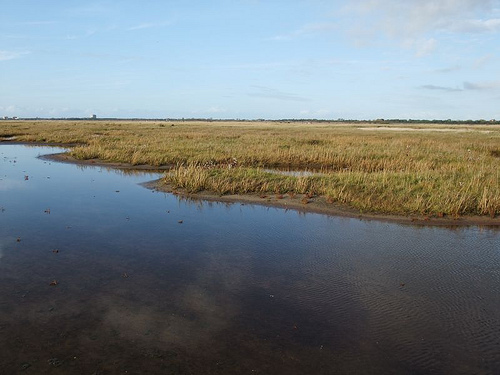
Since inhabited areas are not part of the national
park, the land areas consist almost entirely of salt marshes, with a
small remainder of sandbars and dunes. The salt marshes cover an area of
over 10,000 hectares, of which 70% were formed on the mainland in the
protection of tallows, 10% are on the leeward sides of the islands and
the rest have formed around the Halligen. Between 1988 and 2001, the
area of the salt marshes expanded by around 700 ha. Largely natural,
unused salt marshes are mainly found off the islands; on the mainland,
this only occurs off Schobüll and Sankt Peter-Ording.
As in the
entire Wadden Sea, the climate is Atlantic, always humid and warm
temperate. Strong westerly wind drift and the heat storage capacity are
determining factors, which ensure frequent strong winds, but have a
balancing effect on the temperatures, so that the area enjoys cool
summers (July: 14.5 °C) and mild winters (January: 1.8 °C). learns.