Location: Stecklenberg, Saxony- Anhalt Map
Constructed: 12th century
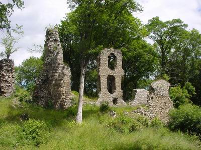
Ruins of medieval Stecklenburg
Castle are located near Stecklenberg, Saxony- Anhalt region of Germany.
It was constructed in 12th century.
The ruins of the Stecklenburg are located on the north-eastern slope of the Burgberg (356.1 m above sea level), south of Stecklenberg (district of the city of Thale), a northern branch of the Ramberg massif. The ruins of the two-part Lauenburg Castle are on the average about 630 m to the southwest.
The hilltop castle was built in the 11th
century on the remains of an older castle complex. In the 12th century
it was destroyed in a battle but rebuilt. The owners were the Knights
von Stecklenberg, mentioned in the 12th and 13th centuries, whose
descendants probably emigrated to the Baltic States, where Henricus de
Stackelberg was first mentioned in Riga in 1306. The monastery in
Halberstadt became the new owner of the Mecklenburg in 1281.
The
Mecklenburg region was inhabited until the beginning of the 18th
century. Afterwards, some of the castle's buildings such as the brewery
and the castle chapel were demolished. It became a complete ruin and
served as a quarry. It was saved from complete destruction by the
objection of the then chief forester von Thale, who was committed to
preserving the structure.
The castle ruin Stecklenburg is a protected monument and a popular excursion destination. Some walls of residential buildings and the remains of the keep have been preserved.