Location: Lörrach, Baden-Württemberg Map
Constructed: 11th century by Lords of Rötteln
Rotteln Castle is a ruined medieval citadel located in Lörrach, Baden-Württemberg region in Germany. Rotteln Fortress was constructed in 11th century by the orders of Lords of Rötteln. Rotteln Castle was badly damaged during Thirty Years' War then the citadel was occupied by the Imperial and Swedish forces. The final blow came during another European was that became known as Franco- Dutch War. In 1678 French Marshall Crecque destroyed its military fortifications. The ruins of Rotteln Castle were left abandoned.
Rötteln Castle
was first mentioned in a document in 1259, when Counts Rudolf and
Gottfried von Habsburg drew up a list of their fiefs from the
Murbach Monastery, which also included the castrum de Rötelnhein.
The Habsburgs had passed the castle on to the Lords of Rötteln as an
after-fief. This noble-free sex has been documented since 1102/03
and was wealthy in the southern Breisgau and there especially in the
valleys of the Great and Small Meadows. Rötteln is also the name of
a hamlet near the castle, which was mentioned in a document as
raudinleim as early as 751. The noble family could also be named
after this hamlet and is therefore no proof that the castle existed
in the early 12th century. Structural evidence also gives no clear
indication of the castle's construction; the keep, dated from the
middle of the 12th to the beginning of the 13th century, suggests
that it was built well before 1259; parts of the palace appear to
have been built around 1200.
The lords of Rötteln were
mentioned in documents more frequently in the early 13th century and
obtained high offices: Walther von Rötteln became canon in 1209,
later cathedral provost in Constance and in 1213 bishop of Basel.
After his deposition in 1215, he returned to the Konstanz cathedral
chapter. His brother Lüthold (I.) also embarked on a spiritual
career and was also Bishop of Basel from 1238 to 1248. In the first
half of the 13th century, between the secular lords, there was a
division of property between the brothers Konrad and Dietrich: While
Konrad continued to name himself after Rötteln, Dietrich apparently
moved to Rotenberg Castle near Wieslet and named himself after her.
Konrad von Rötteln probably had another castle built near Schopfheim
in the middle Wiesental and elevated the place to town. He was
married to a daughter of Count Ulrich von Neuenburg and had three
sons, of whom Lüthold II entered the Basel cathedral chapter, while
Otto and Walter, who died early, administered the Rötteln reign.
In the time of the 13th and early 14th centuries, when the
family became more clearly evident in the documents and provided two
Basel bishops, several expansions of the castle probably took place
South tower erected. Recent studies have also shown that at least
parts of the curtain wall around the lower castle date from the 13th
century and thus possibly from the time of Lüthold I or Konrad.
At the beginning of the 14th century, another Röttler, Lüthold
II, was about to be appointed bishop of Basel; twice he was elected
by the cathedral chapter, but both times the pope chose a different
candidate, which the second time triggered a multi-year bishops'
dispute, at the end of which Lüthold and his party were defeated.
During the bishop's dispute, Lüthold had to take care of the Röttler
succession: his brother Otto had probably died around 1305, Otto's
son Walter (III) shortly afterwards, either in 1310 or 1311. Otto's
daughter was with Margrave Rudolf von Hachberg-Sausenberg married,
who initially took over the administration of the Röttel property
together with Lüthold. However, Rudolf died in 1313 and Lüthold had
to take over sole management until he bequeathed all of his property
to his great-nephew, Rudolf's son Heinrich von Hachberg-Sausenberg,
in December 1315. Lüthold II died on May 19, 1316 and with him the
Röttler lords died out in the male line. The property and castle
came to the Margraves of Hachberg-Sausenberg.
The Margraves of Hachberg-Sausenberg were a branch of the Margraves of Hachberg, who by dividing the inheritance between Heinrich III. and Rudolf I at the end of the 13th century. The seat and namesake of this branch was the Sausenburg east of Sitzenkirch. For the Sausenbergers, the Röttler legacy meant a significant increase in power, which probably tripled their area of rule. As a result, Rötteln Castle became the focus of an enlarged aristocratic rule: the Sausenbergers probably moved to Rötteln before 1317, and the name of the inherited castle and lordship found its way into the names of the margraves.
Possibly as a result of inheritance disputes over
the Röttler rule, the castle was besieged in autumn 1332: One of the
margraves of Hachberg-Sausenberg had stabbed the Basel mayor,
probably Burkard Wernher von Ramstein, whereupon a Basel army moved
in front of the castle, but she did not conquered: The conflict was
then settled through mediation by the Basel landed nobility. It is
controversial whether the Basel earthquake in 1356 caused damage to
the castle. Jürgen Krüger affirms this due to the damage to the
Basel Minster and assumes major damage, from which only the solidly
built keep could have been spared. Werner Meyer and Werner Wild
point out, however, that the castle was not mentioned as destroyed
or damaged by contemporary chroniclers and therefore assume at most
minor damage.
Under Margrave Rudolf III. the parish church in
Rötteln was expanded, and at Rötteln Castle, as it were, increased
construction activity is assumed, although its scope is not
completely clear. However, in Rudolf's time, among other things, a
summerhus, probably located near the Palas and inhabited in the
summer months, and a Söller on the southern tower appear in the
documents. For a long time it was assumed that the outer bailey was
only built under the Margraves of Hachberg-Sausenberg, but recent
excavations suggest that at least parts of it were built during the
Röttler lords. Should the outer bailey fall into the
Hachberg-Sausenberg era, Rudolf III would be. been a likely builder.
A second, outer wall ring around parts of the main castle is also
dated to the 14th or 15th century; a second cistern in the main
castle is mentioned for 1420, and there seems to have been another
one in the outer castle. Through the purchase of the Neuenstein
estate - located between the Middle Wiesen- and Wehratal - Rudolf
was also able to enlarge his territory; In 1403 King Ruprecht
granted the town of Lörrach, not far from Rötteln Castle, market
rights. There was not yet a city elevation; The only town in
Rudolf's margraviate remained Schopfheim, the administrative center
was the Röttler Burg. Rudolf III. was also responsible for another
significant historical testimony: Probably between 1396 and 1428
various scribes at the court of the margrave wrote the Rötteler
Chronik, a family chronicle of the margraves of
Hachberg-Sausenberg-Rötteln.
Rudolf's son, Margrave Wilhelm,
began to turn away from the ancestral lands on the Upper Rhine;
Wilhelm was often on a diplomatic mission and held positions such as
that of governor at the Basel Council or Austrian governor in
Sundgau, Alsace, Breisgau and the Black Forest. He only spent a
short time at Rötteln Castle, where an official administration
headed by a bailiff administered the margraviate. In the middle of
the 15th century, however, Wilhelm was heavily in debt, with some
costly feuds of his father Rudolf III. may have played a role, and
handed over the rulers of Rötteln and Sausenberg to his two sons
Hugo and Rudolf (IV.). With Rudolf IV the shift of the center of
rule away from the Upper Rhine continued: Although his guardian
Johann von Freiburg gave him the rule of Badenweiler in 1444 and
thereby increased the property of the Hachberg-Sausenbergers in
Breisgau (the so-called Markgräflerland still today). However,
Rudolf also grew up with Johann in Neuchâtel and in 1457 inherited
the county of Neuchâtel, making him a Burgundian feudal lord and, as
Marquis de Rothelin, often stayed at the Burgundian court of Duke
Philip the Good. Rudolf owned a castle in Dijon, so he had little
interest in life at Rötteln Castle and probably only lived there
very rarely.
On July 9, 1454, the Burgundian Duke, Philip the
Good, visited Margrave Rudolf IV at Rötteln Castle, who saw the
splendor of court life for a day. A large group of around 300 horses
was traveling with the Duke.
The Duke was on his way back
from the so-called Turkish Reichstag in Regensburg to meet Emperor
Friedrich III. and which lasted from April 23 to May 21, 1454. It
was about plans to retake Constantinople. The company had made its
way via Freiburg im Breisgau and Neuenburg am Rhein. On the
following day we went to Basel and from there to Neuenburg am See,
where the duke was accompanied by the margrave.
As the seat of the margravial administration, the
outer bailey was expanded and probably got its more or less final
appearance around 1460. On the main castle, a tower was added to the
inner Bering, which can be dated to 1471 by means of a base
inscription. The outer castle gate leading into the outer bailey
contains Rudolf IV's coat of arms and is dated to 1468.
Rudolf's son Philipp also probably spent most of his childhood far
away from Rötteln and entered the court of Charles the Bold of
Burgundy at the age of 16. After his death, however, he sided with
France and married Maria of Savoy, a niece of the French king. At
the French court he became Marshal of Burgundy and Governor of
Provence. In 1490, however, he signed an inheritance contract with
his “cousin” Margrave Christoph von Baden (in fact, the two were
only very closely related), according to which the other would
inherit the rule in the event of the death of one without heir. The
contract became known as the Rötteler Gemächte and was made known to
the respective administrations of the margravates of Baden and
Hachberg-Rötteln. At Rötteln Castle, Philipp probably had the palas
modernized again and / or a new portal built there, which according
to a corresponding inscription can be dated to 1494. Nevertheless,
Philipp was probably only rarely at his castle. In the Swabian War
of 1499 he fought on the side of the French king and the
confederates and thus even against his own bailiff, who ruled on
Rötteln, who was in the ranks of the Habsburgs. Philipp died in 1503
on one of his Burgundian possessions, his body was buried in
Neuenburg am See. Only his heart was buried in the Röttler parish
church, as he had ordered.
Just two weeks after Philip's death, on September 24th 1503, Christoph I of Baden accepted the homage of the Sausenberg estates and then moved into Rötteln Castle as the new master. The inheritance contract was quickly implemented and Philip's Burgundian heirs were left with only verbal and diplomatic protests. The dominions of Rötteln, Sausenberg and Badenweiler became and remained part of the margraviate of Baden (or later the margravate of Baden-Durlach), the castle of Rötteln also remained a dominant center for these areas. An important structural change by the margraves of Baden was the fortification of the Kapf judicial and judicial site in front of the outer bastion as a bastion. Nevertheless, the castle in the margraviate of Baden no longer played the role it played in the days of the Röttler and Sausenbergers: despite the bastion, it remained outdated in terms of fortification, but was not converted into a residential palace. The castle was only once again, from 1590 to 1595 under Margrave Georg Friedrich, the seat of a regent. Until its destruction it had mainly the function of the rulership and administrative center for the Oberamt Rötteln.
The castle was also a scene of the Peasants' War. In 1525 it had a
margrave's garrison under Landvogt Konrad Dietrich von Bolsenheim,
which was reinforced by nobles from the surrounding area. Margrave
Ernst sought support from the city of Basel in order to protect the
castle from attacks and his bailiff requested a specific 30-man
Basel crew with 2 councilors for Rötteln Castle. The margrave
himself was in Breisach am Rhein on May 15, because he had left this
city in time for the siege of Freiburg im Breisgau by a peasant
army. From Breisach he asked the Basel council for a personal
interview.
The peasantry intercepted messengers and thus
learned of the intentions of the Basel residents, whereupon they
hurriedly moved in front of the castle and demanded admission, which
the governor granted them for 50 men in return for the assurance not
to damage the castle. The peasants brought the existing guns with
ammunition to the siege of Freiburg. The governor and the land
clerk, Balthasar Gut, refused to comply with the peasants' request
and join their revolt, whereupon they were initially detained. But
soon afterwards they were allowed to go on intervention from Basel.
In a letter of complaint from July 1525, the
margravial administration accused the farmers of breaking into the
archives and destroying files. In addition, the supplies were
looted. This was contradicted by the farmers who asserted that the
files were no longer completely stored on Rötteln and that they
themselves had suffered damage through the destruction of contracts
for the "landscape". The supplies were only used to feed the farming
crew in the castle. The occupation of Rötteln and the other
margravial castles (Sausenburg and Badenweiler) was carried out to
protect them from damage by other peasant groups - especially by the
Black Forest group under Hans Müller. The peasantry saw the castles
not only as margrave fortifications, but also as state fortresses.
After the first serious defeats of neighboring peasant groups, the
Markgräfler withdrew from northern Breisgau and were back in their
villages on May 30th. The occupation of the castles was probably
ended by this date.
In the winter of 1525/26 and in the
spring of 1526, margrave cavalry troops roamed the surrounding area
from Rötteln Castle to pick up farmers who were fleeing or returning
from Switzerland and who were accused of participating in the
uprising. In April 1526, 14 death sentences were carried out at the
place of execution at Rötteln Castle (Kapf). It remains unclear
whether the political leaders of the peasantry were punished or
whether riots were punished as part of the uprising. The fate of
most of the leaders known by name is unknown, and two are known to
have escaped with their lives. However, one of these two has
forfeited all margravial fiefs, which destroyed his economic
livelihood.
The castle was fought over
in the Thirty Years War from 1633. On May 9th / May 19th, 1633
Badenweiler Castle was captured by the imperial troops from Breisach
Fortress and in the following days Rötteln Castle was also taken by
the imperial troops of Count Montecuccoli and with the support of
Margrave Hermann Fortunat von Baden-Rodemachern, where they lost two
guns.
On June 23rd / July 3rd, 1633 the imperial garrison of
Rötteln Castle capitulated to the Swedish troops of the Rhine Count
Otto Ludwig. The entire imperial garrison agreed to enter Swedish
service, but was only partially accepted.
After the heavy
losses in the Battle of Nördlingen in September 1634, the Swedes
withdrew their garrisons from many fortified places. Rhine Count
Otto Ludwig collected the associations near Strasbourg. The gun from
the evacuated areas was brought to safety in the stronghold and in
Strasbourg. The abandoned places - such as Rötteln Castle - were
given imperial garrisons in February 1635 at the latest.
In
1638, however, the imperial troops were defeated by Duke Bernhard
von Weimar in the battle of Rheinfelden and on March 18 / March 28,
1638. the Duke was able to take Rötteln Castle by storm. Cattle and
supplies were brought to Neuenburg am Rhein.
The fighting
around the castle led to damage, which after the end of the war
under Margrave Friedrich VI. have been mended; the role of the
castle as the seat of local administration was retained. In 1654 the
gate tower is mentioned as a prison.
During the Dutch War, the southern Markgräflerland was again the scene of fighting. At the beginning of 1678 French troops under Louis-François de Boufflers stood in front of Rötteln Castle and shot at it, but could not take it. Numerous surrounding villages were sacked. On June 18 of the same year the castle was attacked again by the troops of the French generals Boufflers and Claude de Choiseul-Francières, and it surrendered after three days. The castle went up in flames on the night of June 29th to June 30th under unexplained circumstances, but probably with intent to destroy. The surrounding castles of Brombach, Sausenburg and Badenweiler also burned out. As a result of the destruction, the castle lost its role as a local center of power, the administration was relocated to the nearby Lörrach, which was granted town charter in 1682. In 1689, during the War of the Palatinate Succession, French troops, on the orders of the governor of the Hüningen fortress, Roger Brulart de Puysieux, also dragged the bastion on the Kapf. The stones built there were then used to build roads. The increasingly ruinous condition was primarily due to the private removal of building materials from the castle complex in times of need. The district of the destroyed castle was combined with Röttelnweiler and Haagen.
Despite the extensive
destruction and razing, the castle ruin was, contrary to popular
belief, also inhabited in the 18th century and was used by the
margravial administration. A cellar was used, among other things,
for the storage of tithe wine, and arable and viticulture was
carried out around the castle. From the middle of the 18th century,
a farmhand with a service house in the castle is proven. At least
this Rebknecht lived in the castle back then. In the second half of
the 18th century, the administration partially withdrew from their
ownership of the castle and its management and sold parts of it. For
example, one of the vine workers acquired his service house and also
bought the area on the Kapf for growing wheat.
On May 28,
1832, a gathering of liberal citizens took place in the ruins of the
castle, expressing their solidarity with the participants of the
Hambach Festival, which was taking place at the same time. The mayor
of Loerrach, Johann Georg Grether, was the speaker.
In 1918
there was an air station on Rötteln with an anti-aircraft cannon
and in 1940 a small military unit with a light machine gun
for air defense.
From 1834 onwards, the Grand Duchy of Baden, to which the castle now belonged, began to protect monuments. Around 1846 around 2100 guilders were spent on building measures. In the first half of the 19th century, security work was mainly carried out on the remains of the wall. In some cases, this resulted in improper restorations, which later led to misconceptions about the importance of individual components. The first systematic work was carried out by the local group Lörrach of the Badischer Schwarzwaldverein between 1885 and 1888: They laid a footpath to the castle, supported the upper tower and set up benches. The Baden Grand Duke Friedrich II supported the renovation of the southern outer wall of the castle after a visit. At that time this section of the wall was badly damaged.
In 1925, the Baden Ministry of Finance under Heinrich
Köhler made larger financial resources available to ensure the
safety of visitors.
On January 25, 1926, the Röttelnbund was
founded in the Haagen inn "Wiese", where the painter Adolf
Glattacker was also present. There is little information about the
first years of the federal government. From Whitsun 1930 to spring
1931, work on the castle was suspended due to disputes in the
federal government and hostility from the surrounding area. On May
1, 1931, the Röttelnbund took over the administration of the keep,
which was used as a lookout tower. On June 20, 1931, in cooperation
with the Lörracher tourist office and the Wilhelm Beisel company
from Heidelberg. The castle was illuminated for the first time. Also
in 1931 the knight's hall and the castle bailiwick were uncovered
and work on opening the witch's cellar began. During all this work,
finds came to light. This included a whole wreath of stove tiles, as
well as pieces of stove tiles. Arrowheads, iron parts and coins were
also found. At the general meeting on January 4, 1931, the
construction of a castle tavern was also discussed. On August 7,
1931, the head of the building department of the Ministry of
Finance, Fritz Hirsch and the president of the Swiss Castle
Association Eugen Probst visited the castle, who found the work of
the federal government to be good. In 1931 Karl Seith's first
printed castle guide appeared.
After the republic of Baden
was about to lease the castle property in autumn 1931, the
Röttelnbund applied for it. However, the state made it a condition
that the federal government issued statutes and was formally entered
in the register of associations. This was decided by an
extraordinary general meeting on October 31, 1931. On March 15,
1932, the lease agreement for the castle property was concluded with
the domain department of the Baden Ministry of Finance. The
management of the castle property and the ruin itself was
transferred to the association. The expansion of an inn was also
permitted and the Röttelnbund tried to obtain a concession, which
was approved by the district office of Lörrach on May 31, 1932 and
confirmed with a document of August 3, 1932. The castle tavern was
officially opened on July 16, 1932 and concerts were held in the
garden of the tavern by the music associations from Haagen, Lörrach
and Schopfheim in the summer. In the second half of 1932, a group of
the German National Handicrafts Association carried out uncovering
work on the north-west and west side of the ruin Rötteln as part of
a volunteer labor service measure. Around 25 unemployed
businesspeople produced almost 3000 man-days of work. The President
of the Swiss Castle Association, Eugen Probst, was responsible for
planning the work.
In 1932, together with the Lörrach tourist office, an advertising poster was issued that was designed by the painter Eugen Feger.
After the National
Socialist seizure of power in January 1933, the rector of the
elementary school in Lörrach, Rudolf Greiner, took over the
chairmanship of the association on behalf of the district leadership
of the NSDAP. The respective district leader of the NSDAP received
an ex officio seat and vote on the board in 1934. Voluntary work on
the castle ruins was suspended until May 1933 and then limited to
mending the paths. The new state government under Walter Köhler
reimbursed a large part of the costs for the expansion of the castle
tavern. In 1933 the association reported a significant decline in
the number of visitors to the keep, as many visits from Basel were
not made due to the political changes. However, the collaboration
with Eugen Probst continued.
In 1938, maintenance work began
on the keep, witch cellar and castle vault and ended in 1939. In
1938, Robert Hiecke, the chief curator of historical monuments in
the empire, and his Baden counterpart Otto Linde also visited the
castle ruins and signaled their consent to the association's work.
Multiple ceramic finds were made and some iron finds were prepared
with the support of the Badisches Landesmuseum and the
Augustinermuseum (Freiburg). In 1939 the access to the upper castle
was renewed by building a new bridge made of oak. "In the castle
courtyard, parts of the walls of the chapel, a cellar building and
the cistern were renewed."
The NSDAP and its subsidiary
organizations used the castle as a backdrop for their propaganda. On
the day of the Greater German Reich on April 9, 1938, the castle was
again illuminated. The National Socialist Community Kraft durch
Freude (KdF) held a summer night festival at the castle in 1938 and
1939.
During the Second World War, work on the castle largely
stalled as many of the work group's helpers were drafted into the
military.
At the end of the war,
the occupying powers ordered the dissolution of all associations. On
February 27, 1949, the Röttelnbund was re-established in the
Burgschenke, which was followed by 10 years with a frequently
changing board.
In October 1963, the city of Lörrach took
over the lower castle area with the castle tavern. With the
involvement of the city in the castle, the expectation was that the
restaurant would be rebuilt. However, plans for this were buried in
1967 for financial reasons, with which the partly existing fears
about a negative change in the overall picture were allayed. At the
beginning of the 1960s, with financial support from the district,
the city of Lörrach and the then still independent municipality of
Haagen, the access road was built and a toilet facility set up. The
fresh water supply and waste water disposal were also ensured. In
1968, the parking lot below the castle in the Gewann Hofgarten was
built, which significantly improved the infrastructure for castle
visitors and the castle festival. On the initiative of the
Burgfestspiele Rötteln association founded in 1966 and made possible
by a donation from the large mail order company Schöpflin Haagen,
the castle was lit in 1967. The city of Lörrach, whose landmark is
now visible from far away at night, pays the electricity costs.
In August 1974, stones came loose above the main entrance to the
upper castle and a visitor was injured by a stone, which led to the
upper castle being closed to visitors until April 4, 1975. The
restoration could be paid for through donation campaigns in 1974/75.
In 1975 the Gothic window front on the east side of the palace was
restored. In consultation with the responsible authorities, a
large-scale test was also carried out in 1975 using new techniques
(e.g. epoxy resin sandstone) for restoration. In this context,
approx. 100 m² of wall surface of the so-called new building
(northern part of the palace) was restored. The company Ciba-Geigy
paid for the large-scale test. In January 1976 cracks appeared in
the shield wall in the north-eastern part of the castle, which could
be rebuilt in the following period thanks to donations because the
state subsidies were insufficient. In 1985 the former country
writing was expanded, it houses a kiosk, a museum and an archive.
In 2001 the south tower of the upper castle
(Giller) was made accessible to visitors by installing a staircase.
After the castle's operations building had been renovated between
2010 and 2012, extensive work on the external renovation of the
masonry began in the first half of 2013. Since the workers had
dumped the rubble between the outer and inner parts of the wall when
building the medieval ramparts, the masonry lost its grip and sagged
over the centuries. This posed a risk of falling rocks. To
counteract this, steel anchors were inserted to reinforce the walls
and to prevent them from tilting further. The costs were shared
between the state of Baden-Württemberg for the northern part of the
castle and the city of Lörrach for the southern part, depending on
the ownership structure. In 2019 the outer wall in the north-west of
the outer bailey had to be renovated.
An exact historical
documentation of the castle Rötteln is still pending. The current
state of research corresponds roughly to that of 100 years ago. An
excavation planned for 2020 could not be started due to the Corona
crisis.
With the support of its around 600 members, the
Röttelnbund can continue to ensure ongoing maintenance with the
active participation of around 25 people, especially since a number
of young people are also involved in the working group.
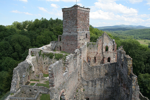
Rötteln Castle
rises above the Haagen district of Lörrach on a 400 meter high,
wooded mountain spur. The elongated castle complex roughly follows
the north-south direction given by the mountain ridge and is divided
into the lower or outer castle and the upper or main castle. The
main castle in particular can be seen from a great distance through
two striking defensive towers. From the fortified towers you can see
the lower meadow valley to the east and south, which at the level of
the castle makes an approximately 90-degree bend. The system extends
around 300 meters in the north-south axis and over 50 meters in the
east-west axis. Along the mountain slope, Rötteln Castle has a
height difference of around 50 meters between the lowest part at the
Spitzeckbastion Kapf in the south and the highest on the Oberburg in
the north.
The foundations of the castle lie partly on the
Jurassic formation of the Upper Dogger, partly on sea sandstone
conglomerates that can be assigned to the Middle Oligocene. The
eastern third of the system stands on the Upper Main Roe Stone, the
middle one on the Movellier, Ferrugineus and Varians layers, the
western third on sea sandstone conglomerates. All types of rock were
used in the construction of the castle. The "pale red, silicified
red sandstone blocks of the towers and the deep red, fine-grained
red sandstone, which was used wherever profiled workpieces were
required (window and door frames, consoles, vaulted ribs, floor
tiles, gemstones, coats of arms, etc.)" come from the Wiesental. The
steep slope from which the mountain spur with the castle protrudes
and the Röttler Forest that begins north of it are geologically part
of the Black Forest.
The terrain slopes down from the
mountain spur more than 15 meters into a spacious ditch. This
favorable topographical situation may also have been the decisive
factor in building a hilltop castle there.
Rötteln Castle can
be reached from Röttelnweiler in the south via a steep (gradient:
13.5%) road that leads over the federal motorway 98. A parking lot
for visitors is located directly under the castle on a small
plateau, which is bounded further west by the Karlshöhe. To the east
and northeast, the spur drops steeply into the Manzental, which is
particularly densely populated in the lower part. From the parking
lot, an asphalt path leads in a serpentine along the western flank
of the outer bailey to the main portal in the south of the castle.
To the north of the castle, several hiking trails cross at a
barbecue area. Among other things, the 13th stage of the Westweg
runs there, which leads from Pforzheim to Basel. Part of the Westweg
route runs past the walls of the upper castle through the gate on
the round tower in the northwest to the south portal and thus
through the castle complex. One waypoint is a stone, three meter
high granite portal, the so-called portal Dreiländereck Lörrach. The
southernmost of a total of twelve Westweg information portals on the
national long-distance hiking trail is located at Rötteln Castle.
With the support of District Administrator Albert Peter, the ruins and the surrounding area were designated as a protected area by ordinance of February 18, 1938. Today the landscape protection area Schloß Rötteln and the surrounding area comprises 50.9 hectares and is described as follows: “Very remarkable large castle ruins in an excellent landscape location and surroundings, especially tree gardens, bushes, meadows, forest edge.” The protection area includes the southern part of the Röttler forest and is bounded in the south by the course of the A 98 and in the east by the settlement area of the district of Haagen.
The
younger part of the castle, the extensive lower castle, also called
the outer castle, forms a spur process at the southernmost point. It
is around five meters lower than the main castle and is separated
from it by a ditch. From the south end, the facility opens into a
pointed corner bastion, the Kapf. The ski jump originally used as a
place of execution was built in a star shape, but was removed by the
French army at the end of the 17th century. The large plateau can
still be seen.
The lower castle has only been documented
since the late Middle Ages, which is why research so far assumed
that it did not exist before 1316, when the castle passed to the
margraves of Hachberg-Sausenberg. However, archaeological findings
from 2011 suggest that at least parts of it existed as early as the
13th century. Its base is enclosed in the west by a double ring and
three shell towers. The part of the castle measures 120 in the
longitudinal axis and almost 60 meters in width, making it four
times as large as the main castle.
The lower castle is
entered from the south via the lower castle gate as the main
entrance. The year 1468 is carved on the upper edge of the archway.
There used to be a drawbridge over a moat and a tiered gate at this
point. The lower castle can be visited free of charge. From the gate
a straight path leads uphill in the lower castle. To the east of it
was the land registry with the court table of the regional court, of
which only the foundation walls have been preserved. This was
followed by farm buildings further north, some of which were built
over with newer houses. The castle tavern to the west of the path is
still used as a restaurant. Further north, the areas bounded by the
foundation walls of other farm buildings are used as a stage and
auditorium for the Röttler Castle Festival.
In the upper
third of the lower castle, the path divides, at the fork of which
there is an old cistern. The western path leads straight ahead over
the north-west gate and the Vorwerk back out of the castle. A
massive round tower at the gate is called "The Landscape" in
reference to the rural administration and jurisdiction on Rötteln.
Branching off in front of the north-west gate, a steep path leads to
the former Landschreiberei, on the upper floor of which the
Röttelnbund has set up a small museum for Rötteln Castle. There is
also a ticket office for visitors to the upper castle. The
Landschreibererei can be reached both from the fork and via the path
that branches off to the east. One room, known as the Knechtstube,
is used by the Lörrach registry office for weddings on request.
In the western front of the lower castle, three smaller defense
towers are integrated into the masonry. On this side a battlement
leads past the castle in a northerly direction to the central main
gate.
The upper castle, also known as the main
castle, can be reached from the gate building with the guard room
over a steep wooden bridge. Access was once via a drawbridge, the
traces of which can be seen on the portal. It led over a deep ditch.
The stone bridge pillars are still preserved. In the Middle Ages
this was the only access to the upper castle. When the main gate was
locked, only a narrow entrance to the right of the portal allowed
access. The top of the gate has a coat of arms of the margraves of
Hachberg-Sausenberg. It's a copy; the original with clear traces of
weathering is in the small castle museum. Key loopholes on both
sides of the portal served to defend the complex. After the portal,
inside the upper castle, there is the gate system from different
construction periods with a guard tower on the south tower. The
former tower watchman's room was equipped with a fireplace.
A
winding path, partly laid out with original cobblestones, leads up
to the castle courtyard. This approximately 75 × 30 meter area is
the oldest and most heavily modified part of the castle. The most
elementary structures of the upper castle are the two distinctive
towers, which in their longitudinal axis shield the palace building
to the east.
There are no other noteworthy buildings on the
west side of the upper castle. Research therefore assumes that the
plant will be used intensively. In addition to areas with a cellar,
the mouth hole of a cistern can be seen in the lower courtyard area.
From the Rötteler Chronik it is known that it was repaired in 1420,
which indicates that it was already quite old at that time and that
it was built together with the oldest part of the palace. The
storage tank used to supply the upper castle with water was a
so-called filter cistern, which filtered the collected water over
layers of sand and enriched it with minerals. The collected and
purified water could be drawn from a well with buckets.
The
courtyard appears very spacious due to the lack of structures on the
west side. It is also conceivable that there were wooden farm
buildings in the courtyard.
The north
tower forms the northern end of the main castle, stands on a small
rock plateau around 5 meters above the castle area and is the
highest point of Rötteln Castle. It consists of stacked sandstone
blocks without mortar, as was customary for the castles of the Upper
Rhine. At a height of about eight meters, the tower tapers slightly
with a coffin cornice. However, this does not indicate different
construction phases, since there are also stone of this type in the
lower area.
Alternatively, the north tower is also known as
the Green Tower, which indicates its later use as a dungeon - the
Middle High German word grinen, grin means crying, whining. For
defense purposes, the originally four floors were only connected
with ladders that could be pulled up.
The north tower was
changed several times. The floor plan is rotated 45 degrees from the
longitudinal axis of the castle and is almost square with a side
length of 8 meters. The tower has walls around 2 to 2.3 meters
thick. In the professional world, the quality of stone processing
for a building made of rubble stone is considered unique. The
keep consists of humpback blocks of various types of processing,
which are rather untypical for castles and are used for church
buildings. Above, pincer holes in the blocks indicate the use of
medieval cranes to lift the stones.
The masonry allows
conclusions to be drawn about the construction phases and the period
of origin. Since humpback ashlars were not used before the middle of
the 12th century, it is believed that they originated in the second
half of the 12th century or in the early 13th century.
Archaeological evidence for a more precise dating is missing so far.
What is certain, however, is that the entrance to the keep on the
north-west side was only broken later. The tower is closed by a
platform that protrudes slightly over a cornice and can be reached
via a staircase on the inner walls. Scientists suspect that the
north tower was originally higher. There is a flagpole on the
platform.
On the south-east side there is an originally round
arched high entrance, which is framed with humpback cuboids that are
partly interlocked with the surrounding masonry by long trusses. The
cultivation in the southwest probably dates from the 16th century.
Together with the northwest wall and a shield wall, the extension
forms a space vaulted with an irregular barrel. The donjon is
accessible via a platform above. Only the eastern part of the shield
wall in front of the keep, which runs from east to west, has been
preserved.
On the south side of the upper
castle there is another tower, also called Giller (from Middle High
German gilniz = prison). It served as a maleficent prison, that is,
a criminal and remand prison. Originally it had three floors. Inside
the tower, various items were found during clearing-up work, such as
footcuffs, handcuffs and neck violins.
The crenellated Giller
stands on the eastern edge of the upper castle with a square floor
plan seven meters on a side. The tower made of rough limestone
blocks was probably built around 1300. Originally, a high entrance
in the east at a height of six meters provided access. The south
tower has been accessible to visitors via stairs on the inner walls
since 2001 and has a viewing platform. In the upper third, a
subsequent concrete reconstruction of the original shape of the
tower is striking. Both towers have flagpoles on which the Baden
flag flies.
The hall of the Röttler Burg takes up almost the
entire east side of the upper castle and extends from the north to
the south tower. It consists of three adjoining, multi-storey wings
that can be clearly distinguished from one another by means of
construction joints. Its full height is preserved in places in its
enclosing walls, whereby the subdivision of the floors is not
clearly recognizable; possibly there were also mezzanines. In
several construction phases, the hall was exposed to sometimes very
strong changes. Only the last upper floor extends uniformly across
all wings, so that it can be assumed that the old Romanesque hall
was later expanded and raised. The oldest construction phase is in
the south, the youngest in the north. Accordingly, construction
seams can be seen from the courtyard side, especially between the
corner blocks of the Palas’ and the neighboring building in the
south. One of the hallmarks of the oldest part is the red sandstone
corner cuboid from ground level to the end of the first floor.
The tripartite division of the palace can also be seen from the
stylistically different portals. In the slender, only
five-meter-long middle section there is a 1.90 × 0.80 meter portal
with a raised arch. Its design is similar to that of the Romanesque
north tower and is by far the oldest portal. The northern portal,
measuring 1.90 × 1.15 meters, has flat bevels. The keystone showed
the coat of arms of Margrave Philip and his wife Maria of Savoy. The
number 94 is still visible on the right, so that the portal can be
dated to 1494. It was created at the same time as the southern
portal. The southern portal, designed as a keel arch, measures 2.20
× 1.50 meters and dates from the 16th century. Presumably the arch
was adorned with a coat of arms from Baden and thus marked the
section towards Hachberg. Since there are contradicting information
about the age of this portal, no conclusions can be drawn about the
age of the south wing. Despite the younger age of the south portal,
the south part of the palace is the oldest. In addition to the
construction seams, five seating niches facing the valley on the
upper floor provide evidence of this. The former Romanesque biforias
from around 1200 were replaced by cross-frame windows in the early
modern period. It is noteworthy that only the southern biforium was
preserved as a model for a reconstruction. It has semicircular round
pillars with a simple bulge, notched ornamentation and volute-like
approaches at the top. The edges of the biforias are separated by
pillars that carry cube-like capitals with an oval leaf motif in the
edges. This arcature elevates the steeply sloping terrain to the
east and gives the building an even more representative character.
This representative part of the castle also served the
margravial chancellery to write the chronicle. In view of the fact
that the Röttler family was enlarged by 1200, the palace was
probably expanded in the early 14th century at the latest. The
amenities of the palace building also included toilet bays on each
floor. They were located as cantilevered porches on the moat side in
the east. A reconstruction can be seen on the outside wall of the
palace.
Another large-scale modernization measure in the 16th
century underscores the importance of this component. A second floor
with cross-frame windows was added to the hall over the entire
length. The following rooms open up in the Palas from south to
north: the so-called old building housed a wine cellar and the
knight's hall. This was followed by a much smaller room that was
used as a bread cellar. This room, together with the chamber that
allows access from the arbor, belongs to the central part. The new
building includes smaller chambers, a large room with a fireplace
and a hall. The function of the hall remains open. There is no
evidence to suggest that it is a chapel. However, there was a St.
Mary's Chapel at the castle, as evidenced by a document from 1504. A
castle chaplain is documented for the year 1389. The chapel, the
foundations of which have been preserved, stood to the west of the
north wing of the palace. The beginnings of its Gothic vault can
still be seen on the walls. The massive altar table has been
preserved, but was moved to the Palas after the castle was
destroyed. Research assumes that the chapel was then used for other
purposes, as seating niches were built into its wall and a fireplace
was built into one of the fronts.
A LiDAR image shows a polygonal ski jumping facility with two north and west facing bastions (bastionary earth fortifications) which are connected by a wall about 150 meters northwest of the keep. A wide moat was dug in front of the ramparts and bastions in the southwest and northwest. An additional wall is visible to the southeast, which leads from the northwestern bastion to the cut of a small valley between the castle and the hill. A square structure (approx. 30 × 30 meters) can be seen in the interior, "which could be the foundation of a tower or the location of a former log house ...". The entire complex has a side length of around 200 meters and covers an area of around 5 hectares (the interior of the complex around 1.26 hectares) while the entire castle complex comprises around 1.5 hectares. If you follow the Schlossweg to Hohen Straße from the upper castle, you will find the forest area with the ski jump on the left. In the winter half-year, parts of the ditch and the ski jump can be seen a few meters from Hohen Straße (towards Lucke). In the forest itself you can only see the structure of the entire complex if you have seen the relief map. The area of the ski jump is an excavation protection area according to § 22 of the Baden-Württemberg Monument Protection Act, which provides for fines of up to 500,000 euros for illegal excavations.
The time of origin and expiration
cannot be clearly stated. In the literature it is assumed that Duke
Bernhard von Weimar had the ski jump built in 1638. In a report on
the condition of the castle from the year 1654 it says: "... next to
the Fall Brücke how one leads to the castle above towards the
Schanz." From this it can be concluded that the Schanze already
existed in 1654. In the diaries of Thomas Mallinger, under January
20 / January 30, 1638 aggreg. reports: "If Duke Wimar ... is
entrenched in the upper rulership of Lörch with 800 riders."
However, since the Duke had only captured Laufenburg on this day and
had to include Rheinfelden, this dating is unlikely. At the
beginning of May Bernhard von Weimar moved from Donaueschingen via
Schönau and Schopfheim to Brombach. While an imperial army under
Johann von Götzen camped in the Kinzig Valley at the beginning of
May 1638 to relieve the fortress of Breisach after a further influx,
the Duke camped on May 5th / May 15, 1638 . near Brombach, where his
troops were supposed to recover and wait for the French to move in.
The camp was only established on May 26th / June 5th, 1638.
Relocated to Heitersheim, with which the troops stayed in the
Brombach area for about three weeks. During this phase of the war,
the Duke also had a pioneer troop of 400 men with bridge and hill
masters at his disposal, who at most managed the construction of the
hill.
North of the Alps, between 1550 and 1700,
fortifications with bastion-like corners were built, avoiding blind
spots compared to older linear ramparts and ditches. The
Schwedenschanze (refuge) near Bad Peterstal-Griesbach, the
Altenberg-Schanze near Bad Wimpfen, the Krähenschanze near Hilzingen
and the Schwabenstutz-Schanze near Waldau (Titisee-Neustadt) have a
similar design.
A comparison of the Röttler Schanze with
these jumps from the Thirty Years' War has shown agreement, so that
there is much to be said for dating from March to December 1638.
It can be assumed that because of its
former representative character, the castle was also lavishly and
luxuriously furnished inside. The report of a pilgrim, Hans von
Waltheim from Halle an der Saale, who visited the castle on July 9,
1474 on his return journey from southern France, gives testimony to
this. Waltheim was particularly amazed at the tapestries in
the bower. He wrote:
“[…] That was the prettiest work of
pictures, of faces, of clothing, of animals and flowers and of other
works, just as if it were alive, like I have not seen many. [...] "
The luxury furnishings such as carpets and fireplaces are due to
the lavishly dimensioned state rooms, especially in the hall. The
hall-like room was difficult to heat, so carpets hung on the cold
walls to generate a certain amount of warmth. Smaller rooms were
paneled with wood.
Another proof of the upscale and for the time
comfortable furnishings are stove tiles, which are exhibited in the
castle museum of the Landschreiberei and in the Dreiländermuseum in
Lörrach. Since the 14th century, the technology of chimney
construction had advanced so far that large tiles showed a certain
heat storage capacity. This made more uniform and larger-area
heating possible. In addition to the clay ovens, there were also
cast-iron stoves that absorbed and released the heat more quickly.
Finds in Rötteln Castle confirm that the system was equipped with at
least 10 to 15 tiled stoves. Many came from the time of Rudolf IV.
And Philip, who imported them from Burgundy and western Switzerland.
The stove tiles sometimes have very artistic ornaments and reliefs
with biblical scenes.
Rötteln Castle also had its own
workshops for the manufacture of furnishings. It is certain that a
well-known Burgundian carpenter made carpets and tapestries on
Rötteln.
During maintenance and restoration work, there were
always finds of life in the castle. These include cannonballs,
arrowheads and other fully or partially preserved weapons, but also
items of everyday life such as horse harness, buttons, tools, table
bells and door locks. Finds about the history of the castle are
exhibited together with historical images and a large model of the
castle in the museum in the Landschreiberei.
The majority of
the finds, including the most valuable ones, are exhibited in the
Lörracher Dreiländermuseum, as there was no museum space at the
castle before the rebuilding of the Landschreiberei in 1985. In
addition to stove tiles, this also includes glasses, crockery
fragments, tools, weapon parts, clay pipes, a chess piece, a judge's
table with an executioner's sword and instruments of torture.
The castle ruins are open all year round; Guided
tours are possible by prior arrangement. While the lower castle is
accessible at any time free of charge, the upper castle has
different opening times depending on the season. In addition to a
small museum in the rebuilt rural writing room, there is a castle
tavern in the fortress. The Hugo Häring Prize of the Association of
German Architects was awarded in 2005 for the renovation and
renovation of the Burgschenke Rötteln.
Rötteln Castle is
state-owned and is looked after by the State Palaces and Gardens of
Baden-Württemberg. The maintenance of the castle ruins and the
upkeep of the museum are the responsibility of the Röttelnbund e. V.
Almost 50,000 visitors come to the Oberburg every year for tours and
guided tours.
Every summer since 1968 the association
Burgfestspiele Rötteln has performed plays by mostly classical
authors on a three-tier natural stage in the outer bailey. Since
2000 the festival Jazz auf der Burg has been taking place in the
outer bailey, which is supported by Jazz-Club 56 Lörrach e.V. In the
summer of 2003, an open-air cinema was held at the castle. Usually
twice a year, at the invitation of the Röttelnbund, a “castle
revitalization” is carried out by the medieval exhibition troop
“Bunter Haufen Basel”.
The castle tavern and the beer garden
belong to the city of Lörrach and have been leased to private
operators who will be running a café from December 2017. The
registry office of Lörrach maintains a wedding room in a room of the
country writing, the "Knechtstube", which offers space for 25
people. 66 marriages took place there in 2019.
From September
14 to 16, 2018, the temporary art installation RedBalloon: The Tower
was implemented, in which the action artist Klaus Kipfmüller covered
the north tower of Rötteln Castle with 5200 specially made balloons,
played with sounds and illuminated it in the dark. The campaign,
sponsored by local companies, gained regional recognition and
brought around 4,700 visitors to the ruins.
Reception in visual arts and literature
The supposedly oldest
representation of the castle was seen for a long time in a woodcut
that was used in 1545 to illustrate the text about Rötteln Castle in
Sebastian Munster's Cosmographia. However, this is undoubtedly not a
representation of the castle, but merely a symbolic illustration
that was also used in other texts (e.g. on Habsburg Castle).
The oldest known depiction of the castle is a
copper engraving that was printed in 1625 as an illustration for
Daniel Meisner's emblem book Thesaurus philopoliticus. Daniel
Meisner provided the texts and explanations. The explanations were
simply left out in later editions, as the public's interest was less
in the emblems and more in the brochures. The explanation of the
sheet with the illustration Rötteln reads: "This Emblema admonishes
the dear authorities that they tighten the wicked and protect the
religious that the tight should not be greater than the crime."
The illustrations in the book are from different draftsmen and
the printing plates were created by different engravers. The sheet
of Rötteln is - like most of the book in the fifth volume - not
signed. Nevertheless, there is a plausible hypothesis in the
specialist literature that the drawing was made by Matthäus Merian.
The copper engraving shows the castle in its north-south extension
from the north-west.
The second oldest representation of the
castle is the best known and was published in Matthäus Merian's
Topographia Alsatiae from 1643. This illustration also shows the
castle in its north-south extent, but from the east.
There
are not only 18 years between the two representations, but also the
period of the Thirty Years' War in which the castle was directly
affected by the fighting and was also damaged, as is documented by a
description from 1654. It corresponds to the way Merian works that
this damage is not visible.