Location: Kalamos, Attica Map
Tel. 22960 22426
Open: daily
Closed: public holidays
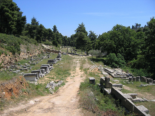
 Oropos Archaeological Site is ancient archaeological site situated near Kalamos in
the Eastern Attica region of Greece. Colonists from Eretria
first settled banks of small river Cheimarros. Local farms was the key in growth of the
city and its wealth. All products were shipped from a Oropos
harbour of Delphinium situated at the mouth of Asopus river a
mile (1.6 km) North of the city. In the 6th century BC the city
was seceded to the Athens after defeat of mother town of
Eretria. In the ancient times
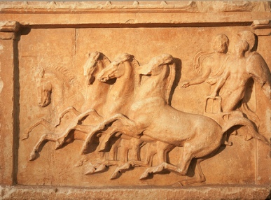
Oropos Archaeological Site became famous for its
oracle of Amphiaraus. Traditionally all visitors threw coins in
the sacred spring. Ancient Greeks believed that this spring had
miraculous powers. According to local legends Greek hero Amphiaraos (pictured on a frieze on the left) was saved by most
important god Zeus during a battle. Greek warrior disappeared
with his chariot in the midst of a battle only to reappear on a
site of a spring. Ancients believed that donating small amounts
would grant them wealth and good luck.
Oropos Archaeological Site is ancient archaeological site situated near Kalamos in
the Eastern Attica region of Greece. Colonists from Eretria
first settled banks of small river Cheimarros. Local farms was the key in growth of the
city and its wealth. All products were shipped from a Oropos
harbour of Delphinium situated at the mouth of Asopus river a
mile (1.6 km) North of the city. In the 6th century BC the city
was seceded to the Athens after defeat of mother town of
Eretria. In the ancient times
Oropos Archaeological Site became famous for its
oracle of Amphiaraus. Traditionally all visitors threw coins in
the sacred spring. Ancient Greeks believed that this spring had
miraculous powers. According to local legends Greek hero Amphiaraos (pictured on a frieze on the left) was saved by most
important god Zeus during a battle. Greek warrior disappeared
with his chariot in the midst of a battle only to reappear on a
site of a spring. Ancients believed that donating small amounts
would grant them wealth and good luck.
Ancient Oropos was a complex with the main temple, a sacred spring, numerous altars and porticoes. Additionally a small theatre put up religious performances. Worshippers who came here slept on skins of slaughtered rams before they went to consult with the oracle himself. With the arrival of Christianity the pagan cult was eventually abandoned. The settlement of Oropos Archaeological Site went into a decline as well.
History
Ancient times
Oropos in antiquity was the strong
rural center of Graia in the city of Tanagra in Boeotia and
originally belonged to the Pandionida tribe. The area is located in
the current location of Skala, on the border between the
administrative power of Thebes and Athenians. In 373 BC. the city
destroyed by the Boeotians falls to the Athenians, while later it
becomes an independent district of Attica. Geographically, it covers
the area from today's Tanagra, Boeotia, to Kalamos, Attica.
Modern Times
In Byzantine times it was an active rural center,
while during the Greek-Turkish war the area was looted and the
Turkish supply base was installed on it.
After the first
administrative division of the Greek state in 1833, the Municipality
of Oropos was formed, which initially joined the province of Thebes.
In 1840 the municipality of Oropos was abolished and merged with the
Municipality of Perea in the province of Attica. The seat of this
municipality, which covered the entire northern area of Attica up
to Parnitha and Marathon, was Oropos. In 1871 the municipality of
Perea was renamed the Municipality of Oropia and its new seat became
Skala Oropou. Within its administrative boundaries, the municipality
included the settlements from Skala and Malakasa, to Kalamos and
Agios Apostolos. In 1912 the Municipality of Oropia was divided into
communities. Oropos was during this period the seat of the community
of Oropos which was maintained until 2002. This year the Community
of Oropos united with the communities of Skala Oropos and Nea
Palatia forming the Municipality of Oropos based in Skala Oropos.
Settlements and neighboring communities
Today satellite
villages of the traditional rural center are Skala, Markopoulo, Nea
Palatia, Sykamino, Halkoutsi, Agios Konstantinos, the resort area of
Agioi Apostoloi, the village of Milesi and Avlonas, a town in
Attica. The holiday settlements of Dilesi and Plaka belong to the
Municipality of Tanagra in the prefecture of Viotia.