Location: 46 km North-west of Budapest Map
Travel Information:
Szent Istvan ter 1
Tel. 33- 415 986
Tue- Sun
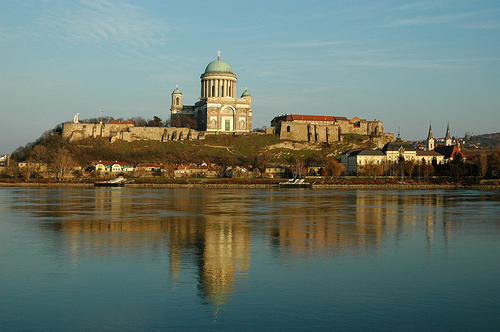
Esztergom (German: Gran, Slovak: Ostrihom, Turkish: Estergon) is
a developed industry, school and port city in Komárom-Esztergom
county, on the right bank of the Danube. Due to its location, it is
also called the highest city on the Danube Bend. The city in today's
sense was established in 1895 by merging the free royal city of
Esztergom and the neighboring Archbishop's Water City, Szenttamás
and Szentgyörgymező. From the change of regime until 2012, the
Constitutional Court, from 1997 the Danube-Ipoly National Park, from
2018 the seat of the Supreme Administrative Court. As the capital of
the Archbishop of Esztergom, the city is the Hungarian center of the
Roman Catholic Church.
Esztergom is a popular tourist
destination, in 2014 it was chosen as a destination by one and a
half million tourists. Its cathedral is one of the largest basilicas
in Europe, and contains the only intact Renaissance building in
Hungary, the Bakócz Chapel. Here you will find the richest
ecclesiastical treasury in the country, with outstanding collections
worldwide. The Christian Museum is the richest ecclesiastical museum
in the country and the third richest diocesan museum in the world.
The Hungarian Red Cross was founded in the city in 1881. Esztergom
is also one of the cradles of Hungarian aviation, Ernő Rubik, a
senior aviation engineer, has been working in the aircraft factory
operating in the city since 1936.
The origin of his name
There are several ideas
about the origin of the name Esztergom. Some say it originates from
Istrom (Istrian means Danube and Gam means nearby Garam River).
Since Esztergom was built in the Danube Bend, the suffix of the gom
can be the bend, curvature (for example: button, sphere, tuber).
According to another idea, the oldest form of the name is
Iszterograd, which may refer to the Garam River, which flows into
the Danube at Esztergom (üsztü means a tributary). In yet another,
the Bulgarian-Turkish estrogen may be derived from the nouns küpe
(i.e., leather armor) and strgun (i.e., tanner) and may refer to the
residence of former leather armor makers. Also related to the origin
of its name, the word Slavic stregomj (who is being looked after)
may come into play. In any case, the first written mention of the
word Esztergom dates from 1079.
Numerous variations of its
name refer to the significance of the city throughout history.
German: Gran, derived from the nearby Garam river name, Turkish:
Estergon, Spanish: Estrigonia, Italian: Strigonia, Slavic languages
only Strihom, (Slovak: Ostrihom, Polish: Ostrzyhom, Czech:
Ostřihom, Croatian: Ostrogon, Serbian: Serbian Romanian: Strigoniu,
Greek: Έστεργκομ. In Roman Latin: Solva, in medieval Latin:
Strigonium. In the local vernacular, only Egom. It is also called
the city of St. Stephen, the Hungarian Zion or the Hungarian Rome.
Geography
Esztergom is located in Transdanubia at the foot of
the Pilis Mountains, west of the Visegrád Mountains, in the
northeastern part of Komárom-Esztergom County, on the right bank of
the Danube, opposite the Slovak Sturovo, with which it is almost
intertwined. It is the northernmost settlement of the county and the
Central Transdanubia region. It is also called the top city of the
Danube Bend. According to the territorial division in line with the
European Union norm, it belongs to the Central Transdanubia Region,
and from the tourist point of view to the Budapest-Central Danube
region tourist region. The Danube surrounds the city in a semicircle
and breaks into two branches to form the Primate Island with the
Little Danube. The castle hill of Esztergom is surrounded by the
river to the west and the Iron Gate to the east, so it is
characterized by its north-south extension. Esztergom-Kertváros is
located on a plain 5 km south of the Old Town, where almost a fifth
of the city's population lives. Esztergom has been the seat of the
Danube-Ipoly National Park since 2005, although the board still
operates in Budapest.
The highest point of the Esztergom
castle hill is 157 meters, it is a castle hill made of dolomite.
Adjacent to this is St. Thomas Hill, a member of the hills
surrounding the city. The surface of this hilly area rises stepwise
in the eastern part, its parts are the Elő-hegy (176 m), the St.
John's Well (175 m), the Orbán Chapel (179 m), the Kusztus (237 m),
the Sípoló-hegy (318 m), the Little Mansion Hill (317 m), the Eagle
Hill (322 m) and the Iron Gate (406 m) which is also the highest
point in the city. The thermal springs of Esztergom erupt between
Szent Tamás Hill, Várhegy and the Kis-Danube branch. Karst water
mixed with thermal water bursts from all of them, their temperature
is around 29 ° C. These springs feed the city’s beach, and the
city’s thermal and adventure baths were built on it. The former St.
George's Hill opposite the castle hill was carried away during the
construction of the basilica.
In Esztergom, the Danube is 18
km long. Other rivers within the city limits, the Little Danube, the
Csenke stream, the Kincses stream, the Szent János or Szentléleki
stream, the Diósvölgyi stream, the Kenyérmezői stream, the Fári
well, the Gypsy and the Triple Fountain. On the left bank of the
Danube, opposite the city, the Garam flows into the Danube. At the
mouth of the Garam is the Great Island, heading east on Mount Burda
and not far from it is the Ipoly. There are several islands within
the administrative boundaries of the city. These are, according to
the Danube, the Körtvélyesi Island, the Nyáros Island, the Táti
Island (part number 0947), the Csitri Island, the Prímás Island, the
Helemba Island, the Dédai Island and the Dwarf -island. The island
with the topographical number 0956, which was above the island of
Helemba, is now completely washed away by the Danube. During the
exchange of administrative territories with the municipality of Tát
in November 2008, each island was transferred to the municipality to
which most of it belonged. Primas Island originally consisted of two
islands, Primas and Water City. These were very close to each other,
so when a ship carrying cement sank on the river back at the turn of
the century, the canal between the two islands was filled with
cement on behalf of the town of Víziváros. This part of the island
is today called Dog Clamp. Among the most important stagnant waters
of the city are the Halas Lake, the Mini Lake, the Bath Lake, the
Round Lake, the Dédai Lake, the Bíróréti Lake, the Palatinus Lake )
and Lake Bottyán (You can read more about the name of Lake Bottyán
in the article History of Esztergom).
History
Middle Ages
The area of the city
was already inhabited in prehistoric times. In Roman times, a
settlement called Salvio Mansio was found on the site of today’s
town, where the Romans built a castrum called Solva, which became
part of the limes. After the arrival of the Hungarians in the 900s,
in 972, Géza chose Esztergom as his new seat, where he also had a
stone castle built on Roman foundations. According to the legend of
St. Stephen, his son, Vajk, was later born here, the later King St.
Stephen, who was baptized here and then crowned king here. The event
of the coronation is immortalized in the sculpture of Stephen,
inaugurated in 2001 by the sculptor Miklós Melocco, on the northern
rondelle of the castle. During the reign of Stephen, the city became
the archbishop's center of the Kingdom of Hungary. The first
cathedral in the country was built on the Castle Hill in Esztergom,
which was named St. Adalbert's Church after István's educator.
Medieval Esztergom was organized into several independent units, the
royal city was surrounded by several suburbs. Until the beginning of
the 13th century, one of Hungary's mints operated here.
In
the 12th century, the city turned II. German Emperor Conrad, VII.
King Louis of France and Frederick Barbarossa were also German-Roman
emperors. By the end of the 1100s, due to the rise of ecclesiastical
influence, the urban development of Esztergom came to a halt, and in
1198 King Imre gave the city to the archbishop. After the 1200s IV.
As a result of Béla's measures affecting Esztergom, urban
development resumed, thanks to which one of the largest Armenian
communities in the country lived here, which also had its own
colony, called Armenia. In the winter of 1242, the Tartars almost
completely destroyed the city, [6] but could not occupy the citadel.
In 1301, Charles Robert was first crowned in Esztergom, invalid, and
then during the interregnum the city changed hands several times.
Esztergom grew into a cultural center in the 15th century,
especially during the archdiocese of János Vitéz, thanks to the rich
court of the high priest. It was often visited by royal guests,
scholars and artists from all over Europe. The only intact
Renaissance building in the country, the Bakócz Chapel, has remained
with us since the beginning of the 16th century. The city was
occupied by the Turks in 1543 and made the border castle of the
Ottoman Empire, the center of the Sandzak in Esztergom. At that
time, several minarets, mosques and Turkish baths were built, which
are now preserved in the water city district. During the Fifteen
Years' War, after the fall of Győr, Károly Mansfeld became the
chief. On September 3, 1595, the troops of Miklós Pálffy recaptured
him with the help of the Hungarian hussars of Count Mátyás
Cseszneky, but in 1605 the castle fell into Turkish hands again. Its
final liberation took place in 1683 with the victory of the King of
Poland, John Sobieski, on the ledge.
17th and 19th centuries
The town was finally recaptured from the Turks by the Polish king
John Sobieski, a memorial in Elizabeth Park, on September 12, 1683,
during the Battle of Párkány. On September 16, 1706, after a
six-week siege of the Kurucs, II. The castle was occupied under the
leadership of Ferenc Rákóczi. After the Kurucs were pushed back and
the town fell into the hands of the Habsburgs, in 1708 Esztergom
regained its free royal city rank. The archdiocese, which had fled
during the Turkish conquest, did not return until 1820, and then,
two years later, in 1822, construction began on the basilica, which
was consecrated in 1856. The event was also attended by Ferenc
József and Liszt Ferenc, the latter composing for this occasion his
work entitled Esztergom Mass, which he conducted during its
presentation.
During the War of Independence in 1848–49,
Lajos Kossuth and István Széchenyi also occupied the city, and on
April 16, 1849, the Hungarian army fought a victorious battle with
the Austrians. In 1876, the city rights of Esztergom with the right
of legislative authority were abolished, and as an organized council
city, it was incorporated into the organization of Esztergom County
with the title of a free royal city. This was justified by the fact
that its population did not reach 15,000 and its economy was not
strong enough. In 1891 the Esztergom – Almásfüzitő railway line was
handed over, and in 1895 the Esztergom-Óbuda railway line. In the
same year, on September 28, the Mária Valéria bridge between
Esztergom and Sturovo on the other side of the Danube was opened,
and this year Esztergom was permanently united with the three
neighboring settlements, the Archbishop's Water City, Szenttamás and
Szentgyörgymező.
From the 20th century
As a result of the Treaty
of Trianon, the city lost much of its catchment area. In 1919, Czech
Legionnaires demolished the Maria Valéria Bridge, which was only
rebuilt by 1927. Komárom and Esztergom, established in 1923,
Esztergom became the seat of the county. In the 1930s, the
underground castle was discovered, and attempts were made to boost
tourism based on artesian baths. The town was a prominent place for
the 1938 St. Stephen's Memorial Year.
In World War II,
retreating German troops blew up the three central openings of the
Maria Valeria Bridge. The Soviets occupied the city on December 26,
1944, and on January 7, 1945, it was recaptured by German and
Hungarian troops. The fighting ended in March 1945. The city
officially remained the county seat until the 1950 county
settlement, but in fact until 1952, as only then was the executive
committee of the county council able to move to Tatabánya. However,
several county institutions, such as the county land office, the
archives, the county prison and the county court, remained in
Esztergom until the late 1980s. It was referred to as a military
city in the 1950s. From its half-century-old wreck, the Mária
Valéria Bridge was rebuilt again in 2001, thus connecting the city
again with its historically formed catchment area. Its regional
leadership is further strengthened by the establishment of the
Ister-Granum Euroregion in 2003, which roughly covers the old
Esztergom County and some areas of Hont County.