Location: South- East Iceland Map
Area: 8,100 km² (3,125 sq mi)
Thickness: 3,300 ft (1 km)
Vatnajökull National Park is located in the South- East part of Iceland. This national reserve is the largest national park in Europe covering an area of 12,000 km2. Vatnajökull National Park also includes the area of the former Skaftafell National Park. It is named after Vatnajökull glacier, largest glacier in Europe. It covers an area of 8,100 km² (3,125 sq mi). Additionally it also contains the highest point on the island nation known as peak Hvannadalshnúkur and most powerful waterfall in Europe, Dettifoss Waterfall.
History
Vatnajökull National Park was established on June
7, 2008. When it was founded, the park covered an area of 12,000
km². Since its expansion to include Lakagígar, Langisjór and
Krepputunga, the park now covers 14,200 km², or 14% of the land area
of Iceland, which makes it Europe's second largest national park.
Only the Jugyd Wa National Park in Russia surpasses it in terms of
area.
On June 25, 2017, the national park was enlarged by
another 189 km². The Jökulsárlón and parts of the Fjallsárlón and
Breiðamerkursandur have been placed under protection by the
Environment Minister Björt Ólafsdóttir.
In 2019 the park was
declared a World Heritage Site by UNESCO.
Geography and
geology
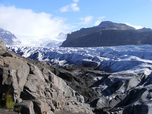
Vatnajökull is Europe's largest glacier with a surface
area of 8,100 km². The average thickness of the ice is between 400
and 800 m, at the thickest point the ice is 950 m thick. The glacier
ice covers a multitude of mountains, valleys and plateaus. It even
covers some active central volcanoes, of which Bárðarbunga is the
largest and Grímsvötn the most active. The ice masses extend from
over 2000 m above sea level to 300 m below sea level. Nowhere else
in Iceland, except on the Mýrdalsjökull glacier, does so much
precipitation fall or so much water flow into the sea as on the
south side of Vatnajökull. In fact, so much water is currently
stored in Vatnajökull that Ölfusá, Iceland's river with the largest
volume of water, would take over 200 years to transport this amount
of water into the sea.
The landscape that surrounds the
glacier is very varied. In the north, the highland plateau is
crossed by glacier rivers, which swell strongly in summer. The
volcanoes Askja, Kverkfjöll and Snæfell dominate this area, as does
the volcanic table mountain Herðubreið. Long ago, huge glacial
floods cut the Jökulsárgljúfur Gorge into the northern part of this
plateau. The mighty Dettifoss waterfall still thunders into the top
of this gorge, while the picturesque landscapes at Hljóðaklettar and
the horseshoe-shaped cliffs of Ásbyrgi can be found further north.
Extensive wetlands and extensive mountain ranges highlight the
areas around the glacier and further east around Snæfell. These
areas are an important habitat for reindeer and short-billed geese.
The south side of Vatnajökull is characterized by many high,
majestic mountain ridges, between which glacier tongues flow down
into the valleys. The southernmost part of the glacier covers the
central volcano Öræfajökull and Iceland's highest mountain peak,
Hvannadalshnjúkur. Protected by the high ice masses, the overgrown
oasis of Skaftafell overlooks the black sands deposited to the west
of the Skeiðará river. These sands consist mainly of ash, which
comes from the frequent eruptions of the Grímsvötn and is
transported towards the coast by so-called jökulhlaups, glacier
runs.
In the south of Vatnajökull National Park is
Morsárfoss, the highest waterfall in Iceland.
The west of
Vatnajökull is also largely dominated by volcanic activity. Two of
the world's largest fissures and lava eruptions in historical terms
took place there: at Eldgjá (934) and Lakagígar (1783–1784).
Vonarskarð, northwest of the glacier, is a colorful, well-tempered
area and represents a watershed between north and south Iceland.
Climate
The weather can vary considerably in an area as large
as that of the national park, especially since there is a large
difference in altitude.
Precipitation in the lower areas
south of the Vatnajokull Ice Cap varies between 1,000 mm and 3,000
mm per year. Temperatures fluctuate between 10 ° C and 20 ° C in
summer, while winters are rather mild (the thermometer rarely falls
below −10 ° C and the temperature is often well above freezing
point).
On the mountains and on the ice cap itself, annual
precipitation can reach 4,000 to 5,000 mm, with most of it falling
as snow. The thickness of the snow cover on Öræfajökull can be
between 10 and 15 meters after a rainy winter. Some of the snow
melts while the rest of the snow forms the glacier ice. This process
takes place everywhere above the snow line on the Vatnajökull ice
cap.
Temperatures on the southern part of the ice cap
are almost always below freezing and can drop as low as −20 ° C or
−30 ° C in winter. Since strong winds and storms are normal, the
wind factor must be taken into account. Wind can have an essential
effect on outdoor activities, even if the prevailing air temperature
is otherwise relatively high. The further north you get behind the
ice cap, the lower the annual rainfall. To the northeast of the ice
cap, it falls to 350-450 mm per year, which is the lowest rainfall
in Iceland. The precipitation rises again closer to the north coast
and in parts of the highlands around Askja. The temperature can drop
relatively sharply on clear and windless days in winter.
South winds generally lead to little or no precipitation in the
north, which is associated with higher temperatures. North winds
bring clouds with them, resulting in colder and wetter weather in
the north of the country, while the south remains sunnier and
milder. The same goes for westerly or southwest winds, which bring
warmer weather to the east. The opposite is the case when the wind
comes from the east: it leads to cold and precipitation in the east
and to better weather in the west of Iceland. This is the result of
the foehn wind: moist, cold air rises near the highlands, condenses
and falls as rain over the highlands, while warmer, drier air falls
down into the valley on the other side. The temperature difference
can be 10 ° C or more.
Services
Vatnajökull National Park
is divided into four areas, each of which is managed individually.
The northern area consists of the northwestern part of the
Vatnajökull, the Askja Caldera and its surroundings, the
Jökulsárgljúfur Gorge and parts of the Jökulsá á Fjöllum river
valley. A visitor center and a camp site can be found in Ásbyrgi,
another camp site is at Vesturdalur.
In addition to the
Kverkfjöll Mountains and the northeastern part of Vatnajökull, the
eastern area also includes the foothills of Snæfellsöræfi. A visitor
center is located in Skriðuklaustur.
The southern area
extends through the southeastern part of Vatnajökull, or from the
Lómagnúpur mountains in the west to Lón and Lónsöræfi in the east. A
visitor center and a campsite are in Skaftafell. Information centers
in Höfn, Hoffell, Hólmur and Skálafell also cooperate with the
national park administration.
The western area extends
through the southwestern part of Vatnajökull and large areas outside
the glacier, including the Lakagígar craters and Langisjór. An
information center is located in Kirkjubæjarklaustur and is run
jointly by the national park and the local community.
The
visitor center in Skaftafell is open all year round. The centers in
Ásbyrgi and Skriðuklaustur are open from the beginning of May to
September, but can also be opened in winter upon request. However,
it should be noted that most parts of the national park in the
highlands cannot be reached in winter.
National park
employees carry out controls and offer courses in the highlands. The
opening times of the centers vary from area to area, with the first
employees driving into the highlands as soon as the main roads are
clear. This is around the middle of June and they leave the area in
late September.
During the summer, staff offer short hikes
with an emphasis on natural history. From mid-June to mid-August,
they conduct daily interactive walks in Àsbyrgi and Skaftafell. In
the highlands, on the other hand, most locations offer daily hikes
from early July to mid-August.