Location: Co Carlow, Dublin, Wicklow, Wexford Map
Area: 3000 km2 (1158 mi2)
Official site
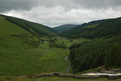
Wicklow Mountains or Sléibhte Chill Mhantáin cover 3000 km2 (1158 mi2) in the Counties of Wicklow, Dublin, Carlow, Wexford. It is the largest continuous upland area in Ireland inhabited since Neolithic times. Highest peak of Wicklow Mountain is Lugnaquilla at 925 meters (3,035 feet). Wicklow Mountains is part of the important metalliferous belt if Ireland with mining dating back to 3000 BC then people first settled the region. Remains of human activity are spread around the region of Wicklow Mountains. One of the most important mining sites are in Avoca and Glendalough.
The Wicklow Mountains mainly consist of granite
and slate that were folded during the Caledonian mountain formation
phase. The mountains, which are rounded by glacial glaciers, are
covered over a large area by peat bogs.
Under these conditions, a diverse flora has developed. In the
valleys and lower slopes, this mainly consists of royal fern, gorse,
and heather, grasses such. B. sedges and wild blueberries. In
particular, the heather herbs contribute during the flowering time
in the summer to a typical for the Wicklow Mountains picture in
which they cover the whole mountain slopes violet.
Forests are more of an exception in the Wicklow Mountains, as they
were cut down early by humans. The widespread deforestation of the
forests was also the reason for the widespread spread of the moors.
In the present time, however, is increasingly being reforested
arealwide. However, these are no longer the original oak and birch
forests, but fast-growing spruce species whose wood can be used
within a few years for the wood industry. In some places, however, a
reforestation in the sense of a restoration of the original
deciduous forests takes place for some years, such. B. in the
northern slopes of the Derrybawn Mountains above the Lower Lakes of
Glendalough.
Mountains
The Wicklow Mountains, like all Irish mountains, are not
particularly high. The highest mountain is the Lugnaquilla (Log na
Coille) at 925 m, followed by Mullaghcleevaun (Mullach Cliabháin) at
849 m and Tonelagee (Tóin le Gaoith) at 817 m.
Other mountains (according to altitude):
Corrigasleggaun (Carraig na Sliogán) 794 m
Slievemaan (Sliabh Meáin) 759 m
Camenabologue (Céim na mBulóg) 758 m
Kippure (Cipiúr) 757 m
Conavalla (Ceann an Bhealaigh) 734 m
Djouce (Dioghais) 725 m
Seefingan (Suí Fionnagáin) 723 m
Due to the moors-dominated landscape, most of the mountains in the
Wicklow Mountains have a rounded plateau-like peak. Due to strong
soil erosion, these are often covered with partly full-sized soil
furrows (so-called peat hags). In particular, by the popular
mountain hiking so stronger erosion paths have already emerged,
such. B. on the mountain Djouce. Several organizations, most notably
the Wicklow Mountains National Park, design frequently used trails
(such as parts of the Spink Glendalough) with floorboards
(boardwalks) to prevent amplification of human erosion.
Rivers, lakes and use of water
The River Slaney has its source in the southwest of the mountain
Lugnaquilla and flows 117 km along the western foothills of the
mountains to the south, before it flows at Wexford on the St. George
Canal into the Irish Sea. The River Liffey, widely known as a major
part of the cityscape of Dublin, has its source east of Kippure and
southeast of the Sally Gap (Bearna Bhealach Sailearnáin). Numerous
lakes, so-called Loughs, additionally characterize the landscape.
Significant are Lough Tay (also called Luggala Lake, Irish Loch Té),
Lough Dan (Loch Deán), Lough Bray (Loch Bré), Lough Ouler (Loch
Iolar), Lough Nahanagan (Loch na hOnchon) and Upper Lake (At Loch
Uachtair) and the Lower Lake (Loch na Piste) in Glendalough.
There are several waterfalls in the Wicklow Mountains. The largest
and most famous waterfall is the Powerscourt waterfall (Eas Chúirt
at Phaoraigh), at the same time the highest waterfall in Ireland.
Another larger waterfall is located in Glenmacnass immediately on
the Military Road east of the mountain Scarr (Scor). The Poulanass
Waterfall (Poll an Easa) in Glendalough is another well-known
waterfall in the Wicklow Mountains.
The Turlough Hill power plant is the only pumped storage power plant
project in Ireland. It is located on the top of Turlough Hill (Cnoc
an Turlaigh), just off the Old Military Road and just off the
Wicklow Gap (Bearna Chill Mhantáin).
In Roundwood on the eastern foothills of the mountain range is the
Vartry Reservoir Lakes, fed by the Vartry River (Abhainn Fheartraí),
which represent the drinking water supply for Dublin. On the other
side at the western foot is the Blessington Lakes, which also serve
as a reservoir for the Dublin drinking water supply.