Location: Veneto
Cortina d'Ampezzo is an Italian ski resort situated in the picturesque Dolomitic Alps in the Veneto region of Northern Italy.
Some experts have
hypothesized that the word "Cortina" may derive from the diminutive
of curtis (from the late Latin, "corte"), which in the early Middle
Ages indicated small territorial units forming part of a fiefdom,
and including houses and lands, some of which freely usable by the
villagers, other private properties of the lord. However, "Cortina"
could also indicate a "small courtyard", that is a space bordered by
a low wall, used in the past for religious functions and as a
cemetery. Perhaps already in Roman times there could have been an
inhabited center in Ampezzo - but there is no certain evidence to
support this thesis - where this "curtain" stood precisely.
According to the scholar Mario Toller, Ampezzo also draws its
origins from Latin: either from the phrase ad piceum, that is "near
the fir", or from the word amplitium (in turn deriving from amplus,
"large"), that is "open place and spacious ". Lorenza Russo, on the
other hand, believes that this etymology is outdated and that it is
rather to be sought further back in time "going back to a prelatin
root amp- / amb- which designates wild plants from which a liquid
suitable for fermentation is extracted, from which both the Italian
name that the Atesine denominations of raspberry: ampomola
(Vallagarina), ampoma (Val di Sole) and ampomes (Val Gardena) ».
From a purely historical point of view, the first evidence of
the name of this mountain locality as well as of the presence in
Ampezzo of a stable community, dates back to an ancient notarial
document dated 15 June 1156, the date according to which two
brothers, Giovanni and Paganello, bought a plot of land from a
Treviso landowner. Artroto, the notary who drew up the deed of sale,
specified that the name of the place where these lands were located
was Ampicium Cadubri, "Ampezzo del Cadore". The oldest evidence of
the juxtaposition of these two deonominations, Curtina ampitii, is
instead found in a document dated 1317, preserved in the archive of
the High Rule of Lareto.
Part of the domains of
the Republic of Venice from 1420, until 1511 it was an integral part
of Cadore of which it constituted one of the ten centuries. When
Cadore was invaded by Massimiliano d'Asburgo at the beginning of the
war of the League of Cambrai, the Venetian army, in reconquering it,
gave up occupying the Ampezzo and headed towards Friuli. During the
Habsburg period the municipality was part of the County of Tyrol.
It was annexed to Italy following the First World War, separated
from the rest of Trentino-Alto Adige and incorporated into the
borders of the Veneto Region.
Cortina is located in the center of the Conca
d'Ampezzo, in the upper Boite Valley, which was the terminal basin
of an ancient Quaternary glacier, and is positioned between Cadore
(to the south) and Val Pusteria (to the north), the Val d'Ansiei (to
the east) and Alto Agordino (to the west). With its 252.81 km²,
Cortina d'Ampezzo is the third largest municipality in Veneto (after
the capital Venice and Porto Tolle in the province of Rovigo).
The geological formations present within the regional natural
park of the Ampezzo Dolomites are of clear sedimentary origin,
dating back to a period between the Middle Triassic (230 million
years ago) and the Upper Cretaceous (90 million years ago) of the
'Mesozoic era, consisting mainly of rocks such as dolomite and
limestone.
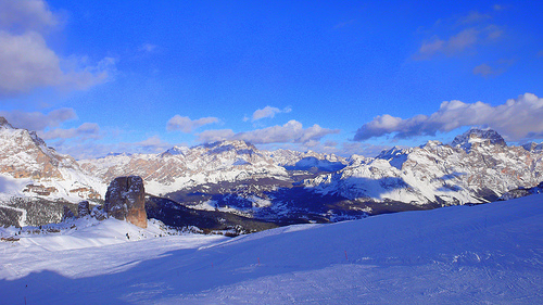
Cortina is 360 ° surrounded by the Ampezzo Dolomites, part of the subsection of the Sesto, Braies and d'Ampezzo Dolomites, in the Eastern Alps, which give the valley a unique beauty in the world. Among the most famous mountains are the Tofane to the west, the Pomagagnon to the north, the Cristallo to the north-east, the Faloria and Sorapiss to the east, the Becco di Mezzodì, the Croda da Lago and the Nuvolau group to the south. The municipal area varies in altitude from a minimum of 1057 m to a maximum of 3244 m, with an altitude range of 2187 m. The urban center, on the other hand, is located at an altitude of approximately 1224 m.
There are numerous
streams and water basins that form the Ampezzo hydrographic
ensemble: the sources of Rufiédo, Felizón and Boite represent real
hydrological peculiarities on the Ampezzo soil, being united by the
derivation from underground karst-type conduits; the Boite and Fanes
streams flow in spacious riverbeds rich in vegetation, forming
splendid waterfalls (Gola di Fanes) on their path; the rio
Travenanzes and the rio Felizón, on the other hand, flow in very
deep natural ravines, carved into the dolomite by the constant flow
of their waters over the centuries. Streams and torrents that flow
along the rocky slopes of the mountains and in the woods, such as
the Ruoiba and the Ru dei Cavai, are also very popular. Almost all
the waters of the valley's catchment area, however, sooner or later
flow into the Boite stream, the largest in the area in terms of
water flow and length of the course (42 km overall).
The
small alpine lakes, on the other hand, are very modest, due to the
accentuated steepness of the slopes and the high permeability of the
dolomitic rocks. There are, however, some small lake reservoirs,
located both at high altitudes and at the bottom of the valley,
whose formation was made possible by a natural process of
waterproofing the bottom of some depressions or by the artificial
damming of streams. In any case, they constitute biotypes of high
naturalistic interest. Small glaciers of modest surfaces hide in the
colder and shady recesses of the Cristallo, the Tofane and other
Ampezzo peaks, at altitudes between 2 800 and 3200 m, sometimes
buried under a thick blanket of debris. Although in constant retreat
due to the progressive increase in summer and autumn temperatures,
they continue to feed the streams and streams of the valley floor,
guaranteeing the Ampezzo a minimum level of water even in cases of
scarcity or absence of rainfall.
The Ampezzo
climate is intermediate between the oceanic climate, which is
typical of the subalpine area less distant from the Adriatic, and
the continental one, typical of the more inland and sheltered alpine
valleys, with cool but short summers and very long and rigid
winters. As already stated, annual rainfall is around an average of
1,100 mm of water per year, with maximum peaks in the summer months
of June and July and minimum in February. Between the end of
December and the beginning of January of each year, some of the
lowest temperatures in Italy are recorded, in particular at the
Cimabanche pass, the border area between the provinces of Belluno
and Bolzano. The mid-seasons, on the other hand, are generally
rather humid and rainy, cold and very windy.
According to the
data collected over the thirty-year period 1961-1990, the average
temperature of the coldest month, January, is -2.5 ° C, while that
of the hottest month, July, is +15.4 ° C. .