Location: border of Italy and France Map
Elevation: 15,770 ft (4,808 m)
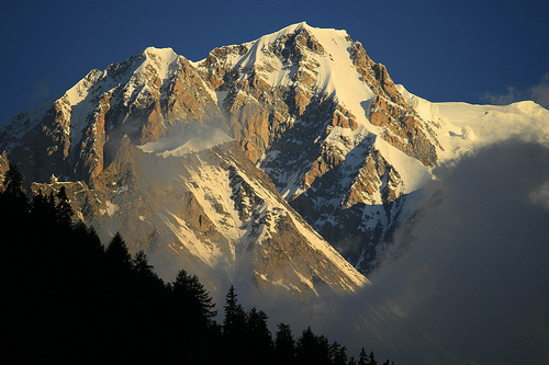
Mont Blanc (Mont Blanc in French and in Arpitano), with an altitude
of 4807 m above sea level (according to the last official
measurement carried out on 3 December 2017), it is the highest
mountain in the Alps, Italy, France and even in Europe, according to
some geographical conventions, hence the nicknames of roof of Europe
and of King of the Alps, sharing a place among the so-called Seven
Peaks of the Planet together with Mount Elbrus in the Caucasus.
Located in the sector of the North-Western Alps, along the
alpine section of the Graian Alps, on the watershed between Valle
d'Aosta (Val Veny and Val Ferret in Italy) and Upper Savoy (Valle
dell'Arve in France), in the municipal territories of Courmayeur and
Chamonix-Mont-Blanc, gives its name to the massif of the same name,
belonging to the subsection of the Mont Blanc Alps. Predominantly of
a granite nature, bristling with pinnacles and ridges, carved by
deep valleys through which numerous glaciers flow, it is considered
a mountain of great attraction for international mountaineering and,
from the point of view of mountaineering historiography, the birth
of the alpinism itself coincides with the date of his first ascent:
8 August 1786.
From the Italian view, the Roof of the Alps is not all that flashy
compared to the other peaks that surround it. Unlike the other great
giant of the Alps, Monte Rosa, visible throughout the north-western Po
Valley up to the first Apennine hills, Mont Blanc appears only at the
last moment along the road to Courmayeur, hidden by a myriad of
satellites minors. Looking at it from the west, however, it is clearly
visible from far away, from the heights of the French Massif Central,
from those of the Vosges, from the heights of the Jura, from
Switzerland, from the Black Forest.
It is perennially covered in
snow and is located in the central part of a chain of mountains which
extends 40 km in length and 8 to 15 km in width, over the territories of
three different states, occupying an area of about 645 km²: the massif
of Monte White. If we exclude the east wall of Monte Rosa di Macugnaga,
the highest in the Alps, this massif contains some of the highest walls
of the alpine system such as the Brenva and the north face of the
Grandes Jorasses and forty peaks are grouped above the 4,000 m, with a
third of the surface at an altitude of no less than 3,000 m. Over time,
the action of erosive agents on the granite rocks has formed sharp
ridges and pinnacle peaks of particular beauty which attract climbers
from all over the world to the region.
While the French side
descends slowly on a slope, the Italian side is formed by a steep and
majestic granite wall which from the highest peaks falls to the bottom
of the Ferret and Veny valleys. On this side there are the most
difficult and demanding walls to climb. The inhabited places are located
below 2,800 m, while the passes are rare and difficult, the lowest of
which is that of the Giant at 3,359 m. Here are some emblematic peaks:
The Dente del Gigante (4,014 m) is one of the most famous peaks. It
rises about 160 m above the characteristic snow gum.
The Grandes
Jorasses: on its summit, about 1 km long, it groups together a sequence
of six peaks, five of which exceed 4,000 m.
The Aiguille Noire de
Peuterey (3,773 m) is one of the symbols of Mont Blanc on the Italian
side: it rises directly from the meadows of Val Veny for a difference in
altitude of 2,200 m; it is the most important peak of the Peuterey
crest.
The Dôme du Goûter (4,306m). If the summit of the Grandes
Jorasses is bristling with peaks, that of the Dôme du Goûter is
completely flat and is the largest of all the Alps.
Mont Dolent
(3,820m) is a pyramidal peak; curiously its summit is the meeting point
of the borders of Italy, Switzerland and France.
the Spires of
Chamonix, between 3,000 and 3,842 m, dominate the Chamonix valley and
represent one of the most famous landscapes in the French Alps.
Below the summit cap, under a blanket of ice and snow 16 to 23 m
thick, at an altitude of 4,792 m is the rocky peak, located about 40 m
further west than the summit itself. In 1740 the Swiss mathematician
Nicolas Fatio de Duillier was the first to determine its height using
the trigonometric system: according to his calculations, the White
measured 4,000 m. Thirty-five years later, in 1775, using the same
method as de Duillier, the English mathematician George
Schuckburgh-Evelyn indicated the altitude at 4,804m. Through the
barometer in 1787 Horace-Bénédict de Saussure measured 4,809.07 m while
in 1844 the French physicist Auguste Bravais measured 4,810 m and in
1892 Joseph and Henry Vallot 4,807 m.
In August 1986 the
orthometric measurement taken by satellite was 4,804 m. Subsequently,
the official height was 4,807 m for a long time, to then pass in 2001 to
4,810 m; in 2003 at 4,808 m; in 2005 it was 4,808 m; in 2007 at 4,810 m;
in 2009 4,810 m and in the last measurement in September 2015 at 4,808
m, lower than the previous measurement of 1.29 m. These variations are
due to the winds which accumulate the snow on the top, consequently
determining its height. If during the year there are fewer windy days
than in the previous year, as a result less snow will accumulate,
affecting its height. Due to the continuous variations of the ice cap,
an official survey has been made every two years since 2001. The
measurements are carried out by the provincial chamber of surveyors of
the Haute Savoie in collaboration with a company specialized in GPS
surveys. After the drought of 2003, the measurement carried out in the
month of September of that year certified the height at 4,808.45 m and
on that occasion it was ascertained that the summit had moved 0.75 cm to
the north-west with respect to the position of the 2001.
During
that measurement campaign, more than 500 fixed reference points were
placed on the summit cap in order to precisely study the variation of
the ice volume above 4,800 m which in 2003 was 14,600 m³, 14,300 m³ in
2005 to arrive to the current 24,100 m³. Mont Blanc is the highest
mountain in the entire Alpine chain and also considered the highest in
Europe. However, if the Caucasus is considered as the south-eastern
geographical limit of the continent, those located in Russian and
Georgian territory are cited as the highest peaks in Europe, such as
Elbrus which culminates at 5,642m, Dykh Tau with 5,203m, the Shkhara at
5,200m and Kazbek at 5,047m.
The mountain complex of the Alps was generated during the Tertiary
Era thanks to the thrust of the African and Asian tectonic plates,
through a process of vertical elevation. About 300 million years ago,
during the Hercynian orogeny, a large granite intrusion formed the basic
structure of the current Mont Blanc massif. Modern surveying methods
highlight today how the elevation of the Alps continues incessantly and
still overcomes the effects of erosion. Metamorphic rocks (gneisses,
mica schists and calc schists) emerged around the granite (protogynous)
nucleus. The most frequent rocks are:
the granites, which are
distinguished in the central part of the Massif by the spire-shaped
crests and the acute shapes of the reliefs. Although very hard, this
rock does not resist the effects of erosion caused by ice.
Metamorphic rocks, which surround granites. These rocks contain the same
families of crystals as granites, but their resistance to erosion is
minimal and their shapes are more slender than the others.
Sedimentary rocks, which are generally grouped into two large families,
namely basic rocks (limestone, dolomite, calc schist, carniole), and
acidic rocks (stoneware, clayey schist, quartzite).
Millions of years later (as already mentioned, it has still been
evolving for 70 million years) the Alpine orogeny raised this granite
intrusion creating fractures in which cracks and fissures opened. The
formation of mineral crystals is the result of mineralized water being
injected into these fissures. The growth process of the quartzes in the
alpine fissures is not yet fully understood. For this reason, Mont Blanc
is also known as a mineralogical locality and a large quantity of
different minerals comes from its slopes, above all rock quartz and pink
fluorite considered the best. As evidence of a past of exploitation of
mineral resources in the massif, on the Italian side there are still two
ancient mines of silver galena and blende, abandoned for some time now.
One was already known in antiquity with the name of Trou des Romains and
it really seems that its exploitation began in Roman times; the other,
the Miage mine was abandoned in the 19th century, and is positioned at
an altitude of 3,500 m, with the entrance directly from the rock face,
at the foot of the Tête Carrée.
At 3,462 m above sea level, in
Punta Helbronner, on the Terrace of the Glaciers there is a permanent
exhibition of crystals from the Massif and among the 150 minerals on
display you can admire the most particular varieties of rock quartz,
hyaline and smoky morions ; the Vesuvius and the garnets found near
Châtillon, the minerals of the ancient mines, among which the samples of
native gold of Brusson and of violano of Saint Marcel, the only locality
of discovery in the world. Jacques Balmat's knowledge of the massif was
also due to the fact that he himself was a crystal seeker (as well as a
chamois hunter), and if quartz and fluorite are the sovereign minerals
of Mont Blanc, many can be found still others such as: Adularia
(KAlSi3O8); Ankerite (Ca(Fe++, Mg, Mn) (CO3)2); beryl (Be3Al2Si6O18);
Calcite (CaCO3); Dolomite (MgCa(CO3)2); Hematite (Fe2O3); fluorapatite
(Ca5(PO4)3F); Galena (PbS); Siderite (FeCO3); Titanite (CaTiSiO5); the
Epidote (Ca2(Fe+++, Al)3(SiO4)3(OH)).
Mont Blanc has a mild climate, it is 240 km from the Mediterranean
Sea and 620 km from the Atlantic Ocean. In the massif where it is found,
the climate is semi-continental and is conditioned by the humid winds
coming from the Atlantic. Once they reach the massif, these tend to cool
along the watershed and on the heads of the valleys, causing rainfall
conditions at low altitudes, with a maximum of rainfall in July and
August and a minimum in January and February. Weather conditions can
change very quickly with heavy snowfalls, sudden fogs and freezing
winds. Above approximately 3,000 m, precipitation in autumn and spring
falls mainly as snow, rarely as freezing rain, and is more frequent in
summer than in winter due to the decreased humidity of the cold air in
winter.
Above 3,800 m, all precipitation is snowy and guarantees
a strong accumulation of snow on the glaciers that surround the
mountain. These precipitations often turn into real snowstorms,
especially on the highest altitudes and on the summit where during these
storms the accumulations of fresh snow reach up to 4 meters thick. The
number of days of snowfall above 3500 m can be estimated at between 150
and 160, with a rainfall intensity on the summit of about 20 cm of snow
(corresponding to about 20 mm of water) per day. During the year,
between 15 June and 15 July, around the summer solstice, a sort of thaw
can be witnessed on the summit, with maximum temperatures reaching 3 °C.
The action of the sun melts the surface snow creating water which
filters into the lower layers and then freezes rapidly.
In
addition to the abundant snowfalls, the winds also play a decisive role
in the formation and conservation of the summit ice cap. If on the one
hand the dry winter winds sweep away the snow, on the other hand the
humid spring winds, characterized by abundant rainfall, bring large
quantities of it. On the top the wind speed can reach 150 km/h and the
temperature - 40 °C. Perturbations caused by the foehn are also
frequent, a warm wind that blows from Val Ferret, and in passing the
buttresses of the Valle d'Aosta side it loses humidity causing heavy
snowfalls at high altitudes, to descend towards the Arve valley even
hotter favoring sunny days . During excursions on the mountain, the wind
reinforces the sensation of cold and the perceived temperature is lower
than the actual one in the surrounding environment (Windchill effect).
The Mont Blanc massif is one of the largest alpine areas covered by
ice and its glaciers, 65 in all, occupy an area of 165 km². The largest
are located on the French side where the slopes are less steep and
exposed to the north. These include the Bossons glacier and the mer de
Glace which almost reach the Chamonix valley. In the Alps, the latter is
the third largest, with about 40 km² of extension, after that of Aletsch
in the Bernese Alps in Switzerland and that of Gorner in Monte Rosa,
also in Switzerland. On the southern side, the Italian one, there are
the glaciers of Freney, Brenva, Miage, Mont Blanc, Triolet, Pré de Bar,
to name a few. Among the alpine glacial landscapes, that of Val Veny is
one of the most singular: two imposing frozen rivers descend from the
top of the Bianco up to an altitude of 1,200 m on the bottom of the
valley, barring its entrance. Continuing in the valley itself, another
glacial tongue, that of the Miage glacier, breaks into the valley
occupying it for its entire width for almost three kilometers in length.
Currently Mont Blanc is subjected to continuous monitoring to better
know and understand what happens to the ice on the summit cap. Due to
climate change and the consequent generalized increase in temperature,
for some decades those of Bianco (and in general along the entire Alpine
arc) have been in sharp decline, especially the smaller ones. According
to data from the most recent research, in recent years there has been a
particular phenomenon which considerably increases the ice sheet above
4,000 m, so much so that the top of the mountain has increased by 2.15 m
and the entire summit cap by 10,000 m³ of ice. According to
meteorologists, this increase is explained by the fact that in recent
years the number of days characterized by westerly winds has increased,
i.e. those that push oceanic perturbations very rich in humidity towards
the Alps. This humidity turns into snow at high altitudes, and rain at
lower altitudes.
In the territory on which Mont Blanc stands, the mountain slopes are
steep and smoothed by glaciers, with predominantly acid soils,
consequently the environment is rather poor in flora. Generally the snow
persists above 2,800 m of altitude. On the western side, the first
slopes are located at 3,500 m while on the opposite side they start from
the Valle d'Aosta valley floors. Given the extreme conditions, the life
of plant and animal species is very limited, but among the crevasses or
sheltered between granite walls, some plant species manage to survive up
to 4,000 m, such as the glacier buttercup. At those altitudes there are
also mosses and lichens. At lower altitudes the soils often originate
from calc schists or calcareous rocks and the living conditions for the
plants are less extreme, while remaining characteristic of a severe
mountain environment.
At these altitudes coniferous forests
prevail, populated above all by spruce and larch, but locally also by
stone pine and mountain pine. On the other hand, in the alpine prairie
it is possible to observe many species of flowers including the showy
yellow inflorescences of Hugueninia tanacetifolia, an endemic plant of
the western sector of the Alps, and the Anemone narcissiflora, and again
the gentian (Gentiana clusii), the well-known edelweiss , the rare
yellow bellflower. In the undergrowth we can find the Venus slipper
orchid (Cypripedium calceolus), the Dactylorhiza sambucina orchid, the
martagon lily (Lilium martagon), the aquilegia, the violet (Viola
calcarata), and the common blue gentians (Gentiana verna and Gentiana
acaulis). The presence of the hybrid between the purple gentian
(Gentiana purpurea) and the dotted gentian (Gentiana punctata) is
interesting. Going higher you will come across shrubs such as
rhododendron (Rhododendron ferrugineum) and blueberry. In the heart of
the massif, at 2,175 m a.s.l. there is the highest botanical garden in
Europe: the Saussurea Alpine Garden, which collects and enhances the
natural species of flora characteristic of Mont Blanc.
It takes
its name from the Saussurea alpina flower, named in honor of the Geneva
scientist Horace-Bénédict De Saussure, promoter of the first ascent of
Mont Blanc in 1786. Mammals cannot survive such difficult conditions,
contrary to certain species of birds. At lower altitudes, however, the
fauna is richer and more varied. The proximity of two National Parks
(Gran Paradiso and Vanoise) has contributed to the maintenance and
diffusion of some species that had been reduced to a few specimens.
Among the mammals it is possible to meet the alpine chamois, which
frequents both the alpine plains and the subalpine woods, where it is
also possible to meet two large herbivores such as red deer and roe
deer. The large stony grounds of the Alpine plain see the presence of
the ibex, the golden eagle and its main source of food: the marmot. An
animal that can be found both in the high-altitude meadows and in the
valley floor is the fox. The wolf has been reported in the valley floor.
[24] In the area of the massif, 184 species of birds have been observed
and about 110 of these are nesters. In addition to the eagle, among the
birds of prey you can spot buzzards, goshawks and kestrels.
Sometimes it is possible to observe the circular flight of the
lammergeier, the bearded vulture which became extinct in the Alps at the
beginning of the 20th century and has recently been reintroduced. There
are also black grouse, hazel grouse (in Savoy and Valais, but no longer
in Valle d'Aosta) and the raven. On the other hand, there are few
species of reptiles and they are found at relatively low altitudes,
among these the collared snake, while where the ground is stony and
sunny, the asp can be encountered.
An ancient document edited in Latin dating back to 1091 speaks of a Rupes that in Chamonix was called Alba and Rupes Alba was a toponym of Mont Blanc, which varied many times over the centuries. In fact, there is news of the denomination of Says or Scez Blans in 1319; in 1532 by Mont Saint Bernard; Glaciales Montes in 1581; Mont Malay, Mont Malet or Montagne Maudite between 1606 and 1743, but also La Glacière, Les Glacières or Les Glassières between 1741 and 1743. Clearly visible from Geneva, it was known in this city both as Montagne Maudite and as Mont Maudit and with this name it was indicated on a geographical map concerning the territories around Lake Geneva, published in Amsterdam in 1606 by the Genevan cartographer Jacques Goulart (1580-1622), while the current name in French appeared for the first time in England in 1744 on a map published in London. At that time, the entire massif was located in the middle of the mainland possessions of the Kingdom of Sardinia and the rulers of the House of Savoy, future kings of Italy, had been its legitimate owners for centuries until the sale of Savoy to France in 1861.
The geographical maps of the I.G.N - (Institut Geographique National
de France) show the summit of Mont Blanc entirely in French territory,
in stark contrast with the geographical maps of the I.G.M - (Military
Geographical Institute of Florence), in which the border two states
passes exactly over the top. A bilateral treaty concluded in 1861, still
legally valid, unequivocally indicates the top as a frontier, i.e.
divided in half between the two states. The report on the deportations
to the border states that the border runs along the crest line of the
massif, as seen from the church square of the village of Courmayeur.
However, the summit of Mont Blanc is not visible from Courmayeur,
because it is too deep; the crest line runs further east and further
down, at the height of Mont Blanc di Courmayeur (hence the name). At the
time, this record was maintained by France as the legal basis for the
border, although nothing is specified in the annexation treaty. This
boundary is still shown on current IGN 1:25,000 maps. The part
corresponding to the Italian side is attributed to the municipality of
Saint-Gervais-les-Bains.
This treaty was suspended throughout the
Second World War. On 10 February 1947, with the Treaty of Paris, the
French authorities decided to put an end to the suspension. The
Delimitation Convention, after several changes, was then re-enacted. On
the old route established in 1861, the transalpine authorities demanded
four rectifications.
The most important of these concerned the
Roia valley, Briga Marittima, Tenda, and three minor ones: one on the
Italian side of the Colle del Monginevro, another on the Colle del
Moncenisio, and then on the Piccolo San Bernardo. On the summit of Mont
Blanc the frontier did not undergo any changes.
In the second
half of the 19th century, on the surveys carried out by a French army
cartographer, Captain J. J. Mieulet, a topographic map was published in
France, which arbitrarily incorporated the peak into French territory,
causing the state border to deviate from the watershed line, and thus
giving rise to the differences with the maps published in Italy in the
same period, differences that the official Italian cartography never
recognized from the outset. According to the authors of a book that
appeared years ago in Italian and French bookstores, the 1865
topographic map is a sensational historical forgery with no legal value,
in contrast with the agreements signed between the two states since 1860
and reaffirmed in 1947.
In 2002, the two cartographic bodies
mentioned, the respective Alpine Clubs, the border regions and the
countries concerned published a shared topographic map. This new map,
part of the Alps without frontiers project, goes one step further than
the old maps, but still lacks clarity on the disputed peaks and the
crosses marking the borders appear deliberately spaced out, even if the
differences with the "I.G.N. top 25" map " of 1998 are evident. In
September 2013 some French guides blocked the passage to the summit with
a gate which was removed a few days later by the Italians.
Since
2017 Google Earth has been using the maps of the I.G.M. and of NATO. The
latter takes the data from the Italian ones of the IGM, based on past
official treaties in force and is essential at an international military
level in the event of a possible dispute. The territory that goes from
the Turin refuge to the highest peak of the Mont Blanc massif is under
the control of the Italian authorities. With the current climatic
upheavals, the Italian Civil Protection has highlighted the need for a
clarification between the two administrations in order to avoid
misunderstandings on the responsibilities regarding the surveillance of
the glacier on the watershed whose waters, in the event of melting,
would totally involve the Italian territory.
At the end of the 19th century, special units trained for mountain
warfare were created in the nations of the Alpine arc. Mountaineering
thus became part of military preparation, together with the use of skis.
On 9 January 1934, the Military School of Mountaineering was established
in Aosta, with branches in La Thuile and Courmayeur. The first commander
of the school was Lieutenant Colonel Luigi Masini. France had already
equipped itself in 1932 with the l'ècole de Haute Montagne (E.H.M) based
in Chamonix. The grandiose scenario of the Bianco group was then the
scene of the spectacular exercises of the military schools of the two
countries, with maneuvers at high altitude by specialized units. The
best names in national mountaineering and skiing flocked from the
Italian Alpine valleys to the Aosta school, which had become the
University of mountaineering. In short, enterprises were organized and
completed which aroused great admiration at the time.
On 22 June
1935, more than 200 pupils from the Scuola alpieri took a solemn oath of
loyalty to the homeland and to the King on the summit of Mont Blanc,
climbing it by various routes, some of which were among the most
demanding. The following year, 600 fully armed men crossed the chain of
the Grandes Murailles, from Valpelline to Valtournanche. In 1937 an
impressive high-altitude exercise engaged the entire Duca degli Abruzzi
battalion (500 men) who occupied all the border posts with France to
climb, by different routes, to the summit of the Roof of the Alps. In
1938 it was the turn of the specialized French troops who met on Mont
Blanc on 14 July.
In just a few years, the Military School of
Mountaineering of Aosta became famous and known on an international
level. Subsequently, relatively precisely to Mont Blanc, the Mont Blanc
Autonomous Department was established, made up of the best elements of
the Alpine troops. The task of the department (corresponding in terms of
staff to a company) was to guard the Bianco area from Colle della Seigne
to Col Ferret. To better organize it, it was divided into three sides
led by famous names in Italian mountaineering such as Giusto Gervasutti
(the Miage), Renato Chabod (the Giant) and Emanuele Andreis (the
Ferret). From the outset, the school participated in competitive events
in the field of winter sports and won the Olympic military patrol
competition in 1936 in Garmisch. In the three-year period 1935-1937 he
also won the Mezzalama Trophy for ski mountaineering.
During the Second World War, Mont Blanc became the highest altitude
battlefield in Europe. First the Torino refuge (3375 m), then the col du
Midi (3564 m) were the scene of bloody clashes between German soldiers
and French and Italian partisans. Even earlier, in 1940, Benito
Mussolini, until then non-belligerent, convinced that the conflict was
ending, declared war on France. On 10 June 1940, the 5th Alpine Regiment
and the Duke of Abruzzi Battalion launched the attack starting from the
slopes of Mont Blanc, in Val Veny, towards the Seigne pass, meeting
strong resistance across the border in the French fortifications at
Sélonges in Val de Glaciers.
The hostilities on the western front
did not last long and 14 days later, with the armistice of 24 June 1940,
operations stopped, preventing further Italian advances. Four years
later, after the Allied landings in Normandy and in Provence in August
1944, the Germans (Wehrmacht) began their retreat towards Germany going
up the Rhone valley pursued by the Americans of General Alexander
Patch's 7th Army and by the French by General Jean de Lattre de
Tassigny. The Americans ensured supplies of food and weapons to the
French Resistance. Containers full of rifles, machine guns, pistols,
bombs, bazookas, grenades and ammunition of all kinds rained down from
the sky in Savoy. On 13 August, the command of the free French forces
asked for the support of the Aosta Valley Resistance for the liberation
of Savoy.
After heavy fighting the garrison of Chamonix
surrendered on 17 August. Two months later, in October, the Mont Blanc
battalion was created in France to defend the Massif, made up of three
companies into which the formations of partisans from the upper Arve
Valley, guides from Chamonix, ski instructors and guides from the C.A.F.
(Club Alpin Français). Their task was to occupy and guard the
high-altitude shelters. A section of S.E.S (Section
d'Eclaireurs-Skieurs), i.e. a section of ski explorers from the body of
French Alpine Hunters under the command of Lieutenant Jacques Rachel,
was sent to the Simond refuge, at the col du Midi.
Taking advantage of the lack of German presence on the Massif, the
Alpine explorers occupied the Turin refuge, on the Colle del Gigante on
the Italian side. From that position they could see what was happening
in the valley floor, checking the movements of the opposite front which
in that period had stabilized on the Piccolo San Bernardo. The Germans,
who had become aware of their presence, planned an attack to neutralize
them. On 2 October 1944, a patrol made up of an officer and eight
Gebirgsjäger (German Alpine hunters) climbed the Colle del Gigante in
the night, waiting for the right moment to attack.
After a
blizzard that was raging in the meantime, around 10:30 they unexpectedly
launched a violent attack against the occupants of the refuge who
defended themselves strenuously before surrendering. In the battle,
three French partisans and one Italian lost their lives, the others were
taken prisoner and taken to the valley. The shelter was then damaged to
make it unusable by the Resistance. Twenty-five days after the battle,
on 27 October, Sandro Pertini, the future president of the Republic,
returning to Italy after his exile, spent the night in the Turin refuge
half-destroyed in that action. The next day the Aosta Valley partisans
accompanied him towards areas not controlled by the Germans.
Although the winter of 1944-1945 had been very harsh and with an
uninterrupted succession of blizzards on Mont Blanc, French explorers
often ventured into the Italian border to control enemy movements and
prevent any attacks. The Germans, aware of this continuous surveillance,
decided to occupy the watershed up to the Simond refuge on the col du
Midi and neutralize the cableway. The German command thus planned the
operation Himmelfahrt ("ascension into heaven"), under the command of
Oberleutenant Hengster, an expert mountaineer, who could count on 176
men, including officers and soldiers of the troops chosen for battles at
high altitudes. Their movements and exercises in the weeks preceding the
attack were closely monitored by the Aosta Valley Resistance and timely
reported both to the Allies and by radio in Aosta Valley patois to the
French Resistance. On 16 February 1945 the Germans went up to the Turin
refuge but were spotted by French scouts on the same day. The next day
the attack started.
The Germans descended through the Vallée
Blanche on their way to the Simond refuge. Their plan envisaged a
central attack supported by the bulk of the forces while two detachments
invested the col du Rognon on the right and the rocks of Tacul on the
left. Lieutenant Rachel didn't want to be surprised and decided to go to
meet the enemy with whom he already made contact during the night. After
a violent battle, the French decided to retreat by climbing the crest of
the Rognon, but their position soon proved to be indefensible. They
withdrew again crossing the Vallée Blanche under fire from a German
machine gun. They reached the remaining forces at the col du Midi and
perched, returning to the German fire. The Germans' radio was out of
order so they had no way to use the artillery as their position became
increasingly critical. They decided to retreat while a French plane
suddenly appeared and threw grenades from above. They withdrew and took
up defense on the Colle del Gigante. The surprise attack on the Simond
refuge had failed. The Germans suffered the loss of nine soldiers while
the French counted only one loss.
At that point the Transalpines
strengthened their garrison on the Col du Midi by bringing in machine
guns and two mountain batteries. With these howitzers, without being
able to visualize it, they tried to hit the cable car on Mont Fréty, the
one that connected the hill with the valley floor, but in vain. Instead,
they were the target of the German howitzers which from Mount Fréty
fired salvos on the Simond refuge and on the cableway. They managed to
hit both of them, breaking a support cable of the cable car and
destroying the shelter. This time it was an artillery battle. The French
resumed shooting the following day, aided by a reconnaissance plane
which gave radio indications of the success of the shots. A shot hit the
support pylon of the cableway putting it out of action.
The Vincendon Henry case was a tragic mountaineering affair involving
two young climbers: Jean Vincendon, a 24-year-old Parisian, and François
Henry, 22, from Brussels. The two left on 22 December 1956 to spend New
Year's Eve on the Brenva spur, a majestic rocky summit on the east side
of Mont Blanc. During the approach route they meet Walter Bonatti and
Silvano Gheser who were heading towards the winter ascent of the Via
della Poire. The ascent of both teams began at 4 am on Christmas
morning, the ideal time for Vincendon and Henry's itinerary, but already
too late for what Bonatti and Gheser would have had to do. In fact,
after a few hours of sunshine the conditions of the ice worsened and the
Bonatti roped party was forced to descend on the Brenva and follow the
Vincendon roped party.
However, the four climbers were caught in
a violent storm which forced them into a dramatic 18-hour bivouac at an
altitude of 4,100 m. Bonatti and Gheser managed to reach the Gonella
refuge where they were rescued on 30 December by the mountain guides
Gigi Panei, Sergio Viotto, Cesare Gex and Albino Pennard. Gheser,
affected by severe frostbite, will have some toes of both feet and one
hand amputated. Vincendon and Henry, who opted to go directly to
Chamonix, died after five days of cold at an altitude of 4000 m while
waiting for the rescue teams, blocked by bad weather, to pick them up
(they were still alive by a helicopter which, however, fell on the
glacier) . The bodies of the two young climbers were only recovered in
March 1957. The tragedy will mark the establishment of the PGHM, the
French mountain rescue military group (Peloton spécialisé de haute
montagne).
In July 1961, one of the most dramatic events in the history of
mountaineering took place on the Italian side of Mont Blanc. The Freney
Central Pylon was a much sought-after destination for climbers from all
over the world, one of the last not yet conquered. Its red granite wall
was very difficult to climb and for many even considered impossible.
Walter Bonatti and Pierre Mazeaud, both already legends of
mountaineering, met on Sunday 9 July at the Bivouac della Fourche
heading towards the same objective and decided to join forces to attempt
the climb together.
With them Andrea Oggioni, Roberto Gallieni,
Pierre Kohlmann, Robert Guillaume and Antoine Vieille, all known and
expert rock climbers. The weather was good and stable conditions were
expected. After a day and a half of approaching, they reached the
Chandelle, i.e. the summit cusp of the pylon, at an altitude of 4,500 m.
When there were 120 m to go to the end of the climb, the roped party was
hit by a sudden blizzard which blocked them on the wall. It was 2 in the
afternoon on Tuesday 11 July: the weather had changed quickly as often
happens on Mont Blanc. It was impossible to continue, we had to retreat
to find shelter in the Gamba refuge (now the Monzino refuge). The alpine
guides Gigi Panei and Alberto Tassotti were the first to set out in
search of the two Bonatti-Mazeaud roped parties and to understand the
desperate situation of the seven mountaineers, after having discovered
their traces at the Bivacco della Fourche. Journalists and onlookers
flocked to Courmayeur and all of Italy followed the development of the
tragedy, told hour by hour on live television and radio by journalists
Emilio Fede and Andrea Boscione. Panei, after having read Bonatti's
message in the refuge's blue book ("Going to the Central Pillar of
Freney"), rushed to the headquarters of the Alpine Guides Society of
Courmayeur, avoided Emilio Fede who wanted to interview him, and went
straight to the councilor of the Toni Gobbi Guides to give him the news.
Rescue immediately left, coordinated by Ulisse Brunod to track down the
mountaineers who had now been stranded for three days.
On the
morning of 15 July, exhausted by cold and fatigue, Antoine Vieille lost
his life at Rochers Gruber, after 5 bivouacs on the wall. Robert
Guillaume, in the evening of the same day, fell into a crevasse of the
Freney glacier. In the night between Saturday and Sunday 16 July it was
Andrea Oggioni who lost his life on the Innominata hill just three
quarters of an hour from the Gamba refuge. The survivors slowly
approached safety, but just before reaching the refuge Pierre Kohlmann
collapsed lifeless in the snow. At 3 in the morning on Sunday, Walter
Bonatti and Gallieni finally reached the Gamba refuge where they found
the men of the rescue teams. Soon after they caught up with Mazeaud left
behind, saving him.
February 11, 1914: Agénor Parmelin is the first aviator to fly over
the Group of Whites.
1955: Jean Moine is the first pilot to land on
the summit in a helicopter (a Bell 47G).
June 23, 1960: the aviator
Henri Giraud lands on the top of Mont Blanc on a "runway" just 30 m
long.
1973: The first hang-gliding takeoff from the summit was made
by Rudy Kishazy.
1982: The first paragliding takeoff was performed by
Roger Fillon.
July 1, 1986: Dominique Jacquet and Jean-Pascal Oron
are the first to land with a parachute on the summit.
On the Italian side of the Bianco, characterized by rugged walls
falling within the municipal area of Courmayeur, there have been several
plane crashes which have caused the loss of many human lives. In their
descent towards the valley floor, the glaciers carry evidence of those
tragedies by returning parts of nacelles, remains of engines and
propellers, human remains and clothing which together with other finds
help to reconstruct what happened. On November 1, 1946, an American B17
Flying Fortress bomber exploded on the southwest ridge of the Aiguille
des Glaciers in upper Val Veny. It was a four-engined 23 m long and 32 m
wingspan, with serial number 43-39338 belonging to the 61st Troop
Carrier Group stationed in Italy. It departed from Naples and was bound
for London with eight passengers on board, including three officers: two
lieutenant colonels and a major. The causes have never been ascertained
but bad weather conditions most likely played a decisive role. The first
wrecks together with human remains were discovered in 1970 near the
Elisabetta refuge, transported by the Estelette glacier. Later, on the
French side, Glacier des Glaciers yielded more remains of American
soldier crew members.
Still on the east side, just below the peak
where the Mont Blanc Glacier originates, between the Rocher de la
Tournette and the Courmayeur Mont Blanc, two Air India planes crashed
tragically sixteen years apart from each other. On November 3, 1950, the
Malabar Princess, a four-engine Lockheed Constellation L 749 operating
on the Bombay - London line, was preparing to face the descent towards
Geneva where an intermediate stop was scheduled. The aircraft was
piloted by the English commander Alain R. Saint who knew the route well.
The last radio contact occurred at 10:43, when the control tower of
Grenoble received a communication from the commander who reported that
he was above the vertical of Voiron at an altitude of 4,700 m. From then
on, contact was lost. Bad weather conditions slowed down the search. A
violent blizzard lasted for two days preventing rescue workers from
approaching the disaster site.
On 5 November, with the weather
improving, a Swiss plane sighted a wing of the plane stuck in the ice on
the Italian side. The plane had crashed at an altitude of 4,677 m, just
below the summit of Mont Blanc near the Rocher de la Tournette, the
Grande Bosse and the Petite Bosse (Bosses du Dromadaire) about 1,000 m
from the Vallot hut. The fresh snow in November complicated the arrival
of rescue workers by increasing the possibility of avalanches and
concealing crevasses. One of these was fatal for René Payot, the
Chamonix guide, who lost his life 100 meters from the place where in
1936, by tragic coincidence of fate, his brother disappeared overwhelmed
by an avalanche. None of the 48 passengers (40 + 8 crew members)
survived and the exact causes were never ascertained. In 2008, an
English student, following the glaciologist Tim Reyd who was studying
the Miage glacier in Val Veny, after having entered the crevasses for 2
km, found a blue container emerging from the ice, inside which were kept
75 letters from 1950 all headed for America. They were part of the cargo
of the Malabar Princess which carried trunks of mail in addition to
passengers.
On 15 September 1986 on the French side, on the
Bosson glacier at an altitude of 1,900 m, one of the engines resurfaced
among the ice, and a second was found on 22 September 2008, at 2,000 m,
again on the same glacier. On 24 January 1966 the same fate was reserved
for the Boeing 707 Kangchenjunga, flying on the Bombay - New York route
with intermediate stops in Beirut, Geneva and London. The plane,
followed by Milan's radars as it was preparing to fly over Mont Blanc,
suddenly disappeared from the screens. Using helicopters, rescuers
quickly reached the disaster site. Of the 117 passengers, none survived.
Among the victims was the nuclear physicist Homi Jehangir Bhabha, father
of the Indian atomic bomb. In its cargo, the plane was carrying 200
monkeys destined for a medical laboratory. According to the testimonies
of the rescuers, some survived the crash. In the summer of 1985, two
Piedmontese mountaineers on their ascent to Mont Blanc came across the
tail of Kangchenjunga which, under a shimmering veil of ice, revealed
the silhouette of a belly dancer, symbol of the airline. At the time of
the plane's disappearance, it was said that there was a maharaja on
board and it was speculated that the hold of the Boeing contained a
large amount of jewels and that the following summer, quite a few
ventured into the ice in a sort of hunt to treasure. Both planes crashed
almost on top and wreckage was strewn everywhere even across the border
into French territory. As the ice slowly flows downstream, it returns
pieces of cockpit and wings, always keeping alive the memory of those
tragedies.
After a few attempts at reconnaissance carried out together with the
Aosta Valley guide Jean-Laurent Jordaney starting in 1784, the first
ascent was made by Jacques Balmat (24 years old, crystal seeker) and
Michel Gabriel Paccard (29 years old, doctor), both of Chamonix. They
were urged to the enterprise by the scientist Horace-Bénédict De
Saussure, who used to observe the summit from his house in Geneva. It
was De Saussure who in 1760 promised a prize of three guineas to anyone
who climbed it. 26 years passed before his dream came true. The
enterprise had been preceded by some reconnaissance, in one of which
Balmat got lost and was forced to spend the night in the snow, an
eventuality then considered extremely dangerous, such as to leave no
hope, due to the temperatures.
The ascent was constantly followed
with a telescope by the Prussian baron Adolf Von Gersdorff who, from a
hillock above the town of Chamonix, followed the movements step by step,
noting them in a diary. According to reports, at a certain moment of the
ascent Balmat wanted to go back because he was deeply worried about the
health of his few days old daughter. Paccard, who was unaware of this,
persuaded him to continue. They reached the summit on 8 August 1786 at
18:23, passing between the Rochers Rouges, and it was Paccard who was
the first to trample the snow on the summit fourteen and a half hours
after setting out. They remained there for 34 minutes, the time needed
to carry out measurements of the atmospheric pressure, with Torricelli's
barometer, confirming the theories of Florin Perier (Blaise Pascal's
brother-in-law), of a century earlier, on the exponential reduction of
the pressure as the altitude. The measurements also served for the first
rough measurement of the height of the summit, which, however, was
significantly overestimated. At 18:57 they set off again and after four
hours they reached the hut from which they had left that same morning.
They spent the night there and returned to Chamonix at 8 in the morning
where Balmat learned the news of the death of his little daughter the
day before, confirming his bad forebodings.
After paying the
promised prize, De Saussure also wanted to reach the top. It was Balmat
who organized the expedition and prepared two shelters for overnight
stays. On August 13, 1787, accompanied by his personal servant and 18
guides carrying food, drink, ladders, a bed, a stove and a scientific
laboratory (hygrometers, barometers, thermometers), the Genevan
scientist fulfilled his dream. Even the king of Sardinia, Vittorio
Amedeo III of Savoy, proud of his subject's feat, awarded Balmat a cash
prize and the right to postpone the name «called Mont Blanc» to the
name. Paccard, due to jealousy and envy, was soon forgotten by all. It
was the Genevan writer Marc Théodore Bourrit who defamed and discredited
him and insisted on giving his partner all the credit for the
enterprise, even though Balmat himself, in a sworn statement published
in the Lausanne Gazette, said the opposite. The report that Paccard
prepared for the press in defense of him was never published and all was
in vain against the defamation campaign. For a long time, for the
scientific world, de Saussure will be the first conqueror of Mont Blanc
with Balmat as guide. Only after the discovery of the diary of Baron A.
Von Gersdorff at the beginning of the twentieth century and then of
other documents, the primacy will be definitively recognized to Paccard.
The first ever winter ascent was made on 31 January 1876 by Miss Isabella Straton, Jean Charlet, Sylvain Couttet, via the Grand Mulets and the Bosses ridge. The first winter crossing was made on 5 January 1887 by Alessandro, Corradino, Erminio and Vittorio Sella, Émile Rey, Jean Joseph, Baptiste and Daniel Maquignaz, and two porters. They climbed the Rocher de la Tournette route and descended from the Grand Mulets in a day.
The first woman to reach the top was Marie Paradis on July 14, 1808 accompanied by her 14-year-old son Gédéon and Jacques Balmat as her guide. Her feat earned her the nickname of Marie du Mont Blanc. The second female ascent was instead made by Henriette d'Angeville on 4 September 1838, while the first woman to make the climb during the winter period was Isabella Straton on 31 January 1876 together with Jean Charlet, Sylvain Couttet and Michel Balmat. In 1929, Marguette Bouvier was responsible for the first ski descent made by a woman.
The first ascent and descent record from Courmayeur was set in 1995
in 6 hours 45 minutes and 24 seconds by the Italian Fabio Meraldi. The
route has a development of about 52 kilometers and a height difference
of about 3,800 meters. This record was broken on 16 July 2015 by the
Italian mountain running athlete Marco De Gasperi, who completed the
same route as Meraldi (the Italian Way, which starts from Courmayeur and
continues to the Piton des Italien) in 6 hours 43 minutes and 52
seconds.
The ascent and descent record from Chamonix was set on 11
July 2013 in 4 hours 57 minutes and 40 seconds by the Spaniard Kílian
Jornet i Burgada. Leaving the Chamonix church at 4.46am, Jornet spent 3
hours and 33 minutes on the ascent and 1 hour and 24 minutes on the
descent. The route has a development of 30 kilometers and a height
difference of 3,800 meters. Jornet lowered by 13 minutes the previous
record set by the Swiss Pierre-André Gobet which had stood for 23 years:
on 21 July 1990 Gobet had completed the ascent and descent in 5 hours 10
minutes and 14 seconds.
The ascent and descent record on skis from
Chamonix was set on 14 May 2013 in 5 hours and 5 minutes by the
Frenchman Mathéo Jacquemoud. Jacquemoud lowered by 10 minutes the
previous record set by Stéphane Brosse and Pierre Gignoux, who on 30 May
2003 had ascended and descended Chamonix on skis, in tandem, in 5 hours,
15 minutes and 47 seconds.
On 18 September 2012 the Spaniard Kílian
Jornet i Burgada made the solo crossing of Mont Blanc via the Innominata
ridge in 8 hours and 42 minutes. Leaving Courmayeur at 3:53, he reached
the summit of Mont Blanc in 6 hours and 17 minutes and then reached
Chamonix in 2 hours and 19 minutes. The route has a development of 42
kilometres.
Frêney trilogy: via Ratti-Vitali on Aiguille Noire de Peuterey, via
Gervasutti-Boccalatte on Picco Gugliermina and classic route up the
Central Pylon of Freney - 1-15 February 1982 - Ascent carried out by
Renato Casarotto in winter solo and without supply depots .
Grand
Pilier d'Angle and Central Pylon of Freney - 13 March 1983 - Asthmation
by Eric Escoffier of the Boivin-Vallençant route up the Grand Pilier
d'Angle in three hours and of the classic route up the Central Pylon in
ten hours.
Four Freney Pylons - 19 July 1984 - Concatenation in one
day of the North Pylon, Central Pylon, Hidden Pylon and South Pylon by
Christophe Profit and Dominique Radigue. The two climbed the North Pylon
in 4h:30, the Jöri Bardill route to the Central Pylon in five hours, the
Hidden Pylon in two hours and concluded with the South Pylon.
Grand
Pilier d'Angle, Central Pylon of Freney, Cresta dell'Innominata - 22
July 1984 - Single-day enchainment by Christophe Profit and Thierry
Renault of the North Face of Grand Pilier d'Angle, the Jöri Bardill
routes and the classic route up the Central Pylon and the crest of the
Innominata.
This section describes the main mountaineering routes of Mont Blanc.
There are four normal ways:
the route of the Grands Mulets to the
north, 2,500 meters in altitude and difficulty PD. The first ascent of
the Grands Mulets route and the Bosses ridge was accomplished on 29 July
1859 by E. Headland, G.C. Hodgkinson, C. Hudson and G.C. Joad with
Melchior Anderegg, François Couttet and two other guides.
the normal
French north-west route, 2,450 meters in altitude and difficulty PD-.
The first ascent of this route, from the Aiguille du Goûter to the Col
du Dôme, was accomplished on 17 September 1784 by Jean Marie Couttet and
François Cuidet. The complete ascent by Aiguille du Goûter, the Dôme du
Goûter and the Bosses ridge was only accomplished on 18 July 1861, more
than seventy years later, by Leslie Stephen and Francis Fox Tuckett with
the guides Melchior Anderegg, Johann-Josef Bennen and Peter Perren.
the Trois Mont Blanc route to the north-east, 1,700 meters in altitude
and difficulty PD+. The first ascent was made on August 13, 1863 by
Robert William Head with the guides Julien Grange, Adolphe Orset and
Jean-Marie Perrod.
the normal Italian route to the south-west, 3,210
meters in altitude and difficulty PD+. The itinerary was covered for the
first time downhill on 1 August 1890 by Luigi Graselli, Giovanni Bonin
and Achille Ratti, the future Pope Pius XI, with the guides Joseph Gadin
and Alexis Proment. The climbers had ascended the Tournette Spur.
Crests
Peuterey Ridge - 14-16 August 1893 - First ascent by Émile
Rey, Christian Klucker, César Ollier, Paul Güssfeldt.[76] The only upper
part of the Peuterey ridge, beyond the Grand Pilier d'Angle, had already
been climbed by James Eccles, Michel-Clement and Alphonse Payot in 1877,
coming from the Eccles couloir.
Brouillard Ridge - 18-20 July 1901 -
First ascent by Giuseppe Gugliermina, Giovanni Battista Gugliermina and
Joseph Brocherel.
Cresta dell'Innominata - 19-20 August 1920 - First
ascent by Adolphe Rey and Henri Rey, Adolf Aufdenblatten, S. L. Courtald
and E. G. Oliver, 800 m IV/D.
"Cresta dell'Innominata" - 25 March
1953 - First winter ascent by Gigi Panei and Sergio Viotto.
Peuterey
Integral Ridge - 24-26 July 1953 - First ascent by Richard Hechtel and
Günther Kittelmann.
Slope of Brouillard
Via Bonatti-Oggioni at
Pilastro Rosso - 5-6 July 1959 - First ascent by Walter Bonatti and
Andrea Oggioni, 400 m/TD+.
Hypercouloir du Brouillard - 13-14 May
1982 - First ascent by Patrick Gabarrou and Pierre-Alain Steiner, 700m
V/6
Direttissima Gabarrou-Long up the Red Pillar - 28-29 July 1983 -
First ascent by Patrick Gabarrou and Alexis Long, 400 m/ED+.
Hypergoulotte - April 20, 1984 - First ascent by Benoît Grison and
Lionel Mailly, 400m V/6+.
Notre Dame waterfall - 14-15 October 1984 -
First ascent by Patrick Gabarrou and François Marsigny, 700m V/6.
Innominette - 9 July 1985 - First ascent by Patrick Gabarrou and Alexis
Long, 700m V/5.
Modern classic up the Left Pillar - 1st August 2011 -
First ascent by Hervé Barmasse, Iker Pou and Eneko Pou, 300m/6c.
Couloir Eccles and upper part of the Peuterey ridge - 30-31 July 1877 -
First ascent by James Eccles, Michel-Clement and Alphonse Payot (first
ascent of Mont Blanc from the south face).
Via Bollini-Gervasutti to
the North Pillar of the Frêney - 13 August 1940 - First ascent by Giusto
Gervasutti and Paolo Bollini della Predosa, 700 m/TD.
Via Bonington
(or classic route) to the Central Pylon of Frêney - 27-29 August 1961 -
First ascent by Chris Bonington, Ian Clough, Jan Djugloz and Don
Whillans, 500m/TD+.
Frost-Harlin route up the Frêney Hidden Pylon -
1-2 August 1963 - First ascent by Tom Frost and John Harlin, 300m/ED.
Via Seigneur-Dubost up the South Pillar of Frêney - 25-26 July 1972 -
First ascent by Yannick Seigneur and Louis Dubost. This is the first
integral ascent of the Pilone Sud, previously only partially climbed.
Gran couloir du Frêney - 30 July 1974 - First ascent by Guy Albert, Jean
Afanasieff, Jean Blanchard and Olivier Challéat, 850 m III/D.
Freney
waterfall - 3 September 1980 - First ascent by Gian Carlo Grassi, Marco
Bernardi and Renzo Luzi, 100 m IV/5+. It is an 80m waterfall, starting
at 4,500m. It represents the direct outlet of the Gran couloir of
Frêney.
Via Jöri Bardill to the Central Pillar of the Frêney - 10-12
August 1982 - First ascent by Michel Piola, Pierre-Alain Steiner and
Jöri Bardill, 500 m/ED 6c. It is a very direct road that climbs the left
edge of the Central Pillar.
Frêneysie Pascal - 20-21 April 1984 -
First ascent by Patrick Gabarrou and François Marsigny, 700 m VI/6. The
route climbs along the goulotte to the right of the Central Pillar.
Abominette - 25 April 1984 - First ascent by Patrick Gabarrou,
Christophe Profit and Sylviane Tavernier, 700m IV/3. The route climbs to
the extreme left of the Frêney slope, between the Innominata ridge and
the Pilone Sud. It is the least difficult route on the slope.
Fantomastic - 4-5 April 1985 - First ascent by Patrick Gabarrou and
François Marsigny, 700m V/6. The route climbs along the couloir between
the Pilone Sud and the Pilone Nascosto.
Jean-Chri at Pilone Nascosto
du Frêney - 2007 - First ascent by Patrick Gabarrou and Christophe
Dumarest of a second route on Pilone Nascosto, 800m/7a+ A1.
6 August 1933 - First solo by Leopoldo Gasparotto.
26 February
1956 - First winter ascent by Jean Couzy and André Vialatte.
Via
della Sentinella Rossa - 1-2 September 1927 - First ascent by Thomas
Graham Brown and Francis Sidney Smythe, 1300m V/D.
9 March 1961 -
First winter ascent by Walter Bonatti and Gigi Panei.
Via Major - 6-7
August 1928 - First ascent by Thomas Graham Brown and Francis Sidney
Smythe, 1300m V/2 4b.
13 September 1959 - First solo by Walter
Bonatti.
Via della Poire - 5 August 1933 - First ascent by Thomas
Graham Brown, Alexander Graven and Alfred Aufdenblatten, 1300m V/1 4c.
13 September 1959 - First solo by Carlo Mauri.
8-9 February 1965 -
First winter ascent by Alessio Ollier, Attilio Ollier and Franco
Salluard.
Tournette Spur - 2 July 1872 - First ascent by Thomas Stuart Kennedy,
Jean-Antoine Carrel and Johann Fischer, 1000 m III/AD 3c.
Couloir
Greloz-Roch - 9 August 1946 - First ascent by Robert Gréloz, André Roch
and Ruedi Schmid, 1100 m IV/AD.
Couloir Saudan - June 25th 1973 - First descent of Sylvain Saudan. It
represents the first descent of the southwest side of Mont Blanc.
Brenva spur and Güssfeldt variant - 30 June 1973 - First descent by
Heini Holzer.
Gran couloir of the Brenva - 28 April 1978 - First
descent by Toni Valeruz in 35 minutes. The ascent took place by
helicopter.
Via Major - 7 September 1979 - Stefano De Benedetti's
first descent. Uphill and downhill he is accompanied on foot by Gianni
Comino.
Couloir Greloz-Roch - September 1980 - Stefano De Benedetti's
first descent.
Gran Couloir del Frêney - July 1981 - Stefano De
Benedetti's first descent.
Innominata ridge - 11 June 1986 - First
descent by Stefano De Benedetti.
With 15 million tourists a year, Mont Blanc is one of the most visited places in the Alps. Since the past centuries, the attraction generated by the beauty of the mountains and valleys that surround it has always been remarkable. Beginning in 1741, the stories of the English aristocrats William Windham and Richard Pococke about their journey on the Sea of Ice spread throughout Europe arousing great curiosity. In a short time, wealthy tourists, mostly English, arrived in the remote mountain towns of the Kingdom of Sardinia to admire the mysterious glaciers and untouched mountain peaks. Those mountain villages are considered to be one of the places where tourism itself was born. First winter tourism and then later also summer tourism as a direct consequence of the unexpected race to conquer the impervious and untouched peaks. The inauguration of the first hotel in Chamonix in 1770 initiated the development of the hotel industry. Luxury hotels followed and together with Courmayeur they became one of the most sought-after holiday resorts, frequented by nobles, writers, scientists and the first mountaineers, even before tourism itself became a mass phenomenon.
The refuges and bivouacs used for the ascents of Mont Blanc are:
Brenva bivouac, 3,060 m
Corrado Alberico - Luigi Borgna bivouac, also
called Fourche bivouac, 3,674m
Bivouac Adolfo Hess, 2914 m.
Gino
Rainetto bivouac, 3047 m.
Bivouac Marco Crippa, 3,840 m
Borrelli-Pivano Hut
Gervasutti bivouac
Comino bivouac
Dalmazzi
Refuge
Bivouac Giuseppe Lampugnani, also called Eccles bivouac, 3,860
m
Vallot Hut, 4,362 m
Refuge des Cosmiques, 3,613 m
Francesco
Gonella refuge, 3,071 m
Goûter refuge, 3,817 m
Grands Mulets
refuge, 3,051 m
Monzino refuge, 2,590 m
Quintino Sella refuge,
3,371 m
The environment of Mont Blanc, due to its vastness and its historical
importance, being a destination for explorers and mountaineers since the
end of the eighteenth century, gave a great impulse to the birth of the
profession of mountain guide. Here the first guide companies were born:
the Compagnie des guides de Chamonix, born on 24 July 1821, was the
first company of guides in the world. On May 9, 1823, through a
manifesto of the Turin Chamber of Deputies, the King of Sardinia, Carlo
Felice of Savoy, made its creation official.
the Courmayeur Alpine
Guide Society, born in 1850, was the first Italian alpine guide company
and the second in the world after that of Chamonix. Its historic
headquarters became a museum in 1929: the Duca degli Abruzzi Alpine
Museum which houses important relics from expeditions not only to the
Mont Blanc massif but also to Tibet, the Himalayas, Africa and India.
The guides distinguished themselves during the first attempts made to
reach the summit of Mont Blanc starting from Courmayeur, but also during
the ascents of the Matterhorn where they were protagonists with
Jean-Antoine Carrel and Jean-Joseph Maquignaz.
In La Palud, near Courmayeur, the route of the Mont Blanc cable car
begins, designed and conceived by the engineer Dino Lora Totino. In just
under an hour you can reach Chamonix, in France, completely bypassing
the chain of the Alps. Initially conceived for predominantly military
purposes, it was inaugurated in the summer of 1947 and until 2015 was
divided into six different sections: from La Palud you reach the
Pavillon di Monte Frety at an altitude of 2,175 m; continue to arrive at
the Torino refuge at Colle del Gigante at an altitude of 3,330 m (almost
2,000 meters in eleven minutes); continue from Colle del Gigante to
Punta Helbronner at an altitude of 3,462 m from where you can enjoy a
view over the entire Alpine arc: from the top of Mont Blanc to the Dente
del Gigante, to the famous "4,000" in Europe such as the Matterhorn ,
Monte Rosa, Grivola, Gran Paradiso. Continuing from Punta Helbronner we
continue towards the Aiguille du Midi, the highest point at an altitude
of 3,842m; from the Aiguille du Midi it is possible to descend to Plan
de L'Aiguille, at 2,137 m, to finally arrive in Chamonix. The cable car
was completed in the sixties, and features some unique technical
solutions, such as the suspended pylon.
Renovation works have
been carried out on the entire Italian section since 2011 with the
construction of a new departure station and the elimination of the one
at the Rifugio Torino, as well as the replacement of the cabins with
more modern and safer structures. The works started on April 10, 2012
and ended on May 29, 2015. On May 30, 2015 the renovated cable car
reopened to the public with the new name of SkyWay Monte Bianco. The
second section of the new cable car leads directly from the Pavillon di
Monte Frety to Punta Helbronner. In this way the intermediate stage at
the Torino refuge is avoided, so the entire traverse is now divided into
only five sections, and no longer six as previously.
The influx of so many tourists, although an asset, is in itself a danger to the environment. The Aosta Valley, Savoyard and Valais communities, with the help of the regions and states concerned, with a cross-border approach to the problems relating to the protection and enhancement of the territory have found an agreement to give life to the Spazio Monte Bianco project. This cooperation initiative involves 35 municipalities between Savoy, Upper Savoy, Valle d'Aosta and Valais and is coordinated by the Mont Blanc Cross-Border Conference. Under the presidency of one of the ministers of the environment, the Conference brings together 5 representatives of the State and of the territorial authorities for each nation. Overall, the Mont Blanc Area occupies an area of approximately 2,800 km² and includes 35 municipalities: 15 in Savoy and Upper Savoy, 5 in Valle d'Aosta and 15 in Valais. In total, the entire area has about 100,000 inhabitants. The Mont Blanc massif site was recently nominated by UNESCO to be classified as a World Heritage Site.
The Mont Blanc tunnel is a motorway tunnel that connects Courmayeur
in Valle d'Aosta (Italy) to Chamonix-Mont-Blanc in Haute-Savoie
(France). It was built jointly between Italy and France. The
construction work began in 1957 and ended in 1965, the year of the
opening. It consists of a single tunnel with two-way traffic and is one
of the major transalpine transport routes. Its length is 11.6 km and the
longest part remains in French territory: 7,640 m, with 3,960 m in
Italy. The altitude is 1,381 m on the Italian side, at the foot of the
Brenva glacier, while it reaches 1,395 m in the middle of the gallery,
to then drop to 1,271 m on the French side, at the foot of the Bossons
glacier. The road surface of the tunnel is not horizontal, but concave
in shape to facilitate the outflow of water.
With respect to the
border, the tunnel passes exactly under the vertical (l'aplomb) of the
Aiguille du Midi, where the thickness of the granite cover reaches 2,480
m, a record size for motorway and railway tunnels. Its height is 4.35m
and its width 8m (2x3.5m for the aisles, and 2x0.5m for side passage).
The doubling of the tunnel, already planned, was never carried out due
to the opposition of the inhabitants of the valleys concerned, worried
about an excessive increase in the circulation of trucks and the
consequent pollution. The tunnel was inaugurated on 19 July 1965 and its
management, on an equal basis, is divided between two concessionary
companies: the Italian S.I.T.M.B (Società Italiana per il Tunnel del
Monte Bianco), created on 1 September 1957 and the French ATMB (
Autoroutes et tunnels du Mont-Blanc), created on 30 April 1958. For a
long time it remained the longest motorway tunnel in the world. From
1965 to 2004, 45 million vehicles passed through it with an average of
3,083 vehicles per day.
Another lesser known aspect of Mont Blanc is that of study and
research. In fact, inside the mountain there are very important
laboratories managed by the Institute of Physics of Interplanetary Space
of the CNR (National Research Center) of Turin, which works in
collaboration with the INFN (National Institute of Nuclear Physics) of
Frascati (Rome ) and the University of Milan. In these laboratories
research on cosmic rays is conducted and they served as a prototype for
two other famous laboratories: the one under the Gran Sasso, in the
central Apennines, built later, and the laboratory managed by CERN in
Geneva which studies elementary particles.
In the past, attempts
were made to build some on top as well. In 1891, the French scientist
Pierre Janssen worked to build an observation center on the summit, in
the hope of optimally carrying out measurements and research on the
solar spectrum. The lack of solid foundations and the continuous
movements of the ice on the summit cap led scientists to abandon it in
1906, as it had become unsafe. In 1890, on the French side, at an
altitude of 4,365 m, the botanist and meteorologist Joseph Vallot built
a laboratory chalet with a multidisciplinary vocation, including
astronomy: the Vallot Observatory.
In the summer of 2020 during the project: "FivePeaks", Andrea Lanfri and Massimo Coda, two disabled Italian mountaineers, who ironically define themselves as "two men and one leg" and count three prostheses in two, conquered the summit of Mont Blanc in total autonomy, going up from via Ratti (normal Italian). They are the first two disabled athletes to attempt and succeed in the enterprise.
With the birth of mountaineering, the mountain literary genre was born. The clamor aroused by the conquest of Mont Blanc attracted poets, writers and painters to its valleys at the beginning of the 19th century. From England and northern Europe, aristocrats traveling on the Grand Tour visited the Alpine mountains, while great mountaineers such as Albert Frederick Mummery, William Auguste Coolidge and Edward Whymper climbed peak after peak, later writing books in which they recounted their exploits. The English romantics fell in love with the Alps. Samuel Taylor Coleridge wrote a hymn to Mont Blanc and Percy Bysshe Shelley, after admiring the mountain, said: «I didn't know, I had never imagined before what mountains were» and wrote Mont Blanc, one of the his most famous poems.
The Rose on the Rails, (La rue), (1923): Abel Gance's 273-minute film
about a family in Eastern France.
Storms on Mont Blanc (Stürme über
dem Mont Blanc), (1930), with Leni Riefenstahl as actress and Arnold
Fanck as director: it is about Hannes, a scientist who works in the
observatory of Mont Blanc.
Premier de cordée, (1943): the film deals
with Pierre Servettaz, a young aspiring mountain guide who, despite an
accident that upsets his projects and his career, manages to achieve his
goals amidst many difficulties. It is based on a story by explorer Roger
Frison-Roche.
The Mountain, (1956) by Edward Dmytryk, with Spencer
Tracy and Robert Wagner: the film is inspired by the plane crash of the
Malabar Princess in 1950.
La Terre, son visage, (1984): documentary
by Jean-Luc Prévost produced for French television. It is part of the
series Haroun Tazieff tells the land of him, vol. 1.
Malabar Princess
(2004), by Gilles Legrand with Jacques Villaret and Michele Laroque: the
film recounts the tragic plane crash that took place in 1950 on the top
of Mont Blanc.
Mont Blanc - Vertical challenge (2015), Italian
reality show in which competitors led by mountain guides try to reach
the summit of Mont Blanc.
Story of a Six Weeks' Excursion, by Percy Bysshe Shelley and Mary
Shelley.
Kordian, by Juliusz Słowacki (1809-1849).
Mont Blanc by
Percy Bysshe Shelley.
The Legend of the Ages (1877), by Victor Hugo
(1802-1885)[118].
Tartarin in the Alps (1885), by Alphonse Daudet
(1810-1897).
Quarantième ascension française au Mont-Blanc, by Jules
Verne (1828-1905).
Premier de cordée, by Roger Frison-Roche
(1906-1999).
Hugo and Mont Blanc, by Colette Cosnie.
Hymn Before
Sunrise, in the Vale of Chamouni, by Samuel Taylor Coleridge.
Frankenstein, Frankenstein the Modern Prometheus, by Mary Shelley.
Point Blanc, by Anthony Horowitz.
The Prelude Book VI, by William
Wordsworth.
Remember Me?, by Sophie Kinsella.
La Littérature
alpine, by Claire-Éliane Engel (1903-1976).
Freney 1961, A Journey
Without End, by Marco Albino Ferrari.
Shipwreck on Mont Blanc - The
Tragedy of Vincendon and Henry, by Yves Ballu.