Location: North Ossetia- Alania Map
Area: 54,926 ha
Alaniya National Park is a protected nature reserve in North
Ossetia- Alania region of Russia that was established in 1998. It
covers a total area of 54,926 ha in this North Caucasian province.
Alaniya National Park is a nature reserve around river Urukh basin
in North Ossetia region. It is surrounded by picturesque Caucasian
mountain ranges at an altitude of 800 to 4645 meters (Mountain
Uilpata).
The main source of water to local flora and fauna
is the river Urukh that is created by the confluence of two rivers
of Haresidon and Karaugomdon. Additionally there are about 70 large
streams and rivers spread throughout Alaniya National Park. Much of
the park is covered by low growing alpine tundra and coniferous
forests that cover about one fifth of Alaniya National Park. The
vegetation of the nature reserve is quiet diverse. Many of these
plants are famous for medicinal and edible properties. Fauna is
presented by martens, wild cat, roe deer, ermine and many others.
Chamois boar is probably the most dangerous animal in the park. It
is a fairly violent animal with poor vision, but given its size and
force, last handicap is really a problem of whoever will encounter
it.
Additionally Alaniya National Park is famous for historic
landmarks. Skalistaya ("Cliff" in Russian) ridge has many caves and
natural rock shelters that were inhabited by ancient people who
settled these mountains during the Stone Age. Some of the most
interesting historic landmarks in Alaniya National Park are Alan
(native Caucasian tribe) catacomb burials at Kumbulte and Donifarse
villages.
Since the late 50s of the XX century, the scientific community of
North Ossetia has raised the issue of creating a national park in the
republic. One of the first steps towards the creation of the park in
1958 was the organization of the Tseysky reserve in the
foothill-mountain zone, on an area of about 30 hectares. In addition to
this reserve, hunting farms were organized - species nature reserves:
Zamankulsky, Zmeysko-Nikolaevsky, Turmon, Saursky, Makhchesky. In 1967,
another environmental institution was opened - the North Ossetian State
Reserve.
Later, T. Basiev (deputy chairman of the North Ossetian
Council of the All-Russian Society for the Conservation of Nature) and
Kh. Gobeev (deputy head of the forestry department, chief forester)
supported the creation of the park.
A great contribution to the
discussion of the theme of the creation of the park was made by
publications in the newspaper "Socialist Ossetia": "National Park: whim
or necessity?" A. S. Budun (Associate Professor, Department of Physical
Geography, North Ossetian State University named after K. L.
Khetagurov); “We need a national park”, “National park - who is for
it?”, “Again about the national park” by B. M. Beroev.
On the
initiative of the teachers of the Faculty of Geography of the North
Ossetian State University and under their guidance on the problem of
creating a national park, graduation projects of students - graduates of
the faculty were developed.
There were ideas of creating a park
in the interfluve of the Ardon and Urukh or in all the foothill lands,
the lowest of the ridges of the Greater Caucasus - Lesistoy, from the
Georgian Military Highway to the borders of Kabardino-Balkaria.
The idea of creating this environmental organization in the westernmost
part of the republic, Gornaya Digoria, turned out to have the largest
number of supporters.
On February 18, 1998, a Decree was signed
on the creation of a national park in the Republic of North
Ossetia-Alania. According to this document, the Alania National Park is
an environmental educational and research institution, the territory of
which includes a large number of natural, historical and cultural
monuments of ecological, historical and cultural value.
At the
initial stage of the work on the organization of the national park, all
the preparatory work was undertaken by the Minister of Forestry of the
Republic K. D. Khetagurov, who was engaged in staffing for the
management of the national park, exchanging experience with neighboring
regions of the Russian Federation, where national parks had already been
created. In the first year of work, with the active participation of the
public, the management of the national park organized an environmental
campaign called the Christmas Tree Campaign.
The leadership of
the national park and involved scientists launched the development of
the project "Biogeographical foundations of the functional zoning of the
Alania National Park", supported by the Ministry of Ecology of the
Republic and financed from the Republican Environmental Fund. With this
kind of financial support, the national park significantly supports its
work to promote environmental knowledge.
In April 1999, the
national park team participated in the March for the Parks. On the
territory of the national park "Alania" a journalistic landing took
place, the departure of the propaganda team, a number of excursions,
etc.
With the active participation of Professor S. A. Bekuzarova,
Candidates of Sciences P. I. Weinberg, K. P. Popov and student teams of
universities of the republic, first of all, the clubs "Viola" from SOGU
and "Ekoe", a research project was implemented zoning of the national
park.
The National Park plans to work on the protection of the
natural complex, scientific research, recreational activities, the
creation of ecological trails and routes for sports tourism,
mountaineering, etc.
The national park is located on the northern slope of the Central Caucasus. Its territory is bordered on all sides by a chain of high ridges and you can get here only along the only mountain road in the valley of the Urukh River, through the unique Akhsinta Canyon. This is a highland national park. The minimum height of its territory is 1350 m above sea level, the maximum is 4646 m (Mount Wilpat). The northern border of the park starts from the village of Matsuta, runs along the left bank of the Songutidon River to the village of Dunta, then along the border with the North Ossetian Reserve to the state border with Georgia. Then it follows west along the border with Georgia to the border of North Ossetia-Alania with the Kabardino-Balkarian Republic, to the upper reaches of the Bilagidon River, which flows into the Urukh River near the village of Akhsau. Further - to the north along the right bank of the Urukh River to the starting point near the village of Matsuta.
The fauna of the national park is very rich, which is associated with
a variety of natural landscapes. 34 species of mammals are noted here,
of which the most interesting are those living in the highlands - the
East Caucasian tur and chamois, which has the status of a Caucasian
subspecies. Roe deer, yak, wild boar and brown bear are also found in
mixed forests. The most common of the park's small predators is the fox;
pine and stone martens live in the forests and in the rocky belt. An
endemic subspecies of the ermine lives on the vast stone screes of the
subalpine. In the pine forests, the Altai common squirrel acclimatized
in the 50s of the XX century is found. In the deciduous forests of the
park, along wet meadows and clearings, the smallest insectivorous
animals of the park - shrews - live. In the villages of the gorge, in
the attics of residential buildings, bats or bats live - gray ears.
116 species of birds have been recorded in the park, of which 39
species are sedentary, 27 are migratory, 5 are wintering, 3 are vagrant
and 42 (and 81 species together with sedentary species) nesting species.
Siberian species have penetrated here from the taiga - the long-legged
owl, crossbill, and bullfinch. The representative of the European fauna
is the song thrush. The red-capped finch is from the Mediterranean.
Bearded Vulture, Snowcock, Alpine Accentor came from Central Asia. Such
a mixture of fauna is facilitated by the geographic location of the
Caucasus.
A wide variety of landforms with a diverse soil cover create
conditions for the formation of a variety of plant communities in this
area, which also affects the richness of the flora (more than 1,000
plant species). The uniqueness of the flora is determined by the
presence in it of narrowly regional and endemic species (dolomite
bluebell, Akinfieva charesia, Digor rye, Caucasian gentian, etc.).
The park is characterized by a relatively large forest cover,
reaching 60%. Forests consisting of Koch pine, gray alder and Litvinov's
birch rise to a height of 1,900-2,200 m, higher - subalpine meadows
formed by mesophytic species - alpine aster, mountain poppy, saxifrage,
veronica gentian, etc. Pine-birch forests occupy 50% of the forested
area. There are mixed pine-birch, with an admixture of aspen, willows
and Trautfetter maple, forests.
The northern slopes are occupied
by subalpine birch crooked forests and small patches of Caucasian
rhododendron.
Thickets of sea buckthorn and myricaria grow along
the riverbeds.
Dry-loving (xerophytic) plants grow in the
Donifars-Zadaleskaya hollow: wormwood, thyme, fescue, burnt astragalus;
occasionally - juniper, wild rose, barberry, zhoster Pallas, etc.
More than 50 species of medicinal plants are known on the territory
of the park: burnet, five-leaved shrub, oregano and caraway.
Many historical monuments have been preserved in the Alania National
Park and its protected zone. Since ancient times, people have used caves
and rocky grottoes and sheds for parking, which are especially numerous
on the Rocky Range. Digori-izad cave with numerous paleozoological
material is known in the vicinity of the village of Zadalesk. Some caves
were fortified with stone walls. There are such cave fortifications in
the village of Lezgor. Alanian catacomb burial grounds are known in the
villages of Donifars and Kumbulta. Medieval towers (Sedanov Tower),
residential and defensive fortifications (White Greek Castle, Frigate
Castle in Khanaz, monuments of the villages of Kumbulta, Lezgor),
sanctuaries (Church "Satayi Obau"), many of them contain bone material:
antlers of tours, deer, chamois, domestic animals. Paleozoological
reconstructions were made on the basis of the remains of animal horns.
In some villages (Matsuta, Galiat, Dzinaga, Fasnal, etc.) there are
medieval crypts-tombs[12].
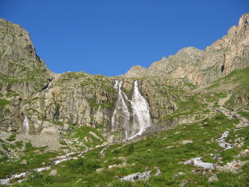
Among the natural objects of the park,
the following deserve attention: lakes of glacial origin (Mikelay,
Gularsky, Bartuyskoye, Mazaskatsad, etc.), numerous waterfalls
(Galdoridon, Taimazi, Soldier on the Orsdon (Ursdon) River, Devil's Mill
on the Kharesidon River, Gavized on the left tributary of the river.
Kharesidon - the Gavized River, etc.), giant boulders (for example, in
the Fastag Gorge), glaciers (Karaugomsky, Tana, 13 glaciers of the
Khaznidon river basin, 34 - the Urukh river, 26 - the Aygamugidon river,
etc.), gorges (Bilagidon, Khare, Gebidon, Karaugom and Wallagkom),
mountain peatlands (Chifandzar, Khare and Kubus), etc.
List of
towers located within the boundaries of the park and its buffer zone
In the village of Ahsau
Telakurov Tower;
Tower of the Tegaevs;
Tower of the Buzoevs;
Towers of the Tsaliyevs, Sarakaevs and Ogoevs.
In the village of Upper Fasnal
Kubatiev Tower;
Tukhaev tower.
In the village of Kamata
Tower of the Kertibievs.
In the
village of Kusu
Taymazov Tower;
Tower of the Kantemirovs.
In the village of Makhchesk
Tower of the Abisalovs.
In the
village of Stur Digora
Khaimanov tower.
In the village of
Wakats (Vakats)
Tower of the Mindzaevs;
Tsakoev tower.
The national park provides reception of excursion and tourist groups (5-7 people) for ecological, scientific and educational tourism at undeveloped bases in the Aygamugidon and Khare gorges. Visitors can also stay at the recreation centers of Rostelmash, Dzinaga and the alpine camps of the Taganrog Radio Engineering Institute and Koma-Art. Routes for mountain tourists are laid along the gorges and through the passes, the peaks of the Sugan, Labodinsky, Karaugomsky massifs are very popular with climbers.