11 largest cities of Russia
Moscow
St.
Petersburg
Novosibirsk
Yekaterinburg
Nizhny
Novgorod
Kazan
Chelyabinsk
Omsk
Samara
Rostov-on-Don
Krasnodar
Location: Kungur, Permskiy Kray Map
Earliest settlement: VII-IX centuries, Lomovatov culture
Official site
Kungur Ice Cave is located in Kungur of Permskiy Kray in Russia. The cave was inhabited
since at least 7th century AD by the people of the Lomovatov culture.
The Kungur Ice Cave is one of the most popular attractions in the
Urals. Together with Ice Mountain, it forms a historical and natural
complex of regional significance (in the USSR - a reserve of union
significance). The cave is located in the Perm Territory, on the
right bank of the Sylva River on the outskirts of the city of Kungur
in the village of Filippovka, 100 km from Perm.
One of the
largest karst caves in the European part of Russia, the seventh
gypsum cave in the world in length. The length of the cave is about
5700 m, of which 1500 m is equipped for tourists. The air
temperature in the center of the cave is from +5 ° C to −2 ° C, the
relative humidity in the center of the cave is 100%. Kungurskaya
cave contains 58 grottoes, 70 lakes, 146 so-called. "Organ pipes"
(the highest is in the Etherny grotto, 22 m) - high mines, reaching
almost to the surface. The age of the cave is estimated at 10-12
thousand years.
First written mentions
The Kungur
Cave has been known since time immemorial. In 1703, by decree of
Peter I, the famous geographer and cartographer of that time Semyon
Remezov and his son were sent from Tobolsk to Kungur to draw up a
drawing of the lands of the Kungur district. They made a map of the
county and a path to the Great Underground Lake. Remezov in 1703
drew up a plan of the cave. S. Remezov found in it pillars that
supported the vaults, crosses installed on stones, an icon. There
were gypsum kilns in front of the entrance.
Later, the Ice
Cave was visited twice in 1720 and 1736 by V. N. Tatishchev, who in
his work "The Legend of the Mammoth Beast" in 1736 explained that by
the giant elephant that allegedly dug the cave, the locals meant an
extinct mammoth. In this work, he was the first to correctly explain
the origin of the underground voids of the Kungur cave and described
his experiments to confirm his theory. Tatishchev in 1736 drew up a
detailed plan of the cave, now lost. In 1770 the way to the Big Lake
was described by I. I. Lepyokhin. Later famous scientists I. Gmelin,
M. Ya. Kittary wrote about the cave. In 1859, artists Ya.M.
Ikonnikov and Golovin visited the cave and left sketches of it. In
Soviet times, Professor G. A. Maksimovich and others wrote about the
cave. In 1934-35, the exact plan of the cave was drawn up by the
expedition of NM Pereslegin. In the same years, the expedition of
"Gidrostroyproekt" explored the far part of the underground
labyrinth. In 1948, a scientific station was created at the cave,
where the famous researchers of the Kungur cave V. Lukin and E.
Dorofeev worked. Since 1952, the study of the cave has been carried
out by employees of the stationary of the USSR Academy of Sciences.
Pre-revolutionary period
The history of the Kungur cave is
closely connected with the emergence and development of Kungur. The
city was originally founded in 1648 at the confluence of the Kungur
River into the Iren River, and in 1663, after the Bashkir uprising,
it was moved to the mouth of the latter. According to legend, the
first Russian settlers fled in the cave from the raids of the Tatars
and Bashkirs. In the 19th century, excursions of the curious from
Kungur, Perm and remote cities were not a rare event. In this case,
guides were usually hired from the peasants with. Bannoi (now
Filippovka).
Much credit for the popularization of the cave
belongs to the native of Kungur, A.T. Khlebnikov, who made an
adventurous journey through Japan to America and lived abroad for
several years. In 1914, he rented a plot with a cave from the local
peasant community, settled at the entrance, distributed advertising
albums, posters and led excursions.
Soviet time
In 1933,
the excursion base at the cave already had a room for an overnight
stay. Funds were allocated for the improvement of underground
passages. In 1937, shortly before visiting the cave with an
excursion of the XVII International Geological Congress, a 40 m long
tunnel was made into the Diamond Grotto. The number of sightseers
gradually increased. Among the visitors to the cave were M. I.
Kalinin, marshals V. K. Blucher, G. K. Zhukov, famous scientists A.
E. Fersman, D. V. Nalivkin.
Since 1948, the protection of the
Kungurskaya cave and the service of excursions have been carried out
by a karst-speleological station, created by the Lomonosov Moscow
State University and later transferred to the Ural branch of the
USSR Academy of Sciences. Since 1969, the Perm Regional Council for
Tourism and Excursions has taken over the service of tourists. In
the following years, an asphalt road was built to the cave, and a
109 m long tunnel exit from the Vyshka grotto was made. At that
time, the head of the study of the Kungur cave was the hospital of
the Ural Scientific Center of the USSR Academy of Sciences.
Long-term observations at underground meteorological and gauging
posts made it possible to calculate the heat exchange of the cave,
the amount of evaporation and condensation of moisture during winter
and summer air circulation, and to find the relationship between the
levels of Sylva and underground lakes. A new instrumental plan of
the cave was drawn up, its total length reached 5.6 km.
With the development of geophysical research, the cave has become a testing ground for new instruments and methods. To detect underground passages from the surface, geophysicists of the long-distance transmission department of the Teploelektroproekt Institute, Moscow and Perm Universities used electrical prospecting, areal electrical profiling, vertical and circular electrical probing, and natural electric field measurements. The Institute of Geophysics of the Ural Scientific Center of the USSR Academy of Sciences conducted gravimetric and magnetic surveys. In the cave, radio wave transmission, microseismic prospecting, and registration of cosmic radiation were used to detect undiscovered cavities. In 1966, the Institute of Geophysics of the Ural Scientific Center of the Academy of Sciences of the USSR equipped the Kungur tilt-measuring station underground to study the movements of the earth's crust and individual rock blocks using highly sensitive horizontal pendulums. For ten years, the tilts and shaking of the earth's crust were continuously recorded on photographic paper. Automation came to the service of researchers. Self-recording recorders of groundwater level, temperature, humidity, atmospheric pressure are installed in the grottoes, with the help of remote meters, the amount of seeping water is taken into account.
At the foot of the steep southern slope, on the banks
of the Sylva, hidden by the greenery of the park, there is an
entrance to the cave - a concrete tunnel. To the east of the tunnel,
in a cliff above the abandoned natural entrance to the cave, gypsum
and anhydrite of the upper (Irene) horizon of the Kungurian stage
are exposed, interbedded with packs of limestone and dolomite. These
rocks, which mainly make up the Ice Mountain, have a thickness of up
to 60 m. The gypsum is overlain by a layer of loose deposits
consisting of fragments of limestone and dolomite with clay filler.
Even higher, there are sandy-clayey deposits of the ancient terrace.
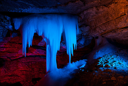
In the part of the cave closest to the exit, ice cover on the floor
and ice crystals on the vaults are preserved all year round.
More than 130 cylindrical channels are known in the roof of the cave
- "organ pipes" with a diameter of up to 3-9 m and a height of up to
20 m. One can often see cone-shaped clay-block debris under the pipe
mouths.
In the Perm Cis-Urals, more than a hundred
caves in sulphate rocks are known, but the size of the karst
cavities and the coefficient of internal karst content within their
boundaries cannot be compared with the Kungurskaya cave. Hence, we
can conclude that the latter was formed in especially favorable
conditions.
Considering the geological map of Kungur, one can
see that the cave is located at the contact of the lower
"Filippovsky" horizon of the Kungurian stage, composed of limestones
and dolomites, and the upper (Irene) horizon, composed mainly of
gypsum and anhydrite. The boundary between the horizons at the
entrance to the Kungur cave runs at a depth of about six meters
below the Sylva level.
From observations in the Kungur and
other regions of the Cis-Urals, it is known that the karst content
of sulfate rocks in plan and on transverse profiles sharply
increases at the boundary with carbonate strata. The increase in
karst content is explained by the influx of low-mineralized
hydrocarbonate-calcium waters from carbonate strata into readily
soluble sulfate rocks.
Karsting also increases in the zone of
periodic fluctuations of groundwater. The amplitude of these
fluctuations in the Kungur Ice Cave reaches three to four meters
during spring floods. Low-mineralized river waters, invading the
coastal massifs, dissolve and then carry up to 2 g / l of calcium
sulfate into rivers. This means that the expansion of the cave
galleries at the present time occurs mainly during periods of
floods. The concentration of karst at the intersection of the river
level with the plane of separation of the carbonate and sulfate
strata of the Kungurian stage helps us to reconstruct the history of
the formation of the Kungur cave.
Horizontal platforms on the vaults, fixing high
water levels, are found up to absolute elevations of 119-120 meters.
At the same height, there are the ceilings of the Central, Coral and
other grottoes of the cave, not affected by the collapse.
Consequently, underground galleries began to form at a time when the
r. During floods, the Sylva rose 0.5-1 meters above the surface of
the first terrace above the floodplain. During floods, river waters
and underground waters are now approaching this level, as indicated
by leaves and stems of grasses left by the water in the cracks and
niches of the cave walls. According to archaeological data, the
first terrace above the floodplain was formed in the 8-7th
millennium BC. e., the age of the galleries of the Kungur cave known
to us also does not exceed 10 thousand years. Older floors,
corresponding to terraces 2-4, are unknown. Apparently, they did not
have significant development and were buried as a result of roof
collapses. During the formation of these terraces, the contact
between the Iren and Filippov horizons at the river level was
located several hundred meters to the east. Therefore, underground
galleries, comparable in size to the well-known galleries of the
Kungur Cave, were located here and were later destroyed along with
the gypsum enclosing them.
Within the Ice Mountain,
apparently, there was one more ancient tier of underground cavities
located below the modern level of Sylva. In the Pliocene, when the
territory of the Cis-Urals experienced epeirogenic movements of
considerable amplitude, the channel of the Sylva in the Kungur
region deepened below the present level. The most ancient galleries
of the Kungurskaya cave date back to the formation of this
overburdened valley. At the contact of the Irene and Filippov
horizons, these galleries were large in size. They were filled with
fragments of gypsum, as well as dolomites, which lie 20-25 m above
the Sylva level, which indicates a significant height of the
collapse arches. However, no sand and gravel material was found from
the deposits of Pliocene terraces. Consequently, there were no
through channels in the cave roof.
The subsequent subsidence
of the area was accompanied by the filling of the Sylva valley with
sandy-clayey and gravel deposits. The layers of gypsum and anhydrite
in the vaults of the galleries, as well as in the pillars between
them, experienced folded and fault deformations. Coarse deposits in
ancient cavities as a result of compaction and plastic flow of
gypsum turned into rock - karst breccia. Such breccias, fancifully
eaten away by water, can be seen in the vaults of the Sculptural and
other grottoes of the Kungur cave. The ancient gallery can be traced
from Ruins Grotto to Coral Grotto. The steep and high slope of the
Ice Mountain, undermined at the base by karst waters, is slowly
shifting towards the erosional incision. At the same time, there is
an opening of tectonic cracks in two directions, along which a
lattice system of karst cavities was formed. The formation and
long-term preservation of large voids with high avalanches is
favored by the significant height of the Ice Mountain and its
plaster base.
According to its formation, the cave belongs to
the lake, not the river type - in other words, the cave was not
formed as a result of the action of a concentrated underground
watercourse
Ice mountain
The above-cave section of Ice
Mountain is also a natural monument and an excursion object. The
relief of this area clearly shows the destructive effect of
groundwater on readily soluble gypsum and anhydrite.
The
surface of the Ice Mountain is dotted with cone-shaped and
saucer-shaped karst depressions. Their size in plan reaches 100 m,
depth - up to 15 m. On the slopes of karst depressions there are
outcrops of gypsum, and at the bottom - ponors, through which snow
and storm waters penetrate into the thickness of sulfate rocks. Some
of the depressions flooded and turned into karst lakes and swamps.
Within the boundaries of Ice Mountain, on an area of 10,000 m2,
there are approximately 3,000 depressions. Fresh sinkholes are found
every year, which often appear on the bottom and slopes of old karst
depressions.
The uneven relief of Ice Mountain explains the
extreme diversity of the soil cover and vegetation. On the southern
slope of the mountain, species are widespread that have adapted to
the abundance of gypsum in the soil. Here, relict steppe and
mountain-steppe vegetation found refuge. Silvery threads of feather
grass sway in the wind, spreading along the slope. In the second
half of summer, blue balls of "Adam's head" (mordovnik) bloom, there
are desert oats, steppe sage, naked catnip, swing high, Siberian
cornflower, cold and silky wormwood, Danish astragalus and many
other steppe plants. The Ice Mountain with its birch groves among
the fields is part of the island Kungur forest-steppe.
Climate
Numerous organ pipes and crevices,
piercing the roof of the cave 60-80 m thick, contribute to the
intense seasonal air draft. In winter, it is directed from the
entrance to the depths of Ice Mountain, in summer, the movement is
opposite. In winter, the walls of the first grottoes, Brilliant and
Polar, are cooled to -10 °, in severe frosts, the air temperature
drops to -30 °. It gets warmer in the depths of the cave. The
chilling wind blowing in the entrance tunnel turns into a gentle
refreshing breeze. Having warmed up from contact with the stone
walls of the grottoes to a temperature of + 5 °, the air rises
through the crevices and organ pipes to the surface. In some
funnels, thawed patches form among the snow. Throughout the winter,
the cave accumulates cold, giving off heat to the atmosphere with
ascending air currents. It is estimated that the total heat removal
in winter reaches 2.14 million kcal / day.
In the summer
period, the descending air draft is accompanied by heat
accumulation, mainly in the above-cave channels and cracks. The
total heat inflow in summer is 1.5 million kcal / day. By closing
the tunnel doors for the summer, they artificially reduce air draft
and keep the cold.
The relative humidity in the caves is
90-100%. At the intersection of underground galleries and at the
entrance to large grottoes, where air currents with different
temperatures mix, intense moisture condensation occurs. In the Coral
Grotto, in summer and winter, the vaults and the booth of the
meteorological post shine from the settled moisture. Large drops of
water continually break off the protrusions of the vault. But the
most intense condensation occurs not in the cave, but in the cracks
and voids of the roof. Mixing with moisture filtering through the
mantle loam, condensation water seeps back into the cave. Drops from
the vaults do not stop even in cold weather.
In the grottoes
Brillianty, Polyarny, Vyshka, moist cave air enters the main gallery
from the side passages, which, when cooled, leaves frost on the
arches. Ice crystals grow throughout the winter, becoming more
complex, and, depending on the temperature, take the form of petals,
trays, six-sector funnels, rectangular cells, needles.
In
winter, a sharp difference in air temperature near the floor and
ceiling is found in the cave. In the Cross grotto the difference is
4 °, in the Ruins grotto - 2.4 °. Drops of water, falling from the
vault, fall, freezing on the floor in the form of ice columns -
stalagmites. When the temperature also drops below 0 ° under the
arches, icicles - stalactites - begin to grow. Stalactites and
stalagmites grow especially intensively in spring, during the period
of snow melting on Ice Mountain. Perennial ice covers the floor of
the grottoes of the Brilliant, Polar, Dante, Krestovy with a layer
reaching a thickness of 2 m. The area of distribution of perennial
ice is about 500 m², and their volume is 350 m³. They arose mainly
during periods of intense warming, when water seeped from above
through cracks, and in recent years they are replenished due to
falling ice crystals. In some areas, perennial ice is evaporated by
a stream of frosty air, in others, on the contrary, the ice cover
grows, reducing the cross-section of underground galleries, changing
the direction of air flows. In the flat ice wall, cut tens of years
ago between the Diamond and Polar grottoes, sightseers now see deep
niches - the result of ice evaporation. At the bottom of these
niches a layer of gypsum "flour" - a mineral residue that was once
dissolved in the seeping water - has settled.
Grottoes
The
well-known passages and grottoes of the Kungur Cave stretch along
the cracks in the north-west and north-east directions and form a
lattice system. Each branch is a string of grotto extensions linked
by narrow corridors. The total length of the examined passages is
5.6 km. The grottoes of the Giant, Geographers and others reach 40 m
in width with the height of the avalanches up to 10 m. The total
volume of the voids is about 100 thousand m³. The same volume is
also occupied by fallen boulders, clay, underground reservoirs and
ice.
The cave has 58 grottoes. For tourists, you can walk
along the Big Circle or the Small Circle. In most grottoes, the
temperature is about zero, the ecosystem is quite sterile (the
content of bacteria in the air is about 300 per m³). There are some
caves, the temperature of which remains below zero even in summer,
such as the Vyshka Grotto (−17 ° C) or the Diamond Grotto (−2 ° C).
In the Meteor Grotto, the illumination gives the impression of a
passing meteor. The largest is the Geographers' grotto - 50 thousand
m3, on the tourist route - the Giant's grotto - 45 thousand m3.
Lakes
In total, the cave has 70 lakes, the largest lake (the
Big Underground Lake) has a volume of 1300 m³, an area of 1460 m²,
and a depth of up to 5 m. In the lakes, there are Khlebnikov's
amphipods (Crangonyx chlebnikovi) and small frogs.
Drilling holes under the silty sediments at the
bottom of the lake open up the dolomites of the Filippov horizon.
Dolomite beds that are poorly soluble in water restrict cavity
growth. This explains approximately the same limiting depth of
different lakes.
In some periods, the level of the lakes is
0.1-0.4 m higher than the water level in Sylva. However, in the
well-known galleries of the cave, the slope of the underground
waters is directed not towards the river, as one would expect, but
deep into the Ice Mountain, towards the Geographers' grotto. A
stream flows through the cave to the lake in this grotto. Probably
the Grotto of Geographers has a connection with unknown galleries
that approach the river downstream.
The water temperature of
the cave lakes changes with the air temperature. In 1980, in the Big
Lake, it varied from + 5 ° in winter to + 5.2 ° in summer, in the
Long Grotto - from +3.7 to + 4 °. Ice appears on the lakes of the
Velikan Grotto in winter, and the lakes in the Vyshka Grotto in the
winter of 1973 froze to the bottom, and only the flood waters during
the 1979 flood melted the ice.
For almost the whole year, the
water of underground lakes has a mineralization close to full
saturation with gypsum - 2.1-2.2 g / l. During evaporation, as well
as due to the influx of water of a different composition, crystals
of calcite and gypsum fall out of the supersaturated solution. On
the surface of the lakes, spots of accrete crystals are formed, and
in some lakes a solid crust, similar to muddy ice, grows.
Floods
During floods on the river. In Sylve, the water level in
the cave lakes rises by 0.8-1.6 m and more. The peak of the flood in
the cave is 5-11 days late compared to the river. At an average
flood height, the lakes remain transparent. During the famous flood
in 1979 in Kungur, the Sylva level rose by almost 8 m, up to 120.74
m near the cave. The water broke through some dams and part of the
city was flooded. The entrance to the cave was filled with clay in
time. However, the water found a detour where the river comes close
to the gypsum steeps. Filtered through the blockages, the river
waters penetrated into the Vyshka grotto and flooded the low areas
of the floor. From the brought heat, ice crystals melted before our
eyes, crumbled from the arches. A stream of muddy water rushed into
the Giant, Long grottoes and further into the depths of the cave.
The lakes merged, new ones appeared where they were not. The
grottoes were half flooded. The groundwater level rose by 4 m. The
excursion route from the Cross grotto to the Big Lake and the way
back turned out to be under water. Through the mud block, water also
penetrated into the entrance tunnel and formed ice on the floor. The
drop in groundwater level lasted for a month. The cave was closed to
sightseers. After the water left, a layer of silty sediment remained
on the floor, which did not dry out in the humid atmosphere of the
cave, some debris slipped down, blocking the path.
The
invasion of river waters with a salinity of 0.25 g / l is
accompanied by intensive dissolution and removal of sulfate rocks.
The aggressiveness of the water is especially great at the beginning
of the path, where filtration occurs through blocky deposits. After
the 1979 flood, the site of absorption of river waters was marked by
a large landslide that arose over the newly formed cavity.
Before, during floods, the access of river waters to the cave was so
free that it allowed large fish to swim. Their skeletons have been
repeatedly found in the depressions of the clay floor.
It is
known that the length of many caves in the Soviet Union as a result
of complex speleological research has increased many times. The
total length of the galleries of the Kungurskaya Cave from 1947 to
1979 increased only from 4.8 to 5.6 km. Many of its branches come to
an end in front of rubble of large boulders, which are impossible to
pass without explosions. The use of explosives is not only
associated with high costs, but is often impossible due to the
insufficient strength of gypsum vaults.
The plan of the cave,
drawn by S. Remezov, shows a gallery to the east of the old
entrance, ending in a grotto with "natural stone steps". In the old
descriptions of the gallery, up to six grottoes are highlighted.
There are also some indications that the famous galleries of the
Kungurskaya cave continue northward towards the hydrogeological
watershed and westward along the right bank of the Sylva. For
example, inside the block debris that close the continuation of the
galleries, there is a movement of air that deflects the candle
flame. When combining the detailed plans of the cave and Ice
Mountain, it is easy to see that the chains of sinkholes stretch to
the north and west on the continuation of the explored galleries.
With the help of electrical prospecting, unknown voids were outlined
in the same directions. Of greatest interest for underground
exploration is a section of a birch grove to the west of the Kungur
settlement. The accumulation of large sinkholes with gypsum outcrops
indicates the presence of significant voids in the depth.
The
second promising area for searching for underground passages is
located on the northwestern edge of Ice Mountain, in the Baidarashki
tract. The surface of the earth is dotted with many karst
depressions of various shapes and sizes.
The opening of new galleries in the depths of the
Kungur Cave, as well as new caves within the boundaries of the Ice
Mountain, will increase the underground part of the reserve and, at
the same time, will expand the zone of strict protection.
To
preserve valuable excursion sites and karst landscape, it is
necessary to ensure the protection of the entire over-cave area, the
southern edge of the Ice Mountain, occupied by pine plantations and
a birch grove, and the Baidarashki tract. In the future, the
protected areas on Ice Mountain should be part of the reserve, which
includes the Spasskaya and Podkamennaya mountains.
Facts
The first "keeper" of the cave was A. T. Khlebnikov, who led
excursions from 1914 to 1951 and was engaged in researching the
cave.
According to one of the legends, in 1578-1579, Ermak's
detachment wintered in the vicinity of the cave before going to
Siberia.
In 1914, on July 13, the German princess Victoria von
Battenberg visited the cave with her daughter Louise. She was
brought up by her older sister, Empress Alexandra Fedorovna, the
wife of the last Russian Tsar Nicholas II.
In 2003, a documentary
film "The Great Ural and Yekaterinburg" was shot, which included a
story about the Kungurskaya cave.
On December 31, 1974, a group
of speleological students was forced to celebrate the New Year in
one of the grottoes of the cave, due to a sudden collapse of rocks,
which blocked the exit.