Lake Seliger is the largest lake in Central Russia, an important
center of recreational tourism. It is located mainly in the Tver
region, with a small part entering the Novgorod region. Every year,
many tourists come to Seliger for the picturesque local nature and
man-made attractions that are organically integrated into it.
Lake Seliger is the largest (260 sq. km.) of the system of Upper
Volga lakes located on the territory of the Ostashkovsky, Penovsky
and Selizharovsky districts of the Tver region and partly in the
Novgorod region. In total, there are more than 240 large and small
lakes. The uniqueness of Seliger lies in its geography. The lake,
which arose as a result of the influence of an ancient glacier, is a
system of reaches with numerous deep bays, channels and islands. As
a result, the relatively small lake has a total length of more than
500 km of the main coastline alone. The banks are winding, with
varied terrain and vegetation. Many islands and peninsulas. The
shores are represented by a wide variety of vegetation types, from
tundra- and forest-tundra-like moraine swamps to centuries-old pine
forests.
Thanks to its terrain and complex coastline, the
lake is very popular both among tourists traveling on various types
of boats and among fishermen. The lake is popular as a place of
recreational recreation, cultural, educational and pilgrimage
tourism.
The transport gate of the lake is Ostashkov, see Ostashkov#How to get there. Even in those rare cases when Ostashkov is not on the way (a car trip to the northern part of Seliger from St. Petersburg), the advice given there is correct, and Ostashkov cannot be avoided when traveling by public transport.
Moving around Seliger and the surrounding area by
public transport is quite difficult. Buses run relatively often only
along intercity routes from Ostashkov to Peno, Selizharovo and
Kuvshinovo, as well as to the village of Svetlitsa near the Nilova
Pustyn - there are at least several flights a day there. The rest of the
buses run in a radial direction (from cities to villages) and no more
than twice a day - in the morning and in the evening. There are three
main routes from Ostashkov - along the western shore of Seliger, along
the eastern shore and to the shore of Lake Volgo, the specific schedule
should be checked at the bus station. There is regular water
communication only from Ostashkov to the island of Gorodomlya (ZATO
Solnechny), but there are enough sightseeing and pleasure boats. The
railway bypasses Seliger on a tangent.
Tourist bases usually
offer a transfer to them from Ostashkov. Excursions are organized from
Ostashkov to a number of popular places (Source of the Volga, Shirkovo,
Okovetsky source), they can also be offered at some camp sites. When
traveling independently, it will be difficult to do without a personal
car, it is also possible to use a taxi, but it will be quite expensive.
Hitchhiking can be difficult due to the low volume of cars and their
high occupancy, but those drivers who have a free space are more likely
to pick you up.
Most of the roads on Seliger and in the vicinity
are of poor quality, many have a dirt surface (although sometimes it is
more pleasant to drive on primers than on completely broken asphalt).
You should not rely too much on roadside infrastructure; it is worth
refueling in Ostashkov, Selizharovo or Peno.
Ostashkov is located on the southern shore of the lake, and a separate article is devoted to its numerous sights.
A number of villages on the eastern bank of Seliger
and its environs are notable for the beautiful carvings on the facades
of most of the huts, and a significant part of the huts are brick. The
huts in the villages have a similar architecture, but differ in details
- we can say that a whole architectural style has formed on Seliger.
There is at least one such hut in almost every village, and the most
notable ones will be listed below.
1 Nilo-Stolobenskaya Hermitage,
Stolobny Island, near the village of Svetlitsa (10 km from Ostashkov to
the north in a straight line, 25 km by road). Perhaps the main brand of
Seliger, the grandiose ensemble of the monastery on one of the islands
of Seliger, connected to the shore by a dam. Pustyn, with its granite
embankments and predominantly classicist architecture, is reminiscent of
a corner of St. Petersburg, and the buildings of the monastery look like
they are standing on the water. The monastery arose at the end of the
16th century on the site of the grave of St. Nil Stolobensky, a miracle
worker and ascetic. The buildings of the monastery belong to different
eras and have undergone numerous alterations, but together they form a
single and integral ensemble. In Soviet times, the monastery was
noticeably dilapidated, but most of the buildings have already been
restored. It is worth noting that Nilova Pustyn in the summer,
especially on weekends, is an extremely popular place where there will
be a lot of tourists.
Monastery buildings: For those arriving from
the side of the lake in 1814, the Bishop's Quay was built in the form of
a front gate, and from the side of the shore in 1863 - the Svetlitskaya
Tower, both in the style of classicism. Directly behind the tower is a
statue of Nil Stolobensky - it is this image of the saint that has
become most widespread in iconography. To the left of it is a granite
embankment built in the middle of the 19th century. The largest and most
important of the temples of the monastery, the Cathedral of the
Epiphany, was built in 1821-1833 according to one of the projects that
participated in the competition for St. Isaac's Cathedral, and is truly
absolutely metropolitan in appearance. Impressive panoramas of Seliger,
islands and surrounding villages open up from the bell tower of the
cathedral. On different sides of the cathedral are the gate churches of
Peter and Paul and Nil Stolobensky built in the middle of the 18th
century. Next to the first of them is the Church of All Saints built in
1699, the oldest temple of the monastery, now in the process of
restoration. Of the residential and outbuildings, the building of the
refectory, which looks like an old Russian chamber, the first floor of
which was built in 1672, stands out, as well as very Petersburg-looking
residential buildings. Finally, on the cape that juts out into Seliger,
there is a very picturesque Baroque Holy Cross Church (1788), unlike the
rest of the buildings of the monastery.
How to get there: Unlike most
of the sights of Seliger, Nilova Pustyn can, in principle, be reached by
public transport - several times a week a bus runs from Ostashkov to
Svetlitsa, on the remaining days of the week it goes to the village of
Troeruchitsa, 6 km from the monastery. Almost all pleasure and
sightseeing boats also at least pass by it (and this trip is worth it,
because the view of the monastery from the water is really impressive).
By car, you need to leave Ostashkov towards Torzhok, immediately after
the bridge over the railway to the left (there is a sign).
2
Kravotyn (27 km from Ostashkov). An ancient village that has preserved
the layout of a medieval city. On a high hill between the lake and the
stream, there is a graveyard surrounded by walls and towers, on which is
the Vvedenskaya Church built in 1791 in the style traditional for
Seliger villages. From the "Kremlin" crooked streets with dense
buildings diverge, which in this village is one of the most beautiful on
Seliger. Now the village is essentially a holiday village, the permanent
population is very small.
3 Zaplavie (43 km from Ostashkov). A
village in the northeast corner of Seliger, where the houses are the
most beautiful in Seliger. Traditional white-washed brick huts with a
wooden mezzanine are the vast majority here, and the carvings and
architectural decor on them are amazing. Autographs of their creators
carved from wood have been preserved on many houses.
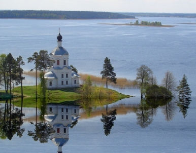
4 Trinity-Perevolok. A peninsula projecting into the lake, through a
narrow isthmus to which ships were usually dragged (hence the name).
Notable for the Trinity Church built in 1852 in the style of classicism,
unlike other temples of Seliger. The church was in a dilapidated state
for a long time (which even gave it a certain charm), but in 2014-2015
it was completely restored. Like many other Seliger temples, the view
from the water is especially interesting.
All the sights of the western coast are connected by
the Ostashkov-Svapusche highway and further to Demyansk.
5
Pyramid of Famine (before the fork to Peno and Volgoverkhovye). A
twenty-two-meter pyramid built in the 1990s, which, according to its
builders, has energy properties. It is not a landmark in the generally
accepted sense of the word, but the sight of such a structure in the
dense Seliger forests is quite amusing.
6 Nikolo-Rozhok (30 km from
Ostashkov). A high hill-peninsula on the western shore of Seliger with
the village of the same name on it. The place got its unusual name
because of its appearance, similar to a horn, and the location of the
once church of St. Nicholas the Wonderworker on it. Here was one of the
first settlements on Seliger and the first monastery in these places,
closed in 1764. The Assumption Church built in 1768 has been preserved.
The view of Nikolo-Rozhok from the water is very beautiful.
7 Monument "Cannon", near the village of Nepriye. The place from where
the offensive of the Soviet Army began in December 1941, marked with a
122-millimeter howitzer.
8 Yeltsy estate, vil. New Elts. The
former estate of one of the Tolstoy branches. The three-story manor
house, built in the style of classicism, strikes an unprecedented size
for the Tver region, although its facade is rather boring. Now the
building houses the Seliger Palace Hotel.
Volgoverkhovye is a
village 20 km west of Seliger, where the source of the Volga is located.
Despite the presence of more obvious candidates for the position of the
source of the Volga, popular rumor has always given preference to this
particular place. The entrance to the village is closed for cars, you
can stop right in front of the barrier. An "ecological path" with
characteristic vegetation and landscapes of the Upper Volga region leads
from the entrance to the village to the source. There is a set
traditional for the popular places of Seliger - standard souvenirs,
fish.
9 Source of the Volga. A small chapel at the place where a
stream begins from a spring on the edge of a swamp. A little further
downstream is a memorial stone erected in 1989. Next to it is the first
bridge across the Volga, 3 meters long. The great Russian river here has
a width of up to half a meter, so a popular entertainment for tourists
is to take pictures on its two banks at once.
10 Savior
Transfiguration Church of the Olgin Monastery. A very picturesquely
located red-brick church of the early 20th century, similar to
Ostashkov's Cathedral of the Sign. For a donation, you can climb the
bell tower.
11 Berezovskoye hillfort, vil. Zaluchye. Slavic
settlement of the 9th century, the former Novgorod trading city of
Berezovets, which fell into disrepair after the Polish-Lithuanian
intervention of the Time of Troubles. Now it is a hill up to 14 meters
high with a gentle top, which offers impressive views of Seliger. The
grave of Major General I.P. is also located on the settlement. Shevchuk
during the Great Patriotic War.
12 Tryaskoe (Silver) Lake (near the
village of Kartun). Forest lake, located near Seliger. The water in the
lake is denser and slightly warmer than the Seliger one, and also has an
interesting shade due to blue clay at the bottom, from which it got its
popular name. This is a popular route for boat trips.
Islands
13 City. The second largest island is Seliger, on which the Gethsemane
Skete of the Nile Desert was historically located, intended for hermits.
Now the island is located ZATO "Solnechny" (production of gyroscopes for
rocket technology). Entry to the island with passes, however, vouchers
for the hostel located on it are freely sold. Solnechny itself (2000
people) is a small village located in the forest.
14 Khachin.
The largest in area of the islands of Seliger, the size of an eighth of
it. We also inhabit it, but there are only a few remote villages with
rather unusual names on it. In addition, there are 13 internal lakes on
the island, as well as the Kopanka canal dug by the monks of the Nile
Desert, which shortens the path to the northwestern part of Seliger. May
2016 edit
Selizharovsky reach is the southwestern "offshoot" of
Seliger. The Selizharovka River flows from it, which then flows into the
Volga.
15 Rogozha (9 km from Ostashkov along the highway to Rzhev
and Torzhok). The village is interesting with the Church of the
Transfiguration built in 1770, built in the Baroque style using local
architectural traditions. Now the church houses a museum of Seliger
nature. Not far from the church there is a rather strong spring with
bright brown water from iron.
16 Verkhnie Kotitsy (15 km from
Ostashkov along the highway to Rzhev, not far from the fork of the Rzhev
and Torzhok highways). It is noteworthy for the Kazan Church built in
1803, picturesquely located on a hill above the water. This church is
also built in the Baroque style, using local traditions. The carved
iconostasis has been preserved.
Perhaps the most famous of the water routes on Seliger
is the Seliger Round the World. The route originates in Ostashkov, along
the Selizharovsky reach and the Selizharovka river, tourists descend to
the Volga (the village of Selizharovo). Then they climb up the Volga to
the Beishlot on Lake Volgo, then along the system of upper Volga lakes
they rise to the village of Kokovkino (not far from the source of the
Volga), and then on foot or on a ride they overcome 12 km to Seliger,
along which they return to Ostashkov. The route has a total length of
over 300 kilometers.
By car, Seliger can be driven around the
perimeter, this, along with stops in interesting places, will most
likely take 2-3 days.
Food establishments are mainly located in Ostashkov or camp sites. In rural shops, you can count on local pastries.
There are many different accommodation facilities in Ostashkov. In addition, the entire Seliger and neighboring lakes are literally “studded” with camp sites of various price categories. In summer, especially on weekends, it makes sense to book well in advance.
All four major mobile operators work. By default, there is a connection in large villages and on the Ostashkovsky reach. However, as of 2021, Tele 2 claims to have covered the entire Seliger and Upper Volga lakes with 4G at the same time.
The usual precautions for being outdoors in Central
Russia should be followed. Mosquitoes and ticks, although not like the
Siberian ones, can spoil the nerves, it is worth using an insect
repellant in the season. Encounters with wild animals are not too, but
likely, the same applies to vipers.
In winter, quite a lot (by
the standards of Central Russia) of snow falls in the lake area.
Lake Seliger begins to appear under the name Sereger
(Old Russian Seregzher) in Russian chronicles in the 12th-13th
centuries.
The name of Lake Seliger is most likely of
Baltic-Finnish origin, but its specific etymology remains a matter of
controversy. A. L. Pogodin and A. I. Popov, who supported him, argued
that the name goes back to Fin. Selkäjärvi "highly situated lake". J.
Kalima and M. Vasmer raise the name of the lake to Finn. Särkijärvi
"roach lake". Moreover, both versions are mutually exclusive and have
certain phonetic difficulties. The problem of the origin of the name of
Lake Seliger remains debatable also due to the difficulty of
distinguishing between the Baltic-Finnish and Baltic hydronymy in the
region.
The area of the lake is 260 km², including about 38
km² are islands (there are more than 160 of them on Seliger). The
largest is Khachin.
The area of the entire basin is 2275 km². The
greatest depth of Seliger is 24 meters, the average is 5.8 meters.
Seliger receives 110 tributaries, and only one river Selizharovka
flows from it. The lake lies at an altitude of 205 meters above sea
level and is of glacial origin. This explains its peculiar shape - it is
not a lake in the usual sense, but rather a chain of lakes stretching
from north to south for 100 km and interconnected by short narrow
channels. the coastline has a length of 528 kilometers and is
distinguished by indentation - capes overgrown with forests, deep
picturesque bays protruding into the land, various island shapes.
There are 24 stretches on Seliger, the largest are Polnovsky,
Ostashkovsky, Kravotynsky, Selizharovsky, Troitsky, Sosnitsky,
Nizhnekotitsky and Berezovsky.
About 30 species of fish live in Seliger (smelt,
bream, pike, pike perch, burbot, vendace, ide are of commercial
importance), work is underway to acclimatize eels, peled, and carp have
been acclimatized.
In the vicinity of Seliger, such mammals as
elk, wild boar, brown bear, wolf, fox, hare, squirrel, raccoon, marten,
beaver, bats have been preserved.
Of the birds there is a heron,
crane, duck, gull, hazel grouse, woodcock, magpie, woodpecker, thrush,
warbler, eagle.
Almost all the shores of the lake are bordered by
coastal aquatic vegetation: reeds and sedges on sandy banks, reeds,
cattails, pondweeds, white water lilies and yellow egg-pods in creeks
and bays.
Also on the shores of the lake you can find coniferous
trees, such as spruce, pine, larch. Wide-leaved plants such as oak,
birch, aspen are widespread.
Seliger is a navigable lake. Passenger transportation
is carried out by ships of the Moscow type (there are 4 ships with their
own names: Alexei Rodin, Captain Khorobrikh, Captain Markov, Baikonur),
Moskvich, OM, as well as ships of other types. There is a river station
in Ostashkov, and there are marinas on many islands. There are ferry
crossings on the lake.
Currently, there is one route of regular
water passenger traffic on Seliger: Ostashkov - Gorodomlya Island (in
winter, motor ships take a shortened route). The number of flights is
8-9 per day.
Since 2005, the Seliger youth forum has been held annually on the shore of the lake. Since 2005, the forum has been organized by the Nashi youth movement. Since 2009, the forum has been supervised jointly with the Federal Agency "Rosmolodezh". The large youth camp Seliger, which hosted young people on its site for ten years, was renamed Forum Park in 2015.
In 2017, the water of the lake turned out to be the cleanest in the Tver region among the controlled ones. The OCWHI indicator was 1.78 (class 2 - “lightly polluted”)