Length: 10 mi (16 km)
Area: 7,052 acres
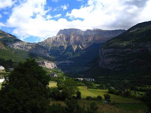
The Ordesa Valley is located in the central Pyrenees of Huesca,
Sobrarbe region, Aragon (Spain). It is listed as a World Heritage
Site by UNESCO.
This valley gave rise to the creation of the
Ordesa National Park on August 16, 1918. Years later, in 1982, it
would be expanded to create the Ordesa and Monte Perdido National
Park including the Monte Perdido massif, the Añisclo Canyon, the
Gorges of Escuaín and the head of the Pineta Valley.
In a
broad sense, the Ordesa Valley comprises a large area of small
valleys and ravines, plateaus and peaks (many over 3000 m high),
whose limits would be to the north the Monte Perdido-Mondarruego
ridge, which serves as the border with France. largely, to the south
the Sierra Custodia-Acuta ridge and to the west the confluence with
the head of the Ara Valley or Bujaruelo valley. This entire complex
forms a river basin, which through secondary valleys and waterfalls,
flows into the Ordesa Valley itself, through whose bottom the Arazas
River runs. The birth of this river occurs in the Ordesa valley
through the water that falls from the peaks forming the Cola de
Caballo waterfall, very famous in the valley for being the final
goal of the hiking route that bears its name.
In the high areas, a part of the North ridge stands out, from Monte
Perdido (3355 m) to Los Gabietos (3034 m), a whole succession of peaks
of more than 3000 m and in which an impressive crack opens, the "Brecha
of Roland", a "natural" passage between France and Spain and which
according to legend was opened by a blow from Roland's sword (how else
to explain such a natural phenomenon). A little south of the gap is the
Casteret Grotto, the interior of which is largely frozen, with ice
columns and waterfalls. It is currently closed to the public, and
permission from the park is required to enter.
The northern slope
descends in a succession of cirques and glacial valleys, with impressive
waterfalls, among which the Cotatuero Circus and waterfall stands out,
along whose crossing are the famous "Cotatuero pegs", simple metal bars
nailed to a wall. vertical walk and not suitable for people who suffer
from vertigo.. .
Access to the peaks of the Ordesa valley can be
done by vehicle from Torla (Huesca) through a forest track, although
access is restricted to authorized vehicles.
The Ordesa Valley itself is a spectacular glacial valley, with a
marked "U" shape, located to the southwest of the Monte Perdido Massif,
through whose bottom the Arazas River descends in a succession of
beautiful waterfalls. From the one where the valley begins, in the Circo
de Soaso, known as the "Cola de Caballo", and which opens into a white
fan that slides down the rock, passing through the Gradas de Soaso, a
succession of multiple stepped waterfalls, to the Strait and Cave
waterfalls, enormous waterfalls that have carved zigzag slides in the
limestone rock.
On the vertical walls of the valley, produced by
the different hardness of the rock layers exposed by the action of the
old glacier, several "strips" open up, small horizontal ledges that
allow you to explore the valley at altitude along dizzying and narrow
paths. Of these, the Senda de Cazadores stands out, which reaches up to
600 m in height with respect to the bottom and allows you to explore
practically the entire valley on its southern slope from a bird's eye
view, and the Faja de las Flores, highest and most vertiginous in the
area. north slope.