Location: A Guarda, Galicia Map
Constructed: 600- 200 BC
Museo de Monte de Santa Tecla
A Guarda
Tel. 986 61 4546
Open: Tue- Sun
Castro of Santa Trega is an ancient Celtic settlement situated near a little fishing port of A Guarda in a Galicia province in North- West Spain. A group of stone dwellings were constructed in 600 - 200 BC. However petroglyphs on the hill Santa Tecla where the settlement sits date back as early as 2000 BC. During Roman times Castro of Santa Trega was inhibited, but human presence went into decline and the site was completely abandoned. Museum of this archaeological site Museo de Monte de Santa Tecla is located on a hilltop nearby. It was declared a National Historic Artistic Monument in 1931 and also has the consideration of Cultural Interest.
In several of the rocks of the mountain where Castro of Santa Trega stands today archeologists found petroglyphs made 2,000 years before the construction of the fort, so, according to the thesis maintained by Antonio de la Peña Santos, director of the last systematic excavation campaigns in the eighties, settlement had a continued occupation between the 2000 B.C., until the first century AD. From that moment began a slow process of abandonment, which could have been interrupted with temporary sporadic reoccupations in late Roman times.
While it can be assumed that the inhabitants of La Guardia must have known about the existence of the remains of ancient buildings in the mountains for a long time, it should be emphasized that when Father Sarmiento visited La Guardia in 1745, he did not notice anything. mentioning them; it mentions a mountain, a hermit and his pilgrimage.
The first recorded discovery was a bronze sculpture of
Hercules in 1862, which was found by stonemasons working near the
hermitage. This sculpture was stolen from the museum in the 1970s.
In the second half of the 19th century, the ruins began to be
appreciated in due measure. The earliest written records of the
ruins can be found in the archaeological notes of Ramón López Garcia
in 18643 and in the testimony of Manuel Murguia in his 1888 Historia
de Galicia, which deduces from the ruins a relationship with the
Celtic race. family of Gauls.
Already in the 20th century,
the Pro-Monte de Santa Tecla Society was established in La Guardia,
which a year later contributed to the air conditioning work around
the hermit and the planning of the uphill access road. Work on this
road was found at the site known as Campo Redondo, the walls of
buildings and the foundations of the outer wall of the fort.
Faced with these discoveries, the society requested official
permission to begin systematic excavations at the site, a permit
that was issued on February 26, 1914, in which Ignacio Calvo
Rodriguez of the National Archaeological Museum was appointed chief
archaeologist.
From that moment on, the site began to appear
in the media. In the same year 1914, Canon Dominguez Fontela,
without any argument, attributed the remains of the "Iberian-Roman
civilization" and identified them with the historical Abobrica
mentioned by Pliny the Elder (a theory still held by some authors
today).
From 1914 to 1923, Ignacio Calvo was the head of the archaeological work, who covered the results of his work in several articles. The Pro-Monte Society is also involved in the area known as Fonte Nova. Calvo attributed ownership to the city from the early Bronze Age to Roman times. He was the first author to call it Quotation (following the example of Portuguese archeology) and talked about the possibility of identifying it with the mythical Monte Medulio, where the classical writers also found the mythical last and heroic resistance of the Galicians.
Between 1928 and
1933, the University of Valladolid professor Cayetano de Mergelina y
Luna, using the most advanced methods of the time, conducted a
series of archaeological campaigns focused mainly on the eastern
slope, exposing a large number of houses and other structures.
In 1945, he published the results of his work in a study
entitled La citania de Santa Tecla. La Guardia (Pontevedra) ".
Following most of the "invasion theories" of the time, he dated the
city to the 6th century occupation. c. C. to the 3rd century AD,
with a new occupation in the 5th century, and attributed to its
inhabitants a post-galstatic character of Celtic origin.
Despite the fact that in 1931 this
place was declared a national historical and artistic monument,
during these years this place suffered due to the expansion of the
ascent route and aggressive reforestation on the mountain, which
seriously worsened its condition.
Since 1933, the date of the
last campaign of Mergelina, the discovered remains have suffered
from the consequences of their abandonment, filled with vegetation.
This period of oblivion lasted until 1979.
During these
years, there were few and short-term interventions, such as the
intervention of Manuel Fernandez Rodriguez in the vicinity of the
building known as Casa Forestal, or the renovations carried out in
1965 and 1972 in two houses on both sides of the road, renovations
that are from a scientific point of view vision they pose serious
problems with fidelity, but in a short time they have become an icon
of Castro culture.
This stage of abandonment ended in 1979,
when Alfredo García Alain was in charge of cleaning and
strengthening the buildings closest to the road with the support of
the Ministry of Culture.
In 1983, with the financial
collaboration of the Junta de Galicia and the La Guardia city
council, the archaeologist Antonio de la Peña Santos led a team from
the Pontevedra Museum initiating a new period of systematic
excavations. This stage focused on the northern corner of the town.
The structures discovered in these and previous campaigns were
consolidated in these same years by a team led by Montserrat García
Lastra Merino.
Since 1988, no more archaeological work has
been carried out.
Already in 1996 the Ministry
of Culture and Sports announced in the press that they would
undertake actions for the socio-cultural use of this site. In July
2006, the Ministry announced a master plan for the Santa Tecla site,
which included the protection of the entire mountain, new
archaeological works, etc.
The visit to the mountain is not
free. On the other hand, the site lacks surveillance and the number
of unguided visitors causes the structures to suffer significant
deterioration.8
Every year, in August, the so-called Fiesta
del Monte takes place, declared of tourist interest.
Following classical authors such as Plinio
the Elder, Pomponio Mela, Appiano, Ptolemy ... the southwestern end
of present-day Galicia would be populated by the community of Grovii
or Grovios, whose most important city would be Castellum Tyde or
Tude, the current one You and. Following the theory of Antonio de la
Peña Santos:
The Galician forts were not, then, inhabited by
Celts in the strict sense but by Galicians only very remotely
related to what has been understood as continental Celtic cultures,
with which they perhaps shared a common linguistic background within
the Indo-European group.
Interpreting the archaeological
findings, it would be a town whose egalitarian structure (buildings
of similar sizes), with a non-bellicose peaceful character
(defensive systems more symbolic than effective) and whose agrarian
economy (proximity to fertile lands, approximately 1 or 2 km from
distance) but with a certain purchasing and commercial capacity
(abundant foreign products).
With time and as a result of the
reforms of the emperors of the Flavian dynasty and the progressive
introduction of the Roman system of exploitation, the inhabitants of
the town began a slow abandonment to settle in the new villages and
vici, located in the valleys and closer to the lands with the
highest productive value.
The importance
of cereals in the community's economy is evident in the numerous
stone manual mills found scattered throughout the excavated area,
most of the late circular mills, which some authors relate to Roman
influence.
Other instruments found such as axes, aixolas,
podons and bronze and iron sickles speak of agricultural work.
The large amounts of monofacial cut edges stand out, as are very
regular discoidal nodules found on the interior pavements of the
structures. The primitive design (similar to the Choppers, very
rudimentary and ancient lithic utensils, from the Lower Paleolithic)
and its possible usefulness cause strangeness among scholars.
The collection of wild fruits would be another source of
resources attested mainly in the remains of charred acorns that were
found.
For the study of organic remains, the shells are
essential, of which several were found at the site. In them it is
attested, in addition to the activity of exploitation of marine
resources, the livestock exploitation of the species of ovicápridae
(Ovis aries and Capra hircus), bovids (Bos taurus) and gallinaceae
(Gallus gallus). Highlights the absence of domestic pig.
In
relation to fishing, three bronze and two iron hooks were found, and
skeletal remains of specimens of the Sparidae, Gadidae, Labridade
and Morenidae families, species surely caught from the same
coastline. Of the remains from shellfish harvesting, more than half
belong to the common limpet (Patella vulgata), followed in quantity
by the mussel (Mytilus galloprovincialis), the common periwinkle
(Littorina littorea) and the toothed top (Monodonta lineata). It is
worth noting the absence of species typical of sandy areas.
Among the handicraft activities attested, the most widespread is
textiles, witnessed in the large number of loom weights found,
spindle loops13 and in the bronze needles with oval eye (all
straight except one). On the contrary, the findings related to
metallurgical activity are scarce, they are some pieces of crucible
and some stone molds.
The commercial activity must have been
of great importance, so much so that its own situation would be
determined by its logistical value for commercial maritime cabotage
as well as river navigation (going up the lower course of the Miño).
With the arrival of the Romans, the community was incorporated into
the complex maritime and land trading system of the Empire.
The discovery of a large quantity of ceramic remains of amphorae
confirms this trade. Most of these correspond to models used to
transport wine, other models would be for oil (mainly to serve as
fuel for skylights) and other merchandise.
The ceramic pieces
found, made of glass and other materials, reinforce the importance
of this trade with the Roman world (campaniform ceramics, from terra
sigillata). Finally, the almost one hundred coins found, mainly from
the governments of Augustus and Tiberius, a group from the
republican period and another set of copies minted in the Ebro
valley mints, bring us new information about the process of
incorporation into the new commercial system that this community was
to live.
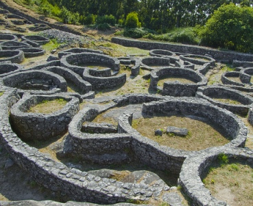
It is a castreño-roman town whose
occupation is situated within the castreña culture. Following the
last excavations made, its occupation dates from the 1st century BC
to the 1st century AD. C., in a period in which the process of
romanization of the peninsular northwest already began. Its
abandonment would coincide with the administrative reforms carried
out by the emperors of the Flavian Dynasty.
Despite this, the
construction system reflects construction techniques that are very
respectful of the Castro tradition (almost absolute predominance of
circular constructions over rectangular ones) and little influenced
by the Roman presence (always urbanistically speaking), although
more detailed studies may bring us closer data on this greater or
lesser Roman influence.
Of the totality of the excavated, a
very low percentage of the estimated size of the settlement, at
present only the northern area excavated in the 1980s and some
constructions in the highest area of the mountain can be visited.
The eastern zone or neighborhood excavated by Mergelina and the one
excavated by other teams are covered by bushes and trees and is
almost not perceptible. This state of abandonment makes its study
impossible. This, together with the inexistence of a planimetry of
the site, makes the study of the town as a whole very complicated.
It is delimited by a simple wall that houses an
extension of land with maximum axes of 700 meters (north-south) and
300 meters (east-west). Although these dimensions are not duly
confirmed and the current vision of the site is subject to the
systematic used in its archaeological study, the low percentage of
excavated land and the damage that took place since its discovery
(road, constructions on the summit , reforestation, etc.).
In
the event that subsequent studies confirm these dimensions, we would
be in the presence of one of the largest forts found so far both in
Galician lands and in northern Portugal.
In the
design of the wall, a function of delimitation of the land with
respect to its surroundings seems to prevail, as opposed to
defensive or dissuasive functions.
The wall was made in
quarrying with mud, not exceeding 160 cm in maximum thickness, lacks
foundations and so far no interior accesses have been found to them,
such as stairs or ramps.
The north gate opens at its
northeast end with a guardhouse on the right. Facing the southern
end, not visible today because of the vegetation, another door opens
with a right-angle access system.
The communication system in
the interior of the northern area is based on a patrol path attached
to the wall that surrounds the buildings.
Almost all of them have circular or oval plants and are free, not
sharing dividing walls with few exceptions. The few cabins with a
rectangular plan are also an exception and these have, for the most
part, arched corners.
The thickness of its walls is usually
quite uniform, about 40 cm on average, and with a better finish
facing the outside. The vast majority are small.
They sit
directly on the bedrock and their walls would be covered with a
mortar of lime and sand. Remains of pigmentation found would
indicate that the topcoats would be tinted with different colors.
Many of the cabins have an access hall that many authors
understand to be a Mediterranean influence adapted to the
characteristics of indigenous constructions.
Inside, some
have adjoining benches and the pavement in some cases is
terra-stepped and in others slab. In many of the entry thresholds
you can see the hinges, holes that the doors would fit into.
In this fort, a large number of monolithic jambs and lintels
decorated with geometric shapes, strung, intertwined, have been
found. They were also found, embedded in the walls, monolithic
cylindrical blocks of not very large dimensions and with one of
their faces decorated with geometric shapes such as spirals,
trisqueles, pinkish or pinwheels. Other elements, such as bases or
so-called moorings, have similar decorations and also
representations of animals.
This type of decoration,
according to Antonio de la Peña Santos:
highlights the existence
of an own and peculiar plastic of the castreño world, product of the
assimilation and re-elaboration of ornamental themes of
Mediterranean affiliation.
In relation to the roofing system,
the traditional theory that defends a coverage with a conical roof
supported by a central post is not endorsed by archaeological
findings, since the hole to fix the central post has not been found
and in that central place they are accustomed to find lareiras for
combustion. Due to this lack of reference to archaeological
evidence, it is possible to think of a covering system that
discharges directly onto the walls. In the same way, there is no
evidence to reject the possibility of a conical, flat or gabled
covering. On the other hand, if the use of plant materials for its
covering has been confirmed, reinforced by ropes tensioned by
perforated slabs (weights) that would hang from the limit.
As
is logical, not all the cabins would have a residential use, the
houses would be those of greater dimensions and with higher quality
rigging (some with those lintels and decorated elements already
mentioned), with a lobby and that have careful pavements of sablon
and with lareiras in the center of the room. In the hall you would
find a simple oven.
Another group of buildings, which could
be generically called warehouses, similar in number, would have uses
other than those for housing, so they present a less elaborate
typology and a less careful construction than the residential ones
and with a more banked threshold. Inside these constructions,
remains of amphorae, some mills, carving edges, etc. were found.
These constructions are adapted to the terrain with the help of
small terraced walls that delimit the space. The urban distribution
is characterized by the presence of groups of buildings forming
perfectly individualized sets. These are known as Family Units
(other authors speak of Patio Houses) made up of the corresponding
houses and warehouses structured around a small common patio, often
paved.
The urban planning of the site includes a complex
network of rainwater drainage channels located under the pavements
and plains, and sometimes on the surface, sculpted on the base rock
and covered with slabs. Sometimes these waters are channeled into
cisterns dug into the rock and lined with a waterproofing mortar.
This internal arrangement of the space appears conditioned by
the wall, the possible first element to be raised, which makes De La
Peña Santos think of the existence of a meticulous planning prior to
the construction of the cabins.
In the same area where the town was built, the
human presence has been verified approximately 2,000 years earlier.
Testimonies of this presence are the rock carvings left in various
locations of the later fort. Many of these petroglyphs were covered
by the structures erected at the time of the construction of the
castro.
Among the different representations that are still
visible today, geometric representations, the one known as Laja
Sagrada or Laja del Mapa stands out, which, located in the upper
part of the mountain, is composed of several spirals, concentric
circles and more or less parallel linear lines. Its discoverers
interpreted that it was a map of the mouth of the Miño, a hypothesis
that lacks scientific foundation. Close to it, between two walls
that partially cover it, there is another rock with similar
engravings.
What is evident is that these engravings have no
relationship with the castro since they are the product of a society
that developed 2,000 years earlier, in the final stage of the
Galician Neolithic.
In addition to the
aforementioned findings, a large number of ceramic remains found can
be highlighted, a fact common to the Galician forts, both indigenous
ceramics, characterized by having dark pastes modeled by hand or
with slow lathe, as well as numerous remains of other typical
varieties of the Roman world, such as bell-shaped pottery, with a
characteristic green glaze and parts of terra sigillata, with its
characteristic red glaze, as well as remains of the so-called common
Roman pottery. Fragments of a painted Iberian kalathos have also
been found. Pieces of skylights were also found among the ceramic
remains.
Also abundant were the finds of pieces of Roman
glass of various shapes and shades. Two fragmented basins of
polychrome glass of a very rare variety known as mosaic glass or
millefiori, typical of the oriental works of the first half of the
1st century AD, stand out. C., and that due to their quality can be
considered one of the best found so far in the Iberian Peninsula.
Finally, a large number of necklace beads made of glass and game
chips in the same material were also found, the latter may be linked
to the appearance of a Roman-type checkered stone board known as
tabula latrunculata.
Metallic finds, not very abundant in
these lands due to the acidity of the soil, are also present in the
site in the form of pieces of cauldrons, bronze sítulas and flat
bronze bladed knives that would form part of the domestic trousseau
of the inhabitants of the castro. .
The goldsmith also has
its presence with two auctions of torques made of gold plate. One of
them, of great artistic quality, presents a globular shape finished
in scotland and profuse geometric decoration and with a trisquel at
the base of the end. Bronze pendants of various shapes, remains of
bracelets and bangles also in bronze are part of the findings, as
well as Roman bronze rings.
Related to clothing, bronze
fibulae of various types have been found, omega, long arm, etc.
Finally, the few finds at the site of remains of weapons are
reduced to a few iron dart points, two bronze spindles, a Roman iron
dagger (pugio) with bronze rivets and remains of the scabbard, a
sword with antennas. finished in bitroncoconical buttons and iron
leaf. These last two are late pieces that are considered to have
been used more as elements of social distinction than strictly as
weapons themselves.
To all these elements should be added the
missing bronze statuette representing a Hercules and which was found
in the mid-nineteenth century near the hermitage.
In the years when Ignacio Calvo excavated in Santa Trega
(1914-1923), the findings of these works began to be exhibited in a
place in La Guardia, the seed of the museum that years later was
opened on the top of the mountain.
In 1943, the Pro-Monte
Society acquired a building in the upper part of the mountain that
was designed by the architect Antonio Palacios for use as a
restaurant. The pieces found in the excavations that made up the
current museum were transferred to this building, which was
inaugurated on July 23, 1953 with the presence of archaeologists
attending the III National Congress of Archeology.