Location: Canton of Valais Map
Length: 15 mi (24 km)
Thickness: 900 meters
Age: 60,000 years
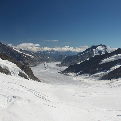
Grosser Aletsch Glacier or Great Aletsch Glacier is a massive sheet of ice in the Swiss Alps in the Canton of Valais. The origins of the Aletsch glacier are situated at an altitude of 4,000 m on the south side of the Jungfrau massif, where three large directions are generated, which converge a little further down on the so-called Concorde Square (Konkordiaplatz), an extension of some 6 km² that is properly considered the beginning of the Aletsch glacier. Grosser Aletsch Glacier reaches a length of 15 miles and its thickness in places reach a depth of 900 meters. Eventually it ends in the Whone valley where it gives beginning to the Massa River. Grosser Aletsch Glacier along with other small glaciers in the area are declared a UNESCO World Heritage site in 2001. There are under protection of Jungfrau- Aletsch Protected Area organization.
Physical characteristics
Its length is 23.6 kilometers (in December 2001) for an area of
117.6 km 2 (or 128 km 2 according to the Unesco Evaluation
Commission 1 ) and a mass of 27 billion tonnes of ice. Its middle
part advances at a speed of the order of 180 to 200 meters per year.
Nine peaks that surround it have more than 4000 meters of altitude
for an average height of 108 meters.
West Part
From the west, the Grosser Aletschfirn flows north of the
Aletschhorn and Lötschenlücke (3,173 meters), a pass that joins the
Lötschental and communicates with the Langgletscher . This part of
the glacier is supplied with snow and ice by three major snowfields
: the Ebnefluhfirn the Gletscherhornfirn and Kranzberfirn . These
three firestars start at about 3,800 meters above sea level. From
Ebnefluhfirn to Konkordiaplatz , the Aletschfirn is 9 kilometers
long with an average width of 1,500 meters.
Northwestern part
From the north-west, the Jungfraufirn from the east flank of the
Jungfrau and south of the Mönch is the shortest of the main
snowfields with 7 kilometers. It is then directly in the axis of the
glacial valley when it opens on Konkordiaplatz . It is bordered on
the west by Kranzberg and Trugberg on the east. At its highest
point, this firn reaches a width of 2 kilometers and is still 1
kilometer in its terminal part.
North Part
The area east of the Mönch and on the southwest flank of the Gross
Fiescherhorn gives birth to the Ewigschneefeld (literally the field
of eternal snow ). This snowfield, 8 kilometers long and 1.2
kilometers wide, continues its descent along the west of the
Grünhorn ridge . The east side of the latter gives birth to the
Fieschergletscher , a glacier that evolves almost parallel to that
of Aletsch but is shorter.
Konkordiaplatz
The three main firestones follow a slope of about 25 to 30%. The
Ewigschneefeld in its lower part is the most cracked of the three.
They lead to Konkordiaplatz ( Place de la Concorde ) where the ice
can reach a thickness of more than 900 meters. A small side firn 3
kilometers and 600 meters wide, the Grüneggfirn comes from the east
and joins the Konkordiaplatz at the height of the Konkordia huts. It
is also connected to the Fieschergletscher via the Grünhornlücke
(3,280 meters).
The ice accumulated at Konkordiaplatz , a vast flat area about 1.5
kilometers wide, moves about 180 meters a year to the southeast to
begin its long descent into the glacial valley.
Middle part
The glacier heads south-east at the foot of the Gross Wannenhorn
(in) to the east (3,906 meters) and the Dreieckhorn to the west
(3,811 meters). Once at Lake Märjelen to the east, the glacier turns
south and south-west with the Eggishorn blocking the path to the
south. Still at Lake Märjelen but to the west, the Aletschhorn
(4,193 meters) feeds another glacier, the Mittelaletschgletscher ,
which runs along a southeastern axis before reaching the Aletsch
Glacier. This connection is becoming thinner as a result of the
retreat so that the two glaciers should be separated in the future.
Lower part
The last part of the glacier is covered with lateral and medial
moraines. The tongue reaches an altitude of 1,560 meters, well below
the tree line. The Massa flows from the glacier and then descends
into gorges where its waters are captured and held in the dam
Gebidem to power a power plant. The river then joins the Rhone .
The Aletsch glacier is thick in its upper part but as it progresses
in the valley, the ice thickness decreases appreciably to reach only
150 meters in the final part.
Moraines
The characteristic moraines of the Aletsch Glacier, two parallel
bands, are dark and are almost in the middle of the glacier. They
follow the course of ice from Konkordiaplatz to the end of the ice
tongue. The moraine on the west has been named Kranzbergmoräne and
the east on the Trugbergmoräne .