Location: Canton of Bern Map
Gimmelwald is a city in Switzerland. It is located in the
district of Interlaken-Oberhasli District and canton of Canton de
Berne, in the central part of the country, 60 km southeast of Bern,
the capital of the country. Gimmelwald is located 1,380 meters above
sea level, and has 130 inhabitants.
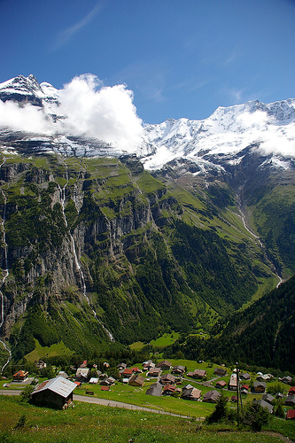
The land around
Gimmelwald is mostly mountainous. Gimmelwald is located in a valley.
The highest place in the area is Rotbrätt, 3,386 meters above sea
level, 3.6 km east of Gimmelwald. [narrative 2] Less than 2 people
per square kilometer. The nearest larger town is Frutigen, 19.2 km
west of Gimmelwald. Around the Gimmelwald. In the region around
Gimmelwald, mountains are incredibly common.
The climate is
tundra. The average temperature is −6 °C. The warmest month is July,
at 5 °C, and the coldest is January, at −16 °C. The average rainfall
is 1,585 millimeters per year. The wettest month is November, with
179 millimeters of rain, and the wettest is March, with 64
millimeters.
The place is first mentioned in 1346 in a bill of sale. Gimmelwald is
a Walser settlement and an Alemannic row village. The residents of
Lötschern are mentioned in the deed of sale. The oldest house was built
in 1658 in the Walser style. It was only with the construction of the
Stechelberg-Mürren-Schilthorn (LSMS) cable car in 1967 that Gimmelwald
was connected to the transport network. Previously, Gimmelwald was
difficult to reach on foot via Stechelberg or Mürren.
In 2019,
the old school building was transferred to a locally founded cooperative
with the aim of counteracting emigration with cooperative housing in
Gimmelwald.
You can reach Gimmelwald from Stechelberg with the LSMS cable car or on foot on a narrow footpath (2.7 kilometers long). There is also a road connection with neighboring Mürren, 2.3 kilometers away.
Together with Wengen, Mürren, Isenfluh, Stechelberg and
Lauterbrunnen, Gimmelwald belongs to the political municipality of
Lauterbrunnen. The parish also covers the entire valley.
Resident
In the 1930s, Gimmelwald reached its peak population. Because of the
economic crisis at the time, it was not easy to find work abroad either.
In this way, the family members made themselves useful in agriculture at
home.
Gimmelwald is part of the Jungfrau Region Tourism Association. A via ferrata between Mürren and Gimmelwald has been open since 2008. You can safely get from Mürren to Gimmelwald over rocks.