Location: Central Belt of Scotland Map
Constructed: 142- 154 AD
The Antonine Wall (from Latin Vallum Antonini "Wall of Antonine") was part of the British Limes. It was the second great rampart built by the Romans in northern Britain. The wood-earth fortification is less well-known than Hadrian's Wall, further south, which is made entirely of stone. Shortly before the middle of the 2nd century AD, the Emperor Antoninus Pius (138–161) abandoned this and began to build a new, temporary wall further north, which ran along the narrowest part of the British Isles. In this way he succeeded in expanding the province by about 160 kilometers to the north. However, the protection it was intended to provide from Caledonian raids was short-lived. It was abandoned again towards the end of the century, Hadrian's Wall was manned again and used for border surveillance until the beginning of the 5th century. The Antonine Wall was only once again occupied by Roman troops in the early 3rd century – for a short time.
The Antonine Wall stood in a topographically much more favorable position than its southern counterpart. The barrage was built at the geographically narrowest point (Central Belt) of Scotland, at Clota (Firth of Clyde) and Bodotria (Firth of Forth), across the Central Lowlands. It stood about 150 km north of Hadrian's Wall. This strategically favorable location was already recognized by Gnaeus Iulius Agricola and is still used today as a road. Its length of around 60 km (a little more than half of Hadrian's Wall) stretched from the westernmost fort of Old Kilpatrick, in Dunbartonshire, on the north bank of the Clyde to the easternmost fort of Carriden at Bridgeness on the Firth of Forth. From the southern heights of the Forth, Carron and Kelvin valleys it dominates the countryside and offers excellent views to the north. The exact course between Bridgeness and Carriden is still uncertain, but the most carefully worked out building inscriptions come from here. On the south bank of the Carron, the wall stretches over the basalt hills of Croy and Bar Hill to the Kilsyth Hills and the Campsie Fells. It crosses the Rivers Avon and Kelvin at Inveravon and Balmuildy Castles. In the western section, too, the wall was preferably built on higher ground (Kilpatrick Hills).
According to the current state of research, the Roman limits of the imperial period served primarily to regulate and monitor daily border traffic and to collect customs duties. In principle, this also applied to the plants in Great Britain. Temporarily he should probably take over the functions of Hadrian's Wall. This also brought you much closer to the settlement areas of the Highland tribes, which constantly threatened the province. The almost complete absence of approach obstacles such. B. stockades or the like, however, sheds a special light on this structure and ultimately on the overall conception of the policy of conquest of a ruler who never left Italy during his entire reign. The emperor's exact motives for building the wall are unclear. Shortly after assuming power, he apparently saw the need to reintegrate a larger area into the empire and secure it with a wall. Possibly this should dispel any doubts about his military competence. Thus Antoninus Pius, in the tradition of his militarily successful predecessors, was able to have himself acclaimed as imperator in 142. Whether that is why he held a triumphal procession in Rome is disputed, since the sources do not mention anything of the sort. With this, Antoninus set himself apart from Hadrian in a conspicuous manner, who had dispensed with such stagings.
Around 30 years after the invasion of Britain, the Romans under
Agricola invaded Scotland. Within seven years he had taken control of
much of the country. A few forts were built along the later line of the
Antonine Wall, others along the Gask Ridge in Perthshire. From the
mid-1980s AD, the Roman troops were withdrawn again because they were
more urgently needed elsewhere in the empire. Around AD 122, Emperor
Hadrian established the northern boundary at the Tyne-Solway Isthmus by
building Hadrian's Wall. After Hadrian's death, Antoninus Pius (AD
138–161) rose to the position of Roman Emperor. For strategic reasons,
tactical convenience or economic interests, Antoninus decided to
reoccupy part of those areas in Scotland which had formed the northern
border of the empire under Agricola in the 1st century AD. In the years
139-141 there were supposedly conflicts with the tribes living there. It
is possible that their territories should now be officially incorporated
into the Reich, since the Romanization was having an increasing effect
on them as well. During this time, however, there was also serious
unrest in the Lowlands because the traditional hillforts were cleared
under pressure from the Romans and the population had to move their
residences to the plains, where it was easier to control them. In such
uprisings, it was far more difficult for the army to intervene quickly
from Hadrian's Wall, far away.
However, the gain for Rome
(compared to the effort involved) was small, even if the reoccupation
brought the agriculturally more productive Votadinii territory back
under Roman rule. It is unlikely that major combat operations took place
as the Romans had already largely brought the area under their rule.
Since the army, instead of occupying all of Caledonia (Caledonia),
advanced only as far as the Forth-Clyde line, and the wall was not
raised in stone from the start, it is reasonable to assume that no
permanent occupation of this region was planned. The Wall nevertheless
represents an impressive achievement as its core structures were
completed within two years.
The army's advance was along several
roads in the Central Lowlands that had existed since the 1st century AD.
They were also secured by fort chains. The garrisons from the Pennine
forts also had to be used for the campaign. However, this mountain
country was not completely demilitarized. With the exception of a few
key positions, Hadrian's Wall was abandoned and the moats were made
passable with earthen dams. Only small remaining crews remained in the
wall forts or legionnaires were stationed there as replacements. Outpost
forts such as Birrens and High Rochester remained occupied or were
re-established, such as Risingham Fort at 205-208 Dere Street. In the
course of the erection of the wall, some forts from the time of
Agricola, such as e.g. B. Glenlochar and Raeburnfoot reoccupied or built
new small forts.
The construction of the wall lasted from 142 to
144 AD, after the governor Quintus Lollius Urbicus had occupied the area
north of Hadrian's Wall in the early years of the reign of Antoninus
Pius. Completion of the entire infrastructure of the border
fortifications probably took another twelve years. Beyond the Wall were
other outposts on the marching routes into northern Caledonia, roughly
as far north as Perth. On the north bank of the Clyde, a road led from
Old Kilpatrick to a harbor at Dumbarton. It was well outside the area
occupied by the Romans, which shows that the army also had the land in
front of the wall under control. Outposts were set up on the Tay to
secure the Five Peninsula and serve as an early warning system. From
Watling Lodge a road led to the old Gask Ridge forts of Bertha,
Strageath and Ardoch, which were also once again occupied by Roman
garrisons.
Despite the numerous temporary camps set up by the
Romans in the Lowlands along the main connecting roads, they were never
able to subjugate the Picts and Celts tribes living there in the long
term. As early as 155 the wall seems to have been abandoned for a short
time. Shortly thereafter, however, he was occupied again. Already around
160, before the death of Antoninus, a large part of the Roman troops
were moved back to Hadrian's Wall. Around 182, after only 40 years of
occupation, the last garrisons were withdrawn from the wall. The main
reason for this may not have been the pressure of the Caledonian tribes,
but rather the massive invasion of barbarian peoples on the Danube
border. After that, Roman soldiers only returned to this region in 208 –
under Emperor Septimius Severus; it is possible that the Antonine Wall
and its forts were temporarily manned again in the course of this
campaign. This could at least be the reason for the mention of a "Wall
of Severus" by later historians, which probably actually meant the
Antonine Wall.
The wall was mentioned in late antiquity by the
chroniclers Eutropius and Orosius, and in the early Middle Ages by the
Venerable Bede. In the Middle Ages, the remains of the wall and its
ditch were referred to as "Graham's Dyke" or "Grim's Dyke". Most of the
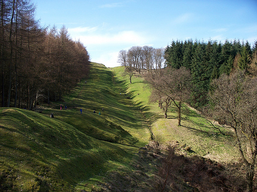
Antonine Wall has either been destroyed or eroded away over time, but
sections can still be clearly seen in the terrain at Bearsden,
Kirkintilloch, Twechar, Croy, Falkirk and Polmont north of Glasgow.
The reason for the creation of this fortified
limes was to advance the Roman defensive positions, considering that
the province of Britania was already safe, in order to guarantee its
defense, and incidentally submit to the hostile tribes that lived
between both walls, in the lands High in southern Caledonia . These
tribes of the Picts constituted a major threat because of their
hostility, to which their lands were ravaged and a large number of
their inhabitants imprisoned and deported to Germania .
The wall was not as solid as Adriano's, since it was formed by a
wall of peat and rammed earth instead of stone, although it had a
pit greater than the first and also had 19 forts and a military path
in its southern part . However, the fortification was abandoned
after the death of Emperor Antonino Pio, towards 162 , gradually
returning the northern tribes to descend. At the death of Emperor
Comfortable , possibly in 196 or 197 , when Governor Clodio Albino
withdrew much of his garrison by proclaiming himself Emperor and
moving to Lugdunum (present-day Lyon), the northern tribes staged a
major attack on the Roman borders on the island, which led in 208 to
Emperor Septimius Severus to reestablish legions in Antonino's wall,
also ordering wall repair operations, so sometimes it is cited as
"wall of Septimius Severus."
The Antonine Wall was constructed as Murus caespiticius, as a wall
using turf technology. As with Hadrian's Wall, the construction of the
approximately 37 Roman miles long Antonine Wall was modified several
times. Due to its relatively simple construction, significantly less
material was required. Compared to the barricade in the south, it was
much lower and less solidly fortified, but it was much shorter (60 km)
and easier to monitor due to its denser network of forts. According to
the building inscriptions, two units of length were used. West of
Castlehill, the Roman mile was used to indicate distance (4 miles). This
section was probably divided into ten lots of one Roman mile each. The
length of lots from Castlehill to Bridgeness was given in Roman feet.
The shorter distances measured there probably took into account the
difficult terrain.
The barrage essentially consisted of a 4.3
meter wide, unmortared stone foundation (consisting of a quarry stone
core with boarding on both sides), a dam made of turf bricks, approx.
three to four meters high and five meters wide with a battlement,
crowned with a wooden parapet made of palisade or wattle. The stone
foundations suggest that according to the original plans, the rampart,
like its southern counterpart, was also to be built entirely in stone,
but this was apparently later rejected. Steeply sloping terrain, as in
Bearsden, was set off in the form of steps; at Caddar, steps up to four
meters high artificially terraced the terrain. The foundation was kept
dry by drainage ditches. Different foundation and rampart widths in
sections are probably due to the construction work being carried out by
two construction crews. An average width of 50 meters in front of and
behind the border line was required for the construction of the wall.
Ideally, the soil suitable for material extraction was in the immediate
vicinity of the construction site. The turf cutting work involved
cutting out the blocks of earth, loading them (usually onto a soldier's
back), transporting them, unloading them and positioning them at the
designated place on the wall construction. The legions undoubtedly had
the most experience of such construction work, as illustrated by some of
the reliefs on Trajan's Column. A crescent-shaped lawn rake was also
part of the standard equipment of every Roman soldier in the 1st century
AD. The work of the Royal Engineers on Lunt Castle (Baginton,
Warwickshire), an experimental replica of a 1st century AD Roman fort,
and the study of information in military handbooks - which predated
mechanization - yielded a working time of about 10 minutes. The lawn
tile was fixed to the back with a rope sling for transport. However,
when working on the Lunt fort, two men were required just to lift the
bricks, and the turf bricks could easily break if you weren't careful.
Two men were probably also required for safe unloading and laying out.
At a distance of 37 to 46 meters, the wall was accompanied by a paved road to the south. It was five to eight meters wide, slightly arched in the middle to ensure better drainage and provided with drainage ditches on both sides. Its pavement consisted of several layers, larger stones as a foundation and a top layer of smaller stones and gravel on top. In heavily frequented sections it was paved with stone slabs. Usually, however, a layer of gravel and sand was simply piled up and compacted. Trees and bushes have been removed on both sides to reduce the risk of a surprise attack. In many camps it was integrated into the fortifications as a via principalis running from east to west. The road was intended to enable rapid troop movements without unforeseen obstacles on the east-west axis and was therefore closed to civilian traffic. At Duntocher, Cadder, Bar Hill and Bonnyside it appears to have been laid before the Wall was completed.
On its north side it was bordered by a pointed ditch as an approach obstacle, on its south side ran a well-developed road that may have served as a patrol route. The berm was six to nine meters wide. It averaged 12.2 meters wide and 3.5-4 meters deep. At Croy Hill it was interrupted by basalt rocks. His excavated material was piled up to form a dam on its north side. To pass it there must have been several earthworks or bridges to the north. One of these transitions could be detected at Watling Lodge.
The rampart was probably secured by 19 auxiliary forts, most of which
could be proven. Like Hadrian's Wall, the Antonine Wall was also
reinforced with a chain of larger and smaller forts that lay directly on
the wall. However, there was a greater structural diversity here. Cohort
forts, small forts, marching camps and other fortified areas were built
to secure it. Some of these fortifications were obviously erected before
the wall was completed. The best preserved fort is at Rough Castle. A
total of 15 wood-earth (peat) forts were built at intervals of two Roman
miles (about three kilometers) in the playing card shape typical of the
middle imperial period. The only exceptions were the Castlecary and
Balmuildy camps, which were surrounded by stone walls. The gates had
only one passage. All but three of the fortifications were oriented to
the north. At Newstead, where two units were stationed, a ditch
separated the retendura from the front of the fort. Perhaps this was to
separate the legionnaires from the auxiliaries. Access was also flanked
by two doors. An annex had been added to some of them. In Bearsden even
a bath building was included. The areas that are usually completely free
of buildings were otherwise probably used to accommodate supply wagons,
draft animals or workshops. The Bar Hill and Bearsden camps advanced
somewhat to the north. The last forts erected on the wall faced east.
Some of the forts were surrounded by several defensive moats. 27 yards
from the walls of Rough Castle were pits that may once have been riddled
with sharpened stakes and served as obstacles to approach.
Primary cont
The first six forts, the primary forts (PF), were built
at a distance of about 13 km. This corresponded to the distance that an
infantryman could cover in one day. However, the distances differ a
little from each other due to the partly different terrain. Some camps
in the western sector (Balmuildy, Mumrills, Old Kilpatrick) predated the
Wall's construction, as evidenced by some of the details of their walls.
Mumrills and Castlecary had been occupied by Roman soldiers even since
the days of Agricola. In the east, on the other hand, all the forts
first had to be rebuilt.
Secondary cont
In order to reduce the
distance between the forts to 3.2 km, a number of other forts were
founded a little later, the secondary forts (SF). However, these plants
were much smaller than the PF in terms of area. They were also not
provided with their own building for camp administration (principia)
and, like the mile forts on Hadrian's Wall, were probably commanded from
the neighboring PF. The forts at Rough Castle, Westerwood, Croy Hill,
Ceddar and probably Bearsden were probably successively built for this
purpose. This sequence is u. a. supported by observations at Dundocher.
Here an already existing small fort was included in the SF. In the west,
the deserted and much more dangerous staging ground for invaders,
Campsie Fells and Kilsyth Hills required larger numbers of troops.
Significantly fewer SFs were erected in the eastern section. Here the
protection of the apron by the forts on the Five Peninsula was
considered sufficient. But they were probably mainly intended to protect
the tribes allied with the Romans.
According to an inscription discovered in Carriden, settlements (vicus) may have developed around some of the larger forts over time, which, however, were self-governing and not under the guardianship of the military.
For a long time, researchers were of the opinion that - in contrast to Hadrian's Wall - no forts had been built on the Antonine Wall. However, the remains of seven Roman-era fortifications have now been identified as such. There were probably originally 40 of them on the wall. The small forts shortened the distance between the individual bases to 3.2 km. Her crew probably comprised no more than eight to twelve men. The interior structures were made of wood. The gate was to the south and consisted of a tower with a single passage. A northern passage did not exist. Only the forts of Wilderness Plantation and Duntocher were examined in detail. They probably arose at the same time as the Wall and the PFs. This assumption is supported by the rounded corners of Duntocher's and Cheddar's camps, which have the same (planned) rampart connection as the forts. Wilderness Plantation, Croy Hill, Seabegs and Kinneil, on the other hand, have been directly connected to the wall. They were probably built at the same time as the Antonine Wall. The best-known fort is at Kinneil House, at the east end of the wall, near Bo'ness. West of Bishopton, small forts at Lurg Moor and Outerwards guarded the south coast of the Clyde Estuary. A continuous barrier of the river bank with palisades, as on the Solway Firth, was not archaeologically detectable there.
Watchtowers that were attached to the wall at regular intervals have
not yet been found on the Antonine Wall. Maybe they decided not to build
them because of the many mile forts. However, three five meter by five
meter square stone platforms discovered near Croy Hill and Rough Castle
could be the foundations of signaling stations.
Garrison troops
The wall was secured by a force of around 7,000 men. The garrisons
consisted of legionary vexillations and auxiliary cohorts (auxilia). In
the outpost fort Bertha, two units are occupied, which were accommodated
there together. South of the wall there were mostly only vexillations in
the Lowlands forts that were supposed to secure the supply lines. Two
vexillations are also known for Newstead (Trimontium), which were also
stationed there together. Only one ala and a few partially mounted
auxiliary cohorts (cohors eqitata) are known of cavalry on the Antonine
Wall. The western flanks of the wall were secured by the cavalry unit
stationed at Bishopton Castle. She was in charge of the lower course of
the Clyde.
Only vexillations are mentioned on the inscriptions of Legio VI and
Legio XX. Those of the Legio II lack these clues. It was probably
assigned to build the wall with a full crew, while the other two were
mainly used to secure the British provinces and were assigned smaller
construction lots. The specimens found so far can be divided into two
geographical groups. Most of them are in excellent condition, suggesting
that they were taken down and buried before the Roman army left. The
differently formulated texts were probably given by the commanders of
the respective construction crews and name the reigning emperor, the
legion responsible for it and the length of the construction lot. On two
stones of the Legio VI with the wording "opus valli" it is expressly
pointed out that they carried out construction work on the wall. The
names of the acting governors and individual cohorts or centuries, as on
the centurial stones of Hadrian's Wall, are not given.
A
particularly carefully and lavishly designed example, found in 1868 on
Windmill Hill, near Bridgeness, at the eastern end of the Antonine Wall,
is now in the National Museum of Antiquities in Edinburgh. It was found
lying face down, as if hidden there on purpose. The stone tablet was
probably placed either on the north side or at the eastern end of the
wall. The inscription carved on it is dedicated to Antoninus Pius and
subsequently tells of the completion of the 4652 passus long section
from Bridgeness to the eastern end of the rampart by a vexillation of
Legio II. The inscription field is flanked by so-called peltae, small
infantry shields. The relief on the left shows a Roman cavalryman riding
down a group of hostile Britons, depicted as naked barbarians. The
relief on the right shows a ritual sacrificial scene, a so-called
suovetaurilia, in which a bull and a sheep are offered as an offering to
Mars, the god of war, on an altar.
Since 2008, the remains have been included in the UNESCO World
Heritage List as part of the European Limes. The entry also includes
other sections of the Roman border fortifications, Hadrian's Wall and
the Upper German-Rhaetian Limes; further sections in south-eastern
Europe are to follow.
The forts on the wall
Listing from West
to East
Bishopton Castle
Old Killpatrick Castle
Castle
Duntocher
Small Fort Cleddans
Castlehill Castle
Bearsden Castle
Summerston Smallfort
Castle Balmuildy
Smallfort Wilderness
Plantation
Castle Cadder
Small Fort Glasgow Bridge
Kirkintilloch Castle
Castle Auchendavy
Castle Bar Hill
Croy
Hill Castle
Westerwood Castle
Castlecary Castle
Small fort
Seabegs
Rough Castle
Watling Lodge Small Fort
Castle Camelon
Falkirk Castle
Mumrills Castle
Inveravon Castle
Small fort
Kinneil
Castle Carriden
Cramond Castle (Supply Storage)