Location: 12 mi (19 km) North- West of San Ignacio, Cayo District Map
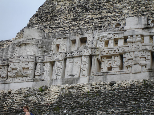
El Pilar is an ancient Mayan archeological site located 12 miles (19 km) North- West of San Ignacio, Cayo District. The current name of El Pilar Archaeological Site is a modern one. "El Pilar" in Spanish mean "watering basin". Its name is given due to the large abundance of water in the area. Many of the springs are hidden underground with Mayan tunnels leading to them. The Ancient Ancient Mayan name for this large city was forgotten. El Pilar was first settled around 800 BC and by 200BC it became a large metropolitan area. At its height El Pilar boasted a large population of at least 20,000 residents that lived in an area that covered over 120 acres or 50 hectares of 25 plazas of various sizes, religious and government buildings and hundreds of private residences where common people used to live.
The city grew from Middle Preclassic period (800
BC), with the first small temples and plazas identified in the main
eastern temple of Plaza Copal. The civic area was expanded, reaching
its greatest extent before 1000 AD. At its height in the Late
Classic, the total population of El Pilar is estimated to have
exceeded 180,000.
Ford and her team have excavated many of
the plazas, temples and palaces of the monumental civic area.
Surrounding the monuments is the residence that made up the ancient
Maya community. Tzunu’un, a residential unit discovered, mapped and
tested in 1984, became the focus of a major investigation that
excavated, exposed, and consolidated an elite Maya house. This is
the only archaeological house that the public has access to today.
Working with Master Maya forest gardeners, the team has developed a
forest garden around the house site. The forest gardens of El Pilar
are now maintained by the Maya farmers as part of the El Pilar
Forest Garden Network.