Location: Michoacán state Map
The Paricutín (in purépecha Parhíkutini, 'place on the other side') is an inactive volcano located in the state of Michoacán, Mexico, between the former town of San Juan Parangaricutiro (currently Nuevo San Juan Parangaricutiro) and the town of Angahuan. Emerged on February 20, 1943 at 4 o'clock in the afternoon, at the time it held the title of the youngest volcano in the world.
On February 20, 1943, Dionisio Pulido, a peasant, was working the
land near the village of Parangaricutiro, when suddenly the ground
began to shake, the earth opened and a very thick steam began to
emanate, to sound very loud and to fly stones. Very scared, Mr.
Pulido warned the people.
The duration of the activity of
this volcano was nine years, 11 days and 10 hours. The lava traveled
about 10 kilometers. There were no human casualties, as there was
enough time to evict the entire population. The volcano buried only
two villages: Paricutín and San Juan Parangaricutiro (Parhikutini
and Parangarikutirhu in Purépecha). The first one was completely
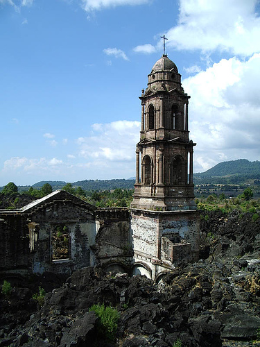
wiped off the map. Very close to it is now the crater of the
volcano. Of the second village, only part of the church is visible,
buried by the lava, as is the rest of the village, except for the
left tower in front (the right tower apparently fell but the truth
is that it was under construction at the time the phenomenon began)
as well as the apse, along with the altar.
This monogenetic
volcano, that is, it is born only once and has a short eruption that
can last from months to several years, marked a historical and
significant event in volcanology both in Mexico and worldwide. This
is because the volcano served as a study model for future eruptions
and allowed scientists to better understand volcanic processes.
The activity was concentrated around the cracks that formed in the
Cuiyusuru Valley. The most relevant of this period was the formation
of a premature cone followed by recurrent lava flows and the
intermittent eruption of bombs and lapilli.
At this stage,
the cone reached 200 and 365 meters in height in four and eight
months respectively.
The population of Paricutín was evicted
in June 1943, and that of Santa Ana Zirosto was relocated a few
months later.
On May 10, 1944, the inhabitants left San Juan
Parangaricutiro, embarking on a 33-kilometer walk, in which they
carried an image of the Lord of Miracles. On May 23, 1944 they
arrived at the exhacienda de los Conejos, 8 kilometers from Uruapan,
where they determined to establish the new town of Nuevo San Juan
Parangaricutiro, constituted as a municipality in 1950.
Despite its short duration, the main activity of lava spills from the volcano, oriented towards the north, took place during this period. Its emplacement was caused by the formation of a series of cracks and secondary ducts, of which the most important was undoubtedly the Sapichu ("child" or "young", in Purépecha).
It refers to the activity related to a series of cracks formed to
the south and east of the main cone, known to geologists of the time
as Taquí and Ahuan.
This period is also distinguished by
recording a reactivation of the main cone, which caused the main
lava spills, which reached the maximum distance to the west and
northwest of the main cone.
Until the end it maintained a
paroxysmal type activity, and the formation of the Los Hornitos mesa
(south of the cone) and the San Juan flows formed between April and
August 1944 are noteworthy. In fact, this last flow caused the
evacuation and the successive destruction of the town of San Juan
Parangaricutiro (with 1895 inhabitants).