Location: Summit County and Cuyahoga County, Ohio Map
Area: 32,947.07 acres (133.33 km2)
Fees and permits
Entry into
the park is free, but scheduled events, concerts and other
activities may be subject to a fee.
Cuyahoga Valley National Park is an American
national park that preserves and restores the rural landscape along
the Cuyahoga River between Akron and Cleveland in northeastern Ohio.
The 131.8 km² park is administered by the National Park Service,
but within its boundaries are areas managed independently as county
parks or as public or private enterprises. The Cuyahoga Valley was
originally designated a National Recreation Area in 1974, then
redesignated a national park 26 years later in 2000, and remains the
only national park to originate as a national recreation area.
Cuyahoga Valley is the only national park in the state of Ohio
and one of three in the Great Lakes basin, with Isle Royale National
Park on Lake Superior and Indiana Dunes National Park bordering Lake
Michigan. The Cuyahoga Valley also differs from other national parks
in the United States in that it is adjacent to two major urban areas
and includes a dense network of highways, small towns, four
Cleveland Metroparks preserves, eleven Summit Metro Parks, and
public parks. and private attractions.
The Inn at Brandywine Falls (see the
Sagamore Hills article) is located within the park boundaries.
Additional lodging options can be found in nearby towns and cities.
Shady Oaks Farm Bed and Breakfast, 241 W. Highland Rd (1/2 mile
from red lock, on the towpath), toll-free: +1-800-785-9769.
Check-in: 3PM, check-out: 11AM. Shady Oaks Farm is a federal period
building furnished in antiques, on a 25-acre horse farm, with
English gardens, views of horses grazing. They have stables for
people trail riding on the parks 86 miles of bridle trails. 150.00
and up.
Camping
The National Park Service offers one
primitive campground (no drive-in access):
Stanford House
Primitive Campsites, 6093 Stanford Rd (in Peninsula). Five primitive
campsites are available for distance hikers and bicyclists using the
Towpath Trail. Drive-up use is not permitted. There is a maximum of
two tents and six people per site. Water and chemical toilets are
available. Camping is by reservation only. Reservations must be made
at least three days in advance by contacting the Cuyahoga Valley
National Park Association Reservation Coordinator's Office at +1 330
657-2909, ext. 119, Monday to Friday, 9AM-4PM Walk-up campers can
reserve unoccupied sites by visiting the Trail Mix store between
10AM, and 5PM on weekends only. $15.00/day.
There are also
several State Park campgrounds are nearby:
Findlay Lake State
Park, 25381 State Route 58, Wellington, +1 440 647-4490, camping and
cottages
1 Portage Lakes State Park, 5031 Manchester Rd, ☎ +1 330
644-2220. Camping only Portage Lakes State Park.
Punderson State
Park, Newbury, +1 440 564-2279, camping, cottages and lodge
2
West Branch State Park, 5708 Esworthy Rd, ☎ +1 330 296-3239. A park
located in Ravenna, offers camping, boating, hunting, and fishing
West Branch State Park.
Backcountry
The backcountry in
this unusual National Park takes you into the surrounding cities and
towns.
Indigenous history
Currently, no Native American
tribes have federal recognition in Ohio; however, the ancient
inhabitants of the Cuyahoga Valley were Native Americans. The Wyandot,
Iroquois, Ottawas, Ojibwas, Munsees, Potawatomis, Miamis, Catawbas, and
Shawnees all lived in or passed through this area, but the Lenape
Nation, also known as the Lenape'wàk or Delaware Nation, is considered
"the grandparents" of many Native Nations. of the upper Ohio River
Valley. They had a democratic and egalitarian sociopolitical structure
where the leaders (sachem) consulted the elders who advocated the
expectations of the people before decisions were made. The Lenape were
active in long-standing trade networks. distance and were highly skilled
in the creation of goods and art such as pottery, stone weapons,
clothing, and baskets. Wars, coercive treaties, and legislative changes
in the 18th and 19th centuries led to the movement of the Lenapé both
west and west. south from its geographic origins in present-day New York
City, the lower Hudson Valley, eastern Pennsylvania, New Jersey, and
northern Delaware, through the Valley of the Ohio River and the Cuyahoga
Valley, to current residences primarily in Oklahoma and Ontario, Canada.
Indigenous land use
Our concept of land is that it is not a thing
to be owned, but something sacred and alive. We have a saying: "We do
not own the earth, we are of the earth, we belong to it." We call the
Earth Kukna, our mother. All life comes from the earth, it nourishes us,
it carries all life and it gives us a place to put our feet.
Hìtakonanu'laxk (Lenape Nation)
Land was of vital importance to
the Lenape nation. The fur trade required large hunting grounds, as did
agriculture, which served as the main source of food. Maize was a
staple, along with squash, beans (the three sisters), and augmented by
squash and sweet potatoes. The Lenape also foraged for fruits, wild
vegetables, nuts, and roots to supplement their crops. Many primary
accounts of the Lenape written by whites downplay their hunting skills
and highly efficient agricultural practices. These accounts falsely
emphasize men's labor (hunting) as the main source of food, when it was
largely sustained by through agriculture and was produced predominantly
by women. As the Lenape Nation was pushed west, the ecological coherence
between present-day Pennsylvania and Ohio allowed them to continue
similar farming, hunting, and fishing practices; however, as treaties
and violent conflict continued, the Lenapé were not allowed enough time
to develop a relationship with the land in the Ohio River Valley. As
they were pushed west, the Lenapé turned to each other. others to form
alliances among Lenape communities to preserve culture, territory, and
resources.
Lenape hunting practices changed with the introduction
of the fur trade. After contact with Europeans, the emphasis in hunting
began to shift toward the demands of fur production rather than
prioritizing sustainability. With this change in Lenapé hunting
practices, populations of beavers and other fur-bearing animals
plummeted. Additionally, this change is attributed to the loss of many
skills and technologies due to increased use of, and eventual reliance
on, European goods. These trade networks depended on the waterways used
by indigenous peoples during the 17th and 18th centuries:
Portage
Road was located in present-day Summit County, Ohio. The road connected
the Cuyahoga and Tuscarawas rivers and was approximately eight miles
long. American Indians used this road to transport their canoes overland
from one river to another. Using canoes, American Indians can travel by
water from the Great Lakes to the Gulf of Mexico, except for this small
section. Today, most of the trail is in the city of Akron, Ohio,
although those interested can follow the signs that trace the path
between the two rivers. Portage County was named after Portage Road.
The land of the Cuyahoga Valley was central to Lenape
religious practices, as they believed they were part of a spirit world
that existed in everything between earth and heaven. The spirits, or
manitu, lived in the natural world and provided advice to young Lenape
throughout their adulthood. Personal experiences with the manitou were
expressed in song, dance, and vision. These reunions between the person
and the spirit occurred most frequently in the Big House Ceremony/Rite,
or Gamwing The Gamwing was based on themes of gender, responsibility,
revelation (the link between the human and the spirit) and lasted twelve
days. During this time, the Wolf, Turtle and Turkey clans of the Lenape
came together as a community and renewed their ties to creation. The
Gamwing, its structure, and its cultural significance enabled the Lenapé
to continue to practice their religion and exist as a community even
through relocation and American expansion.
Treaties and conflict
The Cuyahoga Valley is no longer inhabited by the Lenape Nation
primarily due to coercive legislative processes and numerous violent
conflicts. In 1805, 200,000 hectares of land, including present-day
Cuyahoga Valley National Park, was ceded in the Fort Industry Treaty.
with the promise of an annual payment of $1,000 to each native nation
that lost land (the Wyandots, Ottawas, Ojibwas, Munsees, Lenapes,
Potawatomis, and Shawnees). The treaty also included a clause allowing
Indian hunting to continue in ceded land; however, that part of the
treaty was ignored in practice. Other treaties, including the Caminante
Purchase Treaty of 1739, the Easton Treaty of 1758, the Paxton Massacre
of 1763, the Greenville Treaty of 1795, and the Santa Maria Treaty of
1818, also took land from Lenapé without his full knowledge. or consent.
Today, the Lenape Nation is most commonly known as the Delaware Nation
and is based in Oklahoma, although there are also populations in Kansas,
Wisconsin, and Ontario, Canada, as well as their ancestral territories,
including Pennsylvania, 6 New Jersey, and Delaware.8
Later
history
The valley began providing recreation for city dwellers in
the 1870s, when people came from nearby towns for carriage rides or
canal boat tours. In 1880, the Valley Railway became another way to
escape urban industrial life. Actual park development began in the 1910s
and 1920s with the establishment of the Cleveland and Akron Metropolitan
Park Districts. In 1929, the estate of Cleveland businessman Hayward
Kendall donated 1.7 km² around Ritchie Ledges and a trust fund for the
state of Ohio. Kendall's will stipulated that "the property is to be
used perpetually for park purposes." The area was named Virginia Kendall
Park, after his mother. In the 1930s, the Civilian Conservation Corps
built much of the park's infrastructure, including the Happy Days Lodge
and the lodges at Octagon, Ledges, and Kendall Lake. Happy Days Lodge,
near Peninsula, was built between 1938 and 1939 as a camp for urban
children. The lodge is currently used only as a special events site.
Although regional parks safeguarded certain places, in the 1960s
local citizens feared that urban sprawl would overwhelm the natural
beauty of the Cuyahoga Valley. An additional concern was the
environmental degradation of the Cuyahoga River through factory waste
and sewage, along with the fires that burned in the river in 1952 and
1969. Citizens joined forces with state and national government
personnel to find a long-term solution. Finally, on December 27, 1974,
President Gerald Ford signed the bill establishing the Cuyahoga Valley
National Recreation Area into law, even as the administration
recommended a veto because "The Cuyahoga Valley has no qualities that
would qualify it for inclusion." in the National Park System" and the
government was already providing funding for outdoor recreation.
The National Park Service acquired the 0.2 km² Krejci
landfill in 1985 to include it as part of the recreation area. They
requested a thorough analysis of the site's content from the
Environmental Protection Agency. After the survey identified extremely
toxic materials, the area was closed in 1986 and designated a superfund
site under the Comprehensive Environmental Response, Compensation, and
Liability Act (CERCLA) of 1980. Litigation was brought against the
potentially responsible parties : Ford, GM, Chrysler, 3M, Waste
Management, Chevron, Kewanee Industries, and Federal Metals. Only 3M did
not agree to a settlement, and the company lost at trial. Removal of
toxic materials began in 1987 with 371,000 short tons (337,000,000 kg)
of contaminated soil and debris removed by 2012, with restoration
completed by 2015. The area was redesignated a national park by Congress
on October 11, 2000, with passage of the Department of the Interior and
Related Agencies Appropriations Act of 2001, House Bill 4578, 106th
Congress. The park is administered by the National Park Service. The
David Berger National Monument in Beachwood, a suburb of Cleveland, is
also administered through the Cuyahoga Valley National Park.
The
Coliseum at Richfield, a multi-use arena in the Cuyahoga River area, was
razed in 1999 and the vacant site became part of Cuyahoga Valley
National Park upon its designation in 2000. The area has since become a
grassy meadow that is a popular site for bird watching.
Animals found in the park include raccoons, muskrats, coyotes, skunks, red foxes, beavers, peregrine falcons, river otters, bald eagles, opossums, three species of moles, white-tailed deer, Canada geese, foxes grays, minks, great blue herons and seven species of bats.
According to the Köppen climate classification system, the Boston Mill Visitor Center in Cuyahoga Valley National Park has a hot-summer temperate continental climate (Köppen climate classification Dfa). The plant hardiness zone at the Boston Store Visitor Center is 6a with an average annual extreme minimum air temperature of −6.5 °F (−21.4 °C).
The Cuyahoga Valley features natural, man-made, and
private attractions, which is unusual for an American national park. The
park includes compatible use sites not owned by the federal government,
such as the regional parks of the Cleveland Metroparks and Summit Metro
Parks systems.
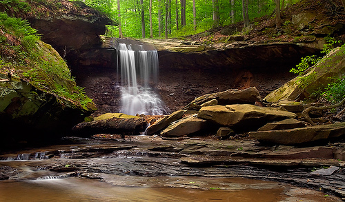
Natural areas include forests, hills, narrow
ravines, wetlands, rivers, and waterfalls. Nearly 100 waterfalls are
located in the Cuyahoga Valley, with the most popular being the 20 m
high Brandywine Falls, the highest waterfall in the park and the highest
in Northeast Ohio. The Ledges is a rocky outcrop that offers a view to
the west across the wooded areas of the valley. The Talus caves are
found among the rocks in the forest around the ledges.
The park
has many trails, notably the 20-mile Towpath Trail, which follows an
earlier 300-mile stretch of the Ohio and Erie Canal and is popular for
hiking, biking, and running. Skiing and sledding are available during
the winter in Kendall Hills. Visitors can play golf or take scenic hikes
and train tours on the Cuyahoga Valley Scenic Railroad during special
events.
The park also features preserved and restored exhibits of
19th and early 20th century sustainable agriculture and rural life, most
notably Hale Farm and Village, while also catering to contemporary
cultural interests with art exhibits, outdoor concerts, and theatrical
performances at places like Blossom Music. Center and the Porthouse
Theater at Kent State University. In the mid-1980s, the park hosted the
National Folk Festival.
The multifunctional Ohio and Erie Canal Towpath Trail
was developed by the National Park Service and is the primary trail
through Cuyahoga Valley National Park. The trail runs nearly 21 miles
from Rockside Road in Independence in the north to the Summit County
Bike & Hike Trail in the south, following the Cuyahoga River for much of
its length. Restrooms are available at several trailheads, and food and
drink outlets are along Rockside Road, as well as the Boston store on
Peninsula, and the seasonal farmers' market on Botzum Road. Three
visitor centers are located along the way: the Canal Exploration Center,
the Boston Store, and the Hunt House. The trail connects to a Cleveland
Metroparks trail at Rockside Road, which continues another 6 miles
north. The Summit County Trail continues through Akron and further south
through Stark and Tuscarawas counties to Zoar, Ohio, nearly 110 km
continuously, with a single 1.6 km interruption. Sections of the towpath
trail outside Cuyahoga Valley National Park are owned and maintained by
various state and local agencies. The trail also meets the Buckeye Trail
in the national park near the Boston Store. Another section of the
Summit County Bike and Hike Trail System is nearby, connecting to
Brandywine Falls, the Cleveland Metroparks Bedford Reservation and the
cities of Solon in Cuyahoga County, Hudson and Stow in Summit County,
and Kent and Ravenna in Portage County.
Seasonally, the Cuyahoga
Valley Scenic Railroad (CVSR) allows visitors to travel the towpath from
Rockside Road to Akron, embarking or disembarking at any of the stops
along the way. The train is especially popular with cyclists and for
viewing and photographing the fall colors. CVSR is independently owned
and operated.
The Towpath Trail follows the historic route of the
Ohio and Erie Canal. Before the canal was built, Ohio was a sparsely
populated desert where travel was difficult and getting crops to market
nearly impossible. The canal, built between 1825 and 1832, provided a
new transportation route from Cleveland on Lake Erie to Portsmouth on
the Ohio River. The canal connected Ohio to the rest of the eastern
United States. Numerous exhibits along the way provide information about
the canal's features and sites of historical interest.
Visitors
can walk or ride along the same path used by mules to tow canal boats
laden with merchandise and passengers. The scene is different from then;
the canal was full of water carrying a constant stream of boats.
Evidence of beavers can be seen in many places along the trail.
Stanford House (formerly Stanford Hostel)
Located in the picturesque
Cuyahoga Valley near the Peninsula, Stanford House is a historic
19th-century farmhouse built in the 1830s by George Stanford, one of the
first settlers on the Western Reservation. In 1978, the NPS purchased
the property to serve as a youth hostel in conjunction with the American
Youth Hostels (AYH) organization. In March 2011, Stanford Hostel became
Stanford House, the first in-park lodging facility in Cuyahoga Valley
National Park. The house was renovated by the Conservancy for the
Cuyahoga Valley National Park and the National Park Service.
trail headers
Within the national park, trailhead parking for the
towpath is available along Canal Road, north to south, at:
Block 39:
West of the intersection with Rockside Road; 41.39309, -81.628565
Canal Exploration Center, on Hillside Road; 41°22′21″N 81°36′47″W
Frazee House: South of Alexander Road, North of Sagamore Road;
41.352443, -81.592377
and along Riverview Road, from north to
south, at:
Station Road Bridge: east along with Chippewa Creek
Drive; 41.318618, -81.587957
Red Lock: east of the river, along
Vaughn/Highland Road; 41.289148, -81.563379
Boston Store: east on
Boston Mills Road; 41.263205, -81.559408
Peninsula Depot – East
across the river on Route 303, then N Locust Street and W Mill Street to
parking lot; 41.243331, -81.549186
Lock 28: also called Deep Lock;
south of Major Road;
41.229917, -81.554756
Hunt House: on
Bolanz Road; 41.200288, -81.57201
Ira Road – Just north of the
intersection; 41.184467, -81.583038
Botzum Station: south of Bath
Road; 41.158453, -81.573788.
The Cuyahoga River's "V" course is quite unusual,
first flowing southwest and then turning sharply north to empty into
Lake Erie not far from its source. The left arm of this "V", which flows
north through the park, corresponds to an older pre-glacial valley,
while the right arm corresponds to a relatively new drainage. The new
segment cut into the old one at Cuyahoga Falls, the base of the "V".
Other streams have made routes into the preglacial Cuyahoga Valley
cutting gorges with waterfalls like those found along Tinkers,
Brandywine, and Chippewa creeks. These waterfalls are formed when
flowing water erodes the Bedford Shale, which underlies the more
resistant Berea Sandstone. Glacial drift fills the valley to a depth of
120 m. This landfill is very complex due to the waterlogging in front of
the ice before and after each glaciation. Beach deposits, gravel bars,
and other shoreline deposits from Lake Maumee are found in the valley,
as are gravels from the Lake Arkona era and ridges that mark the shores
of Lake Whittlesey, Lake Warren, and Lake Wayne.
A notable
remnant of the Wisconsin glaciation is the Defiance moraine, which
extends from Defiance in western Ohio, across the state to Pennsylvania.
As Cushing et al. note, "The Defiance moraine represents the last
notable support of the glacial front in this region." The moraine ranges
in width from 3.2 to 6.4 km and, according to Leverett, "is like a broad
wave whose crest rises 20 to 50 feet above the edge of the outer plain."
This moraine forms a lobe that juts south into the valley for 13 km to
the Peninsula, the lobe being 9.7 km wide at the northern end, tapering
to 4.8 km wide at the northern end. south end. Kames and eskers mark the
terrain south of this moraine to the southern extent of the glaciation.
Berea Sandstone and Bedford Shale were deposited in a river delta
setting in the Mississippian. The river channels were incised into the
Bedford Shale and these channels were later filled in with Berea
Sandstone. As well as setting the stage for majestic gorges and
waterfalls within the valley, they have also provided economic use.
Berea sandstone was mined in Berea for grinding stones and building
stones, while the lower Bedford Shale was mined in South Euclid and
Cleveland Heights for its bluestone.
The Sharon Conglomerate is a
Pennsylvanian formation composed of sandstone and conglomerate that
forms, according to Cushing et al., "Disconnected patches or outliers
covering the higher foothills...these outliers stand out boldly from the
surrounding country" because to its resistance to erosion. The Boston
Ledges are the most notable example. As the Mississippian shale below is
washed away, huge Sharon blocks result from settlement. As Cushing et
al. They explain, "the action of the frost helps to separate these
blocks, the cracks widen to form caves and a tangle of blocks results,
separated by passages of unequal widths."
Shale gas has been
produced in the area since 1883, when H.A. The Mastick well was drilled
in Rockport Township to a depth of 161m, returning 612.9m³) of gas per
day. A gas boom ensued in 1914-15, and by 1931 several hundred gas wells
were producing from the Devonian Huron shale. Production came from
shales 380 m thick at depths of 120 to 560 m. Pressures ranged from 3 to
135 psi) and flowed less than 570 m³ of gas a day, but it was enough to
provide light for a house or two, and sometimes heating. As Cushing et
al. noted in the 1930s, "there are large quantities of oil in the
Devonian shales." Since then, the Marcellus Shale and the deeper Utica
Shale have demonstrated their economic potential.
The Canal Exploration Center is located along Canal
Road at Hillside Road in Valley View, south of Rockside Road. The
visitor center contains interactive maps and games related to the
history of the canal, especially the years from 1825 to 1876. The
canal-era building once served passengers from canal boats waiting to
pass through the lock 38 of the Ohio and Erie Canal.
Boston Store
was built in 1836 and is located to the east of Riverview Road. The
building was used as a warehouse, store, post office, and general
meeting place. The visitor center has a museum with exhibits on canal
boat building. A short video is available, as well as maps, brochures,
and NPS passport stamps.
The hunting house at Riverview and
Bolanz Roads is typical of late 19th century family farms in the
Cuyahoga Valley. Visitors can learn about park activities and view
exhibits on the area's agricultural history. The estate is an ideal
starting point for a walk or bike ride, as it sits alongside the canal's
Towpath Trail.
The Frazee House on Canal Road in Valley View
south of Rockside Road was built between 1825 and 1826, during the same
years that the northern section of the canal was excavated. The house is
a fine example of a Western Reserve home and features exhibits relating
to architectural styles, building techniques, and the Frazee Family.
Channel Exploration Center
Exhibits related to the
history of the Ohio and Erie Canal are available at the Canal
Exploration Center. The exhibits are housed in a renovated canal-era
tavern that had such a colorful reputation it was dubbed "Hell's Half
Acre." The lock 38 is located at the front.
Structures related to
the Ohio and Erie Canal
The Ohio and Erie Canal was built between
1825 and 1832, providing Ohio with a transportation system that allowed
residents to trade with the world. While it ceased to function after the
Great Flood of 1913, remnants and ruins of canal-related structures can
be seen along the Towpath Trail of the Ohio and Erie Canal. Roadside
exhibits explain the function of many of the structures visible from the
trail.
Hale Farm and Village
Hale Farm and Village is an
open-air living history museum. Costumed interpreters describe life on
the Western Reserve. The town has 21 historic buildings and many
talented artisans. The site is operated by the Western Reserve
Historical Society. Craft demonstrations include glass blowing, candle
making, brooming, spinning and weaving, cheese making, blacksmithing,
carpentry, sawmilling, home cooking, and pottery making. The farm also
has oxen, sheep, cows and orchards.
Frazee House
The Frazee
House was under construction in 1825 when the canal was dug in its front
yard. The house was built in the Western Reserve style of architecture.
Boston Store (Boston Mill Visitor Center)
This canal-era building
was owned by the Boston Land and Manufacturing Company. The store has
numerous displays of canal boat building.
Peninsula Depot
The
Cuyahoga Valley Scenic Railroad (CVSR) Peninsula Depot is located on
West Mill Street in the town of Peninsula. The depot was originally in
the town of Boston, but moved to the Peninsula in the late 1960s. The
building may be the only surviving combined station of the Valley
Railway, which operated between Cleveland and Tuscarawas County in the
late 19th century . The depot is an operating station for CVSR train
travel.
stanford house
James Stanford moved to Boston Township
immediately after surveying and naming it in 1806. He, his wife Polly,
and his son George were the first settlers in what is now Cuyahoga
Valley National Park. His son George built the stately Greek Revival
home around 1830. The home accommodates meetings and retreats as a
day-use facility, and tourists as a moderately-priced overnight facility
with nine bedrooms. The house had previously served as a youth hostel.
Everett Covered Bridge
The Everett Covered Bridge, the only
covered bridge in Summit County, was built after a local resident was
killed trying to cross swollen Furnace Run in 1877. The bridge was
destroyed by storm flooding in 1975 and rebuilt by the National Park
Service in 1986. The bridge is located on Everett Road approximately
half a mile west of Riverview Road near Everett Village.
Brandywine Village
Brandywine Village was conceived and founded by
George Wallace, who built a sawmill next to Brandywine Falls in 1814. He
encouraged others to move to the area, including his brother-in-law, who
built a mill on the opposite side of the falls. . With cheap land
available and the presence of mills to provide lumber, flour, and
cornmeal, Brandywine Village began to grow. A couple of buildings remain
from the village, and you can also see historical photos and remains of
building foundations.
Structures of the Civil Conservation Corps
The Civilian Conservation Corps was responsible for the construction of
several structures in the valley. Happy Days Lodge and the lodges at
Ledges, Octagon, and Kendall Lake were built of American chestnut in the
late 1930s. All four structures are located in the Virginia Kendall Unit
of the park.