Location: Wisconsin Map
Length: 430 miles (692 km)
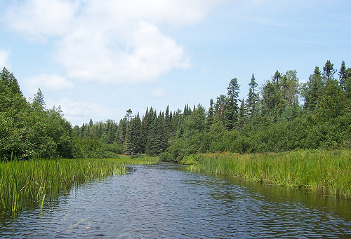
Wisconsin River is the longest river in the state
of Wisconsin in the United States. Its total length is measured at
430 miles (692 km). Pristine majestic shores of Wisconsin River
invite thousands of people for fishing, kayaking, rafting and other
activities.
The name of the river was mentioned for the
first time in 1673 by the French explorer Jacques Marquette as
"Meskousing" It is based on the Algonquian languages used in the
region by Indian tribes, but its original meaning is not known. The
French explorers who later followed the path of Marquette changed
the name to "Ouisconsin". The name was simplified at the beginning
of the 19th century as "Wisconsin", before being applied to the
Territory of Wisconsin and, finally, to the same state of Wisconsin.
The first documentary news of the exploration of the Wisconsin
River by Europeans dates from 1673, when the French Jacques
Marquette (1637-1675) and Louis Jolliet (born in Canada, 1645-1700),
traveling by canoe from Lake Michigan upstream to The Fox River,
arrived at the present site of Portage at the beginning of June. In
this place the Wisconsin and Fox rivers are only about 3.2 km away,
so the explorers could make the portage of the Fox River to the
Wisconsin River. Then they followed the 320 km to the mouth of the
Wisconsin and reached the Mississippi River on June 17. Other
explorers and traders followed the same path and for the next 150
years, the Wisconsin and Fox Rivers, collectively known as the
Fox-Wisconsin Waterway, formed an important transportation route
between the Great Lakes and the river Mississippi.
The
industry began to form in Wisconsin at the beginning of the 19th
century, when loggers began to use the log ponds downstream from the
northern forests to the sawmills of the new cities such as Wausau.
In the 1880s, logging companies dammed the river to ensure it had
enough capacity for the logs to float downstream. Later, at the
beginning of the 20th century, more dams were built to provide for
the control of floods and hydroelectric power. The dams also boosted
tourism, creating dams such as Lake Wisconsin, popular areas for
recreational navigation and fishing. Today, the Wisconsin River is
impounded in 26 places.
Despite this, about 150 km of the
stretch between the mouth and the hydroelectric dam in Prairie du
Sac are free of any dam or barrier and the waters flow with relative
fluidity. In the late 1980s, this part of the river was designated
as a "state waterway", and development along the river has been
limited to preserve its landscape integrity. The Lower Wisconin
Riverway Project is a state-funded project designed to protect that
stretch. The Wisconsin Department of Natural Resources manages more
than 75,000 acres of protected land, including the river itself,
islands, and some nearby land.
This long stretch of free
river provides important natural habitats for a wide variety of
wildlife, including white-tailed deer, otter, beaver, turtle, sand
cranes, eagles, hawks, and a wide variety of fish species.
The Lower Wisconsin River State Riverway is a state-funded project
designed to protect the southern portion of the Wisconsin River. It
extends 93 miles (150 km) from Sauk City to the point where the
Wisconsin River empties into the Mississippi, about 3 miles (4.8 km)
south of the city of Prairie du Chien. The Wisconsin Department of
Natural Resources manages protected lands of over 75,000 acres (300
km2), including the river itself, islands, and some lands adjacent
to the river.
Recreational opportunities on the lower
Wisconsin River range from fishing and canoeing to tubing and
camping. Canoe camping is particularly popular because of the
abundance of suitable sandbars along the riverway and because no
permits are required. On summer weekends, naturists can be found on
Mazo Beach which is north of the village of Mazomanie. According to
the Wisconsin Department of Natural Resources, two thirds of river
users can be found on the stretch between Prairie du Sac and Spring
Green.
The name of the river was first recorded in 1673 by Jacques Marquette as Meskousing, derived from the Algonquian languages of the local Indian tribes, the original meaning of the word is not exactly known. French explorers who followed Marquette changed the name to Ouisconsin, which is how the river was called on the map of Guillaume Delisle (Paris, 1718). At the beginning of the 19th century, the name was simplified to the current Wisconsin, and the territory of Wisconsin, and later the state of Wisconsin, received this name.
The river originates in the forests of Lake District
in northern Wisconsin, from Lac Vieux Desert Lake near the border with
Michigan. It flows south through the glacial plains in the center of the
state. In the southern part of the state, the river collided with
terminal moraines formed during the last ice age, which created a gorge
along the channel with a length of about 8 km. North of Madison, near
Portage, the channel turns west, flows through the rolling Western
Uplands, and enters the Mississippi about five kilometers south of
Prairie do Chin.
The river divides the state into Western and
Eastern parts.
Ferry
There is a ferry service on the river
from the city of Merrimack.