Location: 30 Ramey Dr, Collinsville Map
Tel (618) 346 5160
Open: 8am- sunset daily
Visitor Center: 9am- 5pm
Closed: public holidays
Official site
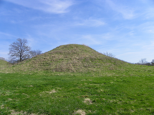
The main features of the site are the
70 remaining man-made mounds, the largest of which is Monks Mound,
around 100 ft (30 m) tall. The rest of the 2,200-acre (890-hectare)
site consists of many grass covered mounds that vary in size and
shape, several interpretive trails and signage, a reconstruction of
the Woodhenge sun calendar, and reconstructions of the
palisade/stockade walls.
Cahokia Mounds State Historic Site,
30 Ramey Street, Collinsville, ☎ +1 618 346-5160, e-mail:
cahokia.mounds@sbcglobal.net
Cahokia Mounds State Historic Site is a massive settlement of Native Americans in Collinsville in the South Illinois in USA. Cahokia Mounds State Historic Site is the largest archaeological site North of Mexico. Cachokia is an Amerindian archaeological site located near Collinsville (Illinois), on the Mississippi River Plain in the southwest of that state, near the city of St. Louis (Missouri). It is formed by a series of mounds or artificial earth mounds. Cachokia is the largest site related to the Mississippian culture, which developed an advanced society in eastern North America before the arrival of Europeans. It is estimated that Cachokia was founded four centuries before the arrival of Christopher Columbus in America.
The region in which Cachokia is located was the
territory of nomadic people who lived by foraging. The way in which
Cachokia emerged and disappeared is a matter of discussion among
specialists. According to some of them, the city could have been
born of a collective consensus or, on the initiative of a very
powerful small group. The period of flowering of Cachokia and other
Mississippian cities corresponds to the X-XIII centuries of the
Christian era. During that time the mounds of Cachokia were built,
which are large agglomerations of land that was extracted from the
vicinity of the city.
The situation in which the decline of
Cachokia occurred is unclear. In general, hypotheses have been
proposed that are not supported by strong evidence. Some researchers
believe that the Mississippi Valley was subjected to a long drought
that caused lower crop yields. Others propose that the city was
involved in a series of external or internal political conflicts.
Perhaps the end happened after a large flood of the Mississippi
River that struck the base of the pyramid, taking ahead of all those
who had not yet marched or fled by the increasing famine by
successive droughts, or internal revolts for lack of hand of work
that worked the earth.
The inhabitants did not leave written
records, and the original name of the place is not known. "Cachokia"
is the name of a tribe of illiniwek that lived in the region when
the first French explorers arrived, in the seventeenth century, long
after the abandonment of Cachokia. It is not known with certainty
what current native groups may be the descendants of the Cachokia
settlers, but the Osage consider themselves descendants of the
Caahokians.
Entrance to the site is free, though a donation of $7 for adults, $4 for children, and $15 for families is suggested.
Every day
Public Tours. During June, July, and
August public one hour tours are conducted Wednesday through
Saturday at 10:30AM and 2:30PM, and Sunday at 12:30PM and 2:30PM.
The tour goes through the Grand Plaza to the Twin Mounds and Mound
72. During April, May, September, and October public tours are
conducted on Saturdays and Sundays at 2:30PM. No public outdoor
tours Nov-Mar. No reservations are needed. Depending on the guide
and the weather, some tours may go up Monks Mound. Free.
iPod
audio-visual tours and other Self-Guided Tours. Available year round
during operating hours. iPods are available for rental in the Museum
Shop. These are loaded with three outside tour trails (Grand Plaza,
Monks Mound, Woodhenge) and a tour through the exhibit gallery in
the Interpretive Center. Adult and child versions of each tour are
included on the iPod. Available in English, German, and Spanish. As
an alternative, visitors can also obtain a free cassette player at
the Information Desk for an audio tour of the three outside tour
trails, or purchase a written version Guidebook for $1 in the Gift
Shop (available in 12 languages). $3 (Groupon deals sometimes
available).
Walk the site. In any season of the year, and every
day of the week, the grounds of the site are open to walk from 8AM
to dusk. See above options for self-guided tours during operating
hours. Interpretive signs can be found along the trails and on days
the Interpretive Center is closed, there is a box of brochures and
trail maps outside the front door.
Geocaching. Geocaching is a
sort of scavenger hunt using a GPS receiver to locate the hidden
item. Several geocaches in the park have been created with official
permission.
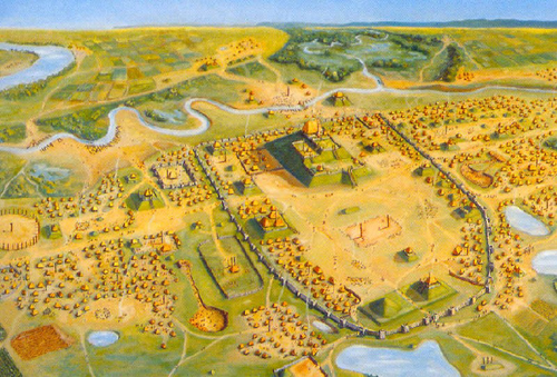
The mounds covered an area of 15 square kilometers. At the center of
the city was an 81-hectare area surrounded by a 2-mile-long,
12-foot-high wall of wooden blocks, enclosing 17 mounds. At its center
was the largest of the Monks Mound, a 30.6 meter high, flat-topped earth
pyramid that covered a base area of 291 by 236 meters, i.e. over five
hectares. Around this protected central area lived thousands of people
in groups centered on ceremonial poles.
The truncated pyramid,
named Monks Mound for a nearby Trappist monastery, is the largest
pre-Columbian man-made structure north of Mexico. It is estimated that
14 million baskets of earth had to be moved in order to gradually build
up the mound, which has a volume of 692,000 cubic meters. Four levels
were created over 200 years, each of which was interspersed with
channels to drain rainwater. On top of the mound stood a wooden building
measuring 31 by 14 meters in area and 15 meters high. In 1998, a layer
of sandstone was discovered about twelve meters below the surface of the
mound. These large quantities of sandstone cannot have come from the
region, so they must have been transported over long distances.
The planning of the city represented an attempt to reflect the order of
the world, with a northern part as Father Sky and a southern part as
Mother Earth. These were separated by a west-east running road. Another
main road ran northeast. Their crossing was at the central plaza, the
main square with the largest mound. At the outer ends of the streets
were four circles of logs (red cedar), arranged apparently for
astronomical purposes.
A man in his 40s who died around 1050 was
found under Mound 72. He was buried under 20,000 shells and 800 unused
arrows. Four men were found with him, whose hands and heads had been
severed, as well as 53 strangled women, aged between 15 and 25. A total
of 280 skeletons have been dug up so far, 50 of them alone in a deep
well - many of them were obviously injured before they died. These are
probably human sacrifices as known from the Aztecs.
The excavations, which began in advance of road planning, have shown that astronomy was a concern. Archaeologists therefore spoke of "Woodhenge" because, analogous to the English Stonehenge, wooden posts were used to determine the spring and autumn equinoxes, thus developing a kind of calendar. In a farming society, determining the seasons and the dates of sowing and harvesting are of paramount importance.
The city may have controlled a flint, copper, and shell trade as far north as Minnesota. Cahokia's trade extended to Kansas to the west and Tennessee to the east. Raw materials came to the city and were refined there. These products, in turn, reappeared in a wide area, so that one assumes a trading network.
It is unclear why the inner city, possibly the residence of the
leading groups, was surrounded by a large wall in the 11th century,
which was secured by a watchtower every 70 m. Apparently this happened
in a great hurry, because it also cut through inhabited areas. The
growth of the places in the more distant surroundings around 1200 is
detectable, which may have prompted Cahokia to build the larger wall. In
any case, the inner wall was renewed three more times by 1300.
The archaeologist Timothy Pauketat put forward the thesis that Cahokia
grew explosively within a few decades in the 11th century, so that a
larger settlement with perhaps 1,000 inhabitants suddenly became a city
with well over 10,000. In fact, there is evidence in local lore that the
peasants in the region's scattered settlements left their villages to
live in Cahokia at the initiative of a great chief. The chiefs were thus
considered the brothers of the sun and it is believed that they
originally oversaw the flood plains, which were annually supplied with
fertile mud by the floods, and organized the necessary works.
After 1200 Cahokia began to decline. The reasons for this are
unclear. Ecological reasons were often given in connection with the
excessive demands placed on the surrounding area by the cultivation of
maize, which could have led to severe deforestation. It turns out that
softwood had to be increasingly used for construction, perhaps because
the hardwood stocks had been cut down. Overpopulation was also
considered. A civil war could also have been the cause, or the
destruction of one of the large mounds by a mudslide.
Ultimately,
it is not known why the city was finally abandoned around 1400. The
population declined significantly, Cahokia became meaningless,
eventually abandoned.
Discovery and Endangerment
When
Europeans first came to the area, they believed the mounds to be natural
phenomena, and the great mound was first described in 1810. To this day,
agriculture, industrial waste and emissions, and road construction pose
less of a threat to the central site than to the surrounding smaller
settlements.
Since the 1960s, excavation campaigns have made the importance of the city ever clearer. A UNESCO World Heritage Site since 1982, the Cahokia Mounds State Historic Site has its own museum, is located on 890 acres of parkland managed by the Illinois Historic Preservation Agency, and is open to the public. The connection with today's Indians is unclear, but the city seems to enjoy a certain reverence (again).