Location: Mount Desert Island Map
Hulls Cove Visitor Center
Tel. (207) 288 3338
Open: mid- Apr- Oct- daily
Area: 41,000 acres
Blackwoods Campground
800-365-2267
$20 (May 1-October
31), $10 (April and November), free (December 1-March 31)
Duck Harbor Campground
Isle au Haut
Open: May 15- Oct 15
Seawall Campground
Tel. 207-288-3338
Fee: $14 walk-in, $20
drive-in
Acadia National Park covers much of Mount Desert Island in a state
of Main along many minor islands of the coast. It covers an area of
41000 acres. Despite its small size Acadia National Park has an
expansive network of trails that are 120 mi long in total.
Additionally, it has three campgrounds for tourists who want to
spend more time here. Their telephones and additional information is
stated on the left.
The area around Acadia National Park was
originally inhabited by Wabanaki native tribes. In 1604 it was first
visited by famous explorer Samuel de Champlain. In 1919 it got a
status of a national park. Initially Acadia National Park was known
as a Lafayette National Park.
Precipice Trail (Acadia National Park)
Duration: 2.5- 4 hours
Distance: 1.6 mi (2.6 km)
Difficulty: medium – hard
The
Precipice Trail starts from parking zone of the Park Loop Rd. You
have to jump from boulder to boulder in the early portion of the
trail. First portion of the trail has a moderate ascent. After 0.4
miles trail reaches a junction with the Eat Face Trail that can take
a hiker to the Bear Brook Trail. The latter is more gradual approach
to the mountain. If you decide to follow with the Precipice Trail
you have to prepare for sharp drops, climbing ladders and iron rungs
and railings. This part of the trail is not really for those who are
afraid of heights and it needs more of mental gumption than physical
qualities. Last 500 feet of the trail level off with beautiful views
of Frenchman Bay, Great Head, Sand Beach and Atlantic ocean.
Bear Brook Trail (Acadia National Park)
Duration: 2 hours
Distance: 2 mi (3.2 km)
Difficulty: easy- medium
The trail
begins at Park Loop Rd, east of Bear Brook picnic area. At half a
mile it intercepts with Champlain East Face Trail that leads to
Precipice Trail. Due to glaciers in the area north- south slopes of
the mountains are less steep than east- west thus this provides
hikers with alternative easier route to the mountain.
Cadillac Mountain (Acadia National Park)
Duration: 4-5 hours
Distance: 7 mi (11.3 km)
The trail starts at Blackwood
campground. This trail is popular with the tourists and thus you are
more likely to meet plenty of foot traffic. Once the path emerges
above tree line it comes across “The feather bed” a small pond. Once
you reach Cadillac mountain you will follow the Dorr Mountain Notch
Trail. You will arrive at a junction of Gorge Path and Murray Young
Trail. The Gorge Path will take you through a deep gorge with
granite walls reaching 30- 40 feet. Even in hot summers it is cool
and wet here. Be careful of the slippery rocks and walk with
caution. Eventually you will reach Sieur de Monts Spring and Abbe
Museum.
Dorr Mountain Summit (Acadia National Park)
Duration: 30 minutes
Distance: 0.8 mi (1.3 km)
This
alternative trail can be a pleasant diversion from a trail described
above. After reaching Cadillac Mountain follow the Dorr Mountain
Notch Trail. Once you will pass junction with Gorge Path and Murray
Young Trail you will have 0.8 miles to walk. Top of the Dorr
Mountain offers beautiful views of the island and Atlantic Ocean.
Before the creation of the park
Archaeological evidence shows that
Mount Desert Island has been inhabited for 6,000 years. In historical
times, the Wabanaki Indians lived here, engaged in hunting and fishing.
Their first contact with Europeans occurred on September 5, 1604, when a
French expedition landed on the island under the command of Samuel de
Champlain, later the founder of the first settlements in French Canada.
From 1613, the island was in no man's land between French Canada and
English Massachusetts, and for 150 years it was used only as a
navigational landmark. In 1688, the Frenchman Antoine Lome (also known
as de Lamothe-Cadillac) received a lease of land from the government
along the coast of Maine, including the entire island of Mount Desert,
but soon abandoned the idea of building a feudal state there. He later
became the founder of Detroit.
In 1759, British troops finally
destroyed the French presence on the coast of Maine, and the entire
coast was open to settlement. Massachusetts Governor Francis Bernard
received Mount Desert Island in concession from the British Monarchy and
in 1760 offered the land for free distribution to settlers. The first
two families to permanently settle on the island were those of Abraham
Soames and James Richardson. After the Revolutionary War, Bernard lost
his rights to the island, and the new US government transferred the
western part of Mount Desert Island to his son, John Bernard, and the
eastern part to Marie Therese de Gregoire, Cadillac's granddaughter.
Both owners quickly sold their lands. In the 19th century, the flow of
immigrants to the island increased. The main occupations of the
inhabitants were agriculture and fishing. In the middle of the century,
the island became popular with artists, especially landscape painters of
the Hudson school, including Thomas Cole and Frederick Church, who
appreciated the natural beauty of the island. By the 1880s, the island
was turning into a popular vacation spot for the townspeople, many farms
were sold and turned into summer cottages. In 1880, there were 30 hotels
operating on the island, and tourism was the main source of income. The
families of the Rockefellers, Morgans, Vanderbilts, Fords, and Carnegies
spent their summers on the island. This situation ended only with the
Great Depression, and in 1947 a fire destroyed most of the villas.
Since the beginning of the 20th century, supporters of the
conservation of land and turning them into a conservation area, led by
Charles Dorr, organized the Hancock County Trustees of Public
Reservations. By 1913, the society had bought 6,000 acres (about 25 km²)
of land and offered to turn it over to the federal government.
After the creation of the park
The park was created by President
Woodrow Wilson on July 8, 1916 as the Sieur Demont National Monument.
Charles Dorr became the park's first superintendent. From its inception
to the present, the park has been administered by the US National Park
Service. On February 26, 1919, the national monument was transformed
into Lafayette National Park (in honor of the Marquis de Lafayette, a
participant in the American Revolutionary War). The park was given its
present name, Acadia National Park, on January 19, 1929.
From
1915 to 1933, with the money of John Rockefeller, a network of gravel
roads with a total length of about 50 km, including 17 granite bridges,
was designed and built on Mount Desert Island. Almost all of this
network is still in use today.
On October 17, 1947, a
catastrophic fire occurred, as a result of which 40 km² of forest burned
out. The fire was one of many that broke out in Maine during the dry
summer of 1947. The fire was extinguished for several days; involved
forces from the Coast Guard, Navy, Army, local residents, and National
Park Service officers assembled from across the country. A significant
part of the funds spent on the restoration of the park was donated by
the Rockefeller family.
Acadia National Park is a typical part of the Maine coastline,
resulting from the destruction of the mountain range along the modern
coast by a glacier, as a result of which the Gulf of Maine was melted.
The result of the activity of the glacier is Soames Sound Fjord, the
only fjord on the Atlantic coast of the United States.
The tidal
strip is from three to four meters. Most of the coast is rocky, but
there are rocky and even sandy beaches.
Earthquakes occasionally
occur in the park, but they are relatively rare. From 1747 to 1992 there
were only 507 earthquakes. So, on October 2, 2006, an earthquake of
magnitude 4.2 occurred in the park. The epicenter was located in the
Atlantic Ocean. Some trails and roads were blocked with stones and
temporarily closed.
The park's climate is more temperate than other parts of northern New
England. 135 cm of precipitation is evenly distributed throughout the
year. The temperature can vary from -20 degrees in winter to +30 degrees
in summer. Snow falls in winter, but often melts when warmer. Snowstorms
are frequent in winter and early spring, and it rains almost every
month. Fog often falls in the park, most likely in June. In late autumn
and winter, strong winds occur, turning into storms. Hurricanes
occasionally pass through the region.
In the national park, from
November 1 to April 15 is officially considered the winter season, when
most of the tourist roads and other infrastructure are closed.
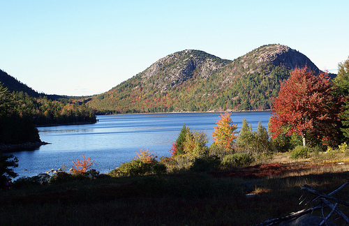
Despite its small area, Acadia National Park contains several different types of natural landscapes: mountains, lakes and ponds, forests, coasts and beaches, swamps and other areas that are periodically flooded with water.
The entire center of the island is occupied by mountains, of which
Mount Cadillac (466 m) is the highest. It is not the easternmost point
in the US, but due to the height of the mountain, it receives the first
rays of the sun in autumn and winter before any other points in the US.
All mountains are of tectonic and volcanic origin, later leveled by a
glacier. The mountains on Mount Desert Island are covered with spruce
and pine forests. To the top of Mount Cadillac, the only one of all,
there is a road that is closed in the winter season.
Mount
Cadillac (former Green) - height 466 m;
Sargent - 418;
Dorr
(former Flying Scadron) - 387;
Pimitik - 380;
Pinobscot (formerly
Jordan) - 364;
Bernard - 326;
Champlain (formerly Newport) - 322;
Gilmour - 316;
Bold - 297;
Mansell - 289;
Cedar Swamp - 287;
Parkman (formerly Little Brown) - 287;
North Bubble - 266;
Norumbega (formerly Brown) - 260;
Beach - 256;
South Bubble - 233;
Yugeno Head - 223;
McFarland - 221;
Triads - 212;
Acadia
(formerly Robinson) - 208;
Youngs - 207;
Saint Saveur (former Dog)
- 207;
Day - 177;
Gorham - 160;
Behive - 158;
Flying - 87.
The park is located in the transition zone between northern coniferous and southern broadleaf forests. Most of the territory is covered with spruce-pine forests, which reflects the northern influence. Separately, there are groves of deciduous trees typical of New England - beech, oak, maple and others. In the northeast of the park there are several unique, isolated groves of pine (English pitch pine) and dwarf oak (English scrub oak), which do not grow north of Acadia. In the south, Banks pine eng. Jack Pine reaches the southern limit of its distribution, it does not grow south of Acadia. Most of the forest was restored after the 1947 fire and is therefore now about 50 years old; deciduous trees such as birch and poplar are more prevalent than before the fire, at the expense of slow growing conifers.
The lakes occupy an area of 1052 hectares, which is 7.4% of the park
area. Directly in the park and on the adjacent territory there are 14
Great Ponds, each with an area of at least 4 hectares, and 10 smaller
lakes. Some of them are over 30 m deep. Below is a list of the Big Ponds
in the park.
Jordan Pond - depth 46 m;
Long Pond - 34 m;
Eagle Lake - 34 m;
Eiko Lake - 20 m;
Long Pond (Ile-o-O Island) -
18 m;
Seal Cove Pond - 13 m;
Lower Hadlock Pond - 12 m;
Bubble
Pond - 12 m;
Upper Hadlock Pond - 11 m;
Witch Hole Pond - 10 m;
Hogdon Pond - 7 m;
Round Pont - 6 m;
Lake Wood - 3 m;
Ant Betty
Pond - 2 m.
The park is home to several dozen species of mammals, including
coyote, fox, raccoon, otter, Virginian deer, hare, six species of bats
(two of which are observed in the park almost daily), several species of
rodents (long-tailed porcupine, woodchuck, three species of squirrels,
chipmunk, beaver (the stock was restored in 1921), several species of
mice and voles), six species of moles. Periodically, large animals are
observed in the park, such as elk, bear and red lynx. Once upon a time,
a cougar and a wolf were found on the island. It is assumed that they
left for the continent due to an increase in the scale of human activity
and a corresponding decrease in the number of small mammals that make up
their food. There are whales and dolphins in the ocean; common seals are
often observed.
There are also amphibians (frogs and salamanders)
and reptiles (four species of snakes and two species of turtles). In
lakes and streams, there are 28 species of fish, of which 15 are
considered to have traditionally lived here, and the rest are
introduced.
338 species of birds were observed in the park. In
1984, the park began to restore the number of peregrine falcons, which
have not appeared here since 1956 and in the 1960s were on the verge of
extinction in the United States.
The largest settlement, the city of Bar Harbor, is located in the northeastern part of Mount Desert Island. Southwest Harbor, on the western side of Soames Sound Fjord, is a fishing and shipbuilding town with the largest year-round population on the island. Northeast Harbour, on the east side of the fjord, is made up of private cottages. The city of Tremont, home to the Bass Harbor Head lighthouse, is located on the southern tip of the island, furthest from the park's tourist infrastructure. All of these cities are outside the Acadia National Park.
In 2004, the park employed 100 full-time employees. An additional 130
employees were hired for temporary work during the summer months. The
head of the park is the superintendent.
Acadia National Park is
visited by more than two million tourists a year, it closes the top ten
most visited national parks in the United States. The average duration
of a visit is 3-4 days. Entrance to the park is paid; in 2008 the pass
cost US$20 per car and was valid for a week.
There are two
campsites in the park. There are no hotels in the park, but there are
plenty of them on Mount Desert Island, primarily in Bar Harbor. There
are 201 kilometers of trails and 72 kilometers of roads, mostly gravel,
for visitors to the park. Most of them are closed to visitors in the
winter, from December 1 to April 15. The backbone of the road system is
a 43 km long ring road, also closed in winter. In addition, paved roads
connecting the settlements of the island pass through the park. There
are opportunities for kayaking and canoeing. Bird watching is also
popular. including excursions to the ocean to observe Atlantic puffins.