Location: Culberson County and Hudspeth County, TX Map
Area: 86,416 acres (34,971 ha)
Official site
Guadalupe Mountains National Park is situated in
Culberson County and Hudspeth County, Texas in United States.
Guadalupe Mountains National Park covers an area of 86,416 acres
(34,971 ha). Protected area is located in the Guadalupe Mountains,
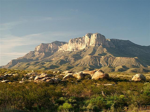
containing Guadalupe Peak, the highest point in Texas with an
elevation of 2,667 meters. It also contains the El Capitan peak,
long used as a reference on the old mail route called Butterfield
Overland. Visitors can see the ruins of the nearby Pine Springs
visitor center station. Guadalupe Mountains National Park covers an
area of 350 km2 in the same mountain range as the Carlsbad Caverns
National Park which is located about 129 km (80 miles) north of New
Mexico.
Guadalupe Mountains National Park also contains the
McKittrick cannon.
The entrance fee for adults is
$5; children under 16 are free. The fee is good for seven days.
There are several passes for groups traveling together in a
private vehicle or individuals on foot or on bike. These passes
provide free entry at national parks and national wildlife refuges,
and also cover standard amenity fees at national forests and
grasslands, and at lands managed by the Bureau of Land Management
and Bureau of Reclamation. These passes are valid at all national
parks including Guadalupe Mountains National Park:
The $80
Annual Pass (valid for twelve months from date of issue) can be
purchased by anyone. Military personnel can obtain a free annual
pass in person at a federal recreation site by showing a Common
Access Card (CAC) or Military ID.
U.S. citizens or permanent
residents age 62 or over can obtain a Senior Pass (valid for the
life of the holder) in person at a federal recreation site for $80,
or through the mail for $90; applicants must provide documentation
of citizenship and age. This pass also provides a fifty percent
discount on some park amenities. Seniors can also obtain a $20
annual pass.
U.S. citizens or permanent residents with permanent
disabilities can obtain an Access Pass (valid for the life of the
holder) in person at a federal recreation site at no charge, or
through the mail for $10; applicants must provide documentation of
citizenship and permanent disability. This pass also provides a
fifty percent discount on some park amenities.
Individuals who
have volunteered 250 or more hours with federal agencies that
participate in the Interagency Pass Program can receive a free
Volunteer Pass.
4th graders can receive an Annual 4th Grade Pass
that allows free entry for the duration of the 4th grade school year
(September-August) to the bearer and any accompanying passengers in
a private non-commercial vehicle. Registration at the Every Kid in a
Park website is required.
In 2018 the National Park Service will
offer four days on which entry is free for all national parks:
January 15 (Martin Luther King Jr. Day), April 21 (1st Day of NPS
Week), September 22 (National Public Lands Day), and November 11
(Veterans Day weekend).
Archaeological finds have shown that the area was
settled around 10,000 years ago. Hunters united here, followed large
herds of animals and began to collect edible plants in this area. This
is suggested by finds of projectiles, baskets, pots and rock paintings.
The first European settlers were the Spaniards, who, coming from the
south, passed through the area for the first time in the 16th century.
However, they initially showed no great reason to settle here.
Notwithstanding, they brought horses to the region, which were adopted
by the native Apaches as a great asset for their hunting and trekking
activities.
The Mescalero Apaches followed herds of animals and
began to use the native agaves for their sustenance in the area around
what is now the park. Fire pits used to grill agaves can still be found
in the park today. The Mescaleros remained in this area until the
mid-19th century, when they were driven out by the consequences of a new
transport route. The Butterfield Overland Mail route ran from Memphis to
San Francisco over the 1,687 meter high Guadalupe Pass. In 1858, Pinery
Station was established near Pine Springs in what is now the National
Park. Its aim was to protect the overland transports from raids by the
local Indian tribes. Part of the 9th Cavalry Regiment was stationed here
especially for this purpose. In the winter of 1869, this unit destroyed
two Indian settlements, after which the residents were resettled on
nearby reservations.
One of the first permanent settlers in this
area was Felix McKittrick. McKittrick Canyon was named after him. He
worked here as a cowherd.
The first permanent building in the
area was the Frijole Ranch, established in 1876 as a post office and
meeting place. Williams Ranch, named after its resident James A.
Williams, was added later. All buildings were united under the name
Guadalupe Mountain Ranch.
The beauty of McKittrick Canyon
prompted Wallace Pratt, a geologist with the Humble Oil and Gas Company,
to purchase 6,000 acres (2,400 ha) of the land in 1921. He used it as a
summer residence for his family until he donated it in 1960. As a
result, the Guadalupe Mountains National Park was formed and opened to
the public in 1972.
The Guadalupe Mountains are one of the world's finest examples of
a fossilized underwater reef. Its age is estimated at around 260 to
270 million years. By that time, a tropical ocean had covered much
of what is now Texas and New Mexico. Over millions of years,
calcareous mosses, algae and other underwater organisms settled in
the water and together with lime formed the roughly 400-mile-long,
horseshoe-shaped Capitan Reef. Later, as the sea evaporated, this
reef sank and disappeared under a massive layer of sediment and
minerals. It remained in this state for millions of years, until
upwelling forces drove some parts out of the ground and exposed
them.
Today, part of the reef towers over the largely flat
eastern Chihuahuan Desert as the Guadalupe Mountains. Other parts of
Capitan Reef have also been exposed and are now known as the Apache
Mountains and Glass Mountains.
The base of the Guadalupe Mountains lies at an altitude of 1,200 to
1,500 meters above sea level. The highest point is the 2,667 meter high
Guadalupe Peak and at the same time the highest point in the US state of
Texas. From here the mountain range stretches north-east and north-west
to New Mexico. The southwesternmost extension of the Guadalupe Mountains
is the peak of El Capitan, which rises approximately 1,000 meters above
the surrounding area of the Chihuahuan Desert. Basically, the territory
of the national park can be divided into three types of landscape:
desert, valleys and high mountains.
Desert
Guadalupe Mountains
National Park is surrounded by the sparsely populated areas of the
Chihuahuan Desert. This largely arid landscape stretches hundreds of
kilometers south, reaching well into Mexico. There is only 25 to 50
centimeters of precipitation per year here and the temperatures rise to
well over 35 degrees Celsius. Nevertheless, you can find a diverse flora
and fauna here: agaves, prickly pear cactus, coyotes, lizards and snakes
use the desert as their habitat.
Valleys
Mild temperatures,
shade and wind from the mountain slopes favor a lively development of a
rich flora and fauna in the deep, incisive valleys. This is best seen in
McKittrick Canyon, which is a mix of mid-mountain, high-mountain and
desert. Here you can find prickly pear, willow, Texan strawberry,
walnut, juniper and golden pine. The wildlife is characterized by
rabbits, coyotes, porcupines, gray foxes, mule deer, mountain lions and
moose, among others.
A local specialty is the Texan strawberry
tree, with its evergreen leaves and soft, reddish-brown bark. In autumn,
its red fruits provide rich food for birds.
high mountains
In
the high mountain ranges of the Guadalupe Mountains National Parks, a
dense forest consisting of Ponderosa pine, Weymouth pine, Douglas fir
and aspen thrives. This developed around 15,000 years ago when the
climate in this region was considerably warmer and wetter. Much of it
has disappeared as a result of global warming, but parts have survived
at higher altitudes. The forest in the “Bowl”, a plateau about 4
kilometers wide, is particularly lush. Home to moose, mule deer, turkey,
vultures, mountain lion, black bear, golden eagle and peregrine falcon
among others.
The original elk population in the national park
was never particularly large, but was completely wiped out by hunting
activities in the early 20th century. Today's populations are all from a
small group of animals brought here from Wyoming and South Dakota in the
1920's. It is estimated that 30 to 40 animals live in the park today.
The Guadalupe Mountains have relatively high summer temperatures, mild fall days and cold winters. Blizzards, freezing rain and fog are not uncommon in winter. Rain showers in late summer often trigger thunderstorms. Nights are usually cold, even in summer.
The park does not have a central entrance gate and toll booth, as is
common in most national parks in the USA. The park is accessible from
the south (El Paso) or east (Whites City) on Interstate 180. The central
contact point is the Pine Springs Visitor Center. Here you pay the daily
fee if you do not have an annual pass. You can also get your wild
camping permit here. A smaller part of the park with the Dog Canyon can
only be reached from the north via the New Mexico State Road NM-137. It
is not connected to the rest of the park's road network.
There is
no food supply in the park. The closest limited-edition store is at the
entrance gate to Carlsbad Caverns National Park in Whites City. There is
also a gas station here. The park also has no showers if you plan to
stay overnight.
Hiking and camping are among the most popular
activities in the national park.
hiking trails
The park has
more than 130 km of excellent hiking trails of varying difficulty. Watch
out for cacti, snakes and scorpions.
Guadalupe Peak
The trail
to the highest point in Texas (8,000 feet above sea level) is very steep
and rated as difficult, but is well maintained. Some sections lead along
high cliffs. The difference in altitude between start and finish is
around 1,000 meters. The way there and back (same route) total about 9.5
kilometers. You should plan six to eight hours for this. The path should
be avoided on windy or thundery days.
Devil's Hall Trail
The
path leads along the riverbed of Pine Spring Canyon, over some rocks up
to the so-called Devils Hall. The rocky path has only a slight increase
in altitude and leads through maple and pine forests, past typical
vegetation of the Chihuahuan Desert. The round trip, totaling seven
kilometers, takes about three to five hours.
the bowl
After a
climb of about 750 meters you are greeted by a dense coniferous forest
that covers the numerous cliffs and valleys. The trail is classified as
difficult and you should plan eight to ten hours for the 15 kilometers.
McKittrick Canyon
The hike in scenic McKittrick Canyon follows a
river bed, first in the Chihuahuan Desert landscape and later, with
increasing elevation, into a densely forested valley. The destination of
the trail is the Pratt Lodge. The round trip is about eight kilometers.
From here a trail leads deeper into the valley to the Pratt Cabin and a
grotto.
More hiking trails
El Capitan
Frijole Foothill
Trail
Permian Reef Trail
The Pinery Trail
Smith Spring Trail
Camping
The national park has two campgrounds that are accessible
by car: Pine Spring Campground and Dog Canyon Campground. A further ten
places can be reached via hiking trails. All seats are “first come,
first served”, i.e. they cannot be reserved. You have to try to find a
free place on site as early as possible. Due to some forest fires in the
past, there is a ban on campfires throughout the park, but the use of
gas cartridges is allowed.
In addition to numerous hiking trails and campsites, the park has a
few small museums and former ranches that are intended to bring the life
of the former inhabitants of this region closer.
The Frijole
Ranch History Museum shows how people used to live in the Guadalupe
Mountains. The complex includes a small school building, sleeping
quarters, a stable and a spring. There is also a picnic area nearby. In
the summer of 2016, the facility was closed for renovations.
The
Pinery is the remains of a station on the Butterfield Overland Mail
route from Memphis to San Francisco. It went right through the Guadalupe
Mountains. The facility is accessible via a one kilometer paved road
from the Pine Springs Visitor Center.
The former Williams Ranch
is located somewhat remote from the center of the park and can only be
reached by four-wheel drive vehicle. The dirt road uses the former
Butterfield Overland Mail Route routing for some sections. Access to the
building requires a key and permit, which can be obtained from the Pine
Springs Visitor Center.