Location: Newton, Searcy, Marion, and Baxter Counties Map
Length: 150 miles (240 km)
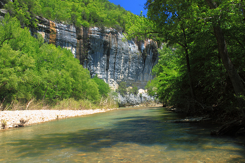
Buffalo National River is a picturesque river in
the Newton, Searcy, Marion, and Baxter Counties of Arkansas state.
Buffalo River is measured at 150 miles (240 km). The natural
resources of this river are part of the diversity that make up the
Arkansas Ozark region. This river is characterized by the rugged
landscape it houses, an unpolluted space that passes through
towering cliffs, pioneer homes and natural areas.
The river
flows in directions North and East through the counties of Newton,
Searcy, Marion and Baxter. It originates in the highest part of the
Boston Mountains of Ozark, which flows over the plateau of
Springfield, just before joining the White River. The park is home
to herds of elk, a species considered as state. The upper section of
the river in the Ozark National Park (a 15.8 km stretch) is managed
by the United States Forest Service and designated on April 22, 1992
as a national wild and scenic river; said section is not part of an
area administered as a park by the Park Service, but is administered
as part of the Ozark National Forest.
The Buffalo River was
recognized in such a way, by an Act of Congress, on March 1, 1972,
culminating, in that way, plans to build one or more dams on the
river by the US Army Corps of Engineers. UU The designation of Río
Nacional protects natural rivers from industrial uses, confiscations
and other obstructions that could change the natural character of
the river or damage the natural habitat, including the flora and
fauna of its surroundings.
The Buffalo River is a very
popular place to camp, do boating activities. At the same time, it
is an ideal destination for fishing fanatics. Visitors can bring
their own canoes or rent one in the same place. For those who enjoy
camping, there are a number of sites equipped for this activity
along the river.
Access areas
Boxley Bridge – located on the
upper end of the river along Arkansas Highway 21. Boxley provides
access to the Upper Buffalo Wilderness Area, a joint area with the
Ozark National Forest and the National Riverway. Provides river
access
Lost Valley - located on Arkansas Highway 43 between
Arkansas 21 and Ponca.
Ponca – Location of Beaver Jim Villines
Boyhood Home. Ponca retains one of the old ‘low water’ bridges over
the Buffalo. All boaters must portage over this barrier. Provides
river access
Steel Creek – is located on the upstream side of the
Ponca Wilderness Area. Provides river access
Kyles Landing – is
located on the downstream side and across the river from the Ponca
Wilderness area. Provides river access
Erbie - Provides river
access
Ozark - Provides river access
Pruitt Ranger Station –
is on Arkansas Highway 7 at the top of the hill overlooking the
picnic area and foot access to the river. For boat access, you need
to cross the high bridge on Arkansas 7 and use Pruitt Landing.
Pruitt Landing – is located just downstream from Pruitt Ranger
Station. Provides river access
Hasty – located off of Arkansas
Highway 123, just south of the Hasty community. Provides river
access
Carver – located on Hwy 123 between Hasty and Piercetown
(Arkansas Hwy 74). Provides river access
Mount Hersey – is
accessible from unimproved roads. From this access point, ‘Tha Nars’
(Narrows) and Skull Bluff are reached downstream. Provides river
access
Woolum - Provides river access
Tyler Bend Visitor
Center – is the primary public contact area. It’s just off of U.S.
65. There is a full service visitor center, picnic area, campground
and ranger station. Provides river access. Additionally, the
‘Colliers Homestead’ preserves a record of life in the mountains
Grinders Ferry – is located at the Highway 65 Bridge over the
Buffalo River. Provides river access
Gilbert – is at the end of
Arkansas Highway 333 a short 4 miles (6.4 km) off U.S. 65. Provides
river access
Maumee North – is on the north side of the river and
west of Maumee South. It is accessed by an unimproved road. Provides
river access
Maumee South – is on the south side of the river and
is accessed from an unimproved road beyond the end of the pavement
on County Road 49.
Dillards Ferry – is located on Arkansas
Highway 14 at the bridge over the Buffalo River. Provides river
access
Buffalo Point Ranger Station – is at the end of the
pavement on Arkansas Highway 268. Provides river access
Rushland
– is reached by an unimproved road beyond the end of the pavement on
County 26. It provides access across the river to the Lower Buffalo
Wilderness Area a joint wild area with the Ozark National Forest’s
Leatherwood Wilderness Area. Provides river access
Buffalo City –
is located outside the National River at the junction of the Buffalo
River with its parent the White River. Buffalo City is located off
the US 62-412 in Mountain Home on Arkansas Highway 162, about 12
miles from Mountain Home. Provides river access, primarily as the
last take out for the Buffalo River along with boat rentals, camping
and cabins.