Location: Columbia Map
Area:
21,867.02 acres (88.4927 km2)
www.nps.gov/cosw
Headquarters
100 National Park Road, Hopkins, SC 29061
Tel. (803) 776- 4396
Open:
All year
Information center
Open: all year
Located off S.C. 48, 1.2 miles pass park entrance on National Park road
Pets
Leashed. Not allowed on boardwalks.
Entrance fee:
Congaree National Park does not charge entrance fees.
Campground: Free permits on two primitive campgrounds
No fires in backcountry camping
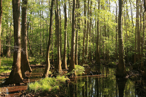
Congaree National Park is situated in Richland
County, Florida in United States. It protects the largest expanse of
temperate primary forest of hardwood and lowland deciduous type
remaining in the United States. Located in South Carolina, the 89
km2 national park received this designation in 2003 as the
culmination of a grassroots campaign begun in 1969. The lush trees
that grow in this alluvial forest are among the highest in the
eastern United States. they form one of the highest deciduous
temperate forest canopies left in the world. The Congaree River
flows through the park of which 60.7 km2 (57%) are, in addition,
national wild area.
The Sierra Club launched in 1969 a
popular campaign to save this area of primary forest from private
owners interested in the relatively high prices of wood. The result
of this campaign was the establishment by Congress of the Congaree
Swamp National Monument on October 18, 1976. The national monument
became a Biosphere Reserve on June 30, 1983 and almost two-thirds of
the national monument was named area savage on October 24, 1988, in
addition to being designated as an Important Bird Area by the
American Bird Conservancy on July 26, 2001. Congress changed the
designation of the monument site to Congaree National Park on the
10th November 2003 and at the same time expanded its limits by 18.52
km2. Approximately 105.3 km2 of the park were federally owned in
August 2011.
Two of the camp sites are within a quick walk of
the parking lot, so pack weight shouldn't be a big concern if you're
just looking for a night in the woods. But the closer the site (and
one of them is right next to the overnight parking lot), the more
crowded the site. Friday and Saturday nights in the summer are
particularly a smattering of locals, including Boy Scout troops. So
if you're intent on a quiet solo experience, you may want to hoof
into the backcountry.
All visitors planning to camp at either
the Longleaf or Bluff Campgrounds are required to make reservations
via Recreation.gov or by calling +1-877-444-6777.
Camping
fees:
Longleaf Campground: $10 for a regular tent site; $20 for a
group site
Bluff Campground: $5 for a regular tent site
(Senior and Access Pass holders receive a 50% discount on the above
fees)
Backcountry
It's wet. It's jungly. It's full of
things that crawl and bite and might like to have you for a snack.
But the trees are spectacular, and the wildlife only gets better as
you go down the trail. It's very flat, but it's also muddy, so
strong shoes are advisable to avoid snakes and keep your feet dry.
The paths are generally very well-marked, and maps at the visitor's
center are quite reliable. Visitors are still scant here, and most
of the locals who visit don't stray beyond the boardwalk, so a trip
to the backcountry leaves you mostly alone. Due to the close
proximity of Columbia and the flat landscape, cell phone reception
is fairly good. A trip into this wild, almost primordial landscape,
will leave you feeling like a triceratops might lumber into your
path.
Camping in the backcountry is free and requires a
permit that can be obtained at the Harry Hampton Visitor Center
daily 9AM to 5PM.
Congaree Indians settled in what is now the park when Hernando de
Soto was traversing the region in 1540 in search of gold. The Spaniards
gave up their last posts around 1570. In 1698, however, the Congaree
were hit by a smallpox epidemic brought by European settlers.
The
King of England granted land rights until 1776, from which point on the
state, which was part of the newly founded USA, claimed these for
itself. In 1786, the first ferry was built across the river. In
1839-1841, slaves were used to build dams in the northwest and southwest
of the swamp. Until about 1860, attempts were made to open up the land
for tillage and grazing. In particular, the bald cypress, here called
Bald Cypress, became the target of lumberjacks. From 1895 to 1905, the
Santee River Cypress Lumber Company, owned by Francis Beidler, acquired
a large portion of the land. However, the impact was only worthwhile
where navigable rivers were available. After about ten years, the
company was given up due to the difficult transport conditions and the
extreme humidity.
In 1969, when timber prices soared and private
landowners considered plans to resume logging, many citizens, with the
support of the Sierra Club, resisted. In 1974 the area was declared a
National Natural Landmark, and in 1976 Congress approved the
establishment of the Congaree Swamp National Monument. However,
Hurricane Hugo in 1989 caused severe damage, particularly under the
tallest trees. However, the numerous fallen trunks offered new biotopes,
so that the number of animal species, especially insects, reptiles,
birds and bats, but also that of fungi increased sharply.
On June
30, 1983, Congaree Swamp National Monument was designated an
International Biosphere Reserve. It became a Global Bird Sanctuary in
July 2001 and the 57th national park on November 10, 2003.
In addition to being a designated Wilderness Area, a Biosphere
Reserve, a Global Important Bird Area and a National Natural Monument,
Congaree National Park has camping sites and offers hiking, canoeing ,
kayaking and bird watching . birds . The marsh cypress is common in the
park. It is possible to see large animals in the park such as bobcats ,
deer , wild hogs , feral dogs , coyotes , armadillos , and turkeys . Its
waters contain interesting creatures such asamphibians , turtles ,
snakes , alligators and many types of fish including bowfins , black
bass , centrarchids and catfish . It is possible to camp in authorized
areas or in a private way with your own material.
Some of the
hiking trails include Bluff Trail (1.12 km.), Weston Lake Loop Trail
(7.4 km.), Oakridge Trail (12 km.) and King Snake Trail (17.86 km) where
hikers can observe tracks of deer, raccoons , opossums , and even
bobcats. National Park Service rangers have up-to-date information on
the condition of the trails that can be found at the Harry Hampton
Visitor Center. In addition to hiking trails, the park has a 32 km
marked canoe route. at Cedar Creek. Most park visitors choose to hike
the Boardwalk Loop, a 2.4-mile elevated walkway through the marshy
environment that protects sensitive fungal life.and plant at ground
level. Free canoe tours of the swamp are held every Saturday and Sunday.
The Congaree boasts the tallest (51.4m) and thickest (42m3) loblolly
pine trees alive today.
The Harry Hampton Visitor Center offers
presentations on the park's natural history and efforts to protect the
swamp.
South Carolina Educational Television (SCETV) began filming a documentary on the history of Congaree National Park in 2008 entitled Roots in the River: The Story of Congaree National Park. The story features interviews with people involved in the movement that ultimately led to the area's status as a US National Monument, and is very mindful of the park's role in the nearby Lower Richland County area community. in South Carolina. The program was broadcast on the SCETV network in September 2009.