Location: Alabama Map
Area: 13,633 acres (55.17 km2)
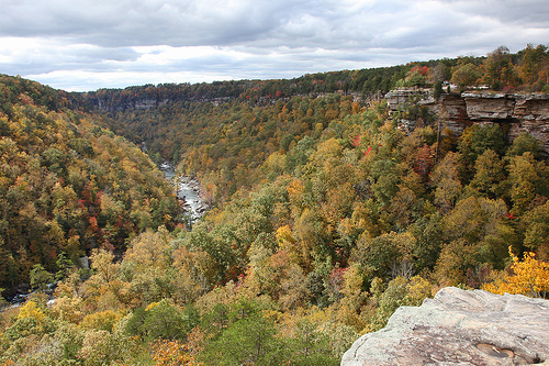
Little River Canyon
National Preserve or May's Gulf as it is locally known is a
nature reserve situated near Fort Payne, Alabama. Little River
Canyon National Preserve cover an area of 13,633 acres (55.17
km2) of Cherokee and DeKalb Counties. It is the deepest
geological formation east of Mississippi river. Little River
Canyon National Preserve is particularly beautiful in autumn
months when leaves of the trees change colors. The whole canyon
begins to look like colorful carpet spread on both sides of the
picturesque gulf.
DeKalb County A variety of rocky
outcrops and rocky cliffs create a unique environment for
various threatened and endangered species and for sporting
activities, such as kayaking and rock climbing. Unlike the case
of a national park, hunting and fishing are allowed in the
reserve.
Backcountry camping is allowed only in three
locations: Slant Rock, Hartline's Ford, and Billy's Ford.
Hunting in the preserve requires a hunting license from Alabama
or any other state. Riding ATVs is no longer permitted. Fishing
requires an Alabama fishing license and net or seine fishing are
not allowed.
Jacksonville State University Field Schools
(Little River Canyon Field School) offers outdoor education and
environmental education programs in DeKalb County and Cherokee
County in and around the canyon and preserve.
The river has not been dammed, except for a small, abandoned
hydroelectric project at DeSoto Falls on the West Fork near Mentone,
Alabama, and is considered one of the cleanest and roughest waterways in
the South. Sandstone cliffs rise up to 180 meters from the narrow canyon
floor and are clearly visible from the 37-km scenic drive known as the
Little River Canyon Rim Parkway (AL 176, DeKalb C.R. 148, Cherokee C.R.
275) on the canyon's western rim. The northern half of this road was
laid by the federal government during the New Deal era. The southern
half was constructed by local authorities.
The river has three
major waterfalls: DeSoto Falls, Little River Falls (at the beginning of
the canyon), and the seasonal Grace High Falls. Grace High Falls falls
into a side canyon created by Bear Creek and is the highest waterfall in
Alabama at 133 feet (41 m).
Eberhart Point, above the confluence
of the Little River and Bear Creek, is the most convenient point to
descend to the bottom of the canyon. Hikers can follow a rough, eroded
path. This is the remnant of a vehicle access road built in the course
of a ski lift and amusement park project that the state of Alabama
authorized a private consortium of Fort Payne businessmen to build in
the late 1960s. The project was abandoned a few years later, but the
associated debris can still be seen at Pine Tree Hall at the bottom of
the canyon. An unimproved but fairly well maintained trail leads about 8
miles to the mouth of the canyon. Only hikers accustomed to bushwhacking
should go upstream, as it is more difficult. The river is popular with
whitewater enthusiasts who carry their boats down to Pine Tree Hole.
Currently, camping is not permitted in the canyon.
Currently,
there are few National Park Service-operated visitor facilities in the
Preserve. DeSoto State Park, operated by the Alabama State Park System,
is located within the preserve and has a lodge, restaurant, campground,
and other facilities. At the entrance to the canyon is a day use area
that once housed a campground. This area is ideal for picnicking and is
also a popular swimming area.
There has been little land
acquisition since the New Deal era. The immediate vicinity of the Canyon
is being encroached upon by real estate speculation, vacation home
construction, and even subdivision development.
In the 1970s and
early 1980s, a mini-theme park (commercial venture) called "Canyonlands
Park" operated in the park area. There was a zoo and a lift. Parts of
the lift pedestal still remain in the park area.