Location: from Natchez Mississippi to Nashville, Tennessee
Total Length: 440 miles (710 km)
Natchez Trace is a historic Native American trails runs from Natchez, Mississippi to Nashville, Tennessee states of United States. Natchez Trace is thousands years old and was probably originally trumped by bison and deer. Later Choctaw and Chickasaw connected the road and used as a trade route. Arriving Europeans started using this route and in 1801 government signed a peace treaty with Choctaw that allowed Europeans passage. This attempt to secure travel via Natchez Trave only partially helped the situation. Natchez Trace gained fame for its cutthroat gangs. Today it is known as a Natchez Trace Parkway that stretched for a length of 444 miles (710 km). Numerous campgrounds, picnic sites are found along the trail. Also a visitor centre near Tupelo, Mississippi (birthplace of Elvis Presley) can help with directions and maps.
Mainly following a geological escarpment, prehistoric animals
followed the dry ground between the salty areas of central Tennessee to
pastures south of the Mississippi River.
Long after the arrival
of Native Americans, the necessities of hunting bison, deer, or other
game species meant traveling farther and farther until the path was
(relatively for that time) well marked. and accessible to riders in
single file. The Spanish explorer Hernando de Soto probably traveled
this trail.
The first man of European origin to have related in
1742 his route on the Natchez trail and its “miserable conditions” is an
unknown French explorer, traveling through the territory of New France,
in particular French Louisiana. For Europeans unaccustomed to the rigors
of homelessness, help from Native Americans like the Cherokees,
Choctaws, and Chickasaws was vital.
In 1792, a French-Canadian
trapper and explorer, Louis LeFleur, established a trading and trading
post on the Natchez Trail on a promontory overlooking the Pearl River. A
village grew up around this trading post.
After Napoleon I sold
Louisiana to the Americans, this LeFleur outpost was named LeFleur's
Bluff and was chosen as the location for the future Mississippi state
capital, Jackson.
About 1785, white farmers from the valleys along the Ohio River and
the Tennessee River, the so-called Kaintucks, began rafting their goods
down the rivers and on to the Mississippi River and on to Natchez and
New Orleans. As they could not stake their barges up the river, it
became common for them to sell these in either New Orleans or Natchez,
and from there they would return to their point of departure by the
Natchez Trace. During this period, the road was expanded and improved,
not least when the US Army began to use the road as a mail route in
1801, and in 1809 it was possible to travel on it by horse-drawn
carriage. In 1810, it was the busiest road in the South West Territory.
Along the way, with approx. 20-30 kilometer distance, "inns" ("stands")
were set up. When there were most people (around 1820), there were 20
inns along the road. Many of the inns were just a half-roof where the
travelers could seek shelter, and the innkeeper could usually also
deliver a meal. A few inns were what we understand by the term today,
with real rooms etc.
Some of the first settlements in Mississippi
also arose along the way, including Washington (which was the state's
first capital), Greenville, Tupelo, and also the current capital,
Jackson, Mississippi, located close to the Natchez Trace.
Despite
the inns, traffic on the road was not always pleasant. The road led,
among other things, through unpleasant swamps, plagued by poisonous
insects, snakes and predators, and although the Indians were helpful to
the first explorers, this did not last, as more and more whites
penetrated the area, then also attacks by hostile Indians, vasr a risk
when traveling. In addition, travelers were often attacked by bandits.
Especially the southern part of the road was notorious. Here the
travelers were within reach of the unlucky elements that dwelled in
Natchez Under the Hill, a small "town" at the foot of the cliff on which
Natchez itself is situated. This "city" was home to gamblers,
prostitutes and criminals of all kinds. But also at other places along
the road there was a risk of the travelers being attacked, and having
the money that most of them had with them stolen as payment for the
goods they had sold in Natchez and New Orleans.
In 1812, the
first steamship arrived in Natchez, and eventually boat transport was
established up the river. This meant that it was faster and not least
safer to sail than to walk/drive, and gradually the road began to decay
and in 1830 it was officially closed as a road, after which it was
allowed to decay.
Meriwether Lewis, organizer of the Lewis and Clark Expedition, and
appointed Governor of the Louisiana Territory (in March 1807), died
mysteriously on the Natchez Trail on October 11, 1809. En route to
Washington, he had stopped at the Grinder's Stand near present-day
Hohenwald, Tennessee for a bite to eat. Very depressed by the state of
his finances (he was heavily in debt), and by his marital failure, he
got drunk as he had already done on several occasions during his trip,
then he asked the landlady for powder to drink. rifle, which she gave
him, intimidated by his behavior. A few hours later, two shots rang out
in the night: Lewis had apparently shot himself once in the head and the
other in the chest. He survived until morning.
For a long time we
thought of suicide. But little by little details emerged which raised
other hypotheses: had one of his rivals, particularly Robert Grinder,
owner of the inn, killed him and then robbed him? Or was it a political
assassination against then Louisiana Territory Governor Lewis?
In
1996, James E. Starr, a professor at George-Washington University, tried
to obtain authorization for the exhumation of the 160 descendants of
Lewis. The National Park Service, which oversees the grave site in
Hohenwald, refused permission.
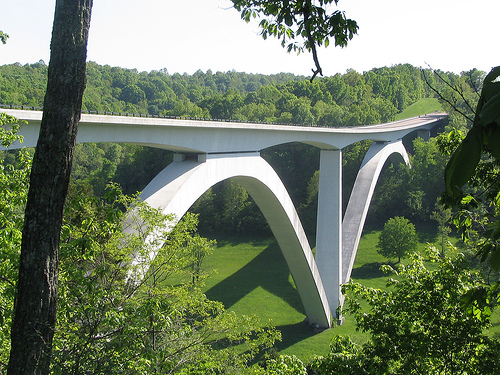
In 1939 construction began on the Natchez Trace Parkway, a 715 km
road from Washington, Mississippi (just outside of Natchez) to Fairview,
Tennessee (shortly before Nashville). The road passes through the states
of Mississippi, Alabama and Tennessee, and it broadly follows the old
Natchez Trace. The final portion of the Natchez Trace Parkway was
completed as recently as 2005.
Along the Natchez Trace Parkway
are several historic sites and memorials, including a Meriwether Lewis
Museum, a recreated inn, remnants of Native American villages, and more.
The road runs through an old agricultural area, and the entire road and
the adjacent areas function as a large national park of around 18,000
hectares. The park has its own Visitor Center in Tupelo, where you can
also see Elvis Presley's birthplace.
Sights along the way
Mileposts are counted from Natchez, Mississippi:
Milepost 15: Mount
Locust. A recreated inn from the heyday of the road.
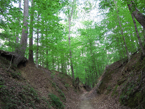
Milepost 41.
Sunken Trail. Remains of the original road, here as a hollow road.
Milepost 61: The boundary between the white settlers of southwestern
Mississippi and the Choctaw tribe.
Milepost 105. Ross Barnett
Reservoir Overlook
Milepost 108. The border between the Republic of
West Florida and the United States.
Milepost 180. French Camp. One of
the old inns that was converted into a school in 1822, and functioned as
such right up to our time.
Milepost 213 Line Creek. The boundary
between the Choctaw and Chikasaw tribes. One of the few places where an
actual border existed between two Indian tribes.
Milepost 266. Tupelo
National Battlefield.
Milepost 308. State line between Mississippi
and Alabama.
Milepost 341 State line between Alabama and Tennessee
Milepost 385. Grave of Meriwether Lewis.
Milepost 423: Here was the
border between the United States and the Chikasaw tribe when Tennessee
became a state in 1796.