Location: San Juan County Map
Area: 318 acres (1.3 km2)
Constructed: 11th- 13th centuries
Aztec Ruins National Monument is situated in San Juan County,
New Mexico in United States. It is located near the city of
Aztec and northeast of Farmington, near the Animas River. The
Salmon ruins and Heritage Park, with more ancestral structures,
are located a short distance to the south, just west of
Bloomfueld and near the San Juan River.
Aztec Ruins
National Monument covers an area of 318 acres (1.3 km2) and
protects ruins of the Anasazi settlement that was created
between 11th and 13th centuries. Its name is derived from a
mistaken romantic belief that it belonged to the Aztec tribes.
Early European settlers that initially stumbled on the ruins of
the settlement assumed that it belonged to the Aztec
civilization that spread their great empire to the American
Southwest. Aztec Ruins were added to the UNESCO list of World
Heritage Sites.
The place was declared a National
Monument of the Aztec Ruins on January 24, 1923 by Presidential
proclamation of Warren G. Harding, and with a change of
boundaries it was renamed "ruins" on July 2, 1928. As a
historical property of the Service of National Parks, the
national monument was listed administratively in the National
Register of Historic Places on October 15, 1966. The Aztec Ruins
was added to the list of World Heritage Sites of Unesco, as part
of the National Historical Park of the Chaco Culture on December
8, 1987.
The property was part of a 160-acre (65 ha)
homestead owned by H.D. Abrams, who supported the ruins
preservation. The H.D. Abrams House in Aztec is listed on the
National Register of Historic Places.
Discovery
The first records were made in 1859 by
the geologist Dr. John S. Newberry, who found the pueblos relatively
well preserved at the time. In the following 50 years, however, they
fell victim to isolated looting. When anthropologist Lewis H. Morgan
visited the site in 1878, he found that about a quarter of the stones
had been removed by settlers to be reused as building material. Only
when the land came into private ownership in 1889 was it relatively
spared from further destruction and finally came under national
protection in 1923 with its designation as a national monument.
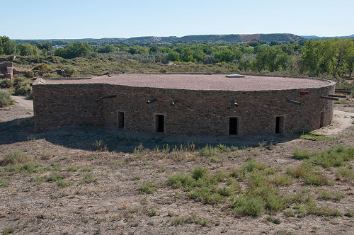
Earl Halstead Morris conducted the first systematic excavations in the
late 1920s. He spent the next seven years excavating the West Ruin, the
Great Kiva, and some rooms in the East Ruin. Among other things, in
addition to differences in the architectural style, he also discovered
that there must have been two different periods in the settlement. In
1930, reconstruction of the Great Kiva—a ceremonial room typical of
Pueblo culture—began under his supervision and was completed four years
later. In 1923 the ruins were declared a national monument.
colonization
Around 1111 the first settlement was built on this site,
which today forms the western ruins. In terms of construction, it is
similar to those in Chaco Canyon. It had three floors, contained over
400 rooms and several kivas, including the Great Kiva. In the decades
that followed, the settlement developed into a center of trade and
ceremonial events. With the waning of the Chaco culture, however, this
was already on the decline again by 1150. Added to this were the effects
of a period of drought.
The second settlement phase began around
1200. The pueblo was partially remodeled, existing unfinished buildings
completed. At that time, a second settlement was built off the beaten
track, today's East Ruin. The construction of this and the conversions
is similar to the buildings in Mesa Verde National Park. Pottery finds
also indicated a connection to this culture.
Around 1300 the
people left Aztec. The exact reasons for this are not known, possible
causes could have been another drought or a lack of raw materials.