Location: Montrose County, CO Map
Area: 30,244 acres
Activities: kayaking, camping, boating
The Black Canyon of the Gunnison National Park ("Black Canyon of the Gunnison National Park") is a national park of the United States located in the western part of the state of Colorado. It consists of a narrow and deep gorge belonging to the Gunnison River, having been established in 1933 and occupying an area of 83 km2. The park includes 19 km of 77 km of Gunnison River Canyon. Black canyon takes its name from its walls stained and full of lichen, which accentuate the darkness of the abyss. It was previously protected since 1933 as a Black Canyon of the Gunnison National Monument.
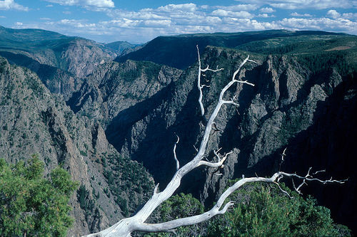
The Black Canyon is a deep gorge through which the
Gunnison River flows. It is so narrow that very little sunlight
falls to the bottom, making the walls look dark to black, giving the
canyon its name. At the Chasm Overlook lookout point it reaches a
depth of 555 meters at only 345 meters between the edges of the
gorge. In the Canyon, the Gunnison River has an average gradient of
18 meters per kilometer. In the 3.2-kilometer section between
"Pulpit Rock" and "Chasm View", however, the gradient is 50 meters
per kilometer. From the rim of the canyon, you can hear the roar of
the Gunnison river as it rushes through the gorge. The river digs in
for about three centimeters per hundred years.
The Black
Canyon of the Gunnison Canyon, visible today, dates back to the last
two million years when the Gunnison River dug through a Jurassic
sandstone stratum and hit the surface of a block of some 2 billion
years of Precambrian rock. It consists of gneiss pegmatite passages
showing a pronounced planar directional structure (foliation). The
resistance of the rock, which is under tremendous pressure over
geologically long periods of time, explains the almost exclusively
vertical erosion.
The entrance fee for a single visit to Black
Canyon of the Gunnison National Park is $15. It covers all persons
in a single, private, non-commercial vehicle and is valid for seven
calendar days. The entry fee for pedestrians, bicyclists,
motorcycles, motor scooters, or mopeds is $7 per person. There is no
fee charged for persons 16 years of age or younger. You can also buy
a Black Canyon Annual Pass for $30, which is valid for 12 months.
Also, a free permit is required for all backcountry and wilderness
use, both day use and overnight.
There are several passes for
groups traveling together in a private vehicle or individuals on
foot or on bike. These passes provide free entry at national parks
and national wildlife refuges, and also cover standard amenity fees
at national forests and grasslands, and at lands managed by the
Bureau of Land Management and Bureau of Reclamation. These passes
are valid at all national parks including Black Canyon of the
Gunnison National Park:
The $80 Annual Pass (valid for twelve
months from date of issue) can be purchased by anyone. Military
personnel can obtain a free annual pass in person at a federal
recreation site by showing a Common Access Card (CAC) or Military
ID.
U.S. citizens or permanent residents age 62 or over can
obtain a Senior Pass (valid for the life of the holder) in person at
a federal recreation site for $80, or through the mail for $90;
applicants must provide documentation of citizenship and age. This
pass also provides a fifty percent discount on some park amenities.
Seniors can also obtain a $20 annual pass.
U.S. citizens or
permanent residents with permanent disabilities can obtain an Access
Pass (valid for the life of the holder) in person at a federal
recreation site at no charge, or through the mail for $10;
applicants must provide documentation of citizenship and permanent
disability. This pass also provides a fifty percent discount on some
park amenities.
Individuals who have volunteered 250 or more
hours with federal agencies that participate in the Interagency Pass
Program can receive a free Volunteer Pass.
4th graders can
receive an Annual 4th Grade Pass that allows free entry for the
duration of the 4th grade school year (September-August) to the
bearer and any accompanying passengers in a private non-commercial
vehicle. Registration at the Every Kid in a Park website is
required.
In 2018 the National Park Service will offer four days
on which entry is free for all national parks: January 15 (Martin
Luther King Jr. Day), April 21 (1st Day of NPS Week), September 22
(National Public Lands Day), and November 11 (Veterans Day weekend).
The Valley of the Gunnison has been inhabited by the
Ute Indians since prehistoric times, and is thought to have been visited
by Spanish expeditions in the late 18th century, but the first reliable
account of a visit to the Black Canyon of the Gunnison was made in 1853,
during the expedition of John Gunnison. Gunnison's task was to
investigate a possible route for a railroad that ran along the
Kansas-Nebraska border. The expedition crossed the Rocky Mountains,
entered the valley of the river now called the Gunnison, and entered
Black Canyon on September 7th. Gunnison entered the canyon several times
on horseback and even suggested that a railroad could be built along the
bottom of the canyon. The expedition, however, did not try to pass the
canyon and turned south, after which it was almost completely carved
out, presumably by the Mormons.
In 1882, The Denver and Rio
Grande Railroad, in the course of building a railroad from eastern
Colorado to Salt Lake City, extended the rails to the town of Gunnison,
upstream of the Gunnison canyon. The company decided to build a canyon
railroad, and in August 1882, service began on the 24-kilometer track to
Cymarron. At the same time, it was decided to build a narrow-gauge
railway with a three-inch gauge instead of the usual gauge. This section
of the railroad, which lies above the modern national park, was a great
success with the public, and made a significant contribution to the
popularization of the Black Canyon as a tourist site. Passenger rail
traffic along the canyon continued until 1940, freight traffic until
1949, after which the road was abandoned. Much of this section was
flooded in the 1960s during the construction of the Blue Mesa Reservoir
on the Gunnison River.
Thus, in 1882, a decision had to be made
whether to drive the road through the canyon or drive it south of the
river to Montrose. It was necessary to first carry out survey work in
the canyon, for which the company hired Byron Bryant. Briant's
expedition traversed the entire canyon from December 12, 1882 to March
1883, and concluded that building a railroad through the canyon was
financially impossible.
In the 1880s, the Ute Indians, who lived
in the Uncompagre Valley, south of the canyon, began to move to the
reservation. In their place came white settlers who took up agriculture
and began to use the water of the Uncompagre River for irrigation. The
volume of water was insufficient, and the natural solution seemed to be
diverting water from the Gunnison River. In 1894, farmer Frank Lauzon
proposed the idea of a tunnel that would bring water from the Gunnison
to the fields. He conducted surveys, but the cost of the tunnel turned
out to be too high, and the project was not implemented. However, the
late 1890s were particularly dry, and in 1900 a party of five, led by
local resident John Pelton, decided to explore the Black Canyon.
Initially, they intended, starting from Cymarron, to sail along the
river through the canyon in wooden boats, but on the second day one of
the boats crashed, and part of the food supplies floated downstream. The
expedition managed to climb to the south side of the canyon. Pelton went
to Denver, where he became involved in campaign politics, tried to get
funding for the construction of a tunnel, after which he returned to the
canyon, and the group continued rafting. Unable to get through the
canyon to the end, they climbed the rocks to the north side of the
canyon and had to walk 15 miles to the nearest dwelling.
In
August 1901, the expedition of Will Torrance and Abraham Lincoln Fellows
managed to swim the entire length of the canyon, after which work on the
construction of the tunnel could begin. Construction began in 1904 and
was completed in 1909. The tunnel starts at the current border of the
national park and leads up to the left (south) bank of the river in
Luhan (now a ghost town). Further, the tunnel passes into the South
Channel in the Uncompagre Valley. The tunnel is still in operation and
is used for irrigation.
In 1916, Ellsworth Kolb and his
companions explored the canyon for the first time in terms of tourism
potential. Kolb made his first attempt to swim through the canyon in
July, lost his boat, returned by land to the beginning of the canyon,
and swam it on the second attempt, collecting a large amount of photo
and film material, as well as exploring the territories adjacent to the
canyon.
In 1933, the Black Canyon of the Gunnison National
Monument was formed, and on October 21, 1999, the monument was turned
into a national park.
The national park covers 124.44 km², making it one of the smallest national parks in the United States. The depth of the canyon in the park varies from 530 to 820 meters, the minimum width of the canyon is 12 meters. The canyon is located on the Colorado Plateau, a semi-desert plateau west of the Rocky Mountains, between the West Elk Mountains to the north, San Juan to the south, and Uncompagra to the west. Above the park, the Gunnison River is dammed to form the Blue Mesa Reservoir. In the park, the canyon first has an east-west direction, then turns to the northwest. Montrose-Gunnison Highway 50 runs along the south shore of the canyon, and Delta-Gunnison Highway 92 runs along the north shore.
The rocks that make up the canyon were formed in the Precambrian and are composed of metamorphic rocks, primarily gneisses and shales, with streaks of pegmatite. The age of these rocks in the park is about two billion years. Some formations in the lower part of the canyon are composed of sandstone and date back to the Mesozoic. The mountains surrounding the canyon are young and belong to the Cenozoic folding.
There are 66 species of mammals in the park, including
a large number of black-tailed deer, as well as, among others, baribal,
puma, coyote, wapiti, 176 species of birds, 16 species of fish, 11
species of reptiles and two species of amphibians. About 800 species of
plants grow in the park.
The park is located on the territory of
four natural zones. The canyon is located on the Colorado Plateau, and
its shores are semi-desert, characterized by isolated or growing small
groups of juniper and Colorado pine trees. Six species of juniper grow
in the park, of which the hard-seed juniper is the most common, and
eight species of pines. Also on the plateau, another natural area is
formed by thickets of oak Quercus gambelii, growing in the form of a
shrub. On the slopes of the canyon, where much less sunlight falls, fir
forests grow. Pseudo-hemlock and aspen predominate here. The southern
slopes of the canyon are steeper than the northern ones, so forests grow
mainly on the northern slopes. At the bottom of the canyon, along the
Gunnison River, there are water meadows, as well as tree species such as
poplar Populus angustifolia, bird cherry and ash-leaved maple. The
lampshade spider Hypochilus bonneti, endemic to Colorado, is found.
The only information center in the park is located on
the left (south) bank. There are three campsites - two on the south
coast and one on the north. On the southern coast along the canyon there
is a road with viewpoints, from which hiking trails depart. There are
opportunities for rock climbing, rafting and kayaking, fishing and other
activities.
There is no public transport in the park and near the
park borders. The nearest relatively large city is Montrose.