Location: Washington, Oregon Map
Depth: 4,000 feet (1,200 m) deep
Length: 80 miles (130 km)
The Columbia River Gorge Scenic Area: Tel. (541) 386 2333
Headquarters: 902 Wasco Ave, Suite 200, Hood River, OR 97031
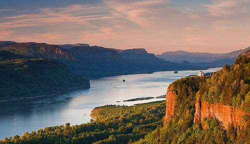
Columbia River Canyon is a canyon in the Northwest United States.
The depth of the canyon reaches 1200 meters, and its length is 130
kilometers. The canyon forms a natural boundary between the states
of Washington to the north and Oregon to the south. Approximately
from the confluence of the Columbia and Deschutes in the east to the
eastern parts of the Portland metropolitan area, the river gates
extend, which form the only shipping route through the Cascades and
the only water connection between the Columbian Plateau and the
Pacific Ocean. Highways I-84, US-30 and WSR-14 run along the canyon,
as well as railroad tracks on both sides of the river.
The
canyon is a popular recreational area and is a federally protected
National Scenic Area. It is administered by the Columbia River
Canyon Commission and the US Forest Service.
The Columbia,
Klamath, and Pete Rivers in northern California, and the Fraser
River in southern British Columbia, are the only rivers that connect
basins east of the Cascades to the Pacific Ocean. Each of these
rivers carved a gorge through these mountains. The Columbia River
Canyon is the border between the states of Oregon and Washington,
and the wide range of altitudes and rainfall in this area makes it
extremely diverse and dynamic. So, the canyon reaches a depth of
1200 meters, it has various ecosystems: rain forests in the west
with an annual rainfall of up to 2500 mm and grasslands with an
annual rainfall of about 250 mm. Endemic animals and plants occur in
isolated habitats, including at least 13 endemic wildflowers.
The canyon transitions from rainforest conditions to dry grassy
meadows in just 130 km, during which the landscape changes
dramatically, as is noticeable when driving along the I-84 highway.
In the western rainforests there are large-leaved maples, Menzies
pseudo-hemzies and western hemlocks covered with epiphytes. In the
transition zone between the towns of Hood River and The Dalles,
large vegetation is represented by Oregon white oak, yellow pine,
and a local variety of poplar. In the east, the forests give way to
vast meadows with occasional lodgepole and yellow pines.
The
difference in atmospheric pressure to the east and west of the
Cascade Mountains creates the effect of a wind tunnel in a deep
gorge, creating winds at speeds up to 56 km / h. Due to such winds,
the canyon is a popular place for windsurfing and kitesurfing. Due
to the same conditions, snow and ice storms occur during the winter
months with cold easterly winds at the mouth of the gorge at the
western end of the canyon.
The canyon is a popular
destination for hiking, biking, sightseeing, fishing and water
sports. The region features many waterfalls; for example, there are
more than 90 of them in the Oregon part of the canyon. Many of the
waterfalls are found on the Columbia River Historic Highway, among
them is the 190-meter Multnomah Falls.
Duration: 6 hours to 2 days
Distance: 12 miles
(19.3 km)
Difficulty: medium to medium- hard
Nearest town:
Cascade Locks
Public transport: none
The most popular hiking
trail in the area of Columbia River Gorge National Scenic Area is an
Eagle Creek Trail that can take up to 2 days to complete. This
historical trail is located on the Oregon side of the Columbia River
Gorge. It takes tourists along 11 picturesque waterfalls along a
narrow canyon. Depending on your personal wishes you can take
shorter route for several hours or turn it into a multiday hiking
trip.
Eagle Creek Trail in the Columbia River Gorge was created
in 1910's during engineering work on road construction of the
Columbia Gorge Highway. Parts of the hiking trail have no rails and
thus they can be dangerous to children and animals. The end point is
a beautiful Tunnel Falls that ends in the swimmable pool at the foot
of the cliff. An overnight 7 1/2 Mile Camp is a backcountry camping
site is located 1.5 miles pass the Tunnel Falls. Additionally there
are seven designated campsites along the distance of the trail.
Additionally some hikers make shorter day trips. This include trails
to Punchbowl Falls (about 4.2 roundtrip) or High Bridge Trail (about
7 mi roundtrip). However the trail to the Tunnel Falls doesn't end
there. You can explore Columbia River Gorge National Scenic Area
further by taking longer backcountry loops to viewpoints at Wahtum
lake and Benson Plateau by connecting via the Pacific Crest Trail,
Wy'East Trail No 434 and Ruckel Creek Trail No 405.
By car
From downtown Portland, simply take I-84
east toward The Dalles. From I-5 from outside the Portland metro
area, take the I-205 exit at either Tualatin, Oregon (exit 288 from
I-5 north) or Vancouver, Washington (exit 7 from I-5 south), and
follow signs to I-84 east toward The Dalles.
On foot
The
Pacific Crest Trail (PCT) is a well known trail that extends along
the West coast of the United States, from Mexico to Canada. It
passes through California, Oregon, and Washington State.
Interstate 84 is a great way to get around the gorge. Be sure to meander on the side roads like the "Old Columbia Highway" (Route 30), by taking exit 18 toward Lewis and Clark State Park/ Oxbow Regional Park. Take a left onto Crown Point Highway. Then take a right onto East Columbia River Highway. This road passes by multiple scenic locations such as Multnomah Falls, Punchbowl Falls, Eagle Creek and more.
The Columbia River Canyon began to form as early as
the Miocene (about 17-12 million years ago) and continued to take shape
in the Pleistocene (2-700,000 years ago). During this period, the
Cascade Range formed and slowly moved the Columbia Delta about 100 miles
north of its current location.
Although the river slowly eroded
its surroundings during this period of time, the most drastic changes
occurred at the end of the last ice age. Then, as a result of powerful
Missulian floods, the modern boundaries of the canyon were formed. As a
result of rapid erosion, many layers of volcanic rock were exposed.
Man began to inhabit the canyon over 13,000 years ago.
Archaeological excavations have found evidence of the presence of people
of the Folsom tradition and Marms Cave who crossed the Bering Bridge
from Asia. Excavations near Selilo Falls, a few kilometers east of The
Dalles, have shown that people have been fishing salmon here for over
10,000 years.
The canyon served as a transport corridor for
thousands of years. To trade at the Selilo Falls, the Indians crossed
the canyon both along Columbia and the Lolo Pass on the north side of
the Hood volcano. In 1805, the expedition of Lewis and Clark laid a
route along the canyon to the Pacific Ocean. Early European and American
settlers subsequently established a steamboat service on Columbia in the
canyon. Today, cargo on the Washington side of the canyon is transported
by the BNSF railroad, and the Oregon side of the canyon is transported
by the Union Pacific Railroad.
The Columbia River Highway, built
in the early 20th century, was the first major paved highway in the
Pacific Northwest. River cargo transportation in the canyon was greatly
simplified after the construction of the Bonneville and Dulles dams in
the middle of the 20th century.
In November 1986, the US Congress
granted the canyon the status of the second National Scenic Area in the
United States (Eng. National Scenic Area) and established the Columbia
River Canyon Commission. The canyon received such an alternative status
instead of being a recognized national park, which would require the
relocation of all industrial enterprises existing here from the region.
The canyon's status was criticized both by local residents who feared
production restrictions, and by environmental activists who foresaw the
possible further development of the industry.