Location: Eastern California Map
A seven-day pass with unlimited re-entry is $30
for a standard vehicle (car, truck or van) and $15 for each
individual traveling on foot, motorcycle, or bicycle.
There
are several passes for groups traveling together in a private
vehicle or individuals on foot or on bike. These passes provide free
entry at national parks and national wildlife refuges, and also
cover standard amenity fees at national forests and grasslands, and
at lands managed by the Bureau of Land Management and Bureau of
Reclamation. These passes are valid at all national parks including
Death Valley National Park:
The $80 Annual Pass (valid for
twelve months from date of issue) can be purchased by anyone.
Military personnel can obtain a free annual pass in person at a
federal recreation site by showing a Common Access Card (CAC) or
Military ID.
U.S. citizens or permanent residents age 62 or over
can obtain a Senior Pass (valid for the life of the holder) in
person at a federal recreation site for $80, or through the mail for
$90; applicants must provide documentation of citizenship and age.
This pass also provides a fifty percent discount on some park
amenities. Seniors can also obtain a $20 annual pass.
U.S.
citizens or permanent residents with permanent disabilities can
obtain an Access Pass (valid for the life of the holder) in person
at a federal recreation site at no charge, or through the mail for
$10; applicants must provide documentation of citizenship and
permanent disability. This pass also provides a fifty percent
discount on some park amenities.
Individuals who have volunteered
250 or more hours with federal agencies that participate in the
Interagency Pass Program can receive a free Volunteer Pass.
4th
graders can receive an Annual 4th Grade Pass that allows free entry
for the duration of the 4th grade school year (September-August) to
the bearer and any accompanying passengers in a private
non-commercial vehicle. Registration at the Every Kid in a Park
website is required.
In 2018 the National Park Service will offer
four days on which entry is free for all national parks: January 15
(Martin Luther King Jr. Day), April 21 (1st Day of NPS Week),
September 22 (National Public Lands Day), and November 11 (Veterans
Day weekend).
Unlike other national parks, few of the roads
into Death Valley National Park have road-blocking ranger-manned fee
booths. You are expected to pay the entrance fee though, and there
are automatic kiosks at several places in the park.
The valley got its name after two groups of travelers
with a total of about 100 wagons were looking for a shortcut of the Old
Spanish Trail in 1849 and ended up in the valley. After being unable to
find a way out of the valley for weeks and already being forced to eat
several of their oxen (using the wood from their wagons for fuel), they
abandoned their remaining wagons and exited the valley via Wingate Pass.
One of the women from the group turned around and shouted “Goodbye,
Death Valley” after the valley.
Despite a widespread legend, none
of the group is said to have died crossing the valley, except for an old
man named Culverwell, who was deathly exhausted when entering the
valley.[3] As a member of the tour group, William Lewis Manly described
the events in his autobiographical work Death Valley in '49.
Death Valley is part of the endorheic Great Basin. The
Amargosa Range bounds the valley to the east and the Panamint Range
separates it from the Panamint Valley to the west.
The Badwater
Basin is the deepest accessible point in North America at 85.95 meters
below sea level, about 2 meters lower than the basin filled by the
Salton Sea today. The highest point in the contiguous United States,
Mount Whitney (4421 m), is just under 140 kilometers northwest. After
heavy rainfall, the Amargosa River periodically flows through the valley
before its water seeps away or evaporates there.
There have been at least four periods of active volcanism, three or four periods of sediment deposition, and some plate tectonic shifts in Death Valley in the past. In addition, the area was glaciated at least twice.
The valley is rich in metals such as gold and silver, and minerals such as talc and borax. A mining company worked here for many years, extracting borax for soap production. The finished product was transported out of the valley in large wagons, each drawn by 18 mules and two horses. Hence the brand name 20-Mule-Team.
Although Death Valley is only a few hundred kilometers
from the Pacific Ocean, it is one of the driest places on earth. This is
because the humid winds on their way from the Pacific rain down five
ridges before they can sweep across the park's territory. Death Valley
is also one of the hottest places in America.
On July 10, 1913, a
temperature of 56.7 °C (134 °F) was recorded at Greenland Ranch (now
known as Furnace Creek Ranch) by the National Weather Service, which is
the highest temperature ever recorded on earth. However, some
meteorologists, supported by more recent studies, attribute this result
to an error in observation. While the 1913 reading continues to be
officially recognized as the world heat record, the temperature of 130°F
(54.4°C) recorded by an automated National Weather Service measurement
system on July 10, 2021 at Furnace Creek is the highest yet undisputed
on record air temperature measured on earth. A day later, another
station in Death Valley reported the highest nighttime temperature in
North American history at 42 °C (107.7 °F).
On July 12, 2012, the
then highest night-time temperature in the world was measured in Death
Valley at 41.7 °C (107 °F); this value was surpassed on June 17, 2017 in
al-Khazab in Oman on the Arabian Peninsula with 44.2 °C (111.6 °F).
After an unusually heavy rainfall for the area on August 5, 2022 (at
Furnace Creek 37 mm were measured), mudslides occurred and all access
roads were damaged. Hundreds of visitors who came by car were locked up
by the morning of August 7, cars were moved and damaged. In the history
of measurements since 1911, rain has only been measured once on a day.
The fauna is relatively diverse with over 400 species:
These include 51 native mammal species, 307 bird species, 36 reptile
species and three amphibian species. It is possible to encounter lonely
roaming coyotes, mostly thin in stature. These animals are able to feed
on almost all small animals and plant parts. They like to rummage
through the leftovers and other rubbish left by tourists. Other mammals
found in the park include kit foxes, bobcats, cougars and mule deer.
Snakes usually only leave their hiding place at night, while the more
numerous lizards inhabit rock crevices and crevices. Bighorn sheep live
in and around the park. These are a subspecies of mountain sheep that
live in small, isolated flocks in the Sierra Nevada and Death Valley.
These highly adaptable animals can eat almost any type of plant. They
have no natural enemies but compete with humans for habitat.
Death Valley National Park is a stopover and resting place for many
migratory birds on their way through: Swallows, ibises and mallards can
be observed, especially in spring. Only a few birds are native all year
round; this includes the great roadrunner, also known as the roadrunner.
Six species of fish from the Cyprinodontidae family live in the national
park: Five species belong to the genus of desert medaka, including the
endangered, endemic devil medaka, of which there were only around 100
specimens left in April 2011. Another species is the human-introduced
koboldfish, a highly invasive species of fish.
The national park has over 1000 plant species; this includes 23 endemic species. Vegetation varies with elevation: sparse shrubbery such as the creosote bush and scattered plants of the genera Prosopis and Reporten in the valley, Joshua yucca, Slender Pine and Long-life Pine in the higher elevations. Striking are salt herbs, bushes rolling around freely in the wind. Adaptation is key to surviving in one of the driest, hottest places in North America: Loggers can develop a root system up to 15 meters long to reach deep groundwater. The leaves of Atriplex hymenelytra are coated with salt on the surface; this leads to the reflection of the sunlight and thus to a reduction in evaporation. A few rainy days in winter lead to short flowering times in some regions of the park; nevertheless, neither the low rainfall nor the overall sparse biomass are sufficient to form even remotely fertile soil. Every few years it rains more than usual, including 2016, 2005 and 1998. Then Death Valley turns into a sea of flowers.
Artist's Palette
Artist's Palette is on the slopes
of the Black Mountains, which run parallel to the Panamint Range and
enclose a rift valley; it is famous for its multicolored rock
formations. The richness of color is caused by oxidation of various
metals found in the rocks; for example iron (red to dark red) or copper
(turquoise to green).
Badwater Basin
Badwater is the lowest
point in the United States (85.95 meters below sea level) (♁36° 13′ 49″
N, 116° 46′ 3″ W). The hexagonal structures seen here are around 2 to
2.5 m in diameter and are part of a much larger and also hexagonal
structure that can be observed from Dante's View, around 1750 meters
higher. These structures are created by drying and the associated
expansion of the salt crystals that occur here. There is a weather
station near the flat salt pan, where temperatures of over 50 °C are
regularly measured in summer. The salt pan was formed when a lake that
was up to 200 m deep dried up 3000 years ago.
Barker ranch
The
Barker Ranch site is located approximately 15 miles northeast of Searles
Lake and Trona, California. The exact coordinates are ♁35° 51′ 34.4″ N,
117° 5′ 17.4″ W. It can only be reached via unpaved sand and gravel
roads. Originally it was just a hut, built in 1937 by a former police
officer and expanded over the following years. After his death, his
widow sold the ranch to the Barker family. Barker Ranch became known as
Charles Manson's last hideout. He stayed there with his sect (the
so-called Manson Family) after they had committed brutal murders in Los
Angeles. The members of the sect were arrested in two raids at the ranch
on October 10 and October 12, 1969 respectively. The abandoned ranch is
now owned by the National Park Service. A ground survey was undertaken
in 2008 following indications that the bodies of other possible Manson
Family victims may be buried on the site. However, the suspicion was not
confirmed. In 2009, the buildings burned down in a fire.
Charcoal
Kilns
The site was established in 1867 to produce charcoal, which was
used to process ores found in Death Valley. However, the charcoal
burning was given up again just three years after it had started.
Dante's View
Dante's View overlooks Death Valley at an altitude
of 1669 m above sea level. Like Artists Palette, it belongs to the Black
Mountains. From there you can see the central part of Death Valley and
have a view of the Badwater Basin. You can also see the Telescope Peak
with its 3366 meter high summit. The valley stretches from left (south)
to right (north); in its center you can see a dry salt lake.
Devil's Golf Course
These jagged and jagged salt structures have led
early visitors to believe that this inhospitable place must have been
the devil's golf course.
Hidden Valley
The valley is in a
remote area on the western side of the Cottonwood Mountains above
Racetrack Valley. A variety of old abandoned mines are scattered
throughout the valley. The dried-up valley, with little vegetation in
summer, can turn into a snow-covered landscape in winter and surprise
with a sea of flowers in spring.
Lipscott Rd
The Lippencott
Road connects the racetrack to the Saline Valley. At the top of the
road, on the west side of the Cottonwood Mountains, is the old
Lippencott lead mine. Like many roads in Death Valley, the park
administration only maintains the Lippencott Road at irregular intervals
in order to limit mass tourism. Signs therefore warn against use with
off-road vehicles.
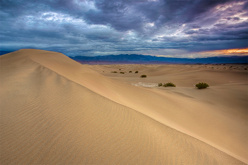
Mesquite Sand Dunes
Located in the northern
part of the valley, the 4km² Mesquite Sand Dunes have been used as a
desert backdrop many times in films including Star Wars. The largest
dune is the Star Dune. This is quite stable, since the wind tends to
deposit the sand at exactly this point. The sand here is around 50
meters high.
Mesquite Springs
Mesquite Springs is the
northernmost part of Death Valley. There are numerous cacti in this part
of the valley. Above the spring there are 2000 to 3000 year old
petroglyphs of the extinct Mesquite Springs culture.
Mosaic
Canyon
Mosaic Canyon is located in the northwestern mountainous part
of the valley. It is named for its patterned rock faces. The deposits
from different rock formations (breccia) form varied patterns. The
predominant rock deposit is dolomite, a type of limestone formed in a
warm shallow sea that covered the Death Valley area 750 million years
ago.
Racetrack Playa
The shifting rocks of Racetrack Playa
leave traces of movement across a nearly year-round dry lake bed. In
2014, the cause of the movements could be clarified with the help of GPS
and time-lapse recordings.
Rainbow Canyon
Rainbow Canyon runs
through the Inyo Mountains in the west of the park and connects the
lower Owens Valley in the west with the Panamint Valley in the east. It
is used by the US Air Force and US Navy pilots as a training ground for
low level and terrain following flight. Due to the depth of the canyon,
it is possible to watch the fighter planes in flight from above against
the ground.
Salt Creek
Most of Salt Creek is mostly dry and
covered in a brilliant white layer of salt. This is caused by regular
flooding and the subsequent evaporation of the water. Much of the salt
inflow comes from brackish streams that flow year-round. Here is also
the last remnant of the former Lake Manly.
Shoreline Butte
This mesa used to be an island in prehistoric lakes that filled Death
Valley during Ice Ages.
Telescope Peak
Telescope Peak is the
highest point in the park at 3,366 meters above sea level and is located
in the Panamint Range.
Titus Canyon
Titus Canyon cuts into a
Precambrian sea floor. Leadfield is a ghost town near Titus Canyon that
was founded in the 1920's after a rumor spread that mining in the area
was profitable.
Fix Crater
Ubehebe Crater is a maar about a
kilometer in diameter and up to 230 meters deep. Its age was originally
estimated at around 6000 to 7000 years; according to a more recent study
from 2012, the age is only around 800 years. Ubehebe is a Native
American word meaning "big basket in the rock". The crater was formed
when hot magma surged near the surface of the earth, explosively
evaporating groundwater.
Such phreatomagmatic explosions occurred
more frequently in the area, but Ubehebe Crater is the most striking
example. The coordinates are: ♁37° 0′ 35″ N, 117° 27′ 1″ W There is a
series of gray deposits near the crater rim; further down the deposits
become lighter. The gray deposits are from more recent, similar
explosions. The lighter deposits are old sedimentary rocks.
Ventifact Ridge
Ventifact Ridge is a ridge formed by lava flow. The
rocks found on this ridge are famous for having been eroded into a wide
variety of shapes by wind. The wind blows very strongly here, and the
sand that is thrown up acts on the rocks like a sandblaster.
Zabriskie Point
Zabriskie Point is known for its bizarre erosion
landscapes. The rock formations are the sediments of the former Lake
Zabriskie, which dried up nine million years ago.
Other locations
in the park
Aguereberry Point
Crankshaft Junction
Desolation
Canyon
Devil's Cornfield
Furnace Creek
Lake Manly
Myer's
ranch
Scotty's Castle
Skidoo
Stovepipe Wells
Willow Springs