Location: Southern Utah Map
Area: 1.9 million acres (7,689 km2)
Info: 755 W Main St, Escalante, (435) 826- 5499
Open: Mar- Oct: 7:30am- 5:30pm daily
Nov: 8am- 4:30pm daily
Dec- Apr: 8am- 4:30pm
Official site
Fees and permits: Camping is free in unimproved areas.
Grand Staircase-Escalante National Monument is situated in the Southern Utah in United States. Grand Staircase-Escalante covers a total area of 1.9 million acres (7,689 km2) and carries one of the best geological formations in the state. There are three main regions: the Grand Staircase, the Kaiparowits Plateau, and the Escalante Canyons, all managed by the Bureau of Land Management, part of the National Landscape Conservation System. President Bill Clinton designated the area as a national monument in 1996 thanks to the "Antiquities Act".
The national monument stretches from the cities of
Big Water, Glendale and Kanab in the southwest to the cities of
Escalante and Boulder in the northeast. Its size is comparable to
that of the State of Delaware. The western part of the Grand
Staircase-Escalante National Monument is dominated by the
Paunsaugunt Plateau and the Paria River Valley, on the eastern edge
of Bryce Canyon National Park.
This area allows you to view the upper geological layers of the
Grand Staircase.
The central section of Grand
Staircase-Escalante consists of an elevated area called
Kaiparowits Plateau when viewed from the west and referred to as
Fifty-Mile Mountain ("50-Mile Mountain") when viewed from the east.
This plateau extends from the southeast of Escalante to the Colorado
River. The western slope of the plateau is a gentle slope while its
eastern slope is a cliff 650 meters high.
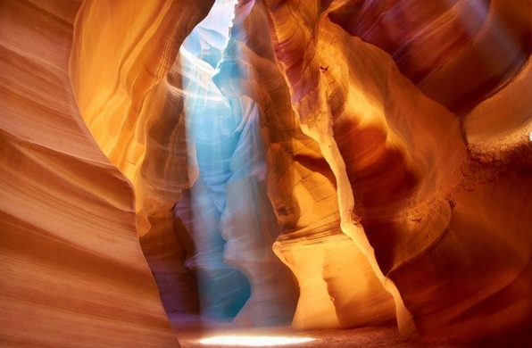
Canyon of Grand
Staircase-Escalante National Monument begin further east of this
plateau. This is an area composed of many canyons limited further
east by the Glen Canyon
National Recreation Area. This area is very popular with hikers.
Fly into Las Vegas, Salt Lake City or Phoenix and rent a car. From Las Vegas take Interstate 15 North or from Salt Lake City take Interstate 15 South. In either case take State Route 14 east from Cedar City to State Route 12 or US 89, which will take you through the Monument. From Phoenix take Interstate 17 North to Flagstaff and then continue north on US 89, which take you into the Monument. Four wheel drive is highly recommended on any but the primary roads, although not strictly necessary.
On December 4, 2017, President Donald Trump ordered a
Presidential Proclamation to almost halve the protected area and to
break up the National Monument into three only partially connected parts
(units). As justification, he stated that the original demarcation would
not have met the requirements of the legal basis and would have been
significantly too large. The remains of Grand Staircase-Escalante
National Monument are to be divided into three protected areas: Grand
Staircase National Monument, Kaiparowits National Monument and Escalante
Canyons National Monument. The right to reduce a national monument by
executive order is controversial and will be decided in court. A federal
court in Washington D.C. issued an interim order in September 2018,
which means that the area reduction will not take effect for the time
being. It obliges the Bureau of Land Management to notify the plaintiffs
of all interventions in good time before they begin, so that legal
remedies remain. During the monument's downsizing period, it was overrun
by motorized vehicles and tourists, threatening important cultural
artifacts.
On his first day in office, President Joe Biden signed
an executive order calling for a review of reducing the acreage of Bears
Ears and Grand Staircase-Escalante National Monuments. After the
election, the Bears Ears Inter-Tribal Coalition repeatedly urged Biden
not only to restore the monument to its original size, but also to
expand it to the 1.9 million acres, as the coalition had already
proposed to President Obama. In early April 2021, Home Secretary Deb
Haaland personally visited the area.
On October 8, 2021,
President Joe Biden reversed Trump's land reduction with a Presidential
Proclamation. Existing permits or leases for grazing livestock remain in
place. If grazing permits or leases are voluntarily given up by the
previous owners, grazing with cattle will be stopped. The green fodder
of these areas may no longer be used unless the BLM specifically
determines that such use furthers the goals of the Presidential
Proclamation. To the fullest extent permitted by law and in consultation
with the Native American tribes, the protection of sacred sites and
cultural assets and sites within the monument shall be ensured. Access
is granted to tribal members for traditional cultural, spiritual, and
habitual purposes in accordance with the American Indian Religious
Freedom Act and the Indian Sacred Sites Executive Order, including
collecting plants for medicine, berries and other crops, forest
products, and firewood for personal use commercial use.
At 7,689 km², the nature reserve is currently the
largest of its kind in the heartland of the USA. It is located in
southern Utah in one of the most remote areas of the USA, surrounded by
the Bryce Canyon and Capitol Reef National Parks, the Glen Canyon
National Recreation Area and Lake Powell and the Dixie National Forest.
The monument consists of rocky landscape and is geologically
essentially tripartite. To the west lies the area of the "Grand
Staircase", a layered landscape that forms the "Great Staircase" rising
to the north. The Grand Staircase is bisected by the Paria River, which
along with its tributaries cut through the landscape in many ways.
Further east, the Grand Staircase is joined by the Kaiparowits Plateau,
the driest and most inhospitable region of the monument. The boundary
line between these two parts of the monument is formed by part of the
prominent Cockscomb formation, a mountain fold that cuts north-south
through Utah. To the east, the Kaiparowits Plateau is bordered by the
Escalante Canyons area.
Grand Staircase-Escalante National
Monument is accessed by Utah State Route 12 to the north. Boulder,
Escalante and the towns of the Bryce Valley (including Tropic) are also
on this road, the most important places for tourism with a small tourist
infrastructure. At the southern edge of the monument, the U.S. Highway
89 is another access option. All other roads are unpaved except for the
first section of the Burr Trail to the northeast of the monument. After
rainfall, most unpaved roads are temporarily impassable, even for 4x4
vehicles.
Invertebrate inventories have led to the identification of more than 600 bee species, some of which are likely found nowhere else on earth. Puma and black bear are found in the area. In 2021, Biden specified that there should be habitat surveys and restorations for amphibians, mammals and bird species. Furthermore, pronghorn and bighorn sheep are to be resettled. There is a high number of endemic plant species. Grand Staircase-Escalante is one of the most floristically rich regions in the Intermountain West. It features 50% of Utah's rare flora and 125 plant species found only in Utah or the Colorado Plateau. Plans also include conducting extensive archaeological surveys to document important sites and rock carvings, and conducting social science projects related to visitor experiences and impact.
Visitor Centers are located along Highway 89 in Kanab
near the Houserock Valley Road turnoff about 40 miles east of Kanab and
in Big Water. There are three visitor centers along State Route 12: in
the Red Canyon area, and in Cannonville and Escalante.
The
monument's only marked trail begins on State Route 12 between Boulder
and Escalante. It leads through Calf Creek Canyon and to Lower Calf
Creek Falls. The other hiking trails are mostly undeveloped and partly
lead through slot canyons.