Location: Kalispell, Montana Map
Area: 1,013,322 acres (4,101 km2)
Official site
Glacier National Park is located in Montana,
United States, bordering the Canadian provinces of Alberta and
British Columbia. This is composed of two mountain systems, 130
named lakes, more than a thousand plant species and hundreds of
animal species. This vast ecosystem of 4,101 square kilometers is
the centerpiece of what has been called the "ecosystem crown of the
continent," a set of protected areas of 44,000 square kilometers.
The famous Going-to-the-Sun motorway crosses the heart of the park,
passing through the North American Continental Divide. From the
highway visitors get good views of the Lewis and Livingston mountain
ranges as well as dense forests, waterfalls, two large lakes and
areas of alpine tundra. Along with the highway, five historic hotels
and chalets are included in the catalog of historical landmarks. A
total of 350 points are included in the national registry of
historical places.
The Glacier National Park borders the
Waterton Lakes
National Park in Canada. Both parks are also known by the name
Pacific Waterton-Glacier Park, the first international peaceful park
that was established in the world, in 1932. The United Nations
established a biosphere reserve in 1976 and in 1995 were named a
World Heritage Site by the UNESCO.
All private vehicles entering the Glacier National
Park must pay a $25 fee that is good for seven days. Individuals on
foot or on bicycle must pay a $12 fee, also good for seven days. A
Glacier National Park Pass is available for $30 and allows unlimited
entry for one year.
There are several passes for groups
traveling together in a private vehicle or individuals on foot or on
bike. These passes provide free entry at national parks and national
wildlife refuges, and also cover standard amenity fees at national
forests and grasslands, and at lands managed by the Bureau of Land
Management and Bureau of Reclamation. These passes are valid at all
national parks including Glacier National Park:
The $80
Annual Pass (valid for twelve months from date of issue) can be
purchased by anyone. Military personnel can obtain a free annual
pass in person at a federal recreation site by showing a Common
Access Card (CAC) or Military ID.
U.S. citizens or permanent
residents age 62 or over can obtain a Senior Pass (valid for the
life of the holder) in person at a federal recreation site for $80,
or through the mail for $90; applicants must provide documentation
of citizenship and age. This pass also provides a fifty percent
discount on some park amenities. Seniors can also obtain a $20
annual pass.
U.S. citizens or permanent residents with permanent
disabilities can obtain an Access Pass (valid for the life of the
holder) in person at a federal recreation site at no charge, or
through the mail for $10; applicants must provide documentation of
citizenship and permanent disability. This pass also provides a
fifty percent discount on some park amenities.
Individuals who
have volunteered 250 or more hours with federal agencies that
participate in the Interagency Pass Program can receive a free
Volunteer Pass.
4th graders can receive an Annual 4th Grade Pass
that allows free entry for the duration of the 4th grade school year
(September-August) to the bearer and any accompanying passengers in
a private non-commercial vehicle. Registration at the Every Kid in a
Park website is required.
In 2018 the National Park Service will
offer four days on which entry is free for all national parks:
January 15 (Martin Luther King Jr. Day), April 21 (1st Day of NPS
Week), September 22 (National Public Lands Day), and November 11
(Veterans Day weekend).
Be sure to always have your receipt
or permit card handy as there are several entrances to Glacier, and
most people leave and re-enter several times. This is true even if
they're lodging inside the Glacier National Park, and have no
intention of visiting other destinations. Several popular locations
such as Many Glacier, and Two Medicine are only accessible by car
from the Going to the Sun Highway if you leave and re-enter. US
Highways 2, 89, and 93 do not run through Glacier, but provide
indirect access. (A small portion of US Hwy 2 and the Chief Mtn.
International Hwy are within the park's borders, but there are no
services or entry gates there.)
Although U.S. and Canadian
currency is accepted, mixed payments are not allowed (except in the
rare case when the exchange rate is exactly one-to-one). Be sure to
have the full amount due in one currency or the other.
The park is located on the eastern flank of the Rocky
Mountains and includes their main north-south ridge. On the main ridge
runs the Continental Divide and in Glacier National Park lies the Triple
Divide Peak with a height of 2433 m. The mountain is the watershed point
on the flanks of which the watersheds of the Pacific Ocean, the Atlantic
Ocean via the Gulf of Mexico and the Arctic meet touching the ocean
across Hudson Bay. This function as the apex of North America has given
the park and region its nickname of Crown of the Continent.
The
park's western boundary is formed by the North Fork and Middle Fork of
the Flathead River; the southern boundary runs along its tributary Bear
Creek. To the east, the park borders the Blackfoot Indian Reservation
with the prominent Chief Mountain on the border, to the north with
Canada. The highest point of the park is Mount Cleveland at 3190 m in
the north, the lowest point is 960 m at the confluence of the North Fork
and Middle Fork of the Flathead near the west entrance of the park with
the administration headquarters. To the south run the Great Northern
Railway and the U.S. Highway US 2 on or near the park boundary. Outside
the park are the Flathead National Forest to the west and the Lewis and
Clark National Forest to the southeast, two national forests
administered by the U.S. Forest Service. The Great Bear Wilderness,
separated from the park only by the railway and the road, is embedded in
the two national forests. It is a wilderness area and thus the strictest
class of protected areas in the United States. On the Canadian side, the
Waterton Lakes National Park in the province of Alberta and the
Akamina-Kishinena Provincial Park in the province of British Columbia
border Glacier National Park.
The appearance of the national park
is shaped by the trough valleys that run across the main ridge, carved
out by Ice Age glaciers, with over 750 lakes, of which only 131 have an
official name. Tongue basin lakes are found in the lower areas, cirque
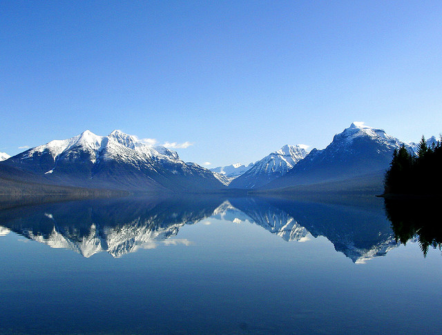
lakes in the higher areas. The park's major lakes are Lake McDonald, Two
Medicine Lake, St. Mary Lake, Lake Sherburne and the southern portion of
the transboundary Upper Waterton Lake.
The main ridge of the
Rocky Mountains separates the park into two very different zones as a
climate divide. The west is subject to the maritime influence of the
Pacific Ocean with moderate temperatures and high rainfall, while the
east side belongs to the continental climate characterized by extreme
seasonal temperature differences and the blizzards from north directions
typical of North America. In the east of the park, +47 °C were measured
at Two Medicine Lake in 1937, and south of the park at Rogers Pass in
1954 -57 °C, the lowest temperature in the United States outside of
Alaska. With this temperature range, Montana is the state with the
largest measured temperature difference. At Browning, just east of the
park, on January 23, 1916, the temperature dropped from 7 °C to -49 °C
in a 24-hour period, the greatest temperature drop in a day in the
United States.
Glacier National Park is geologically highlighted by
the Lewis Thrust. This thrust overlies very old rocks from the
Proterozoic, formed up to 1.5 billion years ago, overlying younger
strata from Quaternary and Cretaceous and the last 100 million years. In
the course of the Laramian orogeny, plate tectonic processes built up
pressure off the North American west coast. This was propagated
eastwards into the North American Plate and a tectonic cover of about
450 kilometers in length in north-south direction and a thickness of at
least 5000 meters was receded by about 80 kilometers at a shallow angle
in the period from 80 to 40 million years ago Pushed east over the rock
there. Tensions within the nappe resulted in a syncline, a concave—that
is, inward—vaulted structure that causes rock strata to lie higher in
the east and west of the park than in the center. They form the park's
two north-south mountain ranges, the Lewis range to the east and the
Livingstone range to the northwest. This particular formation raises the
Lewis range to the east, without foothills, above the Great Plains.
Erosion of the upper layers of the Lewis Thrust and valley formation
during glaciation exposed the Proterozoic rocks and sharpened their
geological profile. Over 2100 meters of elevation in eight stratigraphic
layers are exposed in the park, making the area the premier research
area for the physical and chemical composition of Proterozoic rocks and
thus the environmental conditions on Earth between 1.5 billion and 900
million years ago worldwide.
The origin of the park's older rocks
are clastic sedimentary rocks. Rocks such as sandstone, slate and
limestone were initially formed from the deposits of sand, clay and the
calcareous shells of zooplankton in a primordial sea. Parts of it have
been transformed over geological time by the pressure of later strata
into metamorphic rocks such as quartzite, slate, crystalline limestone
(marble) and dolomite. Compared to outcrops of Proterozoic rocks in
other parts of the world, the low disturbance is to be emphasized: In
the Glacier-Waterton area, details of the sedimentation such as
millimeter-precise stratification, ripple marks, imprints of salt
deposits, oolites, clay breccias and other forms have been preserved.
The younger Quaternary and Cretaceous rocks are only exposed in the east
of the park and consist of sandstone and siltstone. In between, rocks
from around 800 million years are missing, they were removed by erosion
before, during and after the formation of the mountains.
The
different layers of rock contain fossils. When the Proterozoic rocks
formed, life on Earth existed only in early forms. Stromatolites of
fossilized biofilms of cyanobacteria are preserved in all of the Park's
Precambrian rocks and are particularly common in the Siyeh Formation of
dolomite and limestone that make up the majority of the higher peaks in
the Park. Fossils of early seaweed and four species of invertebrates
also occur in the younger Precambrian strata. Fossil shells and snails
are found in the Quaternary rocks. In the Appekunny Formation in the
east of the park, which is dated to be 1.5–1.3 billion years old, casts
were found in 1982, which the discoverers interpreted as Metazoa and
were described as Horodyskia moniliformis according to new
investigations in 2002. They are among the earliest traces of
multicellular animals in the world.
The Glacier National Park as the center of the Crown
of the Continent Ecosystem is almost unaffected by modern human
intervention in the habitats and the animal and plant world. As far as
is known, since 1492, the year Christopher Columbus landed and a
reference point for natural and cultural conditions without European
influence, only three animal species have become extinct in the park:
The American bison and the pronghorn as herd animals of the prairie
formerly touched the extreme east of the park. The swift fox (Vulpes
velox) was wiped out as a predator in the 1930s. The information is
inconsistent as to whether caribou of the subspecies Rangifer tarandus
caribou (Canadian forest caribou) ever used the middle elevations of the
eastern flank. A total of over 70 species of mammals live in the area,
around 250 species of birds and over 1130 species of plants have been
identified. The park's fish fauna suffers from the fact that non-native
species were naturalized in the park from the end of the 19th century
until 1971 in order to make the area more attractive for anglers.
However, no species was completely displaced from the park by the
artificial stocking and the natural fauna is preserved in most of the
highest lakes.
Five of the park's species, bald eagle, grizzly
bear, timber wolf, Canadian lynx, and bull trout (Salvelinus
confluentus), are listed as "Vulnerable" under the Endangered Species
Act. The northern Rocky Mountain timber wolf was briefly removed from
federal protection and placed under state jurisdiction by the US Fish
and Wildlife Service in April 2009. A federal court restored the
protection in August 2010 because the delisting failed to recognize the
interconnectedness of the Rocky Mountain populations.
The exact
number of grizzly bears living in the park is not known. Park biologists
estimate the number at around 350. American black bear numbers are
significantly higher at at least 800. Black bear population estimates
vary widely: a DNA study evaluating bear hair indicates a black bear
population up to 6 times higher.
The park has different
ecosystems according to the altitude levels. About 55 percent of the
area is forested, the rest consists of grasslands in the lowlands (8
percent), bodies of water and wetlands (8 percent), and the alpine mats
and bare rock in steep faces and above the tree line (29 percent). Due
to the climatic differences between the maritime influenced west side
and the continental east flank, the transitions between the respective
ecosystems are deeper on the east side with its harsher winters.
In the east, the prairies of the Great Plains
originally reached just below the mountain flank. They have been almost
completely converted into agricultural land. In the park there are a few
small remnants on moraines, where the high grass-lawn communities merge
into loose forest communities. They consist mainly of American Aspens
and, like the prairies, depend on sporadic fires that push back species
that are less well adapted to the environmental factor of fire. Yellow
pine, Douglas fir, Coast pine and Engelmann spruce mix with the aspens.
Since fires were fought in the national park until the 1980s, the number
of yellow pines in particular has increased massively. Artificially set,
small fires in suitable times of the year are intended to restore the
original condition.
To the west, the foothills of the Palouse
range extend into the river valleys at the park boundaries. The prairies
here are denser, forming a small-scale mosaic of wetlands and hill
ranges. The tree species are the same as in the East, with Coast Pine
and Quaking Aspen favoring the wetter sites and Ponderosa Pine the drier
sites. On the banks of the river stands a gallery forest of willows and
western balsam poplar.
The prairies are habitats for animals that
are adapted to drought and intense temperature fluctuations. These
include various rodents, including the northern gopher (Thomomys
talpoides) and the Columbia ground squirrel, which live mostly
underground. Herd animals of the prairies are no longer found in Glacier
National Park. Forest edges of the lowlands are the preferred habitat
for the silver badger. The prairie hare lives only on the east side.
Coyote, wolf, and cougar are the largest predators on the prairies, but
they are also found throughout the park's ecosystems. The American black
bear comes only occasionally, the grizzly rarely in the lowlands. The
bird life is diverse and consists of residents of the reed beds by
creeks, gallinaceous birds on the prairies proper, and several species
of hawks, buzzards and the Hudson's harrier (to list more common
raptors).
Hillsbrad forest communities are found only in the south-west of the park. In sheltered valleys with high rainfall there are giant arborvitae and hemlock. Since the two species close early, the forests are poor in understory and only shade-tolerant plants such as the Pacific yew and mosses colonize the soil. After forest fires, the Western American larch grows on these sites as a pioneer species. The Great Fire of 1910 has meant that the species has been more widespread in this part of the park since then and to this day than was thought for previous centuries.
The montane forests below 1400 meters in the east and
1500 meters in the west make up the largest part of the park area. They
are dominated by the Douglas fir. Quaking aspens and balsam poplars as
well as the paper birch mix among them in dry locations and those with
only a small humus thickness. The forests are rich in flowering plants
in the herbaceous layer and pillar fungi, depending on the season.
The forested slopes of the park are the most diverse habitat. Home
to the park's smallest mammal species, the American pygmy shrew, various
squirrels including the western gray squirrel, raccoons, North American
tree quills, and the largest grouse and ruffed grouse. The snowshoe hare
lives in the deep forest zones and on the edge of the prairies. It is
the preferred prey for the Canadian lynx, with the two species having a
close predator-prey relationship and their population dynamics being
directly related. In the summer and fall, the forests are breeding and
habitat for migratory birds that would not endure the winters in the
Rocky Mountains. Among them are several tyrant species, the cedar
waxwing and the Andean treecreeper. Two nuthatch species are stick birds
and migrate only short distances in winter, depending on the weather.
Nine woodpecker species are regularly observed in the park, eight of
which breed in the area.
White-tailed deer, mule deer, elk and
elk also live in the forests of various elevations.
The tree line in Glacier National Park is at about
2000 m. The Engelmann spruce predominates in the forest stock, mixed
with the Subalpine fir. The undergrowth consists mainly of berry bushes,
including Rubus nutkanus, for example.
Open locations at this
altitude level arise in particular in avalanche zones or through very
thin layers of humus on rocky outcrops. They are shaped by bear grass,
which was chosen as the symbolic plant of Glacier National Park.
The Rock Mountain Grouse inhabits the forests of middle and higher
altitudes. The badger sparrow is particularly noticeable because it uses
exposed trees as song stations. Typical mammals are several martens,
including the fisher marten and the spruce marten, as well as little
weasels and stoats. The wolverine was almost wiped out in the park as a
detriment due to persecution; its numbers have recovered since the hunt
ended.
The following crooked wood zone extends to about 2,300
meters, at exposed locations such as the large passes only about 100
meters lower. The character tree in the northern Rocky Mountains is the
Whitebark Pine (Pinus albicaulis), along with the Subalpine Fir,
Engelmann Spruce and Flexible Pine (Pinus flexilis). Rare, but very
conspicuous in late summer and autumn, is the rocky mountain larch,
which turns its needles bright yellow relatively early.
The
grizzly comes into the deeper forests in spring, but lives predominantly
in the higher elevations of the park, both in the loose forests and
above the tree line. It feeds mainly on berries and roots, animal food
makes up only a small part of its food spectrum. The pine jay is the
characteristic bird of the crooked wood zone, it mainly feeds on the
seeds of the whitebark pine.
Above 2,300 meters there are no more trees. However,
dwarf forms of several willow species form a network that is only around
15 cm high in moist locations, which creates a microclimate and retains
heat and moisture, as well as humus and seeds. Herbaceous plants such as
heather and avens form extensive stands. Above 2,600 meters there is
only a little humus-rich soil, alpine grass communities with flowering
plants from the families of Jacob's ladders, columbines, sedum plants
and buttercups still grow here. Pure rock sites are overgrown with
lichen. There is life even in snowfields: the so-called blood snow
consists of snow algae, mainly of the genus Chlamydomonas.
The
only bird that stays at these altitudes year-round is the white-tailed
ptarmigan (Lagopus leucura). The hoary marmot and the American pika
(Ochotona princeps) as well as the mountain goat are exclusive mammals
of the alpine zone. The bighorn sheep spend the summer above the tree
lines but retreat to the woods in the winter.
22 species of fish live in the park's more than 700 lakes, streams and rivers. Of these, six were introduced by humans: Arctic char, originally found only in the northeast of the park, was introduced to waters around the park and migrated upwards into the park area so that it is now found in all of the lower lying lakes. The lakes and river corridors through the park are habitats for bald eagles and osprey. Hundreds of bald eagles congregate at Lake McDonald and McDonald Creek in the south-west of the park in the fall for the spawning season of sockeye salmon. Other types of aquatic habitats include Canadian beavers and American otters. The long-tailed weasel also lives near the water.
Originally the area was settled by Indians. Four
cultures between 10,500 and almost 8,000 years before present can be
identified from the Paleo-Indian period. The oldest finds come from the
north-east of the park on the Belly River. These are projectile tips
from the Clovis culture, around 10,500 years B.P. Still living under the
influence of the ending last ice age (called the Wisconsin glaciation in
North America), the Clovis people were hunter-gatherers, subsisting on
hunting Ice Age megafauna. A rapid climate change can be detected around
9,900 years B.P. The mountains became partially ice-free and the people
of the Lake Linnet culture were able to mine the rock argillite as
material for high-quality stone tools in the high elevations of today's
park. About 9,300 years ago the climate became drier and the first
forerunners of the prairies developed below the mountains. The
short-lived Cody culture thrived on communal hunting of bison, their
distinctive spearheads being long and narrow. Subsequent Red Rock Canyon
culture developed fishing as an essential food source in the fall when
salmon and trout migrate to the upper reaches of the rivers. The people
were very mobile and extracted high-quality chert in several places in
today's national park and hunted big game depending on the season at all
altitudes of the mountains. With her, the Paleo-Indian period came to an
end about 7,750 years ago and the Archaic period began.
It lasted
until about the year 500 and is characterized by multiple climate
changes. The Indians adapted to the environmental conditions and the
development of the animal and plant world. There were also cultural
differences between the east and west sides of the mountains. At 6,000
B.P. the Indians developed the Buffalo Jump hunting method, in which
herds of bison were driven over terrain edges and fell to their deaths.
The Head-Smashed-In Buffalo Jump, a World Heritage Site, and the First
Peoples Buffalo Jump are two major jump sites within a 60-mile radius of
Glacier National Park. After the end of the Archaic Period, pottery
spread to the northern prairies, and around 900 the bow and arrow were
introduced. The Spanish brought horses to America in the 16th century,
which spread to the northern prairies by the 17th and 18th centuries.
When they first came into contact with whites, five
peoples lived in the vicinity of what is now the national park. The
Kutenai, Flathead and Kalispel on the Flathead River to the west, the
Blackfoot Confederacy or affiliated southern Piegan on the prairies to
the east, and the Stoney, numbering only a few hundred people, in the
eastern valleys of what is now the park around the Belly River. The
peoples of the west flank migrated over the mountains to hunt buffalo in
the spring and fall on the east side, where they regularly came into
conflict with the Blackfoot. The Blackfoot and the Flathead regarded the
mountains as the "backbone of the world". They played an essential role
in their creation myths.
Two fur traders from Britain's Hudson's
Bay Company were the first Europeans to see the mountains in around 1785
and 1792. Meriwether Lewis came near the mountains on his way back from
the Lewis and Clark Expedition in 1806 and recorded in his journal the
mountain range rising abruptly from the prairie that now bears his name.
In 1810 there was evidence of whites living in today's park area for the
first time. They were hunters who supplied British and French-Canadian
fur traders. In the 1830s and early 1840s, fur trappers advanced into
the mountains of what is now the national park and decimated the beaver
population. Also, contact with the whites brought smallpox to the
prairies. The greatest infection in 1837 spread to all prairie peoples;
up to a third of the Indians died from it. In the 1850s, white mans
began to hunt bison herds on a large scale on the northern prairies.
Seeing the very basis of their diet and culture threatened, the
Blackfoot engaged in frequent skirmishes with the white invaders, and
soon became the most feared race.
In 1851 the first reservation
of the northern prairies was established, in 1855 the Blackfoot was
assigned to the area north of the Missouri River and east of the main
ridge of the Rocky Mountains. The reservations were subsequently
unilaterally reduced several times by the US government, so severely in
1872 that more than two-thirds of the Blackfoot subsequently moved to
Canada permanently.
In the meantime, wilderness had acquired a romantic
character for the upper class of the American East Coast. With the
Yosemite Grant in 1864 and the world's first national park in
Yellowstone in 1872, the United States had created the first large-scale
nature reserves that fulfilled a romantic notion of majestic landscapes.
Indian inhabitants of the landscape disturbed the impression of pristine
nature.[21] George Bird Grinnell had come to the northern prairies in
1874 as a government scientist, and when he first saw the Rocky
Mountains of northern Montana in 1885 he was fascinated by the
mountainous landscape. Now editor of Forest and Stream magazine and with
good family and personal contacts in the Washington departments, he was
an influential propagandist for the protection of the mountains.
However, he also came into close contact with the Blackfoot and was very
committed to honoring the treaties with them, the timely delivery of
food and other services.
In the late 1880s, rumors began to
spread about prolific mineral deposits in the mountains. Hundreds of
prospectors entered the reservation on their own initiative, partly
encouraged by the agents of the Bureau of Indian Affairs, who hoped
mining would also lead to economic development for the Indians on the
reservation, or who were simply corrupt. Under pressure, the Blackfoot
ceded the mountainous portion of their reservation in 1895 for a $1.5
million trust and a supply of cattle and other food. They were
guaranteed continued use of the ceded stripe as long as the area
remained "public lands of the United States". In addition to being a
food reservoir after the bison had been wiped out, the mountains had
also become important as a source of wood, since the Indians settled on
their reservations and built log houses. They also served as a sanctuary
for religious ceremonies that had been banned since the 1880s.
Grinnell was involved in negotiating the treaty as a government
representative at the request of the Blackfoot. Because of his knowledge
of the mountains, he did not believe in productive mineral finds and was
already campaigning for a nature reserve. On the west flank of the ridge
were the later founders of the U.S. Forest Service, Gifford Pinchot,
conservationist John Muir and others in the process of designating a
forest reserve. Grinnell lobbied in 1896 to protect the mountains to the
east ceded by the Blackfoot. In February 1897, President Grover
Cleveland established the Lewis and Clark Forest Reserve, which included
the entire area of what later became the national park and the areas
adjoining it to the south. Grinnell was already thinking of a national
park.
By now the area had become more accessible to visitors. As
early as 1853, a possible northern route for the transcontinental
railroad had been explored under the direction of Isaac Stevens. It was
not until the following year that the scouts found Marias Pass, which
had been recommended to them by Indians as a route across the
continental divide without major climbs. However, the route of the first
transcontinental rail line was about 500 km further south across the
Great Salt Lake. It was not until 1889 that the Great Northern Railway
re-explored a route through Montana and, beginning in 1891, extended its
route from Minneapolis/St. Paul in Minnesota in the far north of the
United States at Marias Pass across the continental divide to Seattle,
reached in 1893. The railway route was to form the southern border of
the national park when it was later placed under protection.
The
railroad company and its president James J. Hill became a collaborator
with Grinnell in the designation of the protected area. In Yellowstone
National Park, the rail connection had increased the number of visitors
tenfold in ten years and the Great Northern Railway hoped to increase
the utilization of the railway by tourists with a national park on its
route. Grinnell and Hill's lobbying was successful, and in May 1910 the
United States Congress passed the "Act Establishing 'Glacier National
Park' in the Rocky Mountains South of the International Line in the
State of Montana and for Other Purposes (36 Stat 354)" .
According to the official opinion of the US federal government, the area
ceded by the Blackfoot was already earmarked with the establishment of
the Forest Reserve, but at the latest with the national park and was
therefore no longer public land within the meaning of the 1895 treaty.
The Blackfoot, however, insisted on their rights to hunt and gather
plants in the eastern part of the park. Several trials took place until
1932, resulting in Blackfoot defeat, but the hunt continued on a small
scale. After the herd animals, popular with visitors, had been fed in
winter since the park's construction, the administration noticed
significant overgrazing in the park's valleys in the 1940s. In the
1950s, a superintendent wrote to the federal level of the National Park
Service that for several years, Indian poaching had been insufficient to
limit damage from elk herds. In the 1970s and 1980s, in connection with
the reform of United States Indian policy, the Blackfoot made claims
again. The National Park Service opposes this, but the Blackfoot
Confederation assumes that their rights under the 1895 treaty continue
de jure.
The park is the tenth national park in the United
States and was established as
“a public park or pleasuring ground
for the benefit and enjoyment of the people”
"public park or
place of amusement for the benefit and enjoyment of the populace."
Administration of the park was transferred to the US Department of
the Interior and passed to the newly formed National Park Service in
1916. The administration was tasked with providing for "the care,
protection, management and improvement to the extent necessary with the
preservation of the park in its natural state" and for "the care and
protection of the park's fish and wildlife". carry. In addition, it was
allowed to allocate land of no more than 4 hectares per site for the
construction of hotels and other accommodation for visitors, as well as
small plots of no more than 4000 m² for summer houses. However, the
Bureau of Reclamation was granted the right to dam the park's rivers for
irrigation purposes.
developments
The National Park Service
tried unsuccessfully to prevent a dam immediately east of the park
boundary: the artificial Lake Sherburne reaches about 6.5 km into the
national park. A second planned dam to enlarge the natural St. Mary Lake
was stopped by protests from the park administration and politicians.
The Great Northern Railway used the power to build hotels and built
three well-appointed hotels and two rustic chalets in different parts of
the park from 1910 to 1915. The hotels are located in easily accessible
valleys on the east and west sides. The Granite Park Chalet is in the
center of the park near Logan Pass and the Sperry Chalet is in the back
country near Avalanche Creek. Other companies built other small hotels
on the fringes inside and outside the park boundaries. For the
construction of the hotels and then for the tourists, cul-de-sacs into
the valleys and the first hiking trails were laid out at the expense of
the hotel operators. In the early years until the National Park Service
was founded in 1916, the park administration had no significant funds
available for development.
In order to enable visitors to access
the high mountains not only on foot or by horse, planning for the
Going-to-the-Sun Road began in 1917 and it was built from 1921 to 1933
for around 2.5 million dollars. The almost 85 km long connection of the
east and west sides of the park over the Logan Pass is still considered
a masterpiece of the planning engineer Frank Kittredge and the landscape
architect Thomas Chalmers Vint. The road blends into the landscape in a
previously unknown way and engineering structures were built exclusively
from the rocks of the respective section and in a rustic style.
Kittredge only re-planned the route after the start of construction in
such a way that, despite enormous additional costs, it made full use of
the Garden Wall and gained height with a slight incline, instead of
impairing the slope much more with switchbacks. But only the Logan Pass
guided tour allowed visitors to "show off the park's magnificence to the
maximum." It is designated a National Historic Landmark regardless of
park status. Several Civilian Conservation Corps camps brought
unemployed young men to the park in the following years of the Great
Depression and New Deal, where they developed campgrounds and other
tourist infrastructure as a job creation measure.
The task of
protecting and caring for the fish and wild animals of the park was
taken as an opportunity in the first decades to promote angel fish and
the popular animal species. "Beasts of prey" such as wolves, coyotes,
wolverines and pumas were pursued bitterly and almost exterminated even
in the highlands. The pursuit of predators was recognized as problematic
for the conservation goal of a national park in the 1920s, but it was
not until 1928 that targeted hunting largely ended and until the late
1930s that it was completely abandoned. The wolf was considered to be
extinct around 1930, animals only migrated from Canada to the park again
in 1979 and today form a viable population again. Also, until 1971,
popular non-native angelfish were introduced to all low-lying and some
high-mountain lakes.
Since the 1970s, about 95 percent of the
park area away from the developed areas has been managed as a de facto
wilderness area, a formal designation as a wilderness protection area
failed several times in Congress for reasons that have no impact on the
actual management.
Until the 1980s, wildfires were considered a
threat to nature, rather than an environmental factor to which
ecosystems are adapted. In 1935, a large forest fire affected 31 km²
near the east entrance of the park. In an intense debate about the value
of undisturbed natural processes, the representatives of the forestry
industry at the time prevailed and had the entire area cleared and
leveled with heavy equipment. Reasons were the fear that the damaged
forests would easily fall victim to a new fire and the unwillingness to
expect tourists in the most visited part of the park to see the traces
of a large-scale forest fire. Parts of the area were reforested, others
have since been subject to natural growth, but large areas of the area
affected at that time are largely tree-free to this day.
Since
1931, Rotarians from Montana and Alberta had campaigned for Glacier
National Park and the adjacent Waterton Lakes National Park in Canada,
which had existed since 1895, to be designated as an International Peace
Park. The governments agreed and so in 1932 the first transboundary
nature reserve was established with the intention of promoting and
celebrating peace between peoples. Since then, Rotarians from both
states and international guests have been coming together in the park on
the border every year. Both parks were independently designated as
biosphere reserves by UNESCO and jointly declared a World Heritage Site
in 1995.
Since 2002 there has been an extensive educational
program in the park under the name Crown of the Continent Research
Learning Center. The scientists of the park administration work closely
with universities and other institutions. To mark the 100th anniversary
of the founding of the national park in 2010, there has been a program
of scientific conferences, an art project and special offers for
visitors to the park and the residents of the adjacent settlement areas
since the end of 2008.
Due to the almost original condition of the park, only
a few special protection measures are required. Around 125 species of
neophytes are known and observed. In some places in the park -
especially in the valleys - they are fought with mechanical means. A
multi-year research program on the distribution of the introduced fish
species has been running since 2007, which should lead to a management
plan in which lakes active measures to restore the original fish fauna
are suitable and necessary. One of the early implementations is a fish
impermeable barrier in Quartz Creek, which will discourage non-native
fish downstream from migrating to stretches of river and lakes upstream
of the barrier that are only home to native species.
Whitebark
pine (Pinus albicaulis) has been severely restricted in vigor throughout
the Pacific Northwest and northern Rocky Mountains since the 1930's by
the rust fungus Cronartium ribicola. While 55 percent of all trees of
the species in the national park were infested in the 1990s, around 50
percent are now dead and 75 percent of the living ones are infected. In
addition, all pines, especially the yellow pine, are attacked by the
mountain pine beetle. Connections between the rapid spread of infections
and the mass infestation by the bark beetle with climate change are
considered likely. The park administration is experimenting with the
cultivation of genetically resistant specimens of the affected tree
species and reforestation with their offspring.
Forest fires play
a special role in the park's ecosystems. Every year there are smaller
fires due to natural causes, especially lightning. They are viewed by
disturbance ecology as an environmental factor that can create open
space in a previously closed forest and restart succession on
climax-stage surfaces. The plant species are adapted to periodic forest
fires and can reproduce again after a fire. Because forest fires have
been suppressed with massive interventions for several decades since the
park was placed under protection, an unusually large amount of fuel has
accumulated in the forests of the national park. After a particularly
dry spring, the summer of 2003 saw the most extensive fires in the
park's history. Around ten percent of the park area was affected, there
were large-scale fires, especially in the east of the park and in the
center of the park on the section of park road called The Loop.[38] In
the 20th century, fires of 1910 (Great Fire of 1910), 1935 and 1967 were
unusually large.
Global warming is believed to have contributed to the
particular magnitude of the 2003 wildfires. Because of its isolation
from technical influences and the existence of data for about a century,
Glacier National Park is the central research area of the American
geological survey United States Geological Survey for the program
Climate Change in Mountain Ecosystems. In particular, the extent and
other data of the glaciers in the park are collected.
The number
and size of the glaciers in the national park have decreased
significantly as a result of global glacier melt. At the end of the 19th
century there were still 150 glaciers with an area of more than 25 ha.
In 2019 there were only 25, which are also expected to melt in the
future. Scientists estimate that by 2030 the last glacier in the
national park will be gone. The extent of each glacier has been mapped
by the National Park Service and the US Geological Survey for decades.
By comparing photographs from the mid-19th century with current images,
there is much evidence that the national park's glaciers have receded
significantly since the 1850's. In 1850 there were about 150 glaciers in
what is now the Park area, and the larger glaciers now cover about a
third of the area they occupied in 1850 when they were first surveyed
and the local peak of the Little Ice Age. A large number of smaller
glaciers have completely melted. In 1993, the glaciers of the national
park covered an area of just under 27 square kilometers. In 1850 it was
about 99 km². It is considered certain that by 2030 the park's glaciers
will have melted. A reinterpretation of the data in 2009 suggested that
the glaciers would already have disappeared around 2020.
Climate
change is not only linked to the disappearance of glaciers with
consequences for the water regime of streams and lakes, it is also
expected that the boundaries of the climatic zones in the mountains will
move upwards.
In the early years, tourism in Glacier National Park
was heavily influenced by the Great Northern Railroad. It competed with
the Canadian Pacific Railway, which was developing Banff National Park
north of Alberta, Canada, and the Northern Pacific Railway, which was
developing tourism in Yellowstone National Park further south. They all
tried to get visitors into the parks to fill their rail lines. James J.
Hill, the president of the Great Northern Railroad, bet on the network
of his hotels and chalets. From 1925 there was a licensed partner of the
park administration who, with a thousand horses, brought more than
10,000 visitors a year from one of the valley hotels to the higher
elevations of the park and to one of the chalets and the next day over
the mountains to one of the other valleys - and the hotel there .
facilities
But the future of tourism development belonged to the
car. Stephen T. Mather, founding director of the National Park Service
established in 1916, advocated the development of the parks and
commissioned the Going-to-the-Sun Road. However, he also recognized that
the traffic and the buildings in the parks shouldn't destroy what the
tourists were looking for, so in 1924 he rode up into the mountains
himself to explore the route. When the road opened in 1933, his
successor, Horace Albright, put it this way: "Most of Glacier Park will
always be accessible by trails only [...] Let us not allow other roads
to compete with the Going-to-the-Sun [Road] . It should be unchallenged
and unique.”
The Going-to-the-Sun Road is now the main attraction
of Glacier National Park. About 80 percent of all park visitors drive on
the pass road. Visitors can experience the high mountains on it, at
Logan Pass there is a visitor center with an exhibition on the natural
history of the region and short and long hiking trails branch off the
road in many places. Because of the long, hard winter in the high
mountains, it is only open from early June to mid-October. From 2006 to
2012, the road was rehabilitated in sections, always remaining open to
traffic. Other roads in the park include the International Chief
Mountain Highway to Waterton Lakes National Park in Canada and several
dead-end roads to the serviced valleys on the east side.
There is
a system of shuttle buses that take hikers to and from the trails so
they don't just have to walk circular routes, and red tour buses called
"Jammers" have been operating in Glacier National Park since the 1930s.
These are still the original White Motor Company vehicles. They were
completely overhauled several times and shortly after the turn of the
millennium converted to LPG propulsion in order to become more
environmentally friendly. Tour boats and ferries operate on the park's
large lakes. Two boats from the 1920s are still in use on Swiftcurrent
Lake and Two Medicine Lake. There are over 1,100 kilometers of hiking
trails in the park, ranging from short paved trails to multi-day
wilderness tours. At the Canadian border in the park, the 5000-kilometer
long-distance hiking trail Continental Divide Trail begins, which runs
along the continental divide to the border with Mexico. Most of the
trails are also suitable for horse riders. Both short rides and
horseback riding tours lasting several days are offered. In addition,
there are some routes approved for mountain bikes.
The park's economic importance to Montana's tourism
industry is high. About 80 percent of out-of-town park visitors come to
Montana specifically for the park, and tourists who visit Montana for
the great outdoors stay longer and spend more in the state than any
other visitor.
In 2009, over two million park visitors came. They
spent most of the night outside the park. Almost 380,000 overnight stays
were counted in the park. Of these, around 130,000 stayed in the hotels
and motels, 101,000 stayed in tents on the campsites and around 106,000
in their own mobile home. The vast majority of tourists stayed on the
streets and in their immediate vicinity or made short hikes from the
valleys, visitor centers or the stops of the shuttle buses. After
registration, known as a backcountry permit, individuals and groups
spent a total of 40,855 nights in the undeveloped backcountry on
multi-day tours. Visitors concentrated on the months of July and August.
Before 2001, the border could be crossed on foot at any point if the
person entering the country immediately reported to one of several
checkpoints and met the conditions for visa-free entry into the USA or
Canada. In the aftermath of the terrorist attacks of September 11, 2001,
these opportunities were greatly reduced. The border can only be crossed
on foot at the Goat Haunt Point of Entry. A tour boat runs there on the
transboundary Upper Waterton Lake, bringing visitors from Canada to the
American side. Canadian and US citizens and permanent residents require
a passport. Citizens of other countries may take part in the boat tour,
but only leave the immediate vicinity of the pier if they have
previously entered the USA at an official border crossing and the period
of stay granted to them is still running. Otherwise, for them, the two
parts of the International Peace Park are only connected via the road
network outside the parks.