Location: Arizona Map
Tel. (928) 638- 7888
South Rim: open year round
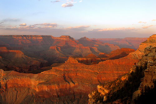
Grand Canyon National Park, located in Northern Arizona is one of the most spectacular natural formations not only in the United States, but all of the World. Grand Canyon reaches a total length of 277 miles (446 km) and a depth of 2,600 feet (800 m) carved by water and air erosion. Grand Canyon is protected by the Grand Canyon National Park services. Grand Canyon was formed by natural erosion of geologic formation by natural flow of two rivers, Colorado river and Ualpay river, over a course of millions years. Canyon cleft cut through many feet of geologic formation that was laid over millennia. Grand Canyon National Park protects almost five thousands square kilometers. The most visited area is the southern edge of the Grand Canyon that contains most popular sightseeing points. The best way to get the scale of the this magnificent canyon is by taking a helicopter tour. In 2007 fully transparent bridge was opened to the public. It hangs over a 1220 meter chasm, offering a breathtaking view below.
Spanish exploration
Grand Canyon was visited by
the expedition of Francisco Vázquez de Coronado. The first European
to see the Grand Canyon of the Colorado was García López de
Cárdenas, who commanded a handful of men from the indigenous
population that the Spaniards called Quivira, a town inhabited by
the Zuñi Indians and supposedly one of the seven cities of gold of
the kingdom of Cíbola. This town of which at the moment its location
is ignored since the historians differ on it exact location; some
place Quivira in New Mexico, while others think he was in Kansas. It
should not be confused with a city located in New Mexico that
Spanish expeditionaries called, around the year 1600, Pueblo de las
Humanas and later it was known as Gran Quivira. After 20 days of
exploratory trip they found the Grand Canyon of the Colorado.
However, they could not go down to the river to get water, and after
several attempts to descend they started having water problems to
drink, so they decided to return.
The first European to touch
and navigate the waters of the Colorado River, but hundreds of
kilometers from the Grand Canyon, would be Fernando de Alarcón (who
participated in the exploration trip but by sea). Who discovered the
Colorado River was Francisco de Ulloa on September 28, 1539, taking
a hold in the the mouth of the river (he named it Ancon de San
Andres), for the benefit of the Spanish Crown.
American
exploration
The first scientific expedition was led by the
commander of the United States Army John Wesley Powell in 1869.
Powell referred to the sedimentary rock found in the Canyon as "a
great history book."
All private vehicles entering the Grand Canyon
must pay a $30 entrance fee, which is good for seven days.
Individuals on foot or on a bike must pay a $12 entrance fee, also
good for seven days.
There are several passes for groups
traveling together in a private vehicle or individuals on foot or on
bike. These passes provide free entry at national parks and national
wildlife refuges, and also cover standard amenity fees at national
forests and grasslands, and at lands managed by the Bureau of Land
Management and Bureau of Reclamation. These passes are valid at all
national parks including Grand Canyon:
The $80 Annual Pass
(valid for twelve months from date of issue) can be purchased by
anyone. Military personnel can obtain a free annual pass in person
at a federal recreation site by showing a Common Access Card (CAC)
or Military ID.
U.S. citizens or permanent residents age 62 or
over can obtain a Senior Pass (valid for the life of the holder) in
person at a federal recreation site for $80, or through the mail for
$90; applicants must provide documentation of citizenship and age.
This pass also provides a fifty percent discount on some park
amenities. Seniors can also obtain a $20 annual pass.
U.S.
citizens or permanent residents with permanent disabilities can
obtain an Access Pass (valid for the life of the holder) in person
at a federal recreation site at no charge, or through the mail for
$10; applicants must provide documentation of citizenship and
permanent disability. This pass also provides a fifty percent
discount on some park amenities.
Individuals who have volunteered
250 or more hours with federal agencies that participate in the
Interagency Pass Program can receive a free Volunteer Pass.
4th
graders can receive an Annual 4th Grade Pass that allows free entry
for the duration of the 4th grade school year (September-August) to
the bearer and any accompanying passengers in a private
non-commercial vehicle. Registration at the Every Kid in a Park
website is required.
In 2018 the National Park Service will offer
four days on which entry is free for all national parks: January 15
(Martin Luther King Jr. Day), April 21 (1st Day of NPS Week),
September 22 (National Public Lands Day), and November 11 (Veterans
Day weekend).
The Grand Canyon stretches northeast-west in northern Arizona. It
separates the northwest of the state, the so-called Arizona Strip, from
the rest of Arizona. There are no bridges over the actual Grand Canyon,
the south and north banks of the Colorado are connected by roads only
east of the national park at Lees Ferry and Page or about 400 km further
west across Nevada at the Hoover Dam. The South Rim is accessible from
Flagstaff, the North Rim and the Arizona Strip are sparsely populated,
with the closest city being St. George in neighboring Utah.
The
Grand Canyon is about 450 km long (of which 350 km are within the
national park), between 6 and 30 km wide and up to 1800 m deep. The name
Grand Canyon for "great" or "great" was coined in 1869 by John Wesley
Powell. Various designations were in circulation beforehand.
The
area around the valley is divided into three regions: the South Rim,
which attracts the most visitors, the North Rim, which is about 300 m
higher and cooler on average, and the Inner Canyon. The South Rim of the
Grand Canyon averages 2100 m above sea level. M., while the Colorado
averages 750 m above sea level.
Upstream, in southern Utah, lie
other major canyons of the Colorado. Glen Canyon, which has been
submerged in Lake Powell's reservoir since 1964, was considered
particularly scenic. Further northeast is Canyonlands National Park.
Downriver, near Las Vegas, is Lake Mead reservoir at Hoover Dam.
Settlement by Indians
Already more than 3000 years ago people
lived in the area of the Grand Canyon. The Native Americans, known as
the Desert Culture, were hunter-gatherers who could make baskets and
sandals and hunted with stone spearheads.
About 2000 years ago,
the peoples known as Anasazi settled the area. They lived in mud huts
and built their dwellings into the walls of the ravine. They lived from
agriculture and left many petroglyphs. In the 12th century, a drought
period lasting about 3 centuries began and the Anasazi left their
homeland.
Also part of the Pueblo culture, the Hopi are their
descendants and, like other Native American tribes, lived in the area
more recently. Some Havasupai Indians still live in the canyon today.
Exploration by Spaniards and Americans
The Grand Canyon was first
sighted by a European, García López de Cárdenas of Spain, on behalf of
the conqueror Francisco Vásquez de Coronado in search of the legendary
Seven Cities of Cibola. He arrived at the southern rim of the gorge in
September 1540 with a group of Spanish soldiers and Hopi Indian guides.
Three soldiers climbed into the gorge, but turned back about a third of
the way due to lack of water. The Grand Canyon was classified as
worthless and has not been visited by any European for over 200 years.
In 1776, while exploring southern Utah, two Spanish priests passed
along the north rim of the canyon. They were looking for a way to get
from Santa Fe, New Mexico to California.
In the 1850s, Mormon
Brigham Young sent the first settlers to the area with the goal of
finding an easy way to cross the river. After the settlers established
good relations with the local Indians, two places to cross the river
were discovered, Lee's Ferry and Pierce Ferry.
The scientific
expedition of the one-armed John Wesley Powell, who left Green River,
Wyoming on May 24, 1869 with nine men and four wooden boats, became
famous. After 1500 km and through numerous dangerous rapids in the Green
River and the Colorado River, the expedition finally reached the Virgin
River, the terminus of the Grand Canyon, on August 30th. Two years
later, Powell repeated the trip and produced accurate maps and
reports.[1] He also gave the canyon its current name.
creation of
the national park
Beginning in the 1880s, the Grand Canyon was
discovered and developed as a tourist destination. In 1901 he received a
direct railway connection.
→ Main article: Grand Canyon Railway
On January 11, 1908, the area around the Grand Canyon was declared a
national monument by US President Theodore Roosevelt, who had often
stayed in the area, before it was placed under protection as a national
park on February 26, 1919. The establishment of the park is considered
an early success of the conservation movement. The whole park is about
4900 km² since its last expansion in 1975.
In 1979 the Grand
Canyon was inscribed on the UNESCO World Heritage List.
plane
crash
On June 30, 1956, two airliners collided and crashed near an
estuary in the national park. All occupants died. Many remains have been
recovered. The area is closed to hikers.
Most geologists agree that the drainage basin of what is now the
Colorado River (which includes the Grand Canyon) formed 40 million years
ago. The Grand Canyon itself is most likely not much older than five to
six million years, with most of the deep erosion occurring in the last
two million years. The result of this erosion is the insight into one of
the most complete sequences of layers on our planet.
The sequence
ranges from the metamorphic basement (the oldest dating is currently
1.840 billion years before present for the Elves Chasm Granite) in the
deepest part of the Inner Gorge to the 230 million year old Kaibab
Limestone at the canyon rim. The polymetamorphic basement is
unconformably overlain by non-metamorphic Proterozoic sediments. These
were later tilted and then discordantly transgressed in the Cambrian
about 0.5 billion years ago by a Paleozoic layer sequence. Therefore,
there is no continuous sequence of strata, but two significant (and
several smaller) strata gaps.
Many of the rock formations were
deposited either in warm shallow seas, near shore (beach area) or in
swamps, synchronous with the shoreline oscillating several times across
the continental margin of Proto-North America. Exceptions are the
Coconino Sandstone, which many geologists interpret as desert sand
dunes, and parts of the Supai Group.
The great depth of the Grand
Canyon (about 1600 meters) and the overall thickness of its strata (most
layers were deposited below sea level) suggest an uplift of the Colorado
Plateau by 1500 to 3000 meters. This uplift process took place in the
course of the Laramic orogeny, which began about 65 to 70 million years
ago and gave rise to the Rocky Mountains.
Due to the newly
created barrier, the Colorado could no longer flow in its original
direction to the southeast. So he dug a new bed across the nascent
Colorado Plateau. The river was now getting the melt water of the Rocky
Mountains and in addition to the higher gradient it had much more
erosive power to start carving out the Grand Canyon. The Colorado now
flowed through fault zones in the rock that had been created by the
uplift of the Colorado Plateau. There he eroded the rock faster because
it was shattered and shifted into each other. Over millions of years,
the Colorado dug deeper and deeper into the rock. Today he is working on
very hard and old (1.8 to 1.4 billion years) basement granites. Because
these rocks are difficult to erode, the Colorado tends to erode softer
layers at the edges (selective erosion). As a result, today the gorge is
growing more in width than in depth.
With the opening of the Gulf
of California approximately 5.3 million years ago, the erosion base of
the Colorado (or its progenitor) was drastically lowered, causing an
enormous increase in its erosive power. In the upper reaches, other
river systems were tapped. As a result, it had almost reached its
current level 1.2 million years ago.
During the ice ages, there
was much more precipitation in the catchment area of the Ur-Colorado,
which increased the speed at which the river cut into the depths.
Even the volcanic activity that began a million years ago on the
western edge of the national park (Uinkaret Volcanic Field), whose ash
and lava once blocked the canyon, could not withstand the forces of the
river in the long term. This spot is still easily recognizable by the
different color scheme.
In the Grand Canyon, temperatures are regularly below zero from
November to March; from May to September, the temperature regularly
rises above 20 °C during the day; July is the warmest month with an
average temperature of 29 °C (daily high), while January is the coldest
month with an average temperature of −8 °C (daily low). It should be
noted that it is much hotter in the gorge than at the edges, especially
in summer. On average, it rains considerably more on the northern rim
than on the southern rim. On average, up to 5 m of snow falls annually
on the northern edge, and about 1.5 m of snow falls on the southern
edge. On the other hand, snow rarely falls at the level of the Colorado
(less than 2 cm on an annual average). The annual precipitation total on
the northern edge is about 700 mm/year, but only 380 mm per year on the
southern edge. At the level of the Colorado in the gorge, about 180 mm
of rain falls per year.
These values (rain and climate) are
average values.
The diversity of the Grand Canyon results from the differences in
altitude and climate in the canyon and its rims, which include five
vegetation zones: the river and riparian zones, a desert strip in the
inner canyon, the plateau zone with juniper and pinyon pine shrubs, the
South edge and corresponding zones on the north side characterized by
the yellow pine and the highest north edge with a spruce-fir forest.
Depending on the exposure and inclination of the slopes, a mosaic of
small-scale habitats with adapted vegetation and the corresponding fauna
results. So far around 1500 plant, 355 bird, 89 mammal, 47 reptile, 9
amphibian and 17 fish species have been identified. There are also
several thousand insect and arachnid species and other invertebrates.
Coniferous forest grows at the highest point of the Grand Canyon at
an altitude of 2683 m, while mixed forest already exists at the rim of
the canyon. Below 1500 m (in the gorge) cacti and shrubs grow, but no
more trees. Right on the Colorado there are oases where there are grassy
areas. The rest of the river is desert. There are more than 1,500
different plant species in and around the Grand Canyon, 11 of which are
endangered.
Along the Colorado River itself are big cats such as
cougars and bobcats, as well as other predators such as cat frets, gray
foxes, and coyotes. Other canyon mammals include bighorn sheep and
numerous small rodents. Mule deer come to the river during dry seasons.
Herons, rainbow trout and frogs live in the oases. Those responsible are
particularly proud of the successful resettlement of the California
condor, which was almost extinct in 1987. The otters appear to have
disappeared in recent years, while the beaver population appears to have
increased. In the remaining parts of the national park, the wider area
surrounding the canyon, live 300 different species of birds and 76
species of mammals. In addition to the species already mentioned, black
bears, elk and collared peccaries can also be found here.
The
river's ecosystem itself has been largely cut off from previous periodic
flooding since the construction of Glen Canyon Dam in 1963. In order to
promote the relocation of debris, the formation of sandbanks and the
creation of free sand, gravel and stone surfaces, there were experiments
with targeted flooding of the canyon by opening the dam gates in 1996,
2004, 2008 and in November 2012 The flooding is intended to improve the
living conditions of the Gila cypha (humpback chub), an endangered
carp-like fish that has been extinct in the actual Colorado River since
the construction of the dam and is only found in the Little Colorado
River tributary. Environmentalists at the Grand Canyon Trust see the
benefit of the measure as proven and call for regular flooding instead
of irregular experiments. In 2009, humpback chubs were settled in
another tributary of the Colorado River within the national park.
early history
There is a consensus among scientists that the early
settlement of the American continent began at the end of the last ice
age (Pleistocene), ie around 12,000 to 7,000 years ago. The southern
edge of the ice sheet at that time roughly coincided with the
present-day Canada–United States border. The immediately adjacent area
was tundra and then gave way to an extensive forest area. The first
immigrants apparently encountered a species-rich animal world in the
late Pleistocene. However, when exactly the first people came to North
America across the Bering Strait, then a land bridge, is one of the
great archaeological disputes.
Scientists indicate the time
between 7000 B.C. to the lifetime of Christ as the Period of the Desert
Culture or Desert Cultures. Already at this time people lived in the
area of the Grand Canyon. The members of this hunter-gatherer culture
had inhabited the steppes and deserts of northern Mexico and the
south-west of the USA. The subsistence of these peoples, who could make
baskets and sandals and hunted with stone spearheads, was small animal
hunting and the intensive search for edible plants, wild grain, tubers
and berries. They built permanent pit houses, round or square burrows,
covered with twigs and mud and called pithouses.
Between 1200 BC
to about 400 AD the Basketmakers lived in the region. The name refers to
the typical beaded wickerwork that has survived well in the arid climate
of the Southwest. They are a precursor to the Anasazi culture with sites
on the southern Colorado Plateau.
Anasazi
Until about 700 BC
the culture of the Anasazi can be traced back. Native to the Colorado
Plateau in what is now Arizona, Utah, Colorado, and New Mexico, the
Anasazi were initially hunter-gatherers, but later subsisted partly by
growing corn and beans and raising turkeys. They first lived in pit
houses and then in pueblos built of unbaked clay (Adobe). The pit houses
were developed into places of worship, the kivas, which, like the
abandoned pueblos, can be found in numerous places in the Southwest.
Many of the Anasazi settlements have survived sheltered from the dry
desert air, while others have been restored.
In the 14th and 15th
centuries there were extensive population movements, the reasons for
which cannot be fully explained to this day. From 1276 there was an
exceptional drought on the Colorado Plateau; For almost a quarter of a
century scarcely a drop of rain fell. This probably forced the Anasazi
to abandon their settlements. They moved to the Hopi Mesas of northern
Arizona, the Zuni River, and the Rio Grande. Today's Hopi and the Pueblo
Indians are considered descendants of this people.
Modern Indian
cultures
After the Anasazi left the Grand Canyon area,
Athabaskan-speaking nomads, the Apache and Navajo, appeared from the
north, while from the south and west the Yuma, Zuñi, and Hopi settled in
their traditional tribal lands. The rich oral tradition of most tribes
about this period is preceded by detailed legends of origin and
migration. Tribes in the Grand Canyon area include the Walapai,
Havasupai, Hopi, Navajo, and Kaibab.
walapai
The Walapai or
Hualapai are a Yuman-speaking tribe of the Hokan language family and
their traditional tribal territory stretched from the Bill Williams
River south to the Grand Canyon north and west to the Colorado River.
The Walapai were a small tribe whose total population did not exceed a
thousand. Their tiny settlements usually consisted of two or three
families and could be found anywhere on the arid plateau where a steady
supply of water could be found. The Walapai engaged in some farming but
subsisted mostly on game and edible wild plants. Today, cattle herding
is their main livelihood and the tribal income comes from timber sales.
Due to limited natural resources, most walapai have to leave the
reserves to earn a living. The 2000 census recorded 1,353 walapai, of
whom 425 were permanent residents of the Hualapai Reservation. The
Walapi operate the Grand Canyon West amusement park outside of the
national park. It is also home to the Grand Canyon Skywalk, which opened
in Spring 2007 and allows visitors to stand 4,000 feet above the Grand
Canyon floor on a horseshoe-shaped steel bridge with a glass floor and
railings.
Havasupai
The Havasupai also speak Yuman like their
western neighbors, the Walapai, from whom they separated in the 12th
century. To seek protection from possible attackers, they moved to the
floor of the Grand Canyon. Even today they are the most isolated Native
American tribe in the United States. Their Havasu Canyon reserve is
accessible only by foot or horseback via two long trails descending from
the canyon rim. The Havasupai used to inhabit the canyon floor only
during the spring and summer months to tend their tiny gardens. After
the fall harvest, they moved to their winter quarters on the plateau,
where they hunted deer, antelope, and mountain sheep. In the winter
months, the river valley turned cold and misty because the steep canyon
walls kept out the sunshine. The cremation of the dead followed by
destruction of their personal belongings, one of several Yuma rituals,
was practiced until 1895, when the Bureau of Indian Affairs outlawed
this "uncivilized" practice. The 2000 US census counted 634 members, of
whom 404 still spoke the traditional tribal language.
hopi
The
Hopi are the westernmost group of Pueblo Indians and now live in
northeastern Arizona on a 12,635 km² reservation that is an enclave of
the much larger Navajo reservation. They live in villages perched on
mesas rising from the Colorado Plateau and speak a Shoshone dialect from
the Uto-Aztec language family. The Hopi used to farm and raise sheep.
Corn was the primary crop, but they also planted beans, squash, melons,
and a variety of other vegetables and fruits. They are known to be a
deeply religious people, and boys and girls began their ceremonial
career soon after the age of six with initiation into the cult of
kachina. Hopi-kachinas were masked imitations of a large number of gods
and spirits, as well as deceased ancestors, portrayed by men. The most
famous of all Hopi rituals is the snake dance, performed at the end of
August, in which the performers dance with live snakes in their mouths.
In fact, viewers only see a brief but exciting snippet of a longer
ceremony, most of which is celebrated in secret at Kivas.
The
Hopi reservation has been under severe threat since the 1960s due to
large white corporations claiming the mineral resources there. However,
the Hopi have so far been able to resist this pressure, also through
very good public relations.
Navajo
The Navajo, also Diné in
their own language, are the largest of all Native American peoples in
the United States with 338,443 members (according to the 2005 census)
and live mostly on the 69,650 km² largest reservation in northern
Arizona and New Mexico. The Navajo, like the Apache, speak an Athabaskan
language. The once nomadic people have been heavily influenced over the
centuries by the neighboring Pueblo Indians, with the result that
agriculture has become the main basis of their subsistence. But the
region is mostly dry and generally did not allow enough agriculture and
animal husbandry to secure a livelihood for everyone. Thousands,
therefore, earn their living as laborers off Navajo land, and a
significant number have settled on irrigated lands along the Colorado
River and in such places as Los Angeles and Kansas City.
The
Navajo religious system is diverse. The complex rites require a
specialist who is paid according to his skill and the length of the
ceremonies. Most rites are primarily staged to heal physical or mental
illnesses. Other ceremonies involve simple prayers and chanting, and dry
painting of pollen and flower petals. In some cases, there are public
dances and performances that gather hundreds or thousands of Navajo and
visitors.
The Navajo regularly raided neighboring tribes and
white settlers, though never on the scale of their warlike Apache
relatives. They were considered dangerous enough that Colonel Kit Carson
finally received the order to subdue them in 1863. More than 8,000 Diné
were taken into captivity at Bosque Redondo in southern New Mexico in
1864 on the 300-mile (480 km) march.
Kaibab
The Kaibab are a
branch of the Southern Paiute people who belong to the Uto-Aztec
language family and lived along the North Rim of the Grand Canyon in
northwestern Arizona, southern Utah and southeastern Nevada. The
Kaibab's livelihood was gathering food. They led a semi-nomadic life to
get to the most productive places where the wild plants grew. Their
copious consumption of edible roots earned them the scornful nickname
"Diggers" from white people, but even the most haughty Americans had to
acknowledge that the Paiute could exist in a country where a white man
would starve to death very quickly. Nothing edible went unnoticed: pine
seed, wild grass seed, even locusts and caterpillars. There was hardly
any large game, so the Indians had to catch rabbits, birds, prairie dogs
and mice. The Kaibab Reservation was established in 1917. The land is
only suitable for livestock although some gardens are tilled. These
Indians earn their living with a tribe's own herd and wage labour. The
2000 census showed 196 tribesmen living on the 487 km² reservation.
Various activities are available at or in the Grand Canyon. A
sightseeing flight from the small airport on the southern edge or from
Las Vegas offers a good "overview".
vantage points
A common
activity is heading to the various viewpoints, exploring a bit or two of
the canyon rim on foot. For this purpose, the rim of the Grand Canyon
will be opened up by roads mainly in two areas, in the vicinity of the
"Grand Canyon Village" on the south rim and in the vicinity of "Bright
Angel Point" on the north rim, where the local information center is
located. On the South Rim, an 7-mile (11 km) stretch of the rim from
Grand Canyon Village west to Hermits Rest is accessible only by shuttle
buses ("West Rim Drive"). The main road from Grand Canyon Village, which
is accessible to automobiles, follows the course of the canyon ("East
Rim Drive") for 42 km in an easterly direction to the "Desert View"
lookout point.
Bright Angel Point is accessible on the northern
edge, with good views of the side canyons already occurring at the
driveway. The road from "Point Imperial" to "Cape Royal" follows the
canyon rim for 29 km. This southernmost vantage point on the North Rim
includes the stone arch of the Angels Window. This rock formation was
created by weather influences. Rain, accumulation of water, ice, wind,
etc. eroded the transition to the viewpoint, creating a window.
In addition, individual points on the canyon can be reached via gravel
roads, in particular the "Point Sublime" on the northern rim, a point on
the southern rim in the Havasupai Reservation, from which the Indian
settlement of Supai in the canyon itself can be reached on foot, by mule
or by helicopter and a point on the Hualapai Reservation, also on the
South Rim, where the Grand Canyon Skywalk opened in 2007.
Large
distances have to be covered in order to gain as many different
impressions of the canyon as possible. The walk from Grand Canyon
Village on the South Rim to Bright Angel Point on the North Rim is 34
km, but it is 354 km by vehicle as there is no bridge over the canyon.
The Skywalk is 390 km from Grand Canyon Village.
hikes
For
more athletic people, there is a hike into the canyon or in the canyon.
A permit is required for overnight stays within the Grand Canyon. It can
be requested at the earliest four months before the planned date. The
number of permits is limited. Strict rules apply to such tours,
compliance with which is monitored by the park rangers. Day trips, on
the other hand, are possible without a permit.
There are a large
number of trails in the canyon: the most famous (and busiest) are the
South Kaibab Trail and the Bright Angel Trail from the South Rim to the
river, and the North Kaibab Trail from the North Rim along Bright Angel
Creek to the river.
Hikes from one of the edges of the valley to
the river lead over 1400 meters in altitude, through five climatic zones
and about 1.7 billion years of geological history. In summer, even with
moderate temperatures at the canyon rim, there can be considerable heat
inside the gorge. Overconfidence or inadequate equipment on the part of
some hikers result in complicated rescue operations and even fatalities
year after year. Drinking water is only available on the North Kaibab
Trail and Bright Angel Trail. Some companies offer trail rides through
the gorges of the Grand Canyon on horseback or mule.
boat tours
Boat trips offer an extensive view from the river. Because the river is
accessible in only a few places, within a day or two, either the
northeastern portion upstream of Lee's Ferry or the western portion
between Diamond Creek (on the Hualapai Reservation) and the confluence
with Lake Mead (especially South -Cove exit). A drive from Lee's Ferry
to Diamond Creek through the central part of the Grand Canyon (364 km or
226 miles) takes three or more days. Also common are descents, during
which stops are made for smaller hikes and/or climbs and for which more
time is estimated.
Boat tours are primarily undertaken for the
views and fame of the Grand Canyon. The Colorado also offers white
water, but there are long stretches of calm water in between. For the
most commonly paddled stretch of river from Lee's Ferry to Diamond Creek
(364 km), American Whitewater lists only 31 named rapids of II+ to IV+
on the VI-level whitewater difficulty scale; the often added next 83 km
(59 miles) is followed by only two more named rapids (as of January
2010).
On the other hand, the Colorado owes its widespread
reputation as an extremely difficult river for rafting or whitewater
canoeing mainly to the past: For one thing, its power was actually
greater before it was regulated by the Hoover and Glen Canyon Dams. On
the other hand, whitewater sports have developed significantly over the
last 100 years; With modern whitewater canoes, modern paddling
technology - including the Eskimo roller - and last but not least modern
safety equipment (helmets and life jackets), the rapids of the Colorado,
which were still awe-inspiring at the time of Powell's expeditions, are
nothing unusual for experienced whitewater athletes. The challenge of
the river today is its still impressive water volume (volume flow) and
above all its relative isolation, which is why heavy luggage is taken
for several days, which makes the boats less manoeuvrable. However,
kayakers often travel with escort rafts on which gear and food are
loaded. This makes it possible to navigate even with small toy boats,
which would not offer enough space or buoyancy for the necessary
luggage.
The regulation of the Colorado by the construction of the Glen Canyon Dam and many low-rainfall years since 2000 have led to a significant reduction in the amount of water. This has resulted in wide beaches, which, however, do not correspond to the natural ecosystem of the canyon and therefore have a negative impact on the living environment. The canyon has already been flooded several times to minimize the consequences of anthropogenic interference.