Location: Alamosa and Saguache counties, CO Map
Area: 84,670 acres (342.6 km2)
Official site
Great Sand Dunes National Park is situated in Alamosa and Saguache counties, Colorado in United States. Great Sand Dunes National Park covers an area of 84,670 acres (342.6 km2) that were left from sand and salt deposits. Originally designated Great Sand Dunes National Monument, the Great Sand Dunes National Park and Reserve was created by an act of the United States Congress on September 13, 2004.
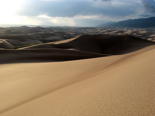
Great Sand Dunes National Park contains the
highest sand dunes in North America that rise to a maximum height of
230 meters from the floor of the San Luis Valley, at the western
base of the Sierra de la Sangre de Cristo. This group of dunes
covers about 77 km² and according to the researchers began to form
less than 440,000 years ago.
The dunes are created from the
sand and sediment deposits of the Rio Grande and its tributaries
that flow through the San Luis Valley. With the passing of the
years, winds from the west collect the sand particles from the lands
flooded by the river. When the wind loses its strength before
crossing the Sierra de la Sangre de Cristo, it deposits the sand at
the eastern end of the valley. This process continues and the dunes
grow slowly as the wind molds them again each day.
There are
several streams that flow through the perimeter of the dunes. These
streams erode the edge of the dune field and carry the sand
downstream until the water seeps into the earth, disappears and
deposits the sand on the surface. The wind lifts the sand deposits
and blows them again over the field of dunes. Just dig a few inches
even at the top of the dunes to discover wet sand. Part of the
motivation to convert the national monument into a Great Sand Dunes
National Park was to increase protection over water, desired both by
the cities of Colorado and by the farmers in the area.
It is
very easy to experience the process of dune formation. It is a very
windy region, as can be seen by the walkers who visit it since many
days are riddled by sand and even by small stones when they walk on
the dunes. These materials are transported by the wind kilometers
away and although the dunes do not change place or size very often,
there are parabolic dunes that migrate through the main dune field.
Sometimes they join this and other times they are covered by grass
and vegetation and stay where they are.
The dunes are
relatively stable but their morphology changes slightly with the
passing of the seasons because their shape is affected with
intensity by the direction of the wind. The wind normally goes from
the South-West to the North-East but at the end of summer the wind
turns around creating remontary dunes. This process is part of the
reasons that make the dunes so high.
There are areas of black
sand in the dunes that are actually deposits of magnetite, a black
and crystalline iron oxide.
The entry fee is $20 for each non-commercial
vehicle, which includes all occupants. A motorcycle and riders entry
fee is $15 total. Oversized vehicles with 15 or more passengers are
charged at $10 per person for each person age 16 or older. All fees
are for 7-day passes, which allow unlimited re-entry for the week.
The Great Sand Dunes Annual Pass also allows free access to the park
for one year and costs $40.
There are several passes for
groups traveling together in a private vehicle or individuals on
foot or on bike. These passes provide free entry at national parks
and national wildlife refuges, and also cover standard amenity fees
at national forests and grasslands, and at lands managed by the
Bureau of Land Management and Bureau of Reclamation. These passes
are valid at all national parks including Great Sand Dunes National
Park:
The $80 Annual Pass (valid for twelve months from date
of issue) can be purchased by anyone. Military personnel can obtain
a free annual pass in person at a federal recreation site by showing
a Common Access Card (CAC) or Military ID.
U.S. citizens or
permanent residents age 62 or over can obtain a Senior Pass (valid
for the life of the holder) in person at a federal recreation site
for $80, or through the mail for $90; applicants must provide
documentation of citizenship and age. This pass also provides a
fifty percent discount on some park amenities. Seniors can also
obtain a $20 annual pass.
U.S. citizens or permanent residents
with permanent disabilities can obtain an Access Pass (valid for the
life of the holder) in person at a federal recreation site at no
charge, or through the mail for $10; applicants must provide
documentation of citizenship and permanent disability. This pass
also provides a fifty percent discount on some park amenities.
Individuals who have volunteered 250 or more hours with federal
agencies that participate in the Interagency Pass Program can
receive a free Volunteer Pass.
4th graders can receive an Annual
4th Grade Pass that allows free entry for the duration of the 4th
grade school year (September-August) to the bearer and any
accompanying passengers in a private non-commercial vehicle.
Registration at the Every Kid in a Park website is required.
In
2018 the National Park Service will offer four days on which entry
is free for all national parks: January 15 (Martin Luther King Jr.
Day), April 21 (1st Day of NPS Week), September 22 (National Public
Lands Day), and November 11 (Veterans Day weekend).
The park contains the tallest sand dunes in North America rising to a
maximum height of 230m. from the floor of the San Luis Valley, at the
western base of the Sierra de la Sangre de Cristo. This group of dunes
covers about 77 km² and according to the researchers began to form less
than 440,000 years ago.
The dunes are created from the sand and
sediment deposits of the Rio Grande and its tributaries that flow
through the San Luis Valley. Over the years, westerly winds collect sand
particles from the land flooded by the river. When the wind loses
strength before crossing the Sierra de la Sangre de Cristo, it deposits
the sand at the eastern end of the valley. This process continues and
the dunes slowly grow as the wind shapes them anew each day.
There are several streams that flow around the perimeter of the dunes.
These streams erode the edge of the dune field and carry the sand
downstream until the water seeps into the land, disappears, and deposits
the sand on the surface. The wind picks up the sand deposits and blows
them back over the dune field.
It is enough to dig a few
centimeters even at the top of the dunes to discover wet sand. Part of
the motivation for turning the national monument into a national park
was increased protection over the water, desired by both Colorado cities
and area farmers.
It is very easy to experience the formation
process of the dunes. It is a very windy region, as visiting hikers can
attest, as many days they are riddled with sand and even small stones
when walking on the dunes. These materials are carried by the wind for
kilometers away and although the dunes do not change location or size
very often, there are parabolic dunes that migrate through the main dune
field. Sometimes they join it and other times they get covered by grass
and vegetation and stay where they are.
The dunes are relatively
stable but their morphology changes slightly with the passing of the
seasons because their shape is strongly affected by the direction of the
wind. The wind is normally from the SW to the NE but at the end of
summer the wind turns around creating rising dunes. This process is part
of the reasons that make the dunes so high.
There are areas of
black sand in the dunes that are actually deposits of magnetite, a
black, crystalline oxide of iron.
The Great Dunes are situated on a large area of "high desert" land (typical of the American Southwest) in the San Luis Valley, just on the west side of the Sierra de la Sangre de Cristo. Summer temperatures in the area are not typical of normal high desert lands although the large difference between high and low temperatures remains. During winter nights, low temperatures can be extremely cold and many nights during winter temperatures are below zero. In parts of the desert far from the dunes, precipitation is extremely low, but even in the area of large dunes it remains low, averaging 280 mm. year. The high levels of evaporation mean that they are considered a desert despite the fact that their rainfall exceeds 250 mm. and it even snows on the dunes, though the snow (which can accumulate up to 8 inches between late winter and early spring) is very short-lived in Colorado's dry, sunny climate.
The park also contains montane lakes and high montane tundra, six
peaks above 12,000 ft, old-growth spruce and pine forests, large tracts
of aspen and cottonwood, grasslands, wetlands, etc. All these
environments are home to various species of flora and fauna.
One
of the more unusual features of the park takes place at Médano Creek,
which runs along the east side of the dunes and is located near the
bookstore and visitor center. Due to the fact that the sand continually
falls on the water, the Médano Creek never finds a stable and permanent
channel. Small underwater dunes that act as dams are continually being
formed and destroyed, so waders witness rises (which can look like
waves) in the level of the water flowing downstream at intervals ranging
from a few seconds to a minute or more. In a year with a lot of rain,
these elevations can reach a foot high, resembling waves in the open
sea. Building sandcastles from the sand from the creek is a popular
activity with visitors and skimboarding is becoming more popular thanks
to the fact that very little water is needed to carry it out.
One
of the most valued characteristics of the Great Dunes National Park and
Reserve is one that cannot be seen and that is that according to a
soundscape study carried out by the National Park Service under the name
of Natural Sounds Program, this park is the most silent of the 48
contiguous states of the country.
Many visitors to the area carry
flattened cardboard boxes or boogie boards to the top of the dunes with
the intention of sliding down; however neither of the two objects have
turned out to be effective for sliding. Visitors going at times other
than winter are also advised to avoid going barefoot or wearing sandals
and stick to sturdy, closed-toe shoes. This is because while sand is
attractive, its dark color absorbs heat. Sand temperatures in daylight
can well exceed 40 degrees and burn exposed skin quickly.
To get to the dunes you have to cross the wide and shallow Médano
Creek, which runs only from spring to early summer. Hiking is allowed,
with the warning that the sand can be hot in summer, up to 60º Celsius.
Snow falls in winter on the area.
The closest city is Alamosa
although Cañon City, Pueblo, Colorado Springs, Denver and Albuquerque
(New Mexico) are just a few hours away by car. The United States Postal
Service in Alamosa (ZIP Code 81101) is in charge of serving the park.
park history
The dunes and the area surrounding them were
designated a national monument in 1932. On November 22, 2000, Bill
Clinton, President of the United States, signed the Great Sand Dunes
National Park and Preserve Act of 2000 with the ultimate goal of
achieving the national park status. With the help of The Nature
Conservancy, the federal government purchased 97,000 acres (390 km²) of
Rancho Baca, effectively tripling the size of the park. The acquisition
includes those sections of the ranch that previously bordered the park
to the north and west, as well as Mount Kit Carson (4,317 m) and
Challenger Point subpeak (4,292 m) and water resources to the south. The
land thus acquired was divided into three sections: part of the Sierra
de la Sangre de Cristo was transferred to the Rio Grande National
Forest, another part to the west would be designated as a wildlife area
and would be the habitat of a herd of wild bison and the last part to
the east would be open for limited hunting.